stormy
-
Posts
2,116 -
Joined
-
Last visited
Content Type
Profiles
Blogs
Forums
American Weather
Media Demo
Store
Gallery
Everything posted by stormy
-
January 6
-
1.09" in the bucket. Temp dropped 3 degrees in past 30 minutes. Down to 48. 35 miles to my west at Monterey it is 34. Spruce Knob is 24.
-
As the resolution improves the likelihood of your desire declines.
-
Will: This is probably a little more accurate considering the nature of the incoming system, though I must question the hole south of D.C.. High res. models sometimes have distortion because of noise and range and angular resolution.
-
This projection is wrong Will. High resolution models often have dropouts for no discernible reason.
-
My visibility is 15 miles except for the fog shield over Afton Mt..
-
I've only received .13, but you're west of me.
-
Talk to psu
-
You are exactly right.............. Some poor folks are hung up on other stuff................... Anyone who has paid attention knows that we were unusually cold during your stated period. For those who did not pay attention, my high temperature during that period was 37 compared to a long range normal high of 49 on December 4....................... Case closed.......................
-
I feel sorry for you. I tied a record low last week going back to 1893. And to tie was a round up .3F.
-
So has mine, way ahead of last year with wood consumption.
-
Ji is not into water. He only craves ice crystals.
-
You are a very smart person...............................
-
The source region is excellent!!! This could work if cold air to the northwest is progressive and the Atlantic ridge co-operates.
-
11.6 this morning.
-
JB was talking about La Nina coming to life and screwing up the MJO last week.
-
PSU is a special character that we tolerate. I gain special insight from his posts occasionally but sometimes go to bed after tuning out. I'm sure he does the same with my posts...............
-
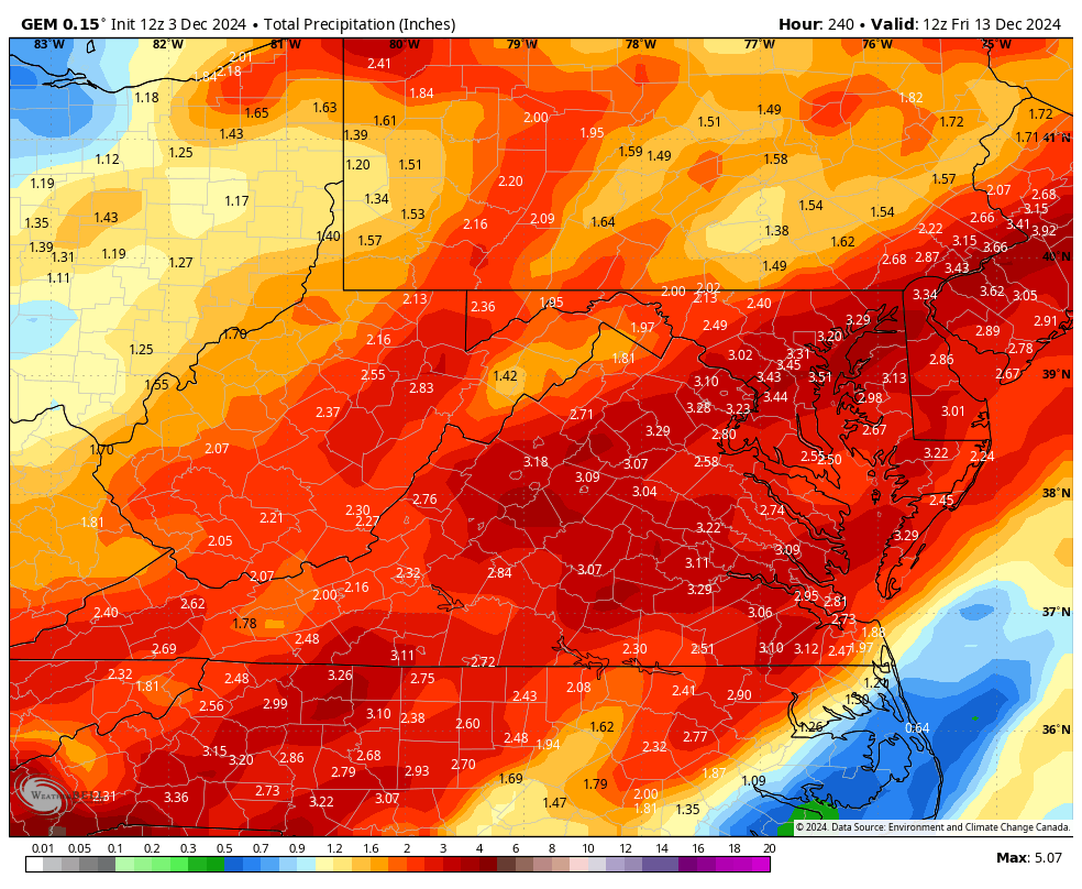
The latest GEM could put a dent in our moderate to severe drought IF it verifies

-
I tied a record low for this morning going back to 1893!!! The record was 10 set in 1976. This morning I recorded 9.7 rounded up to 10.
-
I will give everyone a blast at yesteryear snowstorms in December very soon. White Christmas???? Would you believe 3 big-time in 7 years??????
-
20.6 this morning
-
I hope you're right! Droughts always break eventually. What better way than with 6 - 12 inches of snow. D.C. can have the 12 inches. I'll take 6.
-
As long as we stay in moderate to severe drought, these types of dropouts will not be unusual. Here's the deal:
-
This cold pattern likely to last thru mid month then warm up thru Christmas IMO. No reload evident after mid month on EPS or GEFS at this time.
-
make that -0.4 for both winters.