stormy
-
Posts
2,105 -
Joined
-
Last visited
Content Type
Profiles
Blogs
Forums
American Weather
Media Demo
Store
Gallery
Everything posted by stormy
-
1966 was a very snowy year giving me 76 inches compared to a normal 24!!!
-
The 1-4 week from the 3 pm CPC is warm and dry....................................
-
December of 1966 was white in my area......................... 26 inches of snow...... 11" on the 13th, 2" on the 20th, 8" on the 24th, 5" on the 28th. The Pacific was negative like all of the 60's at -0.21, The Enso was - 0.4 much like this year, the Nao was positive at 0.72, The AO was negative at -1.40.
-
Only .30" liquid qp yesterday.
-
12/15 Possible I81 event. First inch of the season out here?
stormy replied to clskinsfan's topic in Mid Atlantic
Sterling reported 4 inches about 15 miles northeast of Hagerstown. -
12/15 Possible I81 event. First inch of the season out here?
stormy replied to clskinsfan's topic in Mid Atlantic
Light snow mixed with sleet. Sleet began 9:45. A slick glaze of sleet on some colder paved areas. 32 degrees -
12/15 Possible I81 event. First inch of the season out here?
stormy replied to clskinsfan's topic in Mid Atlantic
2.7 inches according to the 18z GFS. I'll let you know when it starts. -
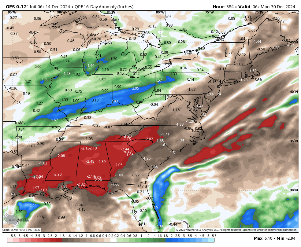
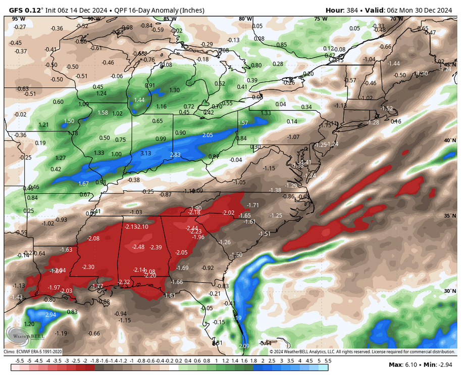
The latest GFS says that well below precipitation continues through December 30. The drought continues;
-
The 18z GFS says the DROUGHT continues thru December 29 with no real relief in sight.
-
When the "Gulf is closed for business" that is not good.
-
If this verifies, both the GEFS extended and Weeklies were incorrect 3 weeks ago.
-
21/22, better upper level support, temperatures surface and aloft look fine especially 81 corridor, as depicted maybe a 20% chance, but that period will need watching.
-
If LP had been dominant along the East Coast for the last 6 months, I would have paid more attention to the 12z GFS. It has been just the opposite!!!! That's why I called it a fluke. The 12z was whistling Dixie.
-
Everybody needs to chill out and wait for 18z and 00z. THIS IS A FLUKE...................................
-
January 6
-
1.09" in the bucket. Temp dropped 3 degrees in past 30 minutes. Down to 48. 35 miles to my west at Monterey it is 34. Spruce Knob is 24.
-
As the resolution improves the likelihood of your desire declines.
-
Will: This is probably a little more accurate considering the nature of the incoming system, though I must question the hole south of D.C.. High res. models sometimes have distortion because of noise and range and angular resolution.
-
This projection is wrong Will. High resolution models often have dropouts for no discernible reason.
-
My visibility is 15 miles except for the fog shield over Afton Mt..
-
I've only received .13, but you're west of me.
-
Talk to psu
-
You are exactly right.............. Some poor folks are hung up on other stuff................... Anyone who has paid attention knows that we were unusually cold during your stated period. For those who did not pay attention, my high temperature during that period was 37 compared to a long range normal high of 49 on December 4....................... Case closed.......................
-
I feel sorry for you. I tied a record low last week going back to 1893. And to tie was a round up .3F.
-
So has mine, way ahead of last year with wood consumption.