George001
-
Posts
6,996 -
Joined
-
Last visited
Content Type
Profiles
Blogs
Forums
American Weather
Media Demo
Store
Gallery
Everything posted by George001
-
If the La Niña keeps deepening (I thought it would be strong last year and it was barely moderate, so not going to jump the gun too early), could 2010-2011 become a decent analog? The MEI is on roids like 2010-2011 and the subsurface is rapidly cooling, so a decrease in surface temps is possible down the line. The 2010-2011 La Niña was extremely strong and dominated the winter pattern.
-
I’m not a fan of the increasing solar and low ACE. That usually means a polar vortex centered over the North Pole which is really bad. It looks horrible right now but it’s still early, there is time for the ACE to increase.
-
The record high for Boston tomorrow is 98, decent chance that gets broken.
-
I agree with the idea that in the winter of 2022-2023, El Niño will be nowhere to be found, much like Tatum was nowhere to be found in the finals. For most moderate strength or stronger El Niño years arent you already in El Niño by now? The March April May average is -1.1 which is moderate La Niña (it does appear to be weakening some this month, but still in weak La Niña territory). The latest CPC/IRI projection has the chances we see El Niño during the winter as less than 10%. Not only is it saying El Niño is very unlikely, it is saying if anything there’s a pretty good chance we are looking at another La Niña! That’s kind of cool, you would think there’s a good chance at getting an El Niño since we just had 2 consecutive moderate la ninas, but it looks like that will not be the case. Another thing that suggests that we could see another La Niña is the MEI index, the MEI index for April and May was recorded as -1.7, which is even lower than it was during winter. If anything, although guidance seems to be keying in on a weak La Niña, there is still a lot of spread. There are quite a few models taking the La Niña to moderate strength with a couple even suggesting we could see a strong La Niña, and only a couple of members even have a weak El Niño. I don’t know if it means anything, but could the extremely low MEI index suggest that the models are underestimating how strong this La Niña could get in the winter? Even if the Nina according to ONI index has weakened some lately, it could easily restrengthen and potentially increase in strength throughout the fall and winter, as we are still a ways away from peak nina climo.
-

George’s official winter forecast for the Boston area
George001 replied to George001's topic in New England
My winter forecast ended up being a fail. There were some warning signs but I don’t know how the polar vortex was able to deepen so much. It was record strength, which screwed us late winter. This winter was decent in my area because of the blizzard, but pretty much everywhere outside SE Mass it was bad. I know the solar was more active than expected, but I would think to get the polar vortex to deepen so much it would take something extreme to do that. Maybe the volcanic activity earlier in the year? I read that the year after a big volcanic eruption there is evidence suggesting increased probability of a positive NAO. I hope the polar vortex shatters into a billion pieces next year. -
March 2022 Obs/Disc: In Like a Lamb, Out Like a Butterfly
George001 replied to 40/70 Benchmark's topic in New England
The low on the Canadian a few days ago went poof, just like that. Very unfortunate. -
March 2022 Obs/Disc: In Like a Lamb, Out Like a Butterfly
George001 replied to 40/70 Benchmark's topic in New England
Weed -
March 2022 Obs/Disc: In Like a Lamb, Out Like a Butterfly
George001 replied to 40/70 Benchmark's topic in New England
Yes, we need to see the signal strengthen on the ensembles though. It is a long shot for sure. -
March 2022 Obs/Disc: In Like a Lamb, Out Like a Butterfly
George001 replied to 40/70 Benchmark's topic in New England
That’s a very strong low
-
March 2022 Obs/Disc: In Like a Lamb, Out Like a Butterfly
George001 replied to 40/70 Benchmark's topic in New England
There’s a low on the eps. Cold too
-
Too early to tell. If we do though, if the polar vortex doesn’t end up stronger than normal the winter should be better. The past couple of la ninas have done a good job cooling off the ocean, leading to a weaker pacific jet. La Niña with blocking is very good.
-
March 2022 Obs/Disc: In Like a Lamb, Out Like a Butterfly
George001 replied to 40/70 Benchmark's topic in New England
Wouldnt the blocking force secondary redevelopment, leading to a Miller B? That happened during the big December storm a couple years ago that buried Binghamton NY. The low initially cut west and buried Wisconsin, but it redeveloped to the south and turned into a Miller B. Or at least an SWFE, I don’t get how all that warm air can flood north. -
March 2022 Obs/Disc: In Like a Lamb, Out Like a Butterfly
George001 replied to 40/70 Benchmark's topic in New England
How can it cut into the block? I’m not buying that, maybe it won’t be a snowstorm, but the low won’t just ram into the block. -
March 2022 Obs/Disc: In Like a Lamb, Out Like a Butterfly
George001 replied to 40/70 Benchmark's topic in New England
12z euro extrapolated looked like it would have been an interesting solution for early April. I’m not sure how much if any of the precip would be snow, but it did look like a bowling ball was going to track under us. -
March 2022 Obs/Disc: In Like a Lamb, Out Like a Butterfly
George001 replied to 40/70 Benchmark's topic in New England
I have toned it down a bit. I still jump the gun sometimes but this I am willing to accept feedback. This post is a bit harsh, but completely fair and nothing you said here is really inaccurate so I’ll work on it. I probably shouldn’t have started talking about blizzards off just a good H5 look (I’ll edit the post so it’s toned down) but man it’s a really good look. I don’t entirely remember all the details of our last exchange, but I do remember taking offense to something you said and got defensive as a result. I don’t really want to make enemies here so I’ll forget about that and clean up my posts. Fair enough? -
George’s official winter forecast for the Boston area
George001 replied to George001's topic in New England
What’s your seasonal total so far? -
George’s official winter forecast for the Boston area
George001 replied to George001's topic in New England
Didn’t you get over a foot of snow in the Jan blizzard? I consider the difference between a bad winter and a true ratter to be no storms with a foot or more of snow. That’s the difference between say 2018-2019, which sucked but had one storm with over a foot of snow in my area, and 2019-2020 which was a true ratter. Also, it’s bowling ball season. We still have time for another blizzard, which could change the overall grade of the winter. I read that 1996-1997 had like 20 inches of snow the ENTIRE WINTER in Boston, until the early spring April fools blizzard brought the seasonal total up from ratter to average. -
March 2022 Obs/Disc: In Like a Lamb, Out Like a Butterfly
George001 replied to 40/70 Benchmark's topic in New England
I think we’re going to get a bowling ball, the only issue is wave spacing on the models right now. I do not think that will be an issue at all, as with the North Atlantic blocking in place timing shouldn’t be too much of an issue. There will be plenty of time for the northern energy to phase in and catch a piece of the southern energy. This time of the year thermals are a concern, but if the low location is good and it’s strong enough it will create its own cold air. A possible scenario is the storm starts as rain, but then as the low deepens it creates its own cold air via dynamic cooling, leading to the rain transitioning to some snow. The North Atlantic blocking in place ups the ante, leading to the storm slowing down. When combined with the bowling ball low closing off quickly, a storm loaded with QPF is very possible. The question is how much will be snow. Right now the surface maps have the low too far south, but the upper air pattern suggests that the low has room to come north.
-
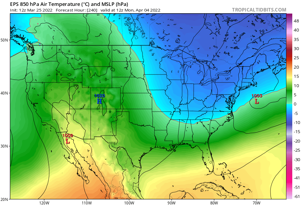
March 2022 Obs/Disc: In Like a Lamb, Out Like a Butterfly
George001 replied to 40/70 Benchmark's topic in New England
Upper air pattern on eps for next weeks nor’easter threat
-
March 2022 Obs/Disc: In Like a Lamb, Out Like a Butterfly
George001 replied to 40/70 Benchmark's topic in New England
Miller B?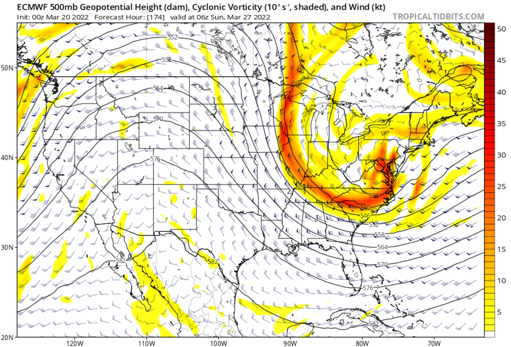
-
March 2022 Obs/Disc: In Like a Lamb, Out Like a Butterfly
George001 replied to 40/70 Benchmark's topic in New England
Just because the weather has gotten milder lately doesn’t mean snow is done. Big ridge out west, trough in the east, and most importantly we have North Atlantic blocking! With the late March shortening wavelengths combined with a favorable western ridge placement and North Atlantic blocking in place, there is an incredibly strong signal for a BOWLING BALL!!!! We go bowling every year in that early spring timeframe, but we kinda suck at it. The problem isn’t that we aren’t capable of throwing strikes, we have the strength to put enough juice on the ball to knock all the pins down. The problem is we have the command of the Red Sox bullpen last year, so absolute dogshit. That’s why most years when we bowl, we only knock down 1 or 2 pins at most. Often we will chuck a gutterball, and our worst bowling sessions (March 2012), we chuck that shit into someone else’s lane, they get pissed, complain and you get kicked out of the bowling alley. Other years, like April 1997, our wildly innaccurate arm somehow manages to chuck it right down the middle at full speed, a clean strike. This is very rare, but when it happens, it’s a thing of beauty. This year, we have whiffed and whiffed, and are on the last frame. We have chucked the bowling ball, and it hasn’t gone into the gutter or someone else’s lane, it actually looks like it’s going right down the middle. Will it stay the course, or sharply hook left/right, leading to a whiff? We will find out next week!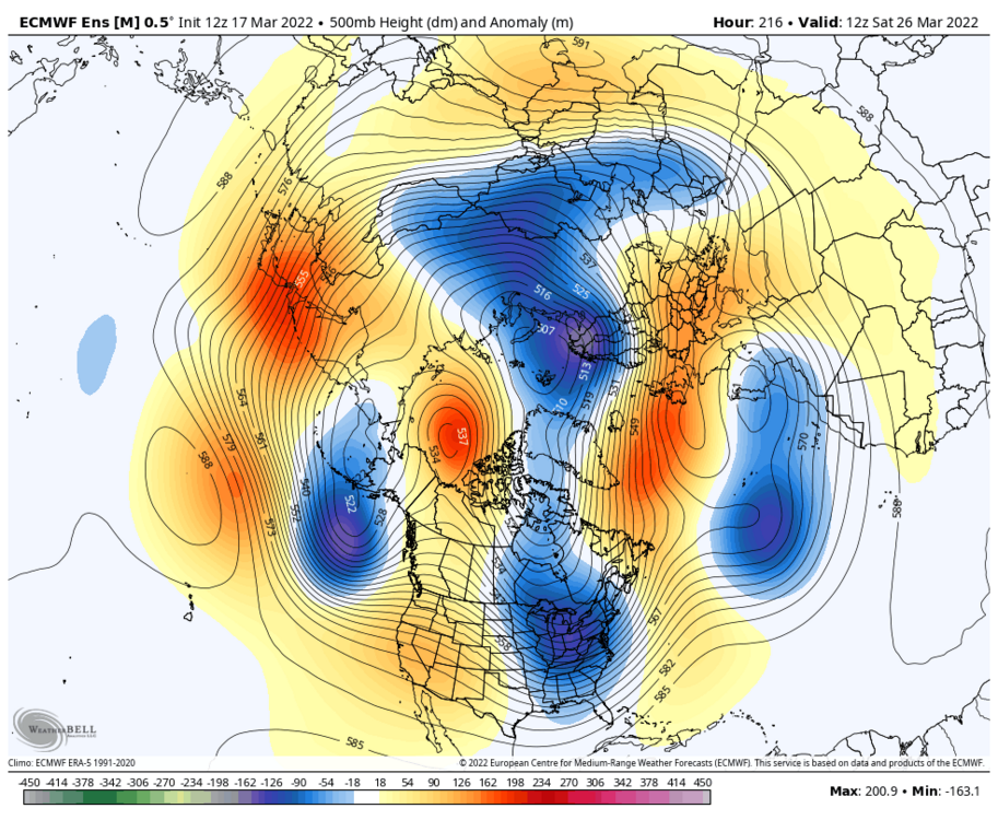
-
George’s official winter forecast for the Boston area
George001 replied to George001's topic in New England
It was a warm fall but that doesn’t matter too much in terms of what happens in the winter. -
March 2022 Obs/Disc: In Like a Lamb, Out Like a Butterfly
George001 replied to 40/70 Benchmark's topic in New England
Whatever it is the gfs is smoking, I want some of it. -
March 2022 Obs/Disc: In Like a Lamb, Out Like a Butterfly
George001 replied to 40/70 Benchmark's topic in New England
The euro is holding the energy back in Mexico. That is a long range Euro bias, as it gets closer in there’s a decent chance we could see it start ejecting more energy. This would lead to a nor’easter threat. -
95-96 looked like a decent analog because due to the strength of the La Niña and it being east based. Unfortunately the polar vortex deepened to record strong levels, which wasn't supposed to happen, especially considering how weak it was in November, but it did anyways. Hopefully it’s weaker next year.