George001
-
Posts
6,996 -
Joined
-
Last visited
Content Type
Profiles
Blogs
Forums
American Weather
Media Demo
Store
Gallery
Everything posted by George001
-
Based on what’s happening now it looks promising for a -NAO. La Niña+ -NAO is a really good combination for us, even in stronger Nina’s.

-
The long range model forecasts show no signs of the blocking breaking down. Even if the storm next week doesn’t pan out, based on what the models are showing a -nao December looks likely. Im convinced we have a big December incoming based on this.
-
For late November 8 days out thats really good, though for my area it’s probably more like 15%. A scenario where I rain and West of the river gets buried with a foot is very realistic. The mild Atlantic Ocean often screws us closer to the coast in these early season events, even with a perfect setup. The fact that we even have something to track this early shows how good the pattern is.
-
Yeah I’m not going to jump the gun this time. The EPS just shifted from a low in Wisconsin to slightly offshore in one run. 8 days out is a long time in weather, and they seem to struggle even more during seasonal transitions and La Niña events (especially stronger ones). I’ll likely wait for someone else to start the thread for this one or make one when it’s 3 or 4 days out if the low is still there by then.
-
Those positive NAO solutions can be thrown out the window looking at the ensemble guidance for late November and early December.
-
It started off as a cutter but is turning into a miller B on the models now.
-
Hell yeah, this threat won’t pan out (like many here said, I jumped the gun creating this thread) but the overnight guidance trended towards a Miller B for the next threat. The EPS is showing early and aggressive secondary redevelopment, with a low strong enough to potentially create its own cold air.
-
The blocking isn’t all that strong so the secondary redevelopment being too late for us makes sense, but on the surface the Euro and EPS are plowing the low into Wisconsin like there is no block whatsoever.
-
The models have a cutter but with North Atlantic blocking I don’t buy that. I don’t see why the low would just ram into the block and ignore it, that doesn’t make sense to me. The blocking argues for the low to run into a brick wall and then transfer off the coast before undergoing rapid cyclogenesis, aided by the unusually warm Atlantic Ocean (Miller B).

-
that’s a lot of blocking
-
 Same here, the snow took me by surprise. Nice little early season event
 -
I’m all in
-
Yeah the whole polar vortex split, SSW stuff is overhyped a lot. I fell victim to buying in quite a few times over the past few years. Even if it splits favorably we need the polar vortex to not recover. Sometimes it splits and then just recovers immediately so nothing really happens for us. What causes the vortex to recover fast sometimes where as other times it says shattered into pieces for an extended period of time?
-
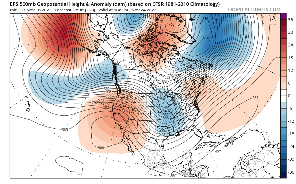
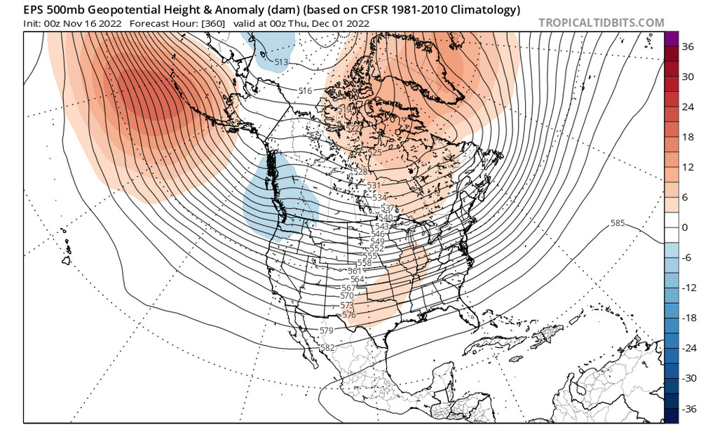
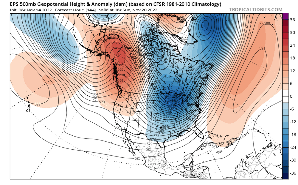
The surface maps don’t really show anything but the h5 looks interesting on the EPS.
-
I could be wrong, but Im not really buying the suppression due to how far west the western ridge is centered at looking at the h5. The Ideal location for nor’easters is centered over Montana, and this ridge is centered west of Washington. If anything wouldn't that suggest that the threat is an inland runner with rain (especially considering the minimal blocking)? If the aggressive and amplified northern stream digs and phases in, wouldn’t that prevent suppression? It looks like if something does happen it would be driven by the northern energy. You bring up a good point about the Wednesday storm though, I wasn’t really thinking of that. We need the northern energy to delay more to give the SE ridge more time to rebuild.
-
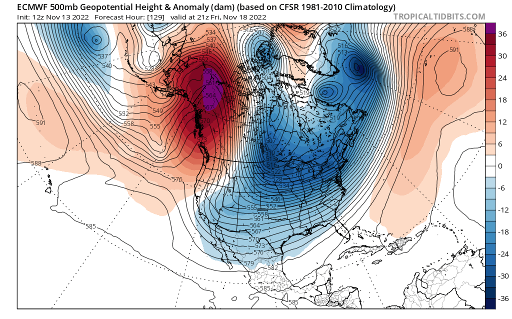
This pattern looks really interesting. There is a very strong western ridge and a very potent northern branch. All that northern energy digging into the Midwest makes me think there is some potential for the Miller A being shown right now to turn into a Miller B. Some other models are showing suppression, but I’m not really buying that. There are several factors on the 12z Euro arguing against suppression. 1. Look how far west that western ridge is, it’s centered about 200 miles west of ideal for a 40/70 track. In fact, it’s so far west it argues that the risk is for an inland runner if anything. 2. How poleward the western ridge is, it’s so poleward it extends all the way into the North Pole. Whatever northern energy there is will likely be digging aggressively. 3. El Niño is nowhere to be found. The northern energy diving down in central Canada gets down to 504 isobars, and the isobars are very tightly packed. That energy’s origin is the North Pole. The Jet stream just doesn’t get that far north in El Niño. La Niña is in full control, which argues against a southern stream dominant solution. disclaimer- if the blocking doesn’t strengthen, it might rain.

-
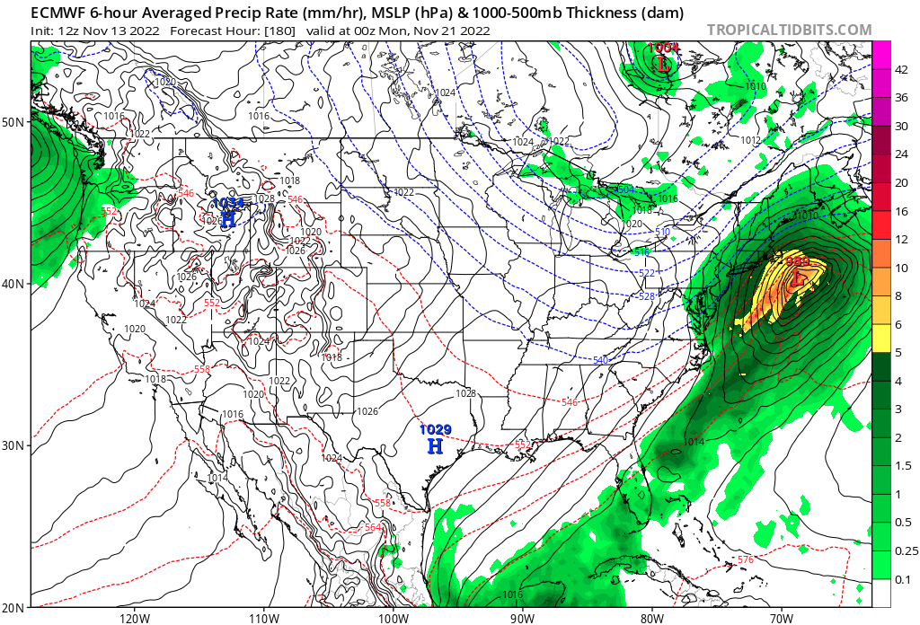
Based on what I’m seeing on the models I think there could be a very real chance we see our first snow in SNE next weekend. This Wednesday is a sneaky threat as well, as it has trended towards more aggressive secondary redevelopment with the low (Miller B). If it were mid winter I would be very excited about the mid week threat, but the pattern is progressive with no blocking so I’m thinking it’s a rainstorm for us. The pattern next weekend looks better on the models, with a much more amplified trough. Looking at the surface map it looks like a Miller A nor’easter, and would bring a few inches of snow verbatim. Nothing too big. However, the H5 tells a different story….

-
due to the lack of cold air with climo working against us, we need a big slow moving nor’easter that creates its own cold air via dynamic cooling to have a shot at snow. The pattern on the models does not support that, the NAO is positive and the western ridge is farther west than ideal. That supports the idea of the low running inland with limited secondary redevelopment (Miller B). The western ridge is quite strong so it’s possible the storm and trends more amplified, which would increase the QPF. Even if that happens though, that would just mean more rain for us. That map posted above saying my area has a 33% chance of wintry weather seems way too high. NNE could cash in but for us in SNE we probably need to wait a month or so.
-
Yeah it’s too early for us outside of NNE, not enough cold air yet.
-
Winter 2022-2023 Promises Plenty of Mid Season Mayhem
George001 replied to 40/70 Benchmark's topic in New England
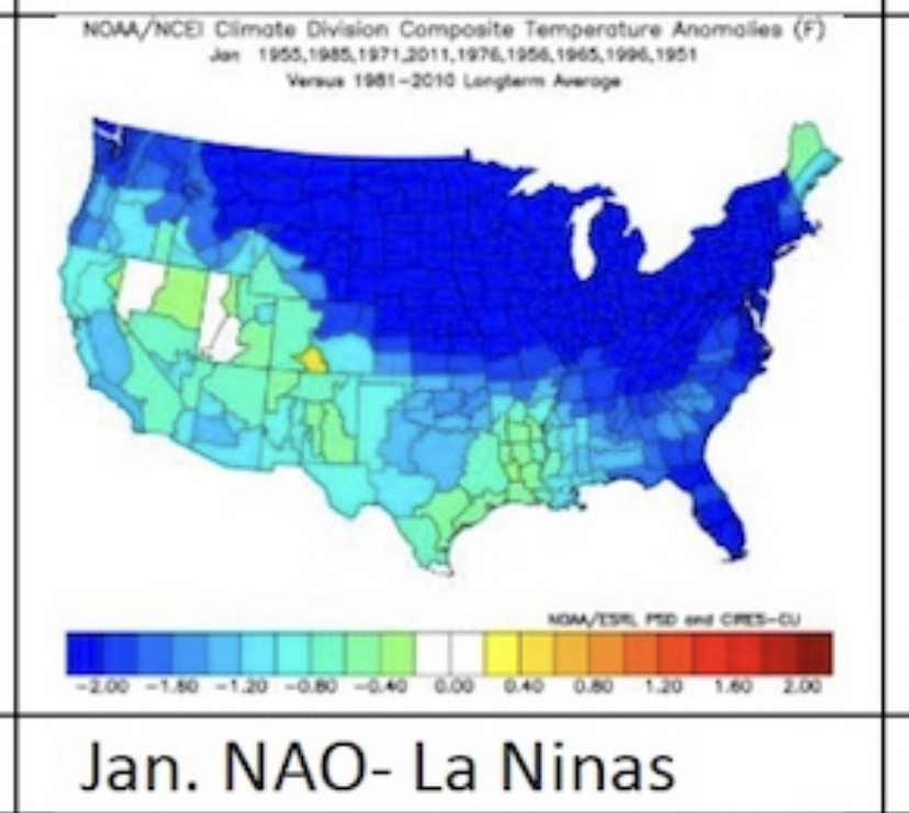
As always great work, I hope you are right about January. The mention of a once a generation type event with the potential to halt travel for a while caught my eye. The combination of factors you mentioned, with the drastic increase in water vapor due to the volcanic eruption last year, the frigid Canadian air and very mild ssts all creating the perfect storm for something big. Those same mild ssts that will likely screw us closer to the coast early could end up helping come mid winter before the blocking breaks down in Feb. It looks like you are thinking the large scale winter pattern will be an overall average East coast winter, with lots of ups and downs, no sustained snow blitz but no sustained blowtorch either. There isn’t an overwhelming blockbuster signal like 2014-2015, but there isn’t an overwhelming mild signal like the super nino in 2015-2016 so that seems reasonable, maybe a little less snow than last year in the Boston area and more snow NW like your area, Worcester ect. I would like to ask, you did mention that the way the month of November is progressing worried you about your analog composite somewhat I believe it was a week ago. If things were to deviate as a result of that, would that lead to more boom or more bust potential for this winter? -
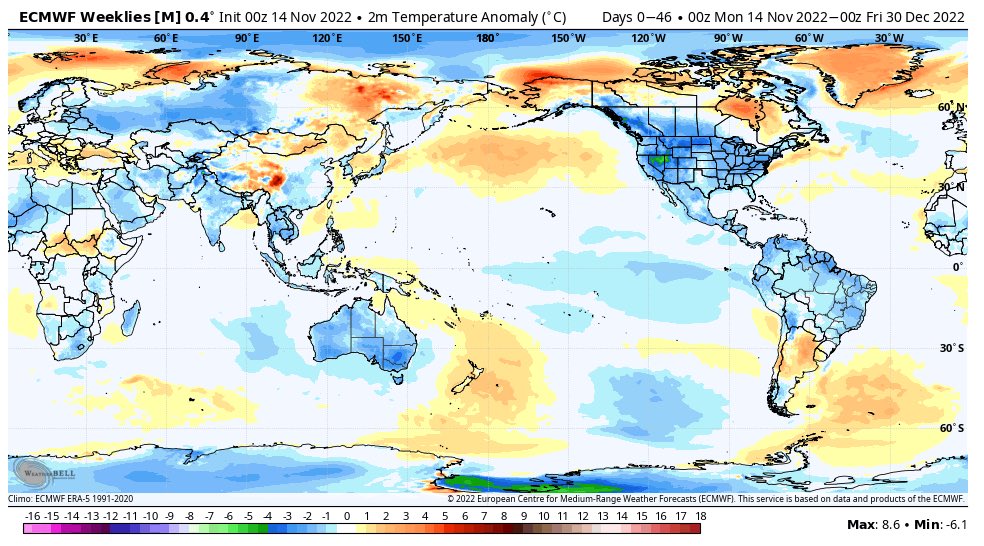
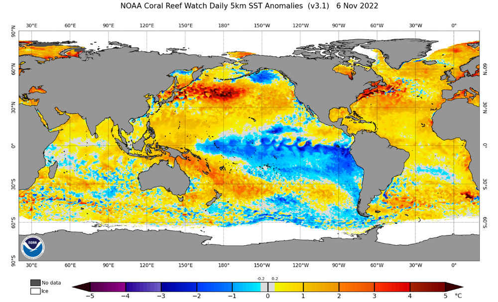
the bigger story here is the strength of the La Niña. There is still quite a bit of spread on the models about how strong the Nina will get, and it looks like the more aggressive models have the right idea looking at this. People who were talking about the possibility of a +PDO likely anticipated that the Nina would be weak, but that beast we currently have in the Pacific Ocean is anything but weak. The Nina is already stronger than last years Nina at this stage and has intensified over the past couple months.
-
The La Niña clearly isn’t east based, which isn’t surprising considering East based Nina’s are normally weak unlike that goddamn beast we currently have in the Pacific Ocean. It’s basin wide, but it’s strongest in the eastern areas rather than the western areas like last year.
-
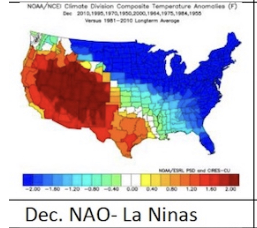
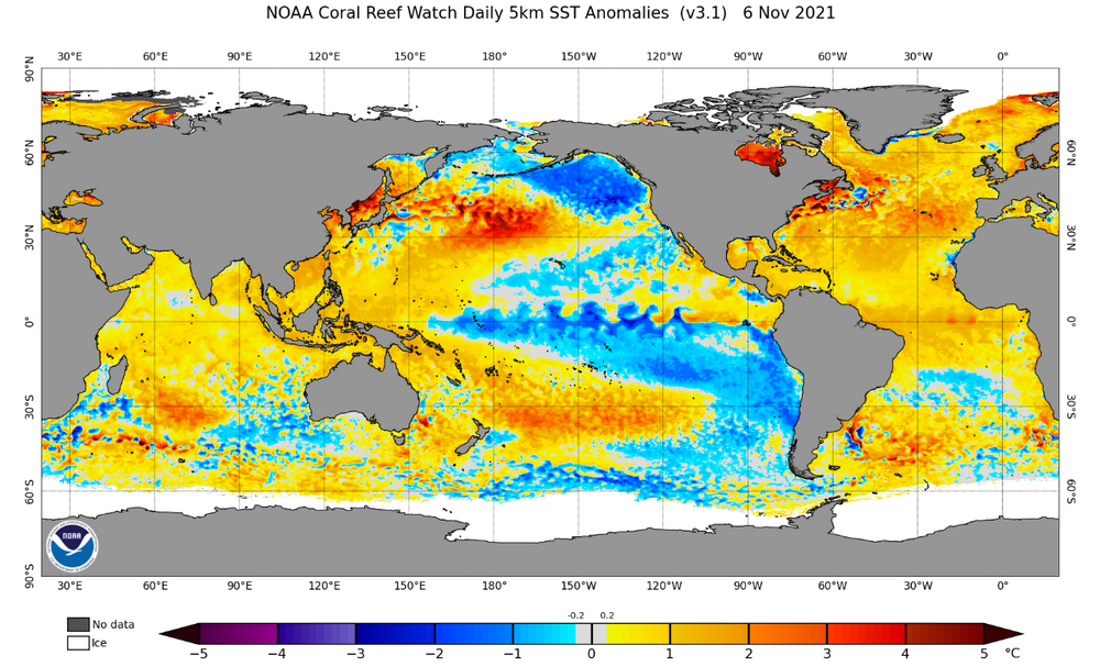
For comparison purposes this is last years Nina, which peaked at -1.0 or right on the border of weak/moderate. It’s not even close.
-
One of the reasons why I’m starting to get really excited about the potential for a big December is the La Niña. I was of the impression that the La Niña was going to be weak by now, and be nearly gone by late December. That impression was based off the models a couple months ago, and things changed. That La Niña is not weak, not even close. I saw a comparison with this years La Niña and last years from early November on another board, and this years looks quite a bit stronger. It’s WAY stronger in the eastern 3 and 1.2 regions, but it’s also stronger and more expansive in the 3.4 and 4 regions as well. It’s straight up just a stronger La Niña, and is basin wide. This is reflected by the MEI values as well. Am I smoking some good shit, or does this Nina look closer to 2010-2011 than 2016-2017? I know it’s not super impressive by ONI but the area of below average temps is just so much more expansive than I would expect to see from a weak nina.
-
The pattern looks like it’s going to turn cold according to the models. I’d bet we start seeing snow threats pop up on the models soon, possibly even 1 or 2 runs showing a blizzard! Now it is November, so it’s very unlikely that it will even snow at all never mind a major nor’easter/blizzard. I’m just saying, the models will probably start showing it soon. Even though those fantasy storms won’t happen, it’s a good sign that the pattern is moving in a favorable direction going into December. The way things are going, in a month there’s a decent chance we will be tracking a storm for real.