George001
-
Posts
6,996 -
Joined
-
Last visited
Content Type
Profiles
Blogs
Forums
American Weather
Media Demo
Store
Gallery
Everything posted by George001
-
Yeah….. I don’t think we have to worry about lack of a SE ridge.
-
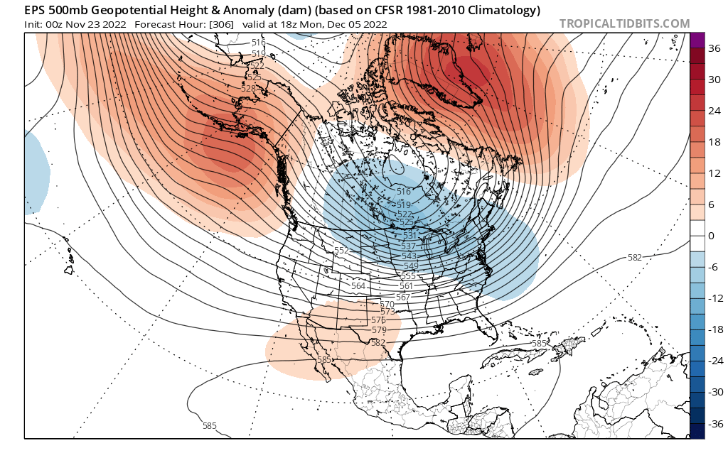
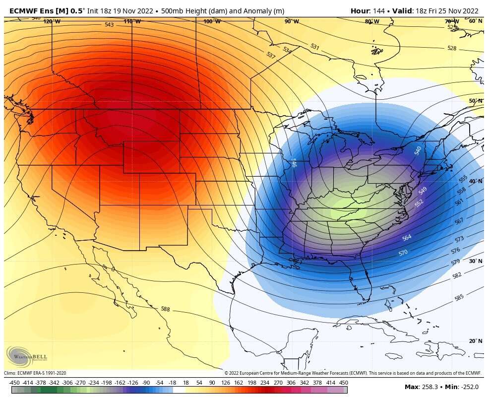
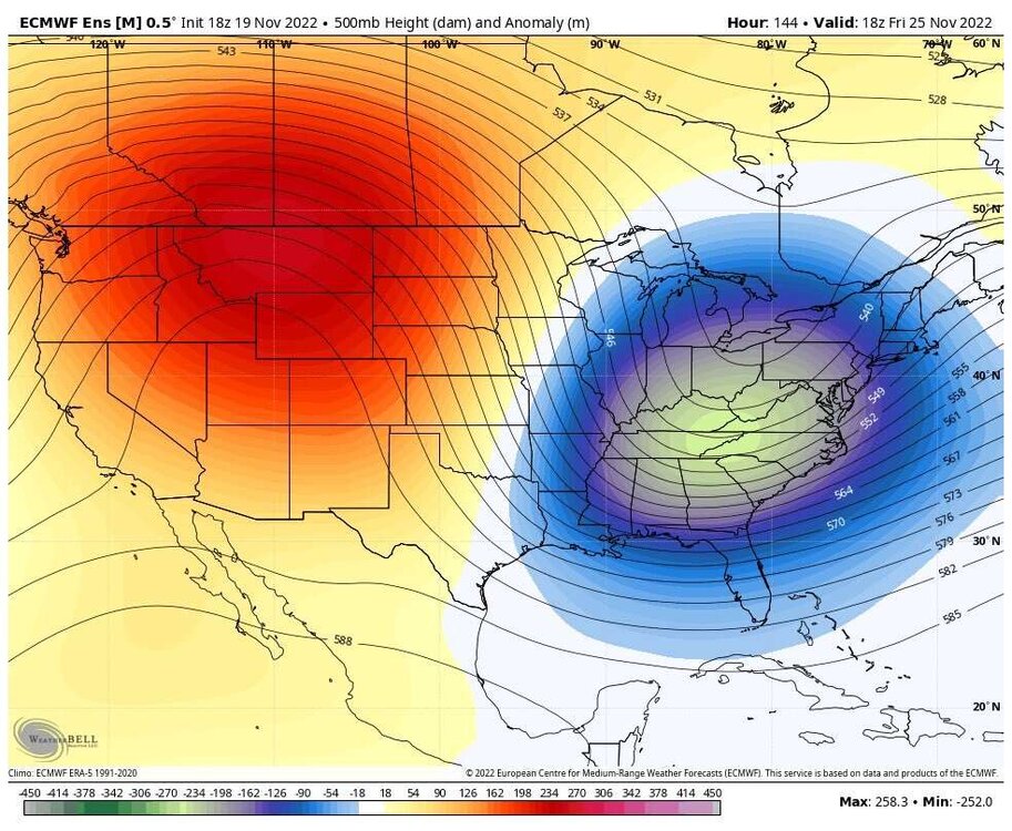
With blocking that severe the ceiling for this December is very high, as in 20+ inches of snow for the month in most of SNE. That is a lot, but it only takes one storm to reach those amounts with this severe North Atlantic blocking pattern. Instead of getting 12 hour storms with a positive NAO in this pattern due to the blocked flow the low isn’t going anywhere, so we would get 24 hour storms instead, possibly longer. With the warm ssts offshore I’m thinking a March 2018 redux, where the NW areas get clobbered with the first storm or 2. Then mid to late month when the cold air is more established (there are signs of a polar vortex displacement event on the models, despite no SSW), the clash between the northern airmass and the mild early season Atlantic Ocean SSTs leads to any area of low pressure forced to redevelop offshore due to the blocking to undergo rapid cyclogenesis as it comes up the coast, deepening into the 960s. On top of this, we have the increased water vapor in the atmosphere due to the volcanic activity last year, this increase in water vapor will lead to truly obscene QPF totals.
-
I would be worried if we were in a moderate to strong El Niño. This pattern looks more 2010-2011 than 2009-2010.
-
I disagree it’s a La Niña pattern with blocking. The SE ridge that shows up in la Ninas is good for us because it prevents suppression. Even Metfan could get a lot of snow from this pattern if the models are right. The blocking will force Miller B redevelopment, which is great for our area. In fact, Miller Bs are better than Miller As in New England.
-
For point number 2 while that’s true the blocking will increase our chances especially by late December. All it takes is one storm anyways with this blocking.
-
EPS too

-
The eps pattern is almost perfect for us. We have the blocking to prevent cutters and force secondary redevelopment (Miller B). We have some SE ridging as well to prevent suppression so we won’t have to worry about a repeat of 2009-2010 or 2015-2016.
-
The polar vortex is a lot weaker than last year
-
The models rush pattern changes a lot. Delayed but not denied. During transition periods the models are completely lost just like Zach Wilson is when he drops back to pass.
-
Eh all the models were terrible with it. They were too early with bringing the blocking in which is why the threat isn’t going to pan out. We need more blocking.
-
Care to explain where I’m wrong?
-
No shit Philly and DC arent getting anything, it is late November with powerful La Niña in place. However, lows bombing out and and making their own cold air is a real thing. Is it likely to be enough for SNE? No, it’s a long shot because welp it isn’t winter and everything has to go right for it for us to get big snows. I’m not saying 100% of the QPF will be snow (it won’t), but a rain to heavy snow scenario right into the Boston and NYC metro areas is still in the cards. I’ve seen it happen, it happens all the time in March nor’easters.
-
It’s unlikely it snows in my area but I wouldn’t rule it out. 2 feet, no but I guess there’s an outside shot at a slushy foot. Hell even Metfan is still tracking the storm.
-
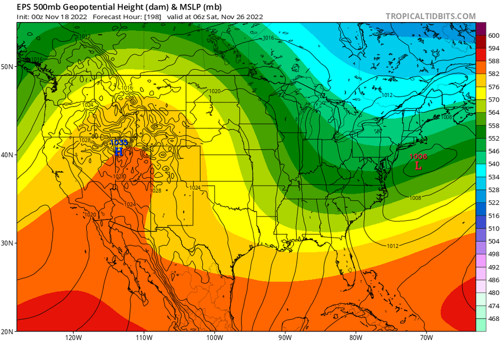
Good low location though. Verbatim it isn’t good, but If the low bombs out more it can create its own cold air.
-
Storm coming back?
-
The positive EPO isn’t good, agreed. However there is blocking to prevent storms from cutting to the west. Cold air will be an issue but if the low is strong enough it can create its own cold air.
-
Yeah there is plenty of time for change for better or worse. Hopefully we see the blocking strengthen and become more west based as we get into December.
-
I don’t think that pattern is too bad. The pacific sucks but there is a lot of blocking which makes up for it.
-
Clown all you want but he’s right. All signs point to a negative NAO in December. Missing out on a low probability to begin with late November storm doesn’t change anything. A lot of times the models are too quick with the pattern change and it looks like this is one of those times. Delayed but not denied with the -NAO.
-
The blocking got weaker on the models so the secondary redevelopment will be too late for us. Oh well December still looks promising with all signs pointing to a negative nao.
-
Models are still all over the place, there hasn’t been any consistent trend. The probability of something big here is low because of the time of year, but it’s too early to write the storm off. We are still getting North Atlantic blocking so we can get big snows even if the pac is bad for early December. The mid Atlantic may struggle more.
-
Eps has good low location
-
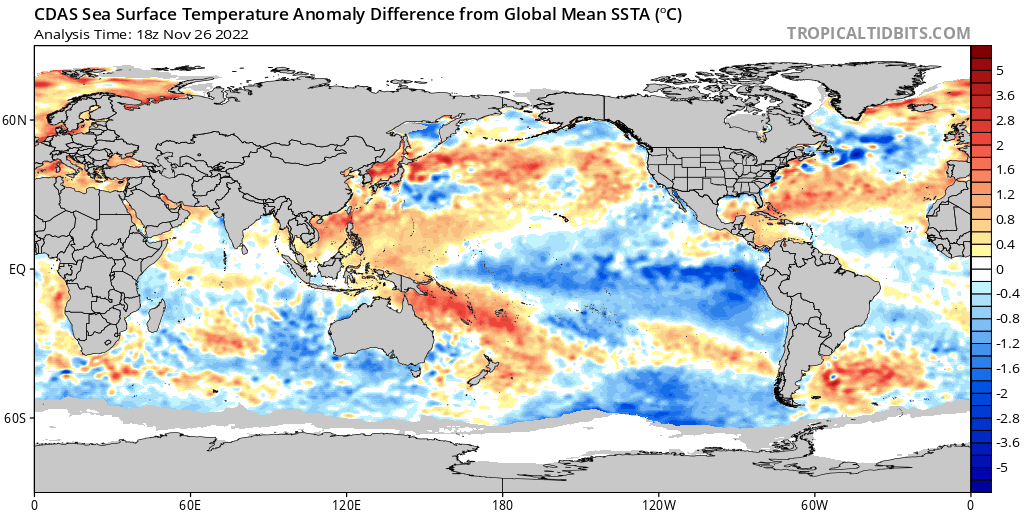
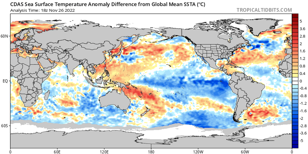
With blocking the biggest concern is suppression, especially in El Niño patterns with a farther south storm track. Fortunately is 0 signs that we will have anything remotely resembling an El Niño pattern this winter.
-
To be fair to Snowman he’s right, the La Niña is quite powerful and will likely be one of our main pattern drivers this winter. However, this doesn’t mean what he likes to imply. The storm track is shifted further north with Nina’s, which when combined with North Atlantic blocking eliminating the risk of cutters leads to a lot of Miller B nor’easters. In a moderate to strong nino with a big -NAO there is a much higher risk of suppression with congrats DC and Philly. That is not a concern, as it is more likely that an asteroid strikes my house and kills me tomorrow than it is for us to experience El Niño conditions this winter.