George001
-
Posts
6,996 -
Joined
-
Last visited
Content Type
Profiles
Blogs
Forums
American Weather
Media Demo
Store
Gallery
Everything posted by George001
-
I think Boston breaks 100 inches this year. I think the NAO will stay negative the entire winter based on the latest long range data.
-
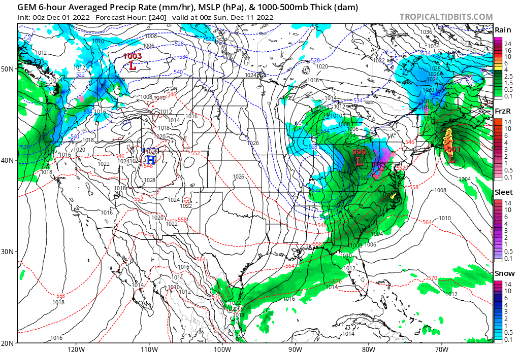
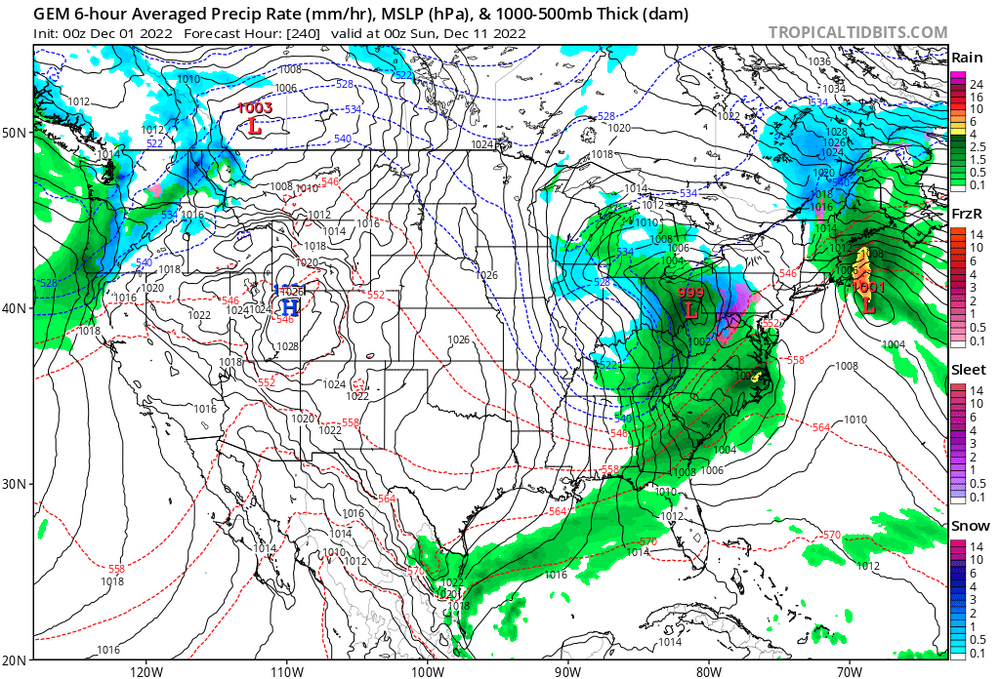
I’m all in with the Canadians evolution. It has a fairly weak low hit us the 9th, then the low slides offshore and looks like it’s going to continue sliding east. In most patterns, it would. However, the blocking doesn’t let the low move east. It has no choice but to come back and hit us again, and it deepens rapidly due to the warm Atlantic Ocean waters. The airmass is not all that cold, so we will be fighting rain snow lines. That is very much a risk this early in the season, however if the low gets strong enough it can and will create its own cold air. It looks like that is what the Canadian is hinting at, the airmass is fairly mild but the low creates it’s own cold air. This dynamically cools the column, leading to the rain snow line crashing SE. We get over 2 straight days of precip, with some areas in SE mass getting 3+ inches of QPF! Obviously it isn’t all snow, but still it shows just how much potential this pattern has. People clown on the Canadian a lot but I think it has the right idea. Whatever storm that hits us is going to just sit there and rot over us, leading to crazy high QPF outputs. The whole GFS idea of linking up the SE ridge to the block is complete bullshit, it’s more likely that the Patriots win the Super Bowl this year than that actually happening.
-
 DCA _ NYC _ BOS ___ ORD _ ATL _ IAH ____ DEN _ PHX _ SEA -1.9 -2.3 -2.5 -3.1 +.8 +1.3 -5 -3.8 -4.6 DCA _ NYC _ BOS ___ ORD _ DTW _ BUF ___ DEN _ SEA _ BTV 12.0 62.0 105.0 65.0 70.0 140.0 60.0 8.0 130.0
 -
It starts as rain yes, but the Midwest low looks like it’s starting to transfer offshore and absorb the smaller retrograding low to make one massive low. Looking at the H5 I would think the low would strengthen enough to create its own cold air, leading to the rain snow line crashing south.
-
The low in the mid west is turning into a Miller B and looks like it’s somehow pulling the coastal low in to absorb it. I…. have no idea what I’m looking at here and what this would look like if you extrapolate it
-
This doesn’t scream suppression at all
-
How is that even possible? Snow in Philly while it rains in NNE with the low offshore.
-
The Pope is very angry today, some shit must have gone down at church. I’d bet he caught a certain Brooklyn cop looking at weather models during a sermon or something.
-
I guess it’s possible to come up empty but I would think to come up empty in a pattern like this would require a great deal of bad luck. Even with average luck I would think we get at least 1 big one.
-
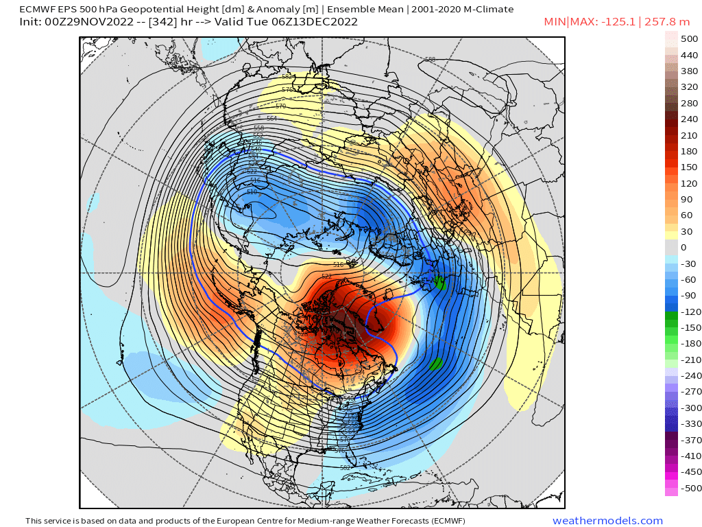
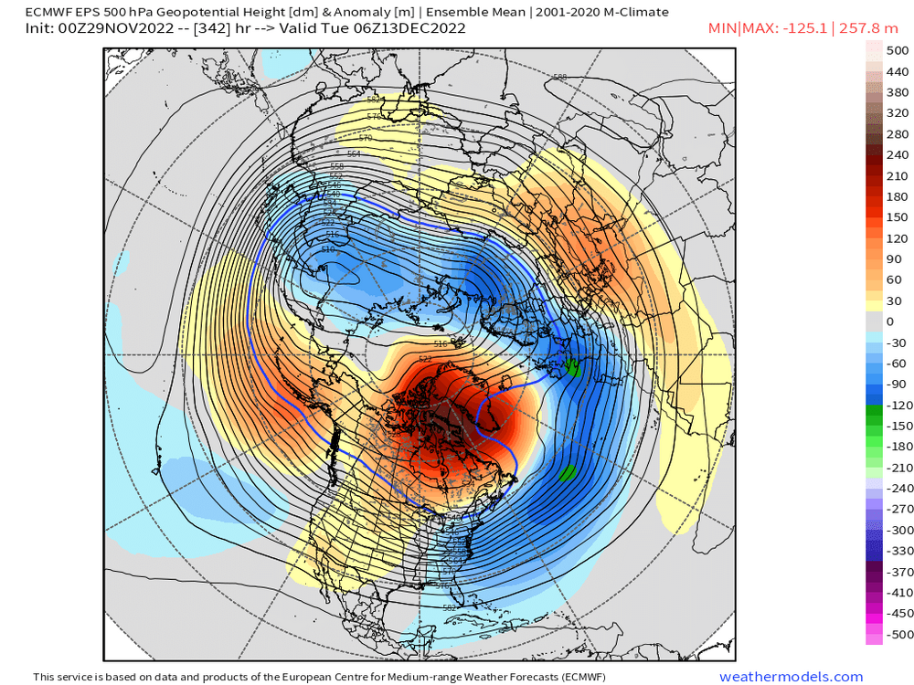
The setup for mid month is loaded, historically strong North Atlantic blocking, a western ridge centered over Montana (ideal for east coast cyclogenesis), and excess water vapor available for storms to tap due to the volcanic activity last year and the mild early season Atlantic Ocean. What was really interesting was the end of the Euro run, it looked like it was about to phase a piece of the vortex over southern Canada into the storm (the northern and southern branches are already starting to phase over the Midwest). This run it likely would have been a bit late with the 3rd piece, but if that dives in a little earlier the ceiling drastically increases. Either way we’re getting a Miller B nor’easter/blizzard in my opinion, but the question is are we getting a double phaser or triple phaser. Triple phasers are very rare, so the odds are low, but due to the magnitude of the blocking the odds are higher than they usually are. The farther NE you are, the better the chance is of that 3rd piece phasing in. Even without it, due to the magnitude of the block the low will be in no hurry to leave, and with all the water vapor in the atmosphere combined with the arctic Canadian air clashing with the mild Atlantic Ocean we could easily see 3+ inches of QPF with a double phaser. If we get a triple phaser, all bets are off and we could be talking 5+ inches of QPF.
-
Miller B?
-
That’s a good point, to get those insane snowfall totals you need both a great pattern AND luck. That Feb 2021 storm mu area got 8 inches or so, but just a 20 min drive NW and there was 18 inches of snow on the ground. It’s very easy to get screwed like that even in good patterns especially closer to the coast.
-
I’m expecting around 2 feet total give or take by the end of December in my area. NW 3-4 feet.
-
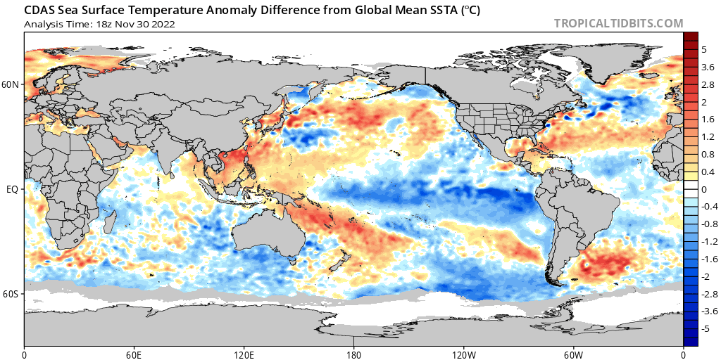
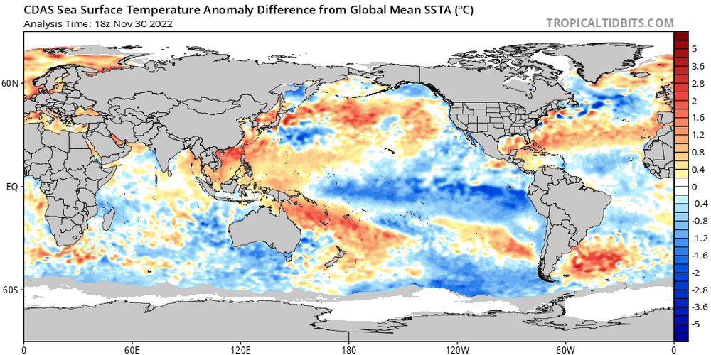
The La Niña has not been the problem. The lack of North Atlantic blocking has been a big problem. The models are saying this year will be different. Maybe they will be wrong, but I don’t think it’s likely. How often does blocking this strong on the models just vanish?
-
Yeah I don’t see how you can possibly be negative about our chances with this look.
-
The SE ridge is good it prevents suppression.
-
the change in the polar vortex forecast bodes well for Jan-March as well.
-
Ah that’s too bad, but the increased water vapor could still lead to an increase in low strength. The question will be if that will be enough to offset the warming or not.
-
Holy shit that’s a lot of material! The material from the volcano isn’t going to disappear and do nothing. There are already signs that all that material is being absorbed into the stratosphere. Yes, we don’t live in the stratosphere but what goes up must come down. I don’t think the brunt of the material has came down yet, but once it does I think it will be absorbed into low pressure systems, and will help them strengthen to historic levels. I’m not a met so I don’t really know when all the material is coming down, but I know it has to come down eventually. It’s possible this December is just the beginning, and come February and March is when we get the brunt of the effects of the material from the Tonga eruption coming down from the stratosphere. If that’s indeed the case, this could end up becoming a record breaking winter. Not only that, but it could also mean the next few winters are also severe.
-
The blocking needs more time to establish itself. December 6th is TOO EARLY! It might even *gasp* RAIN! Does that mean it’s time to call off the epic pattern and 20+ inch December for all of SNE? HELL NO! Look at what happened in the analogs for this coming pattern that people talked about (Dec 2010, Jan 2011, Mar 2018, Feb 2013, Mar 2013, ect). The snow blitz didn’t start as soon as the blocking set up, it took some time for the pattern to develop. We’re gonna have to wait most likely. Anyone who’s panicking because the OP runs aren’t showing multiple blizzards should keep in mind, that’s because well, they aren’t supposed to start coming until later in December. That’s 3 weeks from now minimum, if we make it to January without anything then it’s time to panic.
-
I’m not sure, but if so I would think it would be a Nina much weaker than this one. I’m curious as well, I think some of the mets here have that data though.
-
For anything big based on what the models are saying I agree it’s mid Dec at the earliest, more likely we wait until week 3 of December if not the last week. In March 2018, the blocking established itself in early March, but didn’t get clobbered by a massive blizzard until mid month (there was a big interior storm a week before, but the areas closer to the coast kinda got screwed). I’m expecting a similar progression, the first storm likely won’t be a snowy one, then we get a big interior storm where the coast gets screwed a bit, then mid to late month we get a monster blizzard for all of SNE.
-
With La Niña especially stronger ones we need a -NAO otherwise everything will cut. La Niña and a raging positive NAO is a disaster, that’s how you end up with 2011-2012. The flip side of that though is when you do get a really strong -NAO, you would rather have a powerful Nina to offset the suppression risk. In my opinion the strength of the La Niña actually helped us in 2010-2011, it made it so instead of the mid Atlantic getting clobbered New England got clobbered. 2009-2010 and 2010-2011 were both strong -nao winters, but 2009-2010 was a strong Nino and 2010-2011 was a strong Nina. My area got more than double the snowfall totals in 2010-2011 than 2009-2010.
-
I like how the pattern advertised on the models isn’t a suppression look like Feb 2010 and Jan 2016, it’s more like Dec 2010 or Mar 2018. If the blocking does get as strong as the models are saying that dreaded La Nina will help make sure we get clobbered instead of DC/Philly.
-
Snowman19 a month ago: “La Nina will definitely make its presence felt” Snowman19 now that the models are showing a -NAO La Niña pattern nearly identical to Dec 2010: “If there is no SE ridge suppression is a worry, forget everything I said about La Niña making its presence felt a month ago. Maybe La Niña won’t make its presence felt at all, it could easily morph into an El Niño by mid December to thwart the Nina induced SE ridging!” Snowman19 make up your mind! Will the powerful La Nina be a major pattern driver or not? If it will like you said a month ago and we do get a strong -nao, the upcoming pattern will be EXTREMELY favorable for us weenies. For me, I agree with what you said a month ago, and believe the strength of the La Niña will play a big role in our winter pattern. La Niña should NOT be ignored.