

George001
-
Posts
6,996 -
Joined
-
Last visited
Content Type
Profiles
Blogs
Forums
American Weather
Media Demo
Store
Gallery
Everything posted by George001
-
I’m all in. Big Greenland block, weak La Niña and a ridge out west. If this develops December and January could end up both being great months.
-
 Yeah that seems right, would still be a lot of snow with the same setup in winter but nowhere near 9 feet. Unfortunately, science won’t let my dream become reality haha. What you are describing is why late winter/early spring storms when we get them can be really big. It can be tough to do due to climo, but if we get a well timed cold blast, that combined with a lot more moisture to work with due to the warmer ocean temps can lead to some very big storms (March 1993, April fools blizzard).
 -
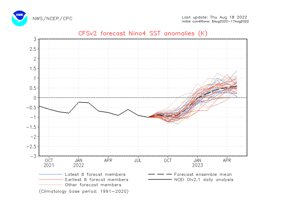
Yeah it looks like the recent rise in subsurface temps is hinting at the dynamical guidance camp (faster decay of the nina) having the right idea rather than the statistical guidance that Keeps the La Niña at low end moderate well into winter. If that is the case, the MEI number will start increasing soon. It will be interesting to see what the September guidance looks like.
-
Imagine if this storm hit on a day when the temperature was 40-50 degrees cooler…. Some areas in Rhode Island had 9 inches today…. of RAIN.
-
There was an event in 2013 where the European model insisted on there being potential for a massive blizzard a week out. I pulled multiple all nighters tracking that due to how much snow the euro was projecting, I had never seen anything like it (was fairly new to tracking and we came off a really mild winter). The gfs disagreed, but the Euro didn’t back down. The euro had multiple runs in a row bringing a monster blizzard with feet of snow to the area. Eventually the other models realized that that slow moving Miller B low wasn’t going out to sea, but it was going to undergo rapid cyclogenesis and come up the coast. The Euro nailed what ended up becoming the historic Feb 2013 blizzard (Nemo) a week out.
-
Yeah it was bad for most areas. My area did decent (mostly due to the monster blizzard in late Jan, 20 inches here) but areas to the north and west didnt which is unusual for la ninas. It looked like a great pattern was coming in on the models, but then winter just kinda died after that. A lot depends on what the polar vortex does, last year it deepened to record strength so even just an average polar vortex would be an improvement.
-
The crazy thing is the snowiest month in history in eastern mass was a raging +NAO, yet we still got buried with the pacific cooperating well (weak west based El Niño in action). I’m hoping the dynamical guidance is onto something about the rapid decay of the Nina if we get a positive NAO again. I know you mentioned how the active sun and quiet tropics this year favors a positive NAO this winter. If the NAO is positive a weaker Nina or even enso neutral instead of moderate would be better for us. It seems like with ninas (especially stronger ones) we are more reliant on NAO help than ninos. We haven’t had a big December in a while so I’m hoping some of those analogs you mentioned pan out (average ish winter with a big December). We haven’t had a big December in a while, so it would be cool to have a big December nor’easter this year. Looks like while we aren’t looking at anything near 2014-2015, we aren’t looking at a 2011-2012 type winter either. Maybe something similar to last year but a bit more in December, less in Jan?
-
Damn that bass is massive, how many inches was it?
-
I like the ridge out west, the NAO looks positive but only weakly positive. That might even be a good thing with the Euro killing off the nina. I don’t get why there is also a ridge in the east, which is concerning and would be really bad for us. The NAO is positive yeah but doesn’t look like a raging strong polar vortex pattern. To my untrained eye that almost looks like a strong El Niño pattern with a raging pacific jet, yet El Niño is nowhere to be found.
-
What are you thinking this Nina peaks at? Maybe low end moderate, similar strength to last year then weakens by late fall? Or do you think the models could be missing something and the Nina becomes strong? The disconnect between model forecasts and subsurface data, MEI ect is interesting.
-
Oh no not Miller Asshole…… Id rather take my chances with a Nina even moderate strength (more Miller Bs). A 2009-2010 pattern with better luck could be decent for us, not like a 2015-2016 pattern with a super nino furnace winter. Id rather take my chances on a higher ceiling pattern in SNE like 2014-2015, 2010-2011 ect though. Oof at that storm where NYC got buried 2 feet while it rained here, that’s some tough luck. Other parts of the board would probably be happy with that 2009-2010 type of pattern (maybe Southern CT, RI ect?), but I am greedy, I want all the snow lol.
-
If that’s true hopefully we cash in this winter. Moderate can be decent but isn’t strong nino really bad in SNE? Or would that not really apply in this scenario because stronger ninos are usually east based and this one would be modoki?
-
Hopefully we get a nino next year and it stays weak
-
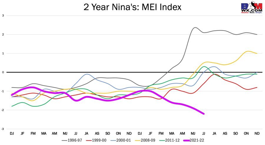
The MEI index of -2.2 for the June July period is reaching record territory. The only time it was lower was during the strong La Niña in 2010-2011. This event is forecast to be much different, with the CFSv2 having us at moderate La Niña (-1) in November, but Enso neutral in January (0). It doesn’t say anything about the MEI, but I would think that would rapidly decline as well. With how sharp the models are saying the rise in temp in the enso 3.4 region will be, if that is real we may even see something like going from La Niña in December to warm neutral or weak Nino by Feb. I’ve never heard of something like that happening, a La Niña the first half of winter an El Niño the 2nd half (some of the more aggressive guidance has that, most dont quite get to nino territory though). Other guidance is hinting at this rapid weakening of the Nina as well so it probably is real to an extent.
-
Interesting looks like we are in unprecedented territory. The La Niña isn’t all that strong but the MEI index is going ballistic.
-
If la ninas are more favorable early in the season, since this Nina is expected to peak early and rapidly weaken in the back half of winter, could that mean we get the big Nina first half but avoid the unfavorable Nina Feb-March? Last years Nina strengthened deep into the winter where as this Nina is expected to be weak in the early half of winter and potentially non existent the second half (enso neutral).
-
Oof if the polar vortex is record strength like last year that is a really bad sign for winter. I remember you saying the nina going east based saved us from a 2011-2012 type outcome with all the cold locked up over the North Pole. I see why you were hoping for an El Niño now, if the NAO is positive it’s less of a death sentence in a nino. Hell, wasn’t the nao raging positive during the 2014-2015 snow blitz? Hopefully the pacific cooperates and we can at least get a decent winter even if it isn’t anything crazy even with an unfavorable polar vortex.
-
It’s very unlikely based off the current guidance but how would it impact the winter outlook if the Nina grew to record strength, but became strongly east based? Is strong/east based a better outcome than weak/west based?
-
Do you think the sun is going to go ballistic again or cooperate more this year? If the sun stays quiet this winter the polar vortex should be a lot weaker. It deepened to record strength last year so even if it doesn’t shatter into a billion pieces I would think there is a good chance the polar vortex will be more favorable.
-
To get a big winter in SNE we need more Miller Bs and less Miller As (as Ray likes to call it, Miller Asshole).
-
I see. The models are projecting La Niña to be weak so even you guys farther south have a decent chance. A couple years ago people used the solar min to argue winter would be big, we didn’t get a big winter (maybe some local areas did well, but a widespread big winter like 95-96, 10-11 ect was nowhere to be found). Maybe there is a lag and the run of big winters with -nao that were supposed to come with the solar min are coming up now.
-
If Nina becomes more east based the winter could be great. I know things don’t look good right now but it’s too early to write a big winter off, still a lot of time for things to change. Doesnt NYC and the northern mid Atlantic do well in ninas? I like the look of things for my area but if I’m remembering correctly even NYC does well in weak and moderate ninas.
-
Too early to tell
-
It doesn’t look great right now but I’m not ready to write off a big winter just yet. I wasn’t on the board back then but going into the 2010-2011 winter I can’t imagine people were very optimistic. That year the La Niña was really strong and central based, and the MEI was extremely high which indicates la nina was coupled and dominating the pattern. Hopefully the polar vortex is weak this winter. This is a different pattern of course, but at least it’s not a moderate to strong nino.
-
What are some possible wildcards to look for if looking for a big winter in eastern mass this year?


