George001
-
Posts
6,996 -
Joined
-
Last visited
Content Type
Profiles
Blogs
Forums
American Weather
Media Demo
Store
Gallery
Everything posted by George001
-
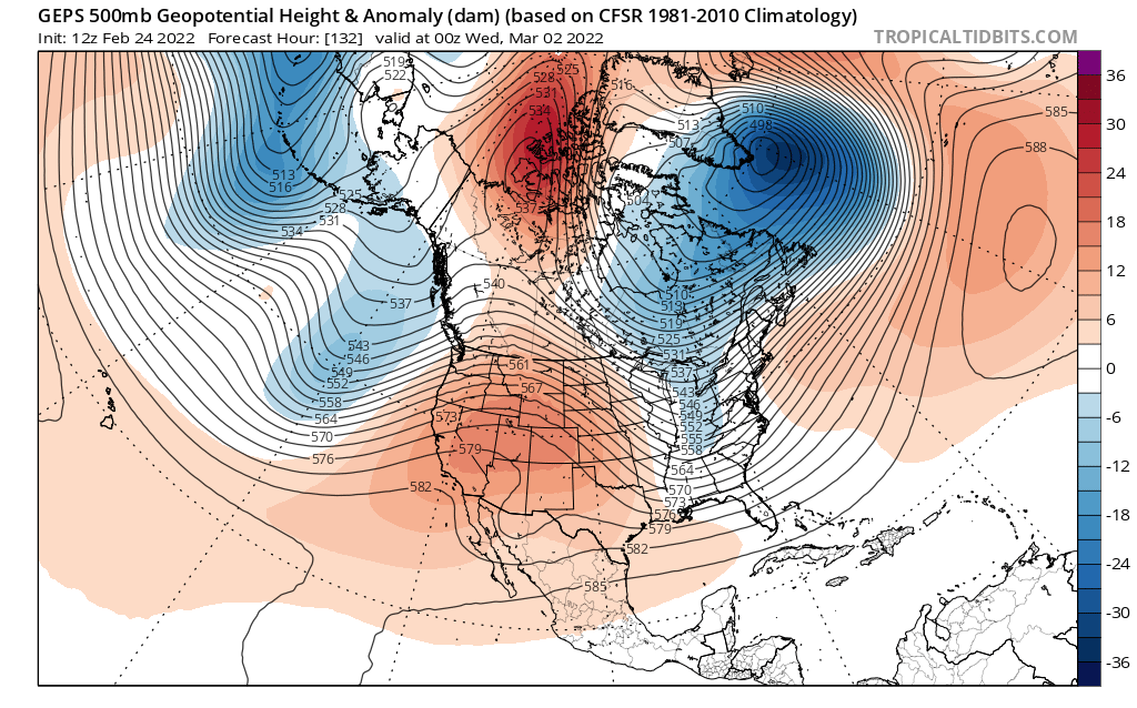
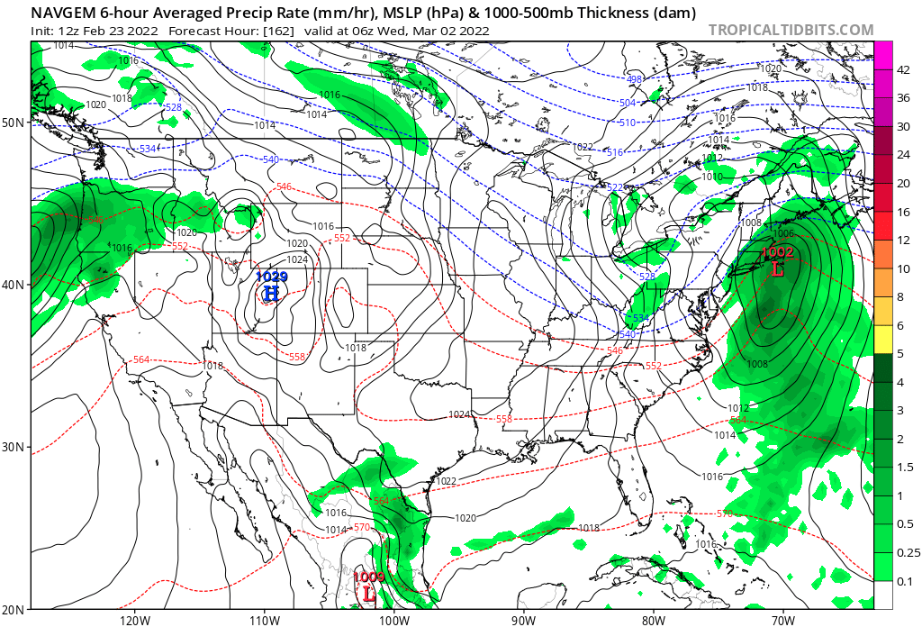
March 3rd is a legitimate threat. Ensembles have a signal (Miller b nor’easter/blizzard threat). Still need to see improvements with the ridge out west though.
-
Nice, that would give us a shot at a big one before spring.
-
Geps looks interesting for early March. Eps a little flatter with the ridge so the energy doesn’t dig enough. If we can get the western ridge to amplify a bit more and link up with the ridge over the north pole, we could see a low appear out of nowhere on the op runs. Feb 28th threat looks dead.

-

Winter storm for the 25th of February is imminent.
George001 replied to Typhoon Tip's topic in New England
True, but there is a big difference between what the globals and mesoscale models have. Globals are lower with around .8-1 inches of qpf vs like 1.3 to 1.5 inches on the more aggressive mesoscale models. I’m expecting a big shift towards more qpf at 0z, and for the qpf to verify for the most aggressive guidance. -
Winter storm for the 25th of February is imminent.
George001 replied to Typhoon Tip's topic in New England
will it be all snow? Maybe not, but that’s an awful lot of moisture. There is every reason to lean high with QPF. A clash of incredibly mild air, the airmass to the south is the same airmass that brought us record warmth yesterday. Then we have a high to the north with arctic air funneling in. I’m convinced that this isn’t a normal overrunning setup, due to the magnitude of the thermal gradient (that meoscale models would be able to do better with), qpf will increase a lot more than what the global models have. Someone up north is going to get buried. South of the pike, it’s more dicey, we are gonna need to rely on dynamic cooling to offset the warm nose aloft.
-
Winter storm for the 25th of February is imminent.
George001 replied to Typhoon Tip's topic in New England
Nah take em up. The low isn’t going to ram into the high like the nam and rgem think, I don’t buy that at all, it’s going to redevelop and turn into a Miller B. -
Winter storm for the 25th of February is imminent.
George001 replied to Typhoon Tip's topic in New England
After seeing all those model runs with 10+ here 6-8 would be a let down. I hope that’s wrong. -
Winter storm for the 25th of February is imminent.
George001 replied to Typhoon Tip's topic in New England
If it’s further north wouldnt it be more amped? I haven’t really noticed any trends, tucked south earlier and back north a bit tonight. -
Canadian close for the 3rd
-
Winter storm for the 25th of February is imminent.
George001 replied to Typhoon Tip's topic in New England
What’s the farthest north you guys think this can go at this point? Guidance has been fairly steady the past couple of days. -
Winter storm for the 25th of February is imminent.
George001 replied to Typhoon Tip's topic in New England
No changes to this, I’m sticking to my guns. Euro has the right idea imo -
Winter storm for the 25th of February is imminent.
George001 replied to Typhoon Tip's topic in New England
Gfs is not part of the big 3. My blend right now is: Navy: 99 Euro: .75 Canadian: .25 -
Winter storm for the 25th of February is imminent.
George001 replied to Typhoon Tip's topic in New England
Nam is the outlier, probably will correct south in line with other guidance tomorrow. -
Winter storm for the 25th of February is imminent.
George001 replied to Typhoon Tip's topic in New England
Ignoring the euro this close in? That’s not a great idea. Could it tick 10 or 20 miles north? Sure. 100 miles though, with a strong high to the north? Nah. -
Overrunning/swfe/Miller B look?
-
NAVY ON BOARD!

-
Enjoy your foot.
-
Winter storm for the 25th of February is imminent.
George001 replied to Typhoon Tip's topic in New England
I know ratios won’t be great on the first part of the storm, but what about the reach around at the end? Possible positive bust there? -
Winter storm for the 25th of February is imminent.
George001 replied to Typhoon Tip's topic in New England
That gives me 16 inches wow (I know, I’m probably not going to actually get that much but even if you cut it in half that’s still a good storm for us) -
64 degrees right now and under a winter storm watch
-
Phase 5 is cold in March, and I have also read that higher amplitude MJO waves over the maritime continent support a pattern that would put pressure on the polar vortex, leading to an increased chance of a disruption or split. This could pay off big time during the second half of the month and possibly even early April.
-
Winter storm for the 25th of February is imminent.
George001 replied to Typhoon Tip's topic in New England
Wow that’s juiced up -
Winter storm for the 25th of February is imminent.
George001 replied to Typhoon Tip's topic in New England
high QPF lower ratios storm, leading to a foot of slop? -
Winter storm for the 25th of February is imminent.
George001 replied to Typhoon Tip's topic in New England
That’s a nice map, what software did you use to make that? Im looking to learn how to make my own maps. -
Winter storm for the 25th of February is imminent.
George001 replied to Typhoon Tip's topic in New England
Yeah that looks a lot better than the previous run