George001
-
Posts
6,996 -
Joined
-
Last visited
Content Type
Profiles
Blogs
Forums
American Weather
Media Demo
Store
Gallery
Everything posted by George001
-

Winter storm for the 25th of February is imminent.
George001 replied to Typhoon Tip's topic in New England
What about Feb 2nd 2015? It looks like this one is turning into a Miller B like that one was. -
Mid Atlantic is probably cooked with that look but it’s good for us since we are farther north. The se ridge prevent suppression, mid Atlantic rains while we get buried.
-
Overrunning to coastal?
-
Winter storm for the 25th of February is imminent.
George001 replied to Typhoon Tip's topic in New England
New euro looks a little colder, primary doesn’t drive as far NW and a little more aggressive with the secondary redevelopment (Miller B).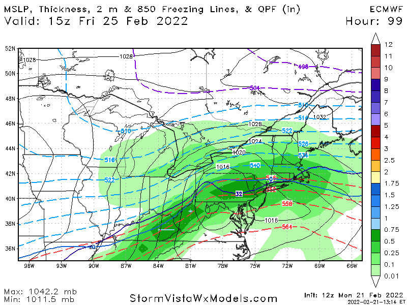
-
Winter storm for the 25th of February is imminent.
George001 replied to Typhoon Tip's topic in New England
Sorry for your loss my man, that sucks. -
Winter storm for the 25th of February is imminent.
George001 replied to Typhoon Tip's topic in New England
I buy that qpf, not sure how much is snow but I do think the models will trend more towards and earlier transfer and stronger secondary low. Also, can’t it snow east of the mid level lows? It did in the March 2017 storm with the mid levels way west. -
Winter storm for the 25th of February is imminent.
George001 replied to Typhoon Tip's topic in New England
Absolutely terrible model, Euro way more consistent. -
Winter storm for the 25th of February is imminent.
George001 replied to Typhoon Tip's topic in New England
I agree with this. Our area south of the pike we probably won’t stay snow the whole storm, but we will get significant front end before any changeover. -
Winter storm for the 25th of February is imminent.
George001 replied to Typhoon Tip's topic in New England
Euro and Canadian on board for 8-12 inches mid CT-RI north -
Winter storm for the 25th of February is imminent.
George001 replied to Typhoon Tip's topic in New England
Holy shit that’s amazing up to 10 inches for my area -
Winter storm for the 25th of February is imminent.
George001 replied to Typhoon Tip's topic in New England
Even if this doesn’t turn into a full blown Miller B, the models aren’t really showing much of a dry slot. A dry slot shutting off the precip early would lead to lower snow totals like some of the earlier Euro runs that maxed out at 6-7 inches. -
Winter storm for the 25th of February is imminent.
George001 replied to Typhoon Tip's topic in New England
Yeah my earlier thoughts of someone possibly getting 18 is a long shot. The kuchera maps would show more but like you guys were saying earlier with the mid levels not being great those aren’t the way to go. The Canadian looked a little more aggressive with the secondary redevelopment which is a good sign. -
Winter storm for the 25th of February is imminent.
George001 replied to Typhoon Tip's topic in New England
Canadian looks good. Shifted south a bit with the low, widespread 8-12.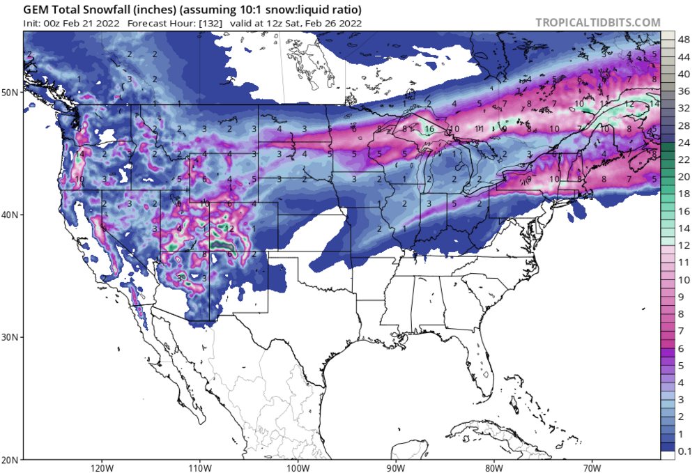
-
Winter storm for the 25th of February is imminent.
George001 replied to Typhoon Tip's topic in New England
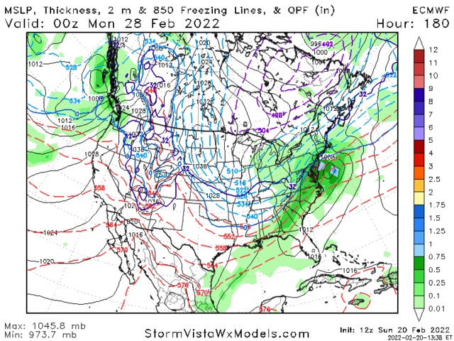
This one is good for us in SNE, but the next one on the 28th your area has a shot too. -
Winter storm for the 25th of February is imminent.
George001 replied to Typhoon Tip's topic in New England
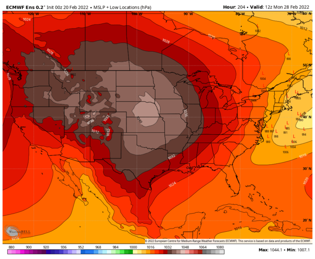
Then we have the possible polar vortex displacement or split, wouldnt do much until like 3rd week of March to early April. If that pans out, it’s very possible we get a big one in that timeframe on top of whatever we get late Feb-early March. -
Winter storm for the 25th of February is imminent.
George001 replied to Typhoon Tip's topic in New England
All it takes is one storm to hit 21 inches, you can get that even in a bad pattern. This upcoming pattern looks great. At least 6-12 is looking likely Friday with possibly more of this trends to more of a Miller B, then a bigger storm threat Feb 28th. If that whiffs, we have more opportunities early March. -
Winter storm for the 25th of February is imminent.
George001 replied to Typhoon Tip's topic in New England
Euro doubled the snow in my area vs 0z. -
Could we use my late winter finale thread for that
-
Winter storm for the 25th of February is imminent.
George001 replied to Typhoon Tip's topic in New England
Mid levels trending in the right direction -
Looks like we got another threat to track end of Feb after the Friday one.
-
Winter storm for the 25th of February is imminent.
George001 replied to Typhoon Tip's topic in New England
That looks juiced up from previous runs. A foot for areas that stay all snow, and my area looks like a little less (like 7-8) probably due to some mixing at the end. -
Yep, this could easily turn into a Miller B with snowfall totals much higher than typical swfes.
-
I like the Friday threat, but man the following threat looks even better.
-
I was excited for a big threat mid Feb as well, and while it was a respectable storm (ended up with 7-8 inches) it didn’t quite pan out the way I originally thought with the big late Jan type phase. This setup is significantly better than that one. What the late Feb threat has going for it that the mid month didnt is a significantly more poleward western ridge. The pattern was just a bit too progressive for a big phase mid month, but even so we saw that northern energy trend more aggressive like the pattern argued it would. With this threat similar to the last one, the ridge axis is over Idaho, which is slightly west of ideal but very good. It argues that a storm would have plenty of room to trend NW. The main difference is for this threat, we have the ridge out west extending to the north pole, where as the mid month threat only had it extending to NW Canada. This would support a more amplified pattern, giving the northern energy more room to strengthen and dig more SW, likely enough to tap gulf moisture. If this idea is correct, the northern stream would be able to do it on its own. There would be plenty of room for the trough to go negative early enough to bring the storm up the coast (Miller B cyclogenesis). With a northern vort digging that far SW and then strengthening rapidly as it taps gulf moisture, as the trough goes negative there is a decent chance we could see the upper low close off. In my opinion, this threat has a good chance at working out because are less at the mercy of timing since we wouldn’t really need a full phase with a strong piece of southern energy. If we get that it would up the ante even more, but it wouldn’t be necessary. I like this threat even more than I like the Friday storm. Friday is a legitimate threat and I like what I saw from the models tonight. However, it is more thread the needle for a bigger solution and even if everything goes right, the upside is capped somewhat compared to what the ceiling is with the Feb 28 threat.

-
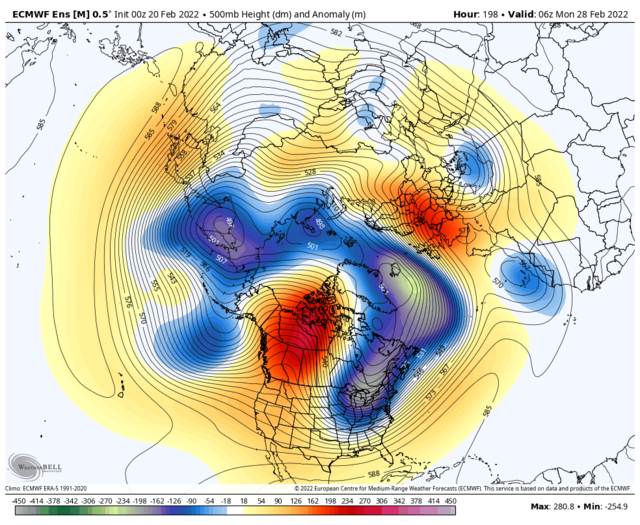
Eps has a low offshore for this time period now. Look how amplified and far west that western ridge is, this threat has big potential. Then we could have another threat March 5-6th or so.