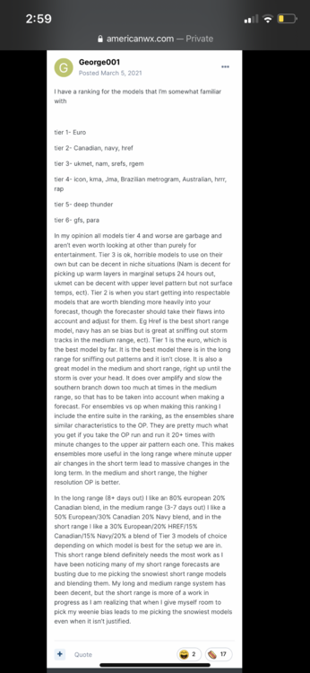
George001
-
Posts
6,996 -
Joined
-
Last visited
Content Type
Profiles
Blogs
Forums
American Weather
Media Demo
Store
Gallery
Everything posted by George001
-
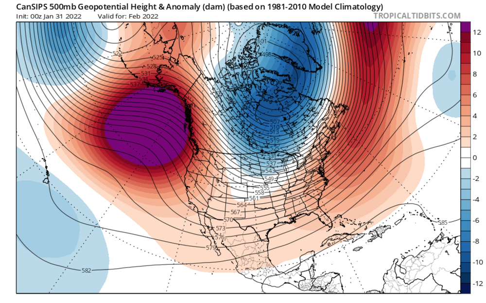
This winter is the opposite of the 2019-2020 winter. The models kept advertising a pattern change to colder weather that winter, and then it would get delayed one week, two weeks, a month, and then the entire winter. This winter, the warm pattern keeps getting delayed. It was late Jan, then early Feb, then mid Feb, and now late Feb. It’s very possible the pattern change to warmth just… doesn’t happen until late March or early April. Patterns can lock in for a long time, like during the fall we were locked in a warm pattern and it didn’t look like it would end. It looked bad in late December, we were finishing up yet another warmer than average month and it didn’t look like things would change. Then we flipped cold the first week of January. It looks like we are locked in a cold, snowy pattern now.
-
This thread is amazing
-
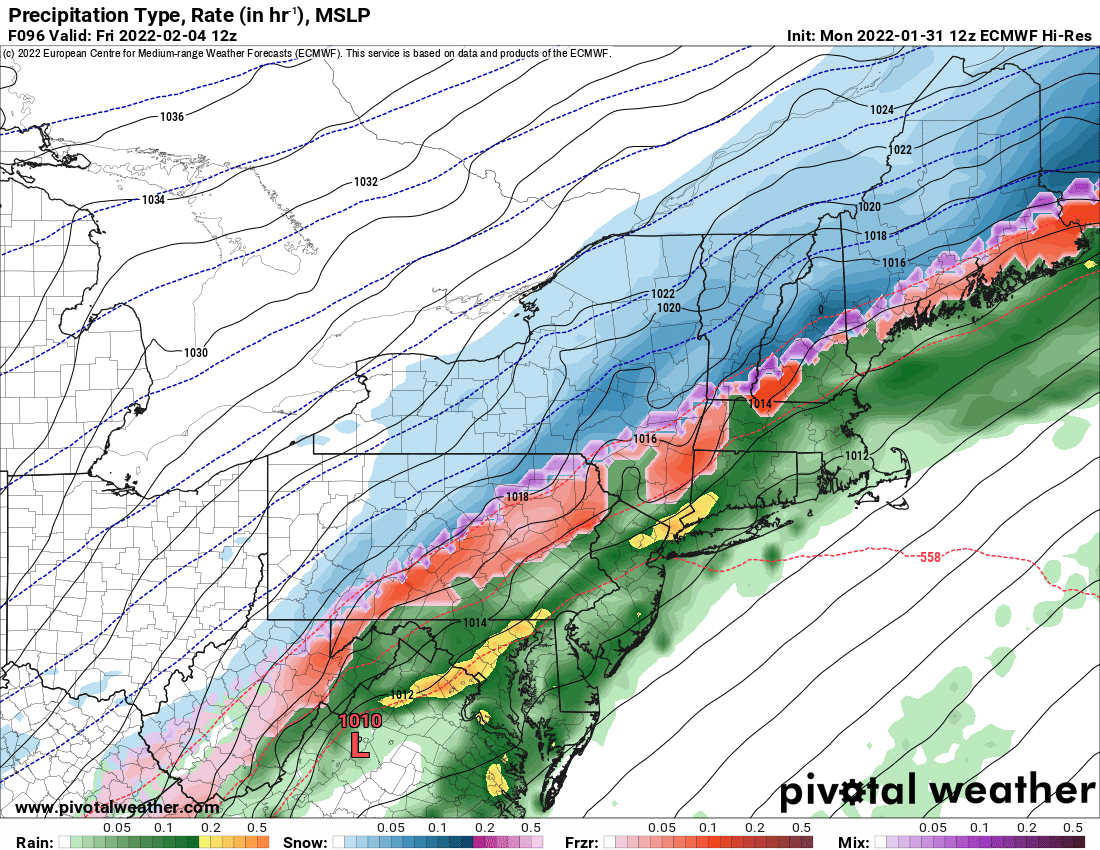
Euro 1 bump away from being a snowstorm down to the south shore and cape cod. Idk if it will happen that way, probably not but damn that is close.
-
I agree with Kevin, I’m convinced we are getting an ice storm. Even the warmer solutions like the Canadian I am convinced are underestimating the cold air press at the surface with a strong high to the north. The models seem to have trended a little slower with the storm which gives the high more time to build in.
-
Holy shit that looks like the pattern we just had for January
-
Your seasonal call is looking pretty good right now, a lot of forecasts I saw went ratter for SNE due to the really warm fall and 2nd year La Niña. Lets hope your March idea ends up being correct, if it does it’s possible your 50-55 inches of snow for Boston ends up a little low.
-
Interesting, Euro looks like it would be a lot of ice and then a few inches of snow around my area and then more snow to the north. I thought for sure the outlier gfs would move to the Euro, but it looks like the goalposts are narrowing, but closer to a colder gfs solution than the warmer ideas. Maybe I should be a little more open minded towards it like many of you said.
-
Interesting look for Feb
-

OBS/DISCO - The Historic James Blizzard of 2022
George001 replied to TalcottWx's topic in New England
Subby zone? I know it’s nice being the jackpot but 17 inches is still alot of snow, even if others got more. It’s not like you only got half a foot or nothing while areas 10-20 miles away got 2 feet. Idk if this will work but it does for me. Every storm I get my 12 inch ruler and measure the snow. If the ruler isn’t enough to measure the snow, I’m very happy with the storm. Any storm that is over a foot is a big storm in my eyes, some years we don’t even get a single storm that drops over a foot of snow. -
Good trends on the models tonight, not there yet but nice to see things trending in the right direction.
-
These types of events tend to screw us south of the pike and are really good CNE and NNE. Im hoping it trends south enough that we can avoid the torch, but not expecting it to be a snowstorm.
-
I’ve read somewhere that models are worse in la ninas. Is this true, and if so how come?
-
It’s nice to have a met on my side.
-
I hope so. I’d like the gfs to be right because it would mean more snow, but I don’t think it will be.
-
Ok anyways back to the storm threat, im going to take this discussion to banter. Euro is still warm but took a step in the right direction. Hopefully it makes a bigger step towards a colder solution at 0z.
-
Well, the gfs gave me like 3 inches of snow and the Euro gave me 2 feet. I got 20 inches, as far west as NYC got like 10 inches. I thought the Euro did a damn good job with the last storm. The gfs was so far east that it was consistently giving NYC nothing and even barely grazing Boston, until it caught on at the end. The Euro was a little too far west, but it was much closer to reality at least with the upper levels than the gfs.
-
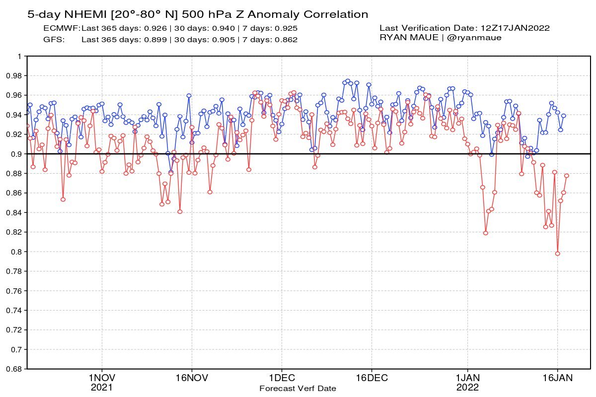
The Canadian is neck and neck with the GFS in terms of verification score. That’s not great, admittedly I expected it to be better, I will have to adjust my system accordingly. However, the Canadian has a consistent bias (it is horrendous with thermals and tends to be overamped with storms). This makes it easier to adjust for the model bias and weigh it accordingly. The GFS is sometimes too amped, sometimes too weak, who the hell knows. How am I supposed to mentally adjust for its biases when it is just… erratic. As expected though, the Euro was by far the best. The Navy’s verification wasn’t on the site I used, but it is likely horrendous.
-
This “dumb kids’” opposition to the gfs is backed up by actual data. Whatever upgrade it got clearly didn’t do shit. The Euro always has been better and I don’t see this changing anytime soon.
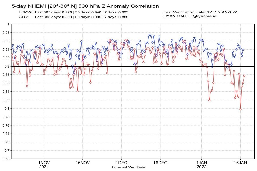
-
I don’t use the gfs and don’t plan on using it anytime soon.
-
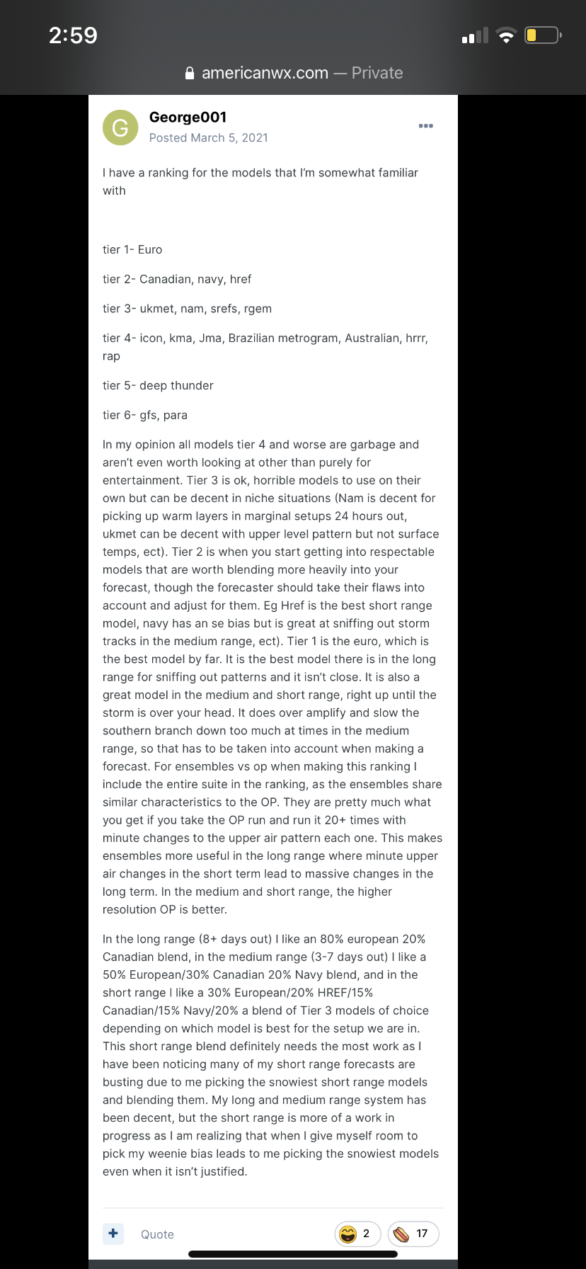
Yeah, that’s not happening. I’m not giving up on the Navy, and I will never use the gfs. I fully understand what you are saying, and I am well aware of the caveats of using the Navy. My rationale for my usage of the big 3 is attached in the photo below. You don’t have to agree with it, but I have been using it and will continue to use it. This system is what I use for every storm, and although I tweak it over time I have not changed the core principles of my system. I will be open to tweaking it, but let me be clear, the big 3 is not going anywhere.
-
Yep exactly. If the Navy isn’t on board, I’m not on board.
-
We need the energy to be held back more. The slower the storm is to come in the more time the high has to build in. I’m not on board for this one yet, need to see the big 3 jump on board before I buy in.
-
For this winter the ratter possibility is gone. Many areas in SNE and the northern mid Atlantic (they have had a surprisingly good winter considering we have a La Niña) have already surpassed or are very close to their seasonal average for the entire winter. Boston’s seasonal average is what like 42-44 inches of snow per winter? Boston is already at 36.5 inches and there are still nearly 2 months left of winter. The question is will this go down as an average-good winter, or a great or even an epic winter?
-
Didn’t he forecast 25 inches of snow in Boston the entire winter? I remember reading that and thinking that was very aggressive, as even if we have a bad pattern the entire winter all it takes is like 2 storms and we break that. The long range guidance looks colder and snowier for Feb now. For a while the guidance was insistent on an extended thaw, I wonder if the volcanic activity has anything to do with the sudden shift colder. I’m not really sure about that, I’ve read mixed things about how it would impact winters in New England.
-
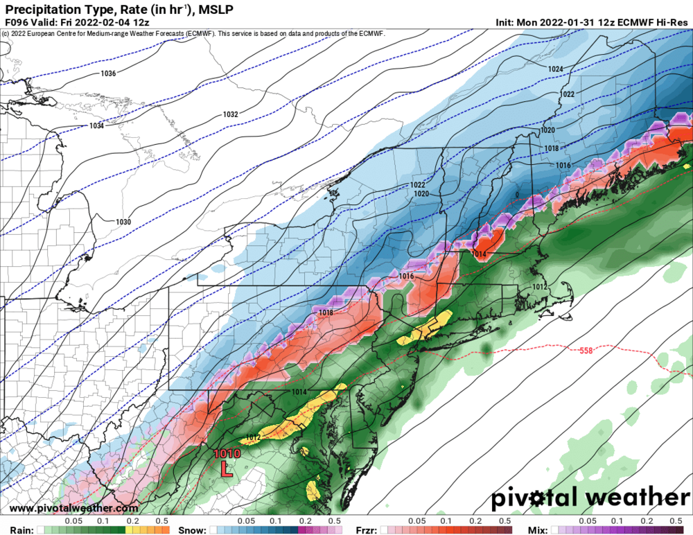
How is the rain snow line so far north with the low that far south?