George001
-
Posts
7,034 -
Joined
-
Last visited
Content Type
Profiles
Blogs
Forums
American Weather
Media Demo
Store
Gallery
Everything posted by George001
-
 I am personally rooting for those 2 bands to combine and form one mega band right over the Foxboro area.
 -
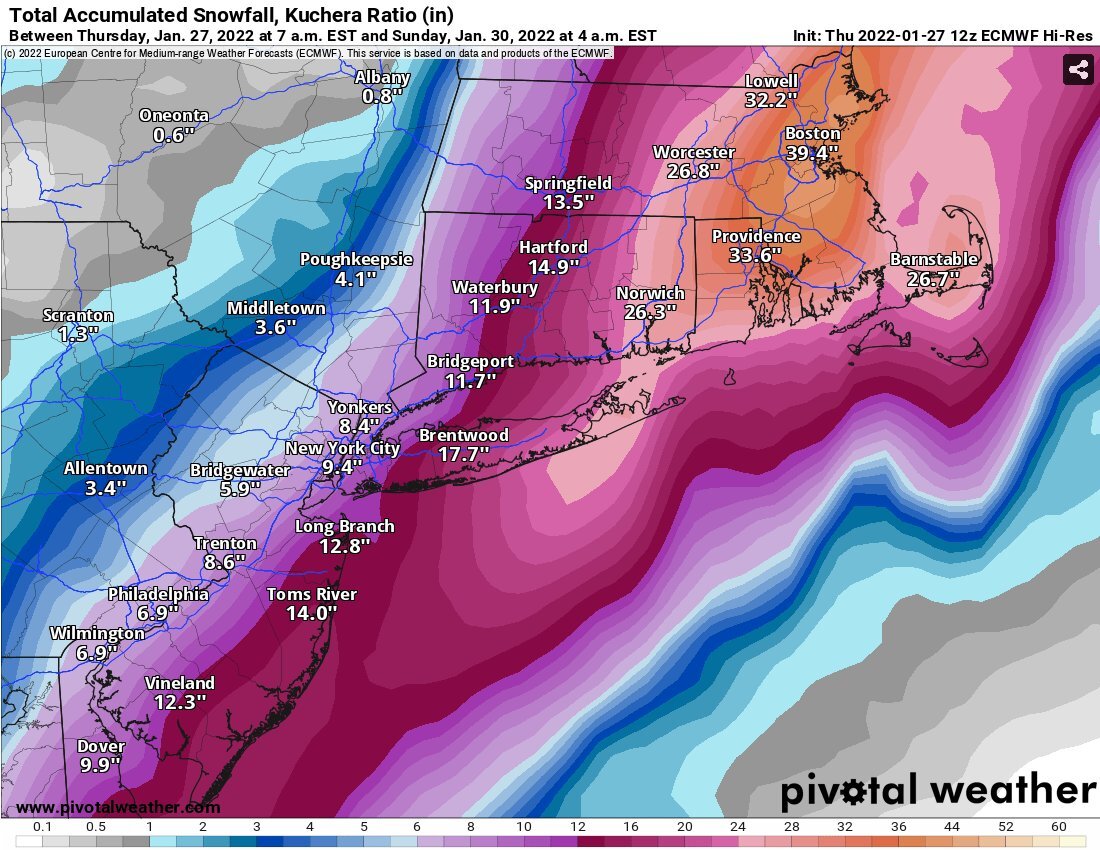
Nearly 4 inches of QPF on the cape… imagine if it came like 20-30 miles west, then we might start seeing 50s and 60s on the kuchera maps
-
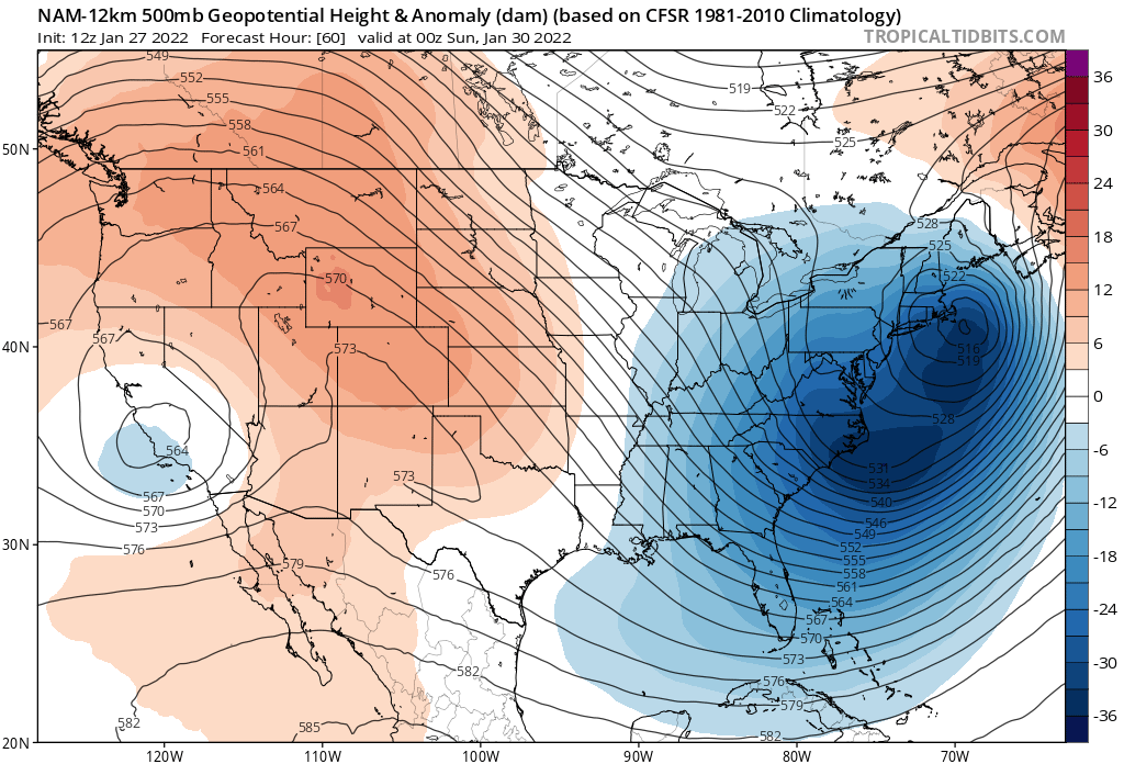
It’s funny how we had North Atlantic blocking in December, nothing. Now we have no blocking at all and are getting a massive blizzard anyways. That ridge out west helped us a lot.
-
This has a chance at being right (my 40 bun post)
-
I initially forecasted 16-20 inches of snow in the Boston area once I saw the Navy jump on board a couple of days ago. Is it possible that I was too…. conservative with my forecast? My forecasts bust all the time, but usually the other way.
-
40 inches of snow in Boston… Boston got that much snow last year the ENTIRE WINTER. Most areas are below average right now (Boston has like 12-13 inches, average around 20 by this time of the year from what I’ve seen), but after this storm it’s very possible Boston is into the 40s or even 50s. Boston averages in low 40s for total snow per winter, and there’s still 2 months left. This is why it’s a good idea to wait even if winters start slow before writing it off. All it takes is one monster blizzard and all of a sudden you go from a shitty winter to a great one. 2012-2013 was like that too, started kinda slow and then got hammered in Feb and March. 2014-2015 started slow as well.

-
Holy shit that’s like a 100 mile shift west, that’s a huge shift this close in. If this is right, with ratios there will be 3+ feet in eastern mass!
-
Euro improved quite a bit over 6z, great sign.
-
I’m with you on this, I don’t use the gfs at all. Gfs = good for shit.
-
models are underestimating the strength of the low if anything. With the frigid arctic air meeting up with the warm gulf and Atlantic moisture, the atmosphere is primed for extreme cyclogenesis as the trough goes negatively tilted. Low closes off leading to a stall and continued deepening. We also have the wildcard, the PV energy. Right now most models aren’t showing this, but the NAM is very close to having yet another northern piece behind it diving in and phasing into the trough as the low stalls so much that it has time to catch up. If this happens, those totals we see on the nam (2-3 feet eastern mass, 1-2 feet NW) would be doubled. Even as is, there are FIVE closed contours at the 500 millibar. As Bernie Rayno talked about in his livestream, a good rule of thumb is a foot for every closed contour of the upper low. This suggests that the QPF and snow output would likely be higher than shown. Lets see what the Euro does at 12z, if it starts trending towards the NAM, this has a very real shot of going from a “once or twice a decade” type storm to a “once or twice a millennium” type storm. That is where we are at right now, the goalposts aren’t 6-12 inches or anything like we see in normal storms, we are talking feet of snow here.
-
If the Euro moves back west there’s a decent chance we see blizzard watches up for eastern mass
-
Sign me up for a repeat of that, I got 2 feet from that storm. Didn’t you get 28+ or something crazy like that? I saw on the maps that NE Mass was in the jackpot. That was a great storm, that was actually the last time that my area was under a blizzard warning.
-
euro a bit east but still great, and the other models went way west. Looks like we are narrowing the goalposts and coming close to a consensus.
-
How does the new navy look? It’s not out on tropical tidbits yet.
-
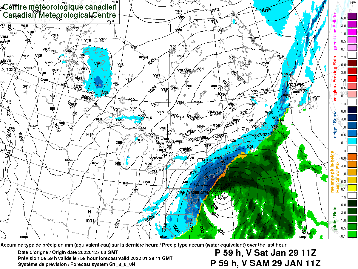
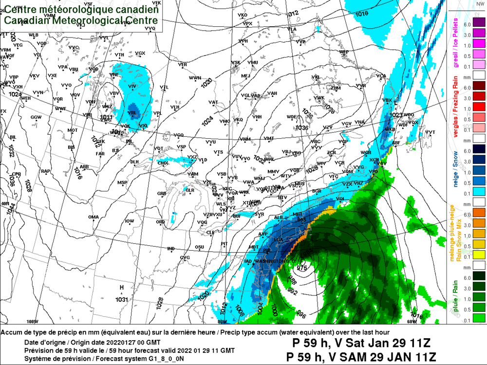
Got it from another board, I’m on a bunch of different weather boards like Anthony is. The Canadian is so far west the outer cape mixes with sleet and rain, like the big runs earlier did.
-
We got the Canadian back, that’s huge.
-
LETS ****ING GO THE CANADIAN HAD A MASSIVE SHIFT WEST!!!!
-
Yep. In the Dec 2020 storm it had Philly and NYC on the northern fringe like 2 days out. The low ended up so far west that it mixed and changed to rain in Philly and mixed in NYC as well (still got 10 inches or so before the changeover).
-
Oh yeah this happens all the time especially with big ones. The Dec 2020 storm was way south and crushed DC like 3 days out, and then the low moved like 500 miles NW, NYC went from being on the NW edge to mixing with sleet after like 10 inches of snow. My area ended up with around 15, and NNE really got hammered, I remember areas in NNE were forecast like 2-4 THE DAY BEFORE the storm and got 40 inches. It’s usually not that extreme, but big changes happen even in the short range.
-
Yep, ejecting more energy like the Euro did. When the Euro went west at 18z it was a great sign. When the Euro sticks to its guns like this 2-3 days out it should not be ignored imo.
-
0z nam is ejecting more energy. Going to be way west with the low.
-
now watch things somehow get really crazy at 0z, imagine if the Canadian has a blizzard, Euro has an inland runner and the low just….. disappears on the Nam. Not out to sea, not weaker, but literally not having a low, just a cold front or something.
-
Someone over at another board compared the obs with the 18z gfs for the energy that eventually becomes our southern energy. It looks like the obs are faster and more east with it, which suggests that the models that are burying the energy are wrong and the Euro has the right idea.
-
Euro if anything looked to improve a bit. Ejected more energy.
-
This is not my map, it was taken from another site. My apologies for not mentioning this with my original post, I don’t want to take credit for a map that isn’t mine.