George001
-
Posts
6,983 -
Joined
-
Last visited
Content Type
Profiles
Blogs
Forums
American Weather
Media Demo
Store
Gallery
Everything posted by George001
-
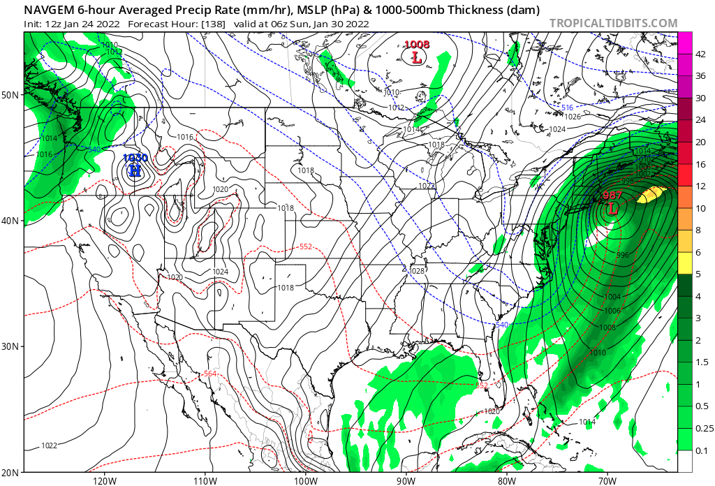
 Ok I’ve seen enough to make my preliminary forecast. Now that the Navy is on board, I am very confident that this low isn’t going to disappear. The question is not going to be out to sea or benchmark blizzard, it’s going to be will it be just inside the benchmark or hug the coast? My Initial thoughts are that the low will hug the coast, going from just east of Long Island, to over the cape cod elbow, and then going into the gulf of Maine, rapidly deepening as it comes up the coast. I am forecasting the low to deepen to the 960s. Since this is a preliminary forecast I am going to start conservative and adjust upwards if needed. NYC: 12-18 Central to eastern long island: 16-20 1-95 corridor, Boston, and interior se ma: 16-20 Worcester: 20-24 Berkshires: 24-28 all of CNE and NNE 20+
 -
Navy is no longer out to sea. Now we have all 3 of the big 3 showing a blizzard. Seeing the Navy this far north adds credibility to the Canadian track.

-
I don’t see why it couldn’t with the high to the north in place and the strength of the low.
-
I completely agree, the Canadian is a great model but it isn’t the best for surface temps. Even with the low coming up over Worcester, due to the high to the north and the strength of the low, I would think the dynamical cooling would offset the less than idea track, allowing it to snow even places that are east of the low.
-
Looks like at least this frame the Boston area is north of the low. It does eventually come up and goes right over the Worcester area, but on tropical tidbits it has the 850mb line offshore. So I would think it’s still heavy snow even areas east of the low.
-
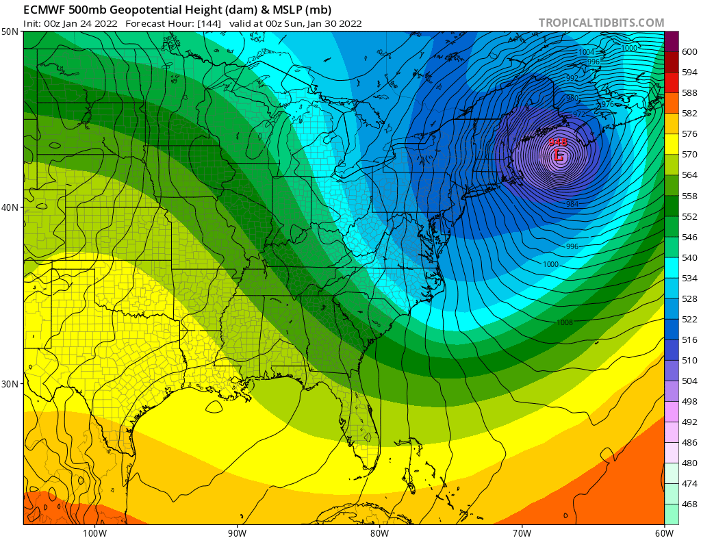
Holy shit, is that the Canadian? Canadian and Euro both have 2ft+ over the area. Low deepens to the 970s on the Canadian and the 950s on the Euro, with blizzard conditions! I think it’s safe to say there will be a monster blizzard somewhere with how far west the models have moved over the last couple of days.
-
What are you thinking about my area, based on what im seeing on the Canadian it looks like my area is right on the line.
-
Imagine if we had the Canadian track with the Euros 940s mb low
-
The Canadian looks really good, I wonder if we would see a rain to snow type scenario with that as the low comes up the coast, due to the more tucked track it brings in some more warm air initally. However, as the low continues to deepen it creates its own cold air via dynamical cooling, changing over many areas in se mass from rain to blizzard conditions. Is this a possibility with the track and strength of the low?
-
I agree. Rain snow line would be confined to the outer cape imo, NW of there blizzard conditions.
-
The pattern doesn’t look great in early Feb but it’s not a torch pattern, still looks like there is cold air on our side of the globe unlike 2011-2012. I’m not going to give up on winter after the pattern change, it can and has snowed in patterns worse than the projected early Feb pattern. I’m not a fan of being negative and downplaying threats 3+ days out, id rather look at the possible upside. That’s part of the fun of tracking.
-
The biggest blizzard in the last decade for my area was Feb 2013, which deepened to 968 mb at its peak. The euro as well as many of its ensembles have the low deepening even more than that. This has the potential to be a historic blizzard, even stronger than Feb 2013 and possibly even Feb 1978. The crazy thing about that Euro run is it wasn’t even a direct hit and still gave eastern mass 2+ feet. Imagine how much it would be with a 940s mb low over Nantucket or the outer cape instead of se of the benchmark!
-
Is this is a Miller A or Miller B? It appears to have both significant northern stream energy and southern stream energy.
-
THE EURO IS A MONSTER BLIZZARD!!! LOW DEEPENS TO THE 940S!

-
It looks like the low goes over the cape, yet the snow output looks a little low. I would think the mean would be 6-8+ even at this lead time all the way down to the canal, how come it’s tainting so far inland? It looks like for the mean the 0 line is offshore.
-
Yeah the low didn’t go quite as far west as I initially thought, it goes over sema not western mass like it appeared on the black and white maps. That would still probably be fine for my area.
-
Yeah, not much elevation here.
-
The Canadian is a legitimate possibility, I’m not going to ignore it. I do think it’s possible the low comes inland a bit, but even if it does, with the rapid deepening and strength of the low, I don’t think the rain snow line would get that far inland due to the dynamical cooling offsetting the more tucked low.
-
If the low closes off and deepens rapidly, wouldn’t it slow down? It would also come west if it does that though.
-
The Canadian is an inland runner, looks like it’s over western mass but the low is very strong. Hopefully it can snow east of the low, is that even possible?
-
I’m very happy with this eps run this far out. Yeah the mean is offshore, but there are quite a few very strong lows closer to the coast. Looks much better than the Euro OP.
-
Euro holds the energy back in the southwest too much so the trough doesn’t go negative early enough. Definitely a concern, but that is one of its biases and hopefully we see the EPS step in the right direction.
-
That’s a great look. Low hugs the coast, but not so much that it drives the rain snow line way inland. That’s blizzard conditions for NYC, Long Island, and all of SNE NW of the rain snow line which would be confined to the outer cape. Even NNE gets hammered since the low is so far west.