George001
-
Posts
6,983 -
Joined
-
Last visited
Content Type
Profiles
Blogs
Forums
American Weather
Media Demo
Store
Gallery
Everything posted by George001
-

Monitoring a potential important TV to East Coastal storm: Jan 17
George001 replied to Typhoon Tip's topic in New England
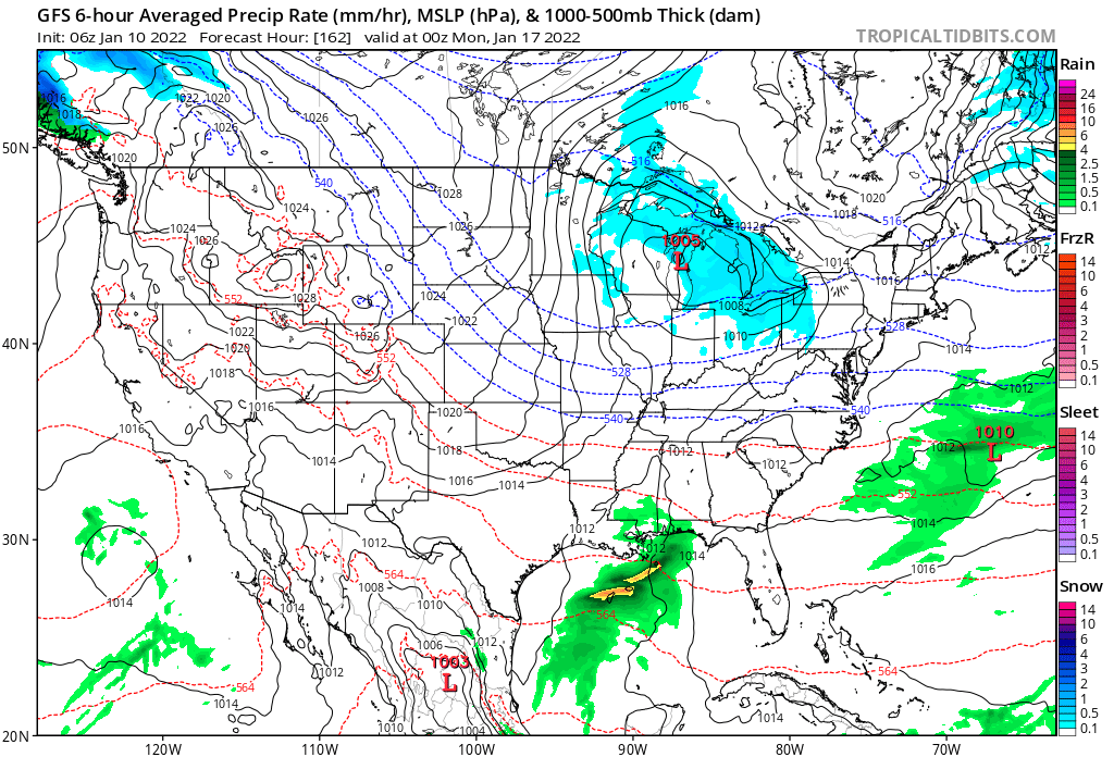
I hope the entire setup shifts away from this Miller A bullshit. We need a Miller B, I hate seeing that on the Canadian guidance. Blend of the Euro Canadian and Navy still looks good though. -
Monitoring a potential important TV to East Coastal storm: Jan 17
George001 replied to Typhoon Tip's topic in New England
the GFS sucks, just 2 and a half days ago it barely even had a low, now it has a blizzard for Montreal.
-
Monitoring a potential important TV to East Coastal storm: Jan 17
George001 replied to Typhoon Tip's topic in New England
Yeah if the navy is more NW than other models that can’t be ignored, it isn’t a useless model. I’d argue it’s alot more useful than the gfs because it has a clear and consistent bias that can be controlled for by the forecaster, where as the gfs is erratic. That’s why when I saw the Navy hugging the coast I started to get really nervous. -
Monitoring a potential important TV to East Coastal storm: Jan 17
George001 replied to Typhoon Tip's topic in New England
Ok if we look at the guidance all we need is a 50 mile shift se on the euro ensemble mean, that’s really not that much. -
Monitoring a potential important TV to East Coastal storm: Jan 17
George001 replied to Typhoon Tip's topic in New England
That’s a good sign considering how far west the Canadian and European guidance were and although it’s a very underrated model it does have a SE bias. Great start to the 12z guidance! -
Monitoring a potential important TV to East Coastal storm: Jan 17
George001 replied to Typhoon Tip's topic in New England
It sucks, I’m losing hope for an all snow event here. Still worth tracking though, even if it turns to rain eventually it’s possible we get a good amount of snow first like March 2017. -
Monitoring a potential important TV to East Coastal storm: Jan 17
George001 replied to Typhoon Tip's topic in New England
For the nor’easter last December the models had the low cutting to Wisconsin at one point with a massive rainstorm in the east. I ended up with around 15 inches in that one with areas NW getting even more (Binghamton NY got 40+ I believe). -
This Friday storm might be closer for us east guys than the Monday one. Definitely something to watch.
-
Monitoring a potential important TV to East Coastal storm: Jan 17
George001 replied to Typhoon Tip's topic in New England
The trends overnight were not good, and it is very possible this low does run inland. But even if it does, we could still see a few inches of snow before a changeover to rain in eastern areas. I’m not going to give up yet though, it’s not an ideal track but at least we have a low. -
Monitoring a potential important TV to East Coastal storm: Jan 17
George001 replied to Typhoon Tip's topic in New England
We need the high pressure to stay rather than move east, I hope that changes. -
Monitoring a potential important TV to East Coastal storm: Jan 17
George001 replied to Typhoon Tip's topic in New England
Didn’t see the precip maps but if it goes from NYC to right over eastern mass that’s a step in the right direction. Still would be rain for my area, but even like 20 miles NW of my area would probably stay snow the whole storm and get a blizzard, rather than being confined to far inland. So far mixed signals, Canadian trended in the wrong direction Euro in the right direction. Models are still struggling with the pattern, hopefully the low doesn’t go inland at all. -
Monitoring a potential important TV to East Coastal storm: Jan 17
George001 replied to Typhoon Tip's topic in New England
The low is a bit se of Nantucket that would be snow all the way to the cape with the airmass in place imo. -
Monitoring a potential important TV to East Coastal storm: Jan 17
George001 replied to Typhoon Tip's topic in New England
Theres so much cold air in place and a massive high to the north, not buying that it just moves outta there like that. GFS sucks, I’m all in with the NAVY. -
Monitoring a potential important TV to East Coastal storm: Jan 17
George001 replied to Typhoon Tip's topic in New England
Yes I would, I never use the GFS. Euro Canadian and Navy are the 3 models I look at mid range. Now my concern is the Euro and Canadian are inland, but the ensembles are farther SE while the navy has a blizzard. There is a lot of cold air in place so as long as the low doesn’t go west of us we should be fine. -
Monitoring a potential important TV to East Coastal storm: Jan 17
George001 replied to Typhoon Tip's topic in New England
Good thing it’s the GFS showing it, the GFS is horrible. -
Monitoring a potential important TV to East Coastal storm: Jan 17
George001 replied to Typhoon Tip's topic in New England
Lol the low is going into Ontario. Maybe we can get it to trend so far west that it gets forced under by the trailing wave and turns into a Miller B instead on the Euro and Canadian guidance? -
Yes I’m a big fan of the navy. Euro, Canadian, Navy are my favorite long range models. I wish the Navy had ensembles like the Euro and Canadian though.
-
Monitoring a potential important TV to East Coastal storm: Jan 17
George001 replied to Typhoon Tip's topic in New England
Wouldn’t that track snow everywhere NW of the low like Jan 2011 due to the airmass in place combined with how strong and wrapped up the storm is? -
I’m on board. The big 3 is on board for a major storm. Canadian and European guidance is a bit inland and turns us to rain, and the Navy has a monster blizzard even on the cape. A blend of the guidance would be a track over the outer canal or so, which would be great for anyone NW of the low.
-
HOLY SHIT LOOK AT THE NAVY! MONSTER BLIZZARD!!!!
-
Yeah I’m rooting for this to morph into a Miller B. I hate Miller As
-
How much wiggle room is there with this one in terms of rain snow lines? I see that the Canadian is also inland so that can’t really be discounted. I know a track over NYC would rain here but if it were to say track over the canal would that be a snowy solution, or would the rain snow line go well inland of where the low is?
-
I agree, there is a lot of cold air in place and also we have North Atlantic blocking for this storm. That will help prevent the low from running inland, I’m more worried about missing to the south.
-
I thought some of the models had that as a Miller B? I hope we trend back to that I hate Miller As, I’m not interested in DC stealing all our snow. We need the evolution of the storm to change again…
-
I’m with you on that, give me a Miller B over Miller A any day, that’s why I’m rooting for the Monday nor’easter over the Friday one.