George001
-
Posts
7,006 -
Joined
-
Last visited
Content Type
Profiles
Blogs
Forums
American Weather
Media Demo
Store
Gallery
Everything posted by George001
-
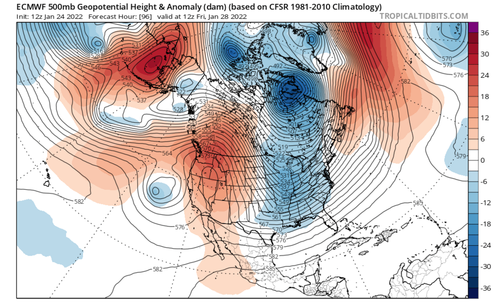
 The nam didn’t bury as much energy out west
 -
That’s a very expansive precip shield
-
Hopefully it trends back towards being a Miller B. Miller asshole finds a way to screw us.
-
I have a question, wasnt the Boxing Day blizzard a Miller A? I would think Feb 2013 would be a better analog because it’s a Miller B.
-
Yeah this looks great. Widespread 20+, it appears the Euro ejects more energy out of the southwest, where as the other models hold more energy back. The more energy that ejects, the higher the ceiling so hopefully we see the other models trend in the right direction with that.
-
the euro is a straight up blizzard
-
If that happens, could we see 4 feet+ jackpots?
-
I agree, if this storm pans out like the models are saying it could be 80 in early Feb for all I care. Also there are signs that the early Feb warmup could be transient based on what I saw on the models with a gradient type pattern setting up.
-
Holy shit that’s over 100 miles west of the last run, the low is much deeper as well. This could be the best run we have seen yet from any model.
-
We got the Canadian back, from looking at the black and white maps, it looks like the low is both west and stronger. Great sign.
-
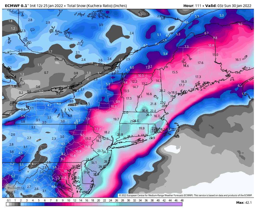
This storm is so big getting 18 inches is considered getting screwed. 18 inches of snow would be the biggest storm I’ve had since March 2018, I’ll take that and run.
-
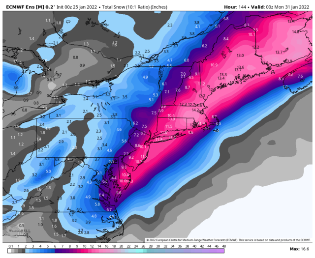
The eps improved. A mean over a foot at 10:1 ratios (would likely be higher).
-
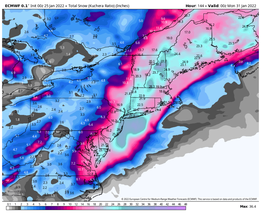
Way underdone, with the low that deep and the stall, I would think it would be a widespread 24+ with the jackpot areas getting 3 feet+ if that were to verify.
-
Even in the screw zones it’s a widespread 18+
-
This type of solution raises the ceiling even more I would think because the low stalls. Ideally it would stall a little more to the ne, but either way its a blizzard.
-
Euro has a 968 mb low inside the benchmark, doesn’t leave behind any of the southern stream energy.
-
That’s a great sign when even the “bad” runs are still giving us in eastern mass a foot.
-
yeah there is a lot of southern energy. The more east solutions seem to be holding the energy back. Hopefully it trends towards a quicker ejection in future runs and no energy is left behind.
-
Ah shit…. We lost the Canadian! Hopefully the ensembles are farther west.
-
I’m not buying the east models at all (nam, gfs, icon). In my opinion there are several factors that favor the western side of the envelope. 1. The ridge axis is over Idaho, which i believe is even more west than the Jan 2015 blizzard. 2. The ensembles are west of the op 3. This is the most important one, the Navy, notorious for having a progressive bias is west of all the models I mentioned above. The rule of thumb I use with the Navy is I straight up ignore all guidance east of it. If the progressive biased Navy thinks this is coming up the coast, in my opinion it probably is. In fact, a blend of the big 3 is west enough that even my area could see precip type issues.
-
It’s funny, having people from all over New England rooting for snow in their backyards, you can get a decent idea of how the models shifted by looking at who is getting excited. With the 1/16 storm I knew my area was cooked when the NNE and more west posters started getting on board. Then I took a look at the models, and yep, drenching rain right over my backyard.