George001
-
Posts
6,975 -
Joined
-
Last visited
Content Type
Profiles
Blogs
Forums
American Weather
Media Demo
Store
Gallery
Everything posted by George001
-
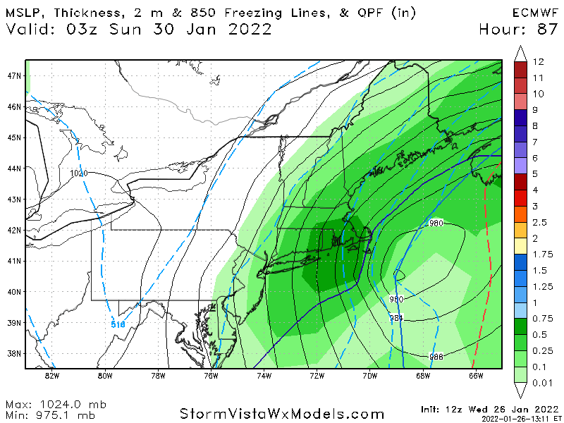
 Navy appears to have shifted west, at h5 it has a closed off low and 2 closed contours instead of only one. Rule of thumb is a foot of a snow for each closed contour (Bernie Rayno talked about it on his livestream, the Euro actually had 3 closed contours). Interestingly the gfs has 3 as well as it goes over the cape and 5 downeast Maine (so it’s surface output is likely bullshit verbatim). The Canadian has only one, which is why it makes sense that the snow totals are lower on that. Nam has 5 closed contours as it crosses over nantucket. Euro last night had 3.
 -
Yeah that looks really bad. Buried the energy out west even more, hopefully it comes back west at 0z.
-
That’s the thing, it’s farther east than the other models, yet even if it were to somehow be right (which is unlikely), it would be underestimating the size of the precip shield. The precip shield would likely be way more expansive with a 959mb low.
-
The Canadian buried more energy so it moved east as a result. Not great, but I’m not giving up on this storm. It still has time to come back west.
-
Imo Euro is Mahomes, Canadian is Allen, Gfs is Hoyer.
-
Canadian is a bit east of the Euro but it is a lot farther west than the Gfs.
-
this is true but it is supported by the Euro, and even if reality is like 50 miles east of this it would still be a huge storm with a 2 ft+ jackpot.
-
Yeah the nam looks like it’s ejecting more energy out west.
-
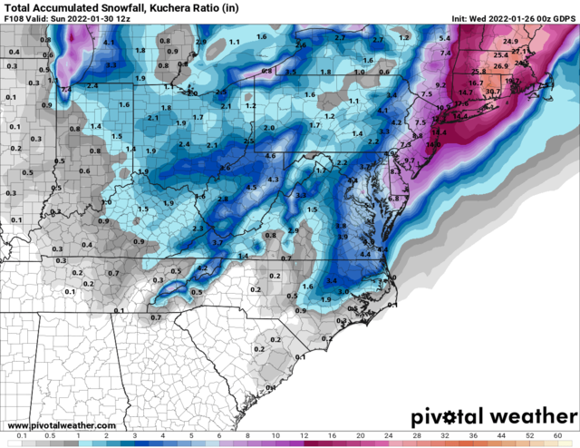
So there’s a chance that the low just…. Disappears? No way! The euro last night had 2-3 feet in eastern mass (with ratios). Based on what I’ve seen on the models I’m convinced my area is going to get hammered with a monster blizzard. 18+ inches with very strong winds.
-
I don’t look at it often but from what I have seen the ukmet tends to have a se bias, and underestimates the strength of lows for storms.
-
The GFS sucks, Euro has been outperforming it all year.
-
somehow the gfs still gives my area a foot despite being so far east with the low.
-
great start to the 0z runs. The Canadian looks like it came west.
-
I can and will. Gfs has had issues with burying the the energy out west all year.
-
It buried the energy out west like the RGEM
-
Yep, the more energy that ejects the better. If the models that eject more energy are right, the low will be stronger and farther west, leading to increased snow and winds. This would result in a monster blizzard.
-
The GEFS said it would be a big snowstorm for my area, but It rained a lot. The GEFS also was out to sea during the Dec 2020 storm, and jumped hundreds of miles west at like 2 days out.
-
Maybe panicked over the 18z gefs run? The east solutions make no sense, gfs products are unreliable. At 500 mb it looked improved, it buried less energy out west.
-
The nam didn’t bury as much energy out west
-
That’s a very expansive precip shield
-
Hopefully it trends back towards being a Miller B. Miller asshole finds a way to screw us.
-
I have a question, wasnt the Boxing Day blizzard a Miller A? I would think Feb 2013 would be a better analog because it’s a Miller B.