

George001
-
Posts
6,983 -
Joined
-
Last visited
Content Type
Profiles
Blogs
Forums
American Weather
Media Demo
Store
Gallery
Everything posted by George001
-
This pattern seems to be wild, not the type of pattern where models will lock onto a big storm a week out and then hold it. In my opinion a big storm is going to pop up out of nowhere sometimes over the next few days on the models. It looks like the massive ocean low that at the moment looks like it’s going to miss to the south is buckling the flow. It looks like there is a strong piece of northern stream energy diving down behind the near miss ocean low on the Canadian, and it appears to be going out to sea harmlessly. On this run it does, but energy coming in behind it is just a few hours too late to phase in and hook that low back in, slamming eastern areas. The low gets all the way down to 975 mb even with a late phase, imagine how strong the low would be with a phase just a few hours earlier!
-
The La Niña is east based, that is usually good for Feb and March. I don’t think this winter is going anywhere, there’s still 2 and a half months left of winter.
-
Considering that this winter got off to a slow start that would suck. I’m rooting for winter until late March
-
Yuck I hope that’s wrong
-
That’s good for Sunday/Monday’s threat
-
Yeah this winter got off to a slow start. The massive trough out west in December ruined what looked like a good pattern, but that looks to be changing soon.
-
I think we’re gonna get one of the 2 Friday or Sunday. Then there will be even more threats after that, this pattern is really good.
-
The Canadian has a Miller B on Sunday, I still think that’s the bigger threat but I’m starting to be more optimistic about the Friday one as well. The Navy is pretty far NW with that one, and that is a huge red flag because the Navy is known for having a SE bias. Id like to see the Euro and Canadian get on board for that as well before I go all in, but it’s worth keeping an eye on.
-
The euro op run was too far south, but it had a big storm which is nice to see this far out, the details can be worked out later. The ensembles improved and look better for our area, the mean at 180 hours is around 4 inches. Considering it has the Thursday storm whiff, that’s all next weekend. A mean of 4 inches that far out for 1 storm is huge. There are a decent amount of close misses on the indies, but several with massive blizzards.
-
an interesting thing I noticed was the catalyst for this upcoming pattern appears to be a really good pacific and occasional blocking but nothing crazy. The NAO may actually average slightly positive for the month, unlike say a 2009-2010 pattern. With how good the pacific looks to be I’m thinking this could actually be good, in that it prevents suppression, leading to a pattern that is better for us than the mid Atlantic like 2014-2015.
-
Wow that’s a bomb alright
-
I’m higher on the Sunday/Monday one because it’s a Miller B and the Thursday/Friday one is a Miller A that originates 100 miles se of the Carolina coast. It could hook back in and whack us, but based on how the pattern looks on the guidance I think it’s going to slip south. The Sunday/Monday one on the other hand….
-
Euro whiffs for the Friday storm but it looks like it’s trying for a Miller B with the next shortwave at hour 144.
-
I get it, sometimes forecasts even ones made by experienced meteorologists bust. Most forecasts had my area getting 3-6/4-8, and my area ended up with a foot. I used to think like you, it seems so easy, meteorologists get paid a lot of money just to be wrong. However, if you look into why and how they end up being wrong, all it takes is one little thing here, there ect and boom the low is 25 miles farther west than expected and the forecast ends up busting. That is within the range of error for model guidance even just a couple days out, and being only that little off in the track of the low is pretty good for 2 days out, but that’s just how the weather works, even 10 miles could be the difference between a few inches and a foot of snow. Im not a met and tried forecasting a few times for fun, and I was way way off. Making forecasts is extremely difficult with almost no room for error, so busts are going to happen. It’s like hitting in baseball, even the best hitters in the league fail 7/10 times! Criticizing meteorologists for busting often and saying they suck, anyone can do it ect is like criticizing the best hitters in the MLB for making an out over half the time. If you do that, you are drastically underestimating how difficult their professions are.
-
What’s interesting is the extended range is trending better as well despite the strong polar vortex. The CFS has shifted from a blowtorch Feb to showing avg temps. There is also some ridging poking into Alaska which hopefully would counteract the limited North Atlantic blocking. We had blocking the entire December and nothing to show for it due to one of the worst pacific patterns on record. There was a massive trough out west.
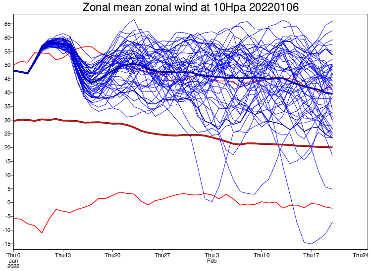
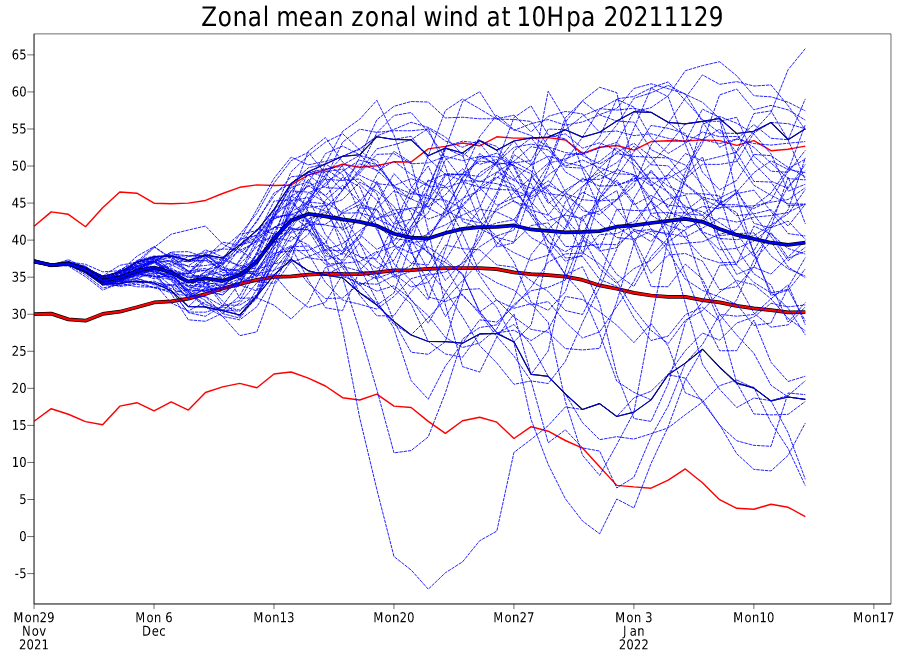
-
The polar vortex is extremely strong and is expected to deepen again, yet the pattern looks great on the models. Looking at this I would think 2011-2012, but that clearly isn’t the case. What’s going on here? I read that although the polar vortex is strong, it isn’t super consolidated, had a minor disruption already, and is expected to have another mid month. Or is it more that the pattern is being driven by other factors like the pacific and MJO? Maybe instead of an extended duration episode of North Atlantic blocking we score via a great pacific and overall positive NAO, but transient periods of blocking?
-
There has been an increase in strength with the La Niña over the past month, enough to be considered a moderate La Niña at -1.0 Celsius on the ONI trimonthly scale. https://origin.cpc.ncep.noaa.gov/products/analysis_monitoring/ensostuff/ONI_v5.php
-
*blizzards
-
If there is any pattern to deliver multiple blizzards to the area, it’s this one.
-
Need to see more support from the big 3 (European, Canadian, Navy). The Navy isn’t in range yet, I could extrapolate it though. Canadian I’d like to see jump on board.
-
The european guidance had a 985 mb low offshore at 216 hours out. Miller B?
-
It’s not on the OP runs yet but the European and Canadian ensembles show what looks like a Miller B around the 16th. The upcoming pattern is looking great, but I’m rooting for Miller Bs instead of Miller As. Miller As can be nice, but it seems like most of our big storms (12+) are Miller Bs.
-
Ended up with 13-14 inches here, double what was forecasted last night.
-
This is a fail, should have stuck to my guns.
-
Snowiest January since 2018, and the great pattern is just getting started based on the long range guidance. This is why its good to let the winter develop and give it a chance before writing it off. When I made that panic room threat things looked bad, but I jumped the gun there.


