George001
-
Posts
6,972 -
Joined
-
Last visited
Content Type
Profiles
Blogs
Forums
American Weather
Media Demo
Store
Gallery
Everything posted by George001
-
Nice
-
No we don’t want models taking steps back, hopefully we see the ensembles start beefing up the low.
-
Euro brought the storm back, It has a low now.

-
Hopefully we get at least one more big one before spring. I wouldn’t say it looks boring the next 2 weeks though, the mid month period has potential. Just need the energy to eject faster. The recent guidance is burying the energy out west, so the storm gets squashed. After that though yeah it looks like it’s going to get mild late Feb. I do think the eps is onto something with the warm up late month.
-
It’s still the first week of Feb there is roughly a month and a half left. It looks like the models support a warmup in late Feb, but who knows how long that will last.
-
Yuck I hope that’s transient
-
There could be a warmup late Feb but even if there is, we don’t know if it’s sustained or not yet. There is still all of March after that.
-
Mid Feb looks promising on the models. March also has a lot of potential if the pattern doesn’t break down.
-
I hope not, that would suck if winter shuts off a month early like last year.
-
 This isn’t a good sign for my area lol
 -
George’s official winter forecast for the Boston area
George001 replied to George001's topic in New England
Mid winter update: Where I went right: The La Niña has been in control and is actively influencing our weather pattern. November was warm, as expected. The first 3 weeks of December I expected to be mild, and it was. My Jan forecast verified well, Jan was cold and had 2 snowstorms, with a monster blizzard at the end of the month. Not quite 40-45 inches in the Boston area, but at 36.2 inches I’ll consider that a good call. Where I went wrong: First of all, I did not assess the enso region correctly (Ray had the right idea here, with a peak of -.9 to -1.1). The La Niña is not strong, it peaked at -1 degrees Celsius, so high end weak/low end moderate, not strong or high end moderate like I thought. However, the La Niña despite not being particularly strong is well coupled and has been influencing our weather pattern. The La Niña is also more east based rather than central based like I initially thought, which is less favorable for December, and more favorable for Feb-March. In my opinion, the misjudgment of the enso was a big reason why my forecast busted (was too cold and snowy) in December, and why it will likely bust in Feb as well (too warm and snowless). January is often very good in Ninas, whether they are strong, weak, east based or central based. Despite this error, I did have the right idea of the enso state being well coupled enough to influence our weather pattern, which is part of why I was so bullish on January. I was also incorrect on my outlook for the polar vortex. I was thinking there would be a major polar vortex disruption in late December, with the polar vortex weakening rapidly before deepening again in Feb. However, the polar vortex has been strong the entire winter, and looks to remain strong in the near future. There were warning signs, such as the lackluster Siberian snowcover during the fall, and the snowcover in North America was very low as well in late fall and early winter. I should give these more weight and less weight to the long range models in the future, as I overestimated how accurate the long range models are for predicting polar vortex strength. However, despite the very strong polar vortex this winter is nowhere near being a ratter. Since the blocking broke down in late December, the NAO has been mostly positive and looks to remain that way on the models for Feb. It is very likely that both Jan and Feb will end up being positive NAO months. This is consistent with the strong polar vortex. This goes into my next point though, despite the polar vortex being strong and the blocking being minimal, the polar vortex isn’t super consolidated. It has been elongated at times, and has been on our side of the globe. So while we aren’t getting blocking, it’s not mild and snowless like many strong polar vortex winters. Also, due to the Nina being more east based than I expected, the pacific pattern has been more favorable than I expected, counteracting the less favorable Atlantic. Areas to the south like Atlantic City have also done much better than I expected, in large part due to an active subtropical jet. I am still thinking my snowfall ranges have a decent chance to verify, though I’m thinking it will be on the lower end. 85 inches in Boston is pushing it, we aren’t really on a 2010-2011 or 2014-2015 track. Those winters both had over 50 inches of snow in Boston by now, we are more on track for a 2017-2018 type of winter (possibly a little better due to us wasting Dec instead of Feb). The risk is the strong polar vortex takes over and winter shuts off in late Feb, or we run the table and have a March 2018 type run that starts a few weeks early (if I remember correctly the March 2018 pattern didn’t break down until like mid April, but climo was too hostile by late March or so to really take advantage of it like we did the first half of the month). Im thinking more something in the middle ends up verifying. We will have to see though, we will know more in late Feb.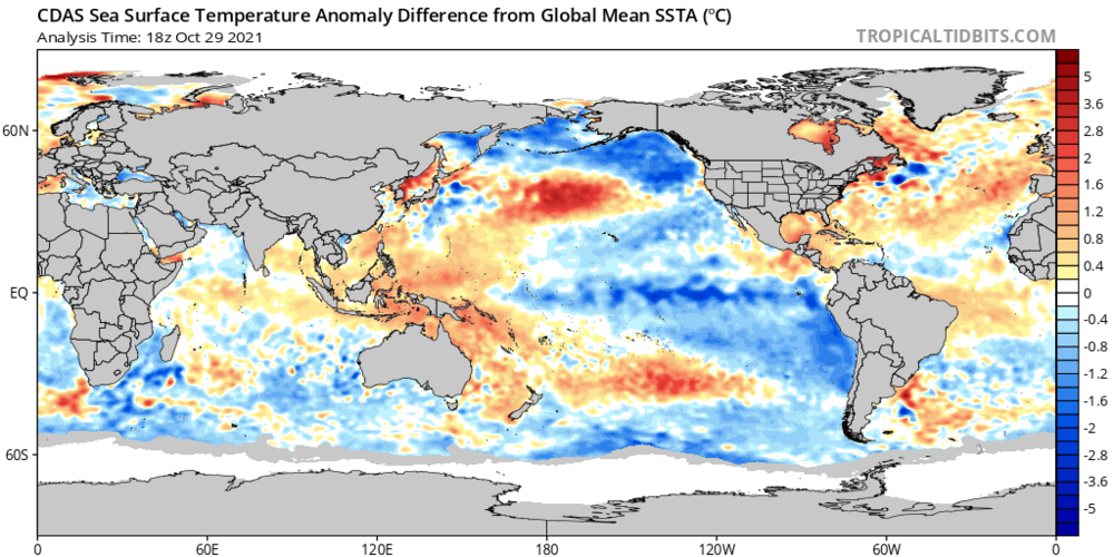
-
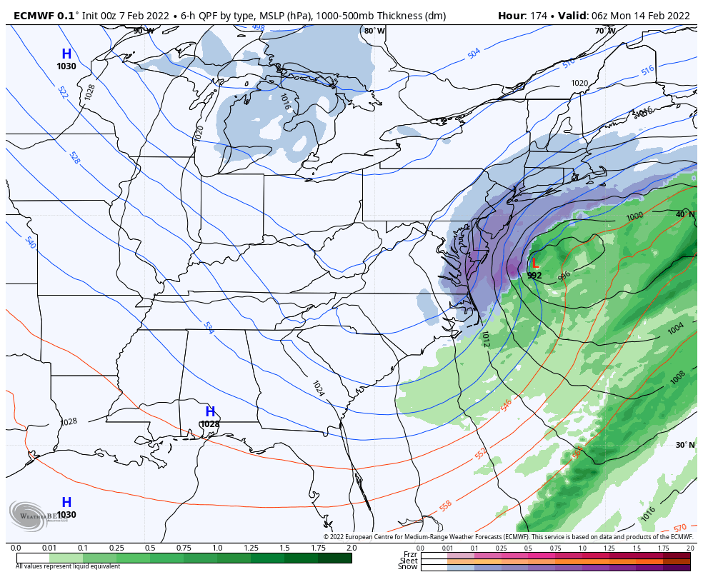
Pattern right before the storm
-
My area has an inch or so of idk what it is, but looks like a combination of sleet, ice, and a bit of snow. Been a while since we had a kitchen sink storm like this.
-
The models have had a storm on and off around the mid Feb timeframe for a bit. I’m hoping to see that signal strengthen on the ensembles especially over the next few days. If we can get the MJO to stall in 3, that would extend our favorable window even longer. In prime snow climo (roughly last week of Jan to like 3rd week of Feb at least for my area), even an extra couple of weeks of a favorable pattern can make a big difference.
-
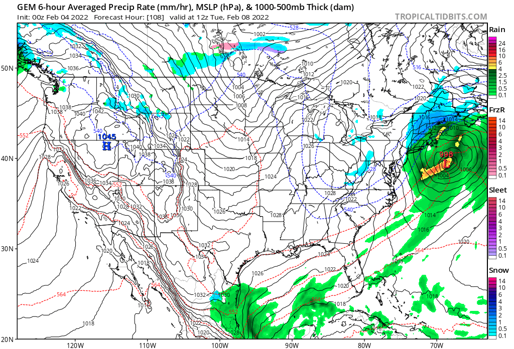
With optimal low location in early Feb? Possibly to start or if the system stays weak, but if the trough goes negative all bets are off. Due to the marginal airmass I would likely start as rain, but the low would then rapidly deepen and then the rain snow line would crash all the way down to Nantucket as the storm creates its own cold air via dynamic cooling. This would lead to possibly a few hours of blizzard conditions in eastern mass after a bit of rain.
-
Yep, I’m on board for this one. That’s a strong southern shortwave right there, just needs to get ahead of the northern stream a little earlier and all of a sudden we have a big storm.
-
The models suggest otherwise. We will probably need to wait a couple weeks before we have another shot at a big one, but the late Jan pattern appears to be reloading by around the 10th or so. Often times the first threat whiffs before the pattern really sets in. I’m seeing several long range mets highlighting mid month for a possible bigger storm threat. We are also seeing the MJO stall in phase 3 rather than go to 4 on the latest guidance. In my winter forecast I called for a mild and snowless Feb, but I strongly believe that will bust.
-
Good low location on the Canadian

-
I disagree. We have seen a trend towards more big ones yes, which explains why seasonal snowfall averages have increased. However, it seems like it’s harder and harder to get marginal systems to go our way. I do think climate change is a big part of this, as the warmer oceans help beef up storms, which helps us get more big ones. However, a warmer background state also works against us in more marginal events where we don’t have those dynamics. Although snowfall averages have increased here, they have decreased in areas to the south. The earth is getting warmer, and the rate of that warmth is accelerating. There’s a reason why every year we hear “this year is a top 10 warmest year on record”. 2021 was tied for the 6th warmest year on record in a goddamn raging La Niña. La Niña is a cyclical weather oscillation that favors COOLER average global temps, yet last year still was one of the warmest on record globally. You aren’t wrong about cyclical weather cycles, but climate change plays a huge role as well, and that role is getting bigger and bigger every year.
-
Yeah things have changed. The short range guidance has moved towards the low moving in faster, thats no good for big snows. The high needs more time to build in.
-
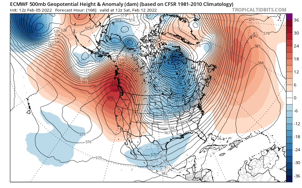
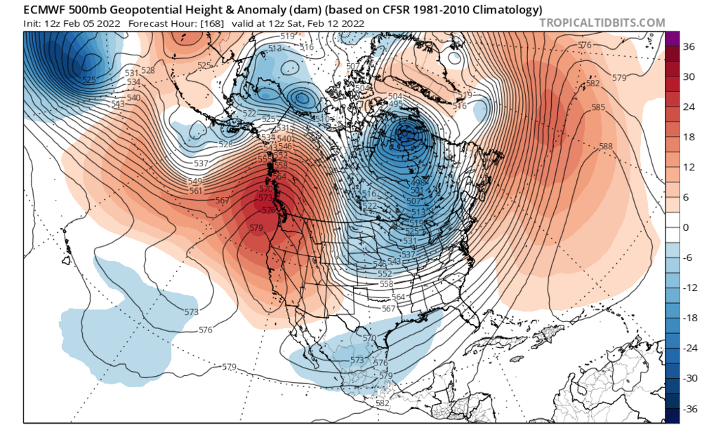
That pattern looks really good, deep trough in the east. Correct me if I’m wrong but this would not be a dry pattern either, due to how far west the western ridge axis is. The Atlantic ridge should help as well.
-
This winter is the opposite of the 2019-2020 winter. The models kept advertising a pattern change to colder weather that winter, and then it would get delayed one week, two weeks, a month, and then the entire winter. This winter, the warm pattern keeps getting delayed. It was late Jan, then early Feb, then mid Feb, and now late Feb. It’s very possible the pattern change to warmth just… doesn’t happen until late March or early April. Patterns can lock in for a long time, like during the fall we were locked in a warm pattern and it didn’t look like it would end. It looked bad in late December, we were finishing up yet another warmer than average month and it didn’t look like things would change. Then we flipped cold the first week of January. It looks like we are locked in a cold, snowy pattern now.
-
This thread is amazing
-
Euro 1 bump away from being a snowstorm down to the south shore and cape cod. Idk if it will happen that way, probably not but damn that is close.
-
I agree with Kevin, I’m convinced we are getting an ice storm. Even the warmer solutions like the Canadian I am convinced are underestimating the cold air press at the surface with a strong high to the north. The models seem to have trended a little slower with the storm which gives the high more time to build in.