Search the Community
Showing results for tags 'multiple storms'.
Found 1 result
-
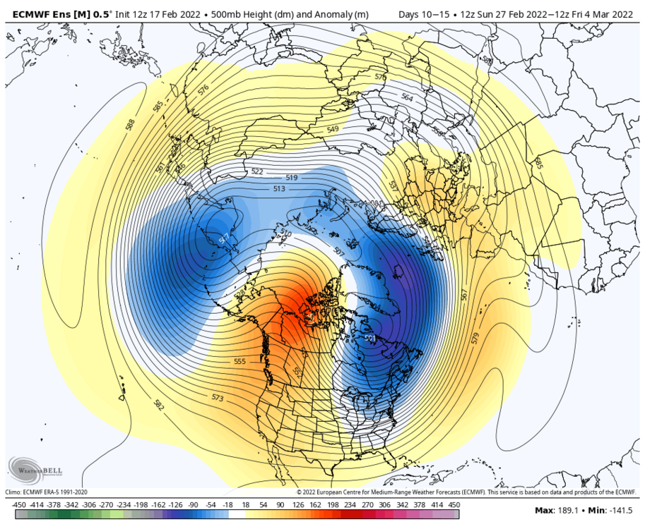
This thread will encompass the late winter to early spring window. The models have shifted away from a mild pattern for late Feb into early March to a much colder and potentially stormy pattern. My early thoughts for the late Feb period is that it does not favor an all snow event for SNE, due to the SE ridge in place and warming mid levels. However, there is a strong high to the north, so I do think there could be a significant (6+) front end before a changeover to sleet or ice. I’d favor north of Boston for the biggest snows, with Boston south getting a decent front end before a changeover. I do not think this will be a huge storm, 6-12 inches. Closer to 6 for the areas that mix and 12 for the areas that stay all snow. Although for the late Feb pattern there aren’t any signs of a huge storm, there is the possibly that if things break right we could get 2 or even 3 waves due to the energy out west ejecting in pieces, not all at once (if it does eject all at once, it would likely cut inland). We do not want a phase here). What once looked like a torch turned into a very interesting period with snow sleet and ice all on the table. Now the period that really interests me is early to mid March. I have read concerns about suppression and have seen comparisons to March 2014, but in my opinion this is unlikely. Why? In 2014, the vortex was over Maine. On the EPS, the vortex is east-central Canada, which is several hundred miles north of 2014. This argues that storms would have more room to come north than 2014. We also have an extremely amplified western ridge axis. The ridge axis is centered over Washington state and is poking up all the way to Alaska. Ideal for east coast cyclogenesis is over Montana, so if anything it’s a little west of ideal. This looks very similar to the Jan pattern but if anything, the western ridge is even more amplified. This suggests that any northern energy has room to dig very far south, enough to tap into gulf moisture and phase with any southern energy available. The biggest and most important difference is it is early March, not early January climo. This is double edged, as the milder late winter waters clashing with the arctic airmass in place would encourage more explosive cyclogenesis, leading to a stronger low and farther NW low. However, if the track is too far NW it wouldn’t take as much to bring in warm air and flood the coast with rain (like the early Feb event last year, where Boston didn’t get much and interior areas got slammed). Rain snow lines are absolutely a concern, so I would like to see a Miller B or hybrid system more so than a Miller A for my area, but either way the potential for a big storm is there. In my opinion, this is the most explosive pattern I have seen since March 2018, and honestly has the potential to be even more explosive than that. We have an extremely amplified and western ridge displaced very far west combined with a piece of the polar vortex over central canada. We also have a weak east based La Niña currently in place. East based La Niña climo tends to be favorable in March, more so than western or central based events. my bold call: for many areas, there will be a storm in early-mid March that ends up being STRONGER than the January blizzard, and delivers even more snow. The question is, what happens in mid to late March? We are seeing signs that the polar vortex could finally start to rapidly weaken, which could lead to this favorable period being extended all the way to early April. If that happens, I believe we will get 2-3 big ones (12+) with possible a couple moderate (6+) ones mixed in as well. That is the upside with this pattern. Will it happen? It may not, but even if it doesn’t I am still convinced that the early-mid March period will deliver, and could even deliver 2 big ones, yes even with a positive NAO. Then we have the mid March to early April period that could be interesting as well. The thing about the near record strong polar vortex we have right now is that when it does get disrupted and is displaced or even split (unlikely, I’m leaning displacement right now), all that cold air bottled up over the North Pole is going to come crashing south. This is an anomalous event, so we could see some crazy ass shit. A lot of you will probably think I’m going off the deep end here, but I’m just gonna say it. I think there will be a window in late March early April, with a much higher probability than normal for an April snowstorm this year. If I’m wrong I’m wrong, but when we combine the already colder than average Canadian airmass in place with a record strong vortex being possibly displaced or split, if it is displaced to this side of the globe, April 1997 becomes an analog (correct me if I am wrong, but I read that this was also a strong PV winter). This does not mean something as extreme, but a muted version of that? Hell yeah! Will the PV be displaced to this side of the globe? It may not, but I believe it will due to the polar vortex having a tendency to elongate and stretch toward this side of the globe this year, sunlike previous strong PV winters like 2020.