vortex95
-
Posts
2,208 -
Joined
Content Type
Profiles
Blogs
Forums
American Weather
Media Demo
Store
Gallery
Everything posted by vortex95
-
It seems over time, the size of warnings has grown, or they are issued earlier. Special marine warnings for Chesapeake Bay this evening, and the line of storms was 1 hr out. No OFB ahead yet either. People are only willing to take so much time out of their day. More is not always better. Say one day we can give a spinner warnings 1 hr ahead. So does that mean people need to go to their basement immediately? That is absurd. And say some do that, and nothing happens (which will for the majority), many will not be happy b/c it is a waste of time. For large venue locations w/ lots of people, yes longer lead times are better, but that's the minority of the time.
-
I get that, but @CoastalWx has no excuse!
-
Excellent shelf cloud visible from College Park now! Too dark for a good still photo tho.
- 2,604 replies
-
- 1
-

-
- severe
- thunderstorms
- (and 7 more)
-
That's what I thought for @CoastalWx when he got his long awaited 6" in Jan -- VIOLENTLY BEAUTIFUL he said. But the NIN "downward spiral" continues I guess despite a solid 25-26 winter.
-
Not me. I've mellowed out. When you are a teenager and once in college just getting to know the real ins and outs, and that period SUX for snow (for me the second half of the 80s), when the train finally came in 1992-93, that gives you perspective, and then after something like 95-96 and to top it off w/ one of the most wild blizzards ever in 1997 (the "freak the public out" off season events do it for me!), that made up for all the "bad times." And it just stayed epic, w/ the absolute pinnacle Jan-Feb 2015. @CoastalWxwas old enough to know how the second half of the 80s were Ask him how many times how woke up to sunny conditions and went, "WHAT HAPPENED TO MY 4-8" OF BACKLASH?!" And even though he had to wait a bit longer than me b/c Dec 11-12, 1992 was a royal shaft in Brockton for snow, it all corrected itself soon enough, and for *everyone.* Even when a gap occurs like the 4 years until this past Jan, and then two 20"+ storms in his backyard? Sorry, I don't want to hear it!
-
I recall not so long ago, you'd get a PT when there was a sharp gradient of snow/no snow on the S Shore, and snowfall was only 1". And I said, "you really are getting excited about seeing that?" And you fired back saying how fascinating it was seeing the sharp gradient. Guess that weenie I once knew is long gone!
-
Taking it up a notch, you get ppl like @CoastalWx who say MEH and whine if every storm is not a blockbuster. Look at his post just from a few hours ago. Whining basically b/c "I have seen it all and am jaded." And now takes the figurative position, "I only want HOME RUNS, singles and doubles SUX!"
-
You should go live EFFINGham NH, at least you'd see a lot more SN.
-
Instead of PD2 we could call it PS2 (Perfect Storm 2)!
-
A classic GIF from "Midlo" that fits this!

-
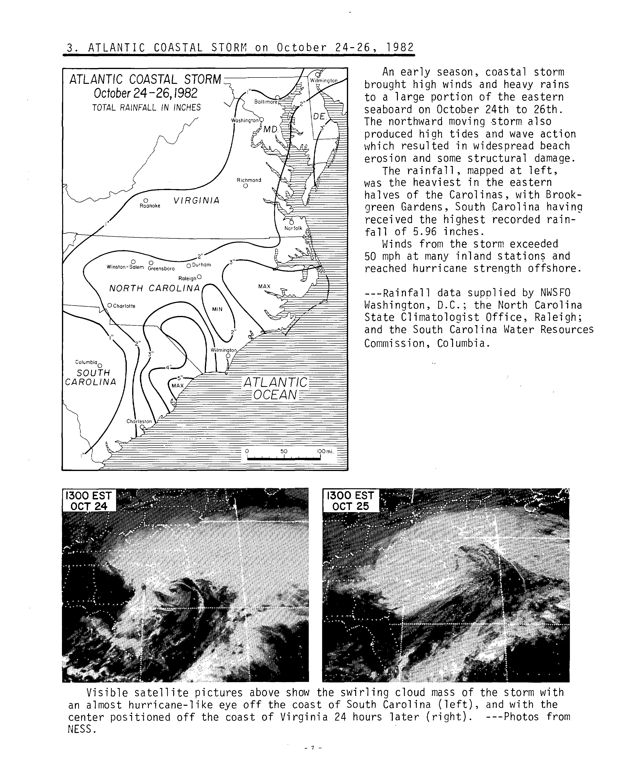
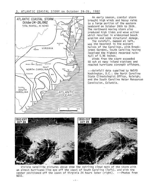
Here's @GaWx big Oct 1982 storm. This page from Storm Data I recall well back in the day and I was awed by the line "an almost hurricane-like eye off the coast of SC." So what is fcst down the road is in-line w/ previous very strong El Ninos. All this focus on how unusual or "unpredictable" the wx is for very strong El Nino (or wx in general), when in reality, the wx that happens within this type of El Nino is normal for it based on previous events! https://www.ncei.noaa.gov/gibbs/image/GOE-5/IR/1982-10-24-21
-
Then there's the MECS S+ part, at least for the Mid-Atlantic. Feb 1983 and Jan 2016. So the 4 very strong El Ninos since 1950, its 50-50 for that. And for epic storms in general, the Jan 1998 "super" ZR storm NNE and srn Quebec! Also, for a more localized bonus S+ events (the one @CoastalWx could not BELIEVE occurred, esp. since he got stiffed in GHG/Brockton), was the Dec 23, 1997 BOS Herald front page "THEY BLEW IT!" w/ mug shorts of the local BOS OCMs. At most 4-8" fcst for SNE w/ a chance of mix, and it ended up 12-24" of super wet glop. The one when Ayer MA got SNOINCR 8 and it was then realized how important the DGZ temps/saturate was (watershed weenie fcst moment for @CoastalWx) That explained the MONSTA flakes and how a kind MEH sfc low could do such "KRAZEE" snowfall rates! So really from the above and what @GaWxnoted, "KEWL TYMES" ahead for the E Coast!
-
Unquestionably, higher surges have occurred, even with the top 10 list given. We just don't have tide gauges dense enough or a long enough period of record, and there are very localized areas when the surge is funneled so it can get much higher than the mean (small inlets or rivers that narrow as they go inland). Ike was unique in the fact when it was at 22.7N/83.3W, it was 966 mb but "only" 65 kt winds (from recon). I think that is lowest pressure for such low winds for a HU S of 25N in the Atlantic. Standard W/PR for 966 mb is about 95 kt, but it is not one-size-fits-all. Normally you'd see such W/PR disparity much farther N where cooler SSTs, baroclinic process, and increased Coriolis decreases winds for a given pressure compared to the tropics. Ike had gone though 2 ERCs and was a rather large HU. It just goes to show the vargaries of wx phenomena.
-
Yes, and it makes the top 5! Highest U.S. TC Storm Surges 1) Katrina Aug 2005 27.80 ft Pass Christian MS 2) Camille Aug 1969 24.60 ft Pass Christian MS 3) Carla Sep 1961 22.07 ft Port Lavaca TX 4) Laura Sep 2020 19.86 ft Creole LA 5) Unnamed Sep 1938 19.17 ft Point Judith RI 6) Unnamed Sep 1935 18.23 ft Lower Matecumbe Key FL 7) Beulah Sep 1967 18.00 ft South Padre Island TX 8) Ike Sep 2008 17.79 ft Chambers County TX 9) Hugo Sep 1989 17.55 ft Awendaw SC 10) Rita Sep 2005 17.25 ft Cameron Parish LA
-
Yes, and good point, but the non-linear nature of atmosphere and the strength of this El Nino? I have learned that what we thought should happen and worked as a good analog prior, well, just when you think you have seen it all, something happens that has one going ???? I do not think there is any clear evidence that an favorable phase of the AMO precludes two suppressed Atlantic seasons in a row. For the sake of argument, lets say "suppressed" is less than 70% of avg ACE. You have 1945-46, 1956-57, 1959-60, and 2013-14, all in the favorable phase of the AMO, but less than 70% ACE each season.
-
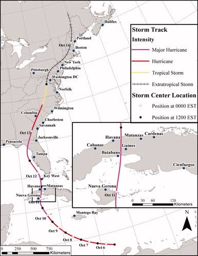
The Oct 1846 hurricane was exceptional as well. A 2021 study showed that if such a HU occurred today, costs would be over $100B for the E Coast. https://www.tandfonline.com/doi/full/10.1080/24694452.2020.1838257 Unfortunately. the paper is behind a paywall.
-
Yes, and POR (period of record) considered is paramount, so mentioning the paleoclimo record of 1000 years is key to historical discussion. I get the distinct impression from the mainstream, it like everything prior to 2000 didn't happen! It's all about here and now, and the past/history be damned! Oh, I know why that is and the media business model, but it misleading so many as to wx events these days. Facts are meaningless w/o context, so you can't treat wx events currently or recently in a vacuum! That's why studying history is so important. Why I said 2000 above as "that's when wx history 'started'?" I've see those little daily wx calendars where you rip off a page each day, and it became quickly obvious to me that most wx events were post-2000! Not that there were not sig wx events on the days post-2000, but why would they *not* list the Tri-State Tor on 3/18/1925 or the GLS HU on 9/8/1900?
-
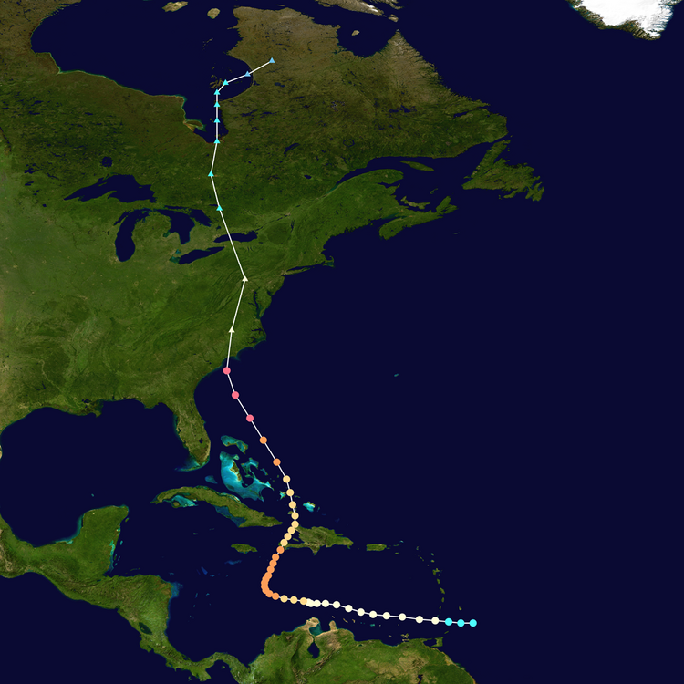
Hazel in Oct 1954 was a rare beast. First, it is strongest, farthest N HU landfall for so late in the season the CONUS on record (115 kt). Second, it likely the quickest ET transition for an intense landfall CONUS HU. HURDAT2 shows it ET only 2.5 hr after landfall! Third, its phase w/ a strong baroclinic trough was about as ideal as you could get, similar to Fiona in Sep 2022 I bet. It still had sustained winds of 70 kt when it was at 40N/77W, which is extraordinary. It was racing N at 42 kt once inland as well. A truly exceptional event, similar to Sandy, but for wind more potent. So is it any surprise such crazy winds occurred so far N? Not only NYC recorded its record gust of 98 kt, but also DC as well (85 kt). It's why I say events like Sandy are not unprecedented or really or not as uncommon as portrayed. Hazel, the 1938 New England HU, and Agnes in 1972, were much like this, getting picked up strongly and eventually phasing in w/ an potent baroclinic trough that would have resulted in a sig storm even w/o the HU present. And they each ended up setting the big records differently. Hazel and 1938 was about wind, Agnes was about rain/flooding, and Sandy was about storm surge.
-
2026 Atlantic Hurricane Season
vortex95 replied to Stormchaserchuck1's topic in Tropical Headquarters
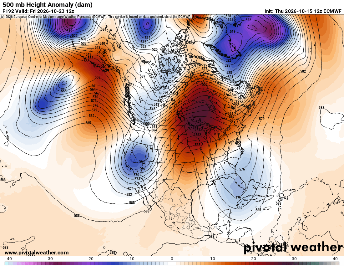
I am just a little surprised at the degree of blocking and amplitude given the very strong El Nino. A strong STJ from the El Nino usually prevents patterns like this (moves things along) and we already saw the STJ quite apparent that impacted Isaias. That was unusually strong STJ trough for the Gulf Coast for early Oct. 12z ECMWF looks like classic omega! What is this, May? I will say this. given the non0-linear nature of the atmosphere and its associated oscillations, something coming in being as the strongest on record (El Nino), unexpected things can and do happen that do not fit "what we thought should happen." I mentioned this before, it was assumed before that in very strong El Nino, Cali gets soaked and the Pac NW is dry. Well the 2015-16 event, the exact opppsite occurred!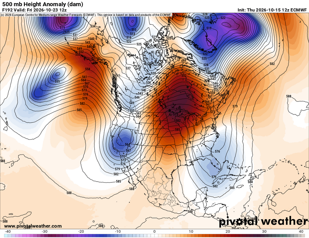
-
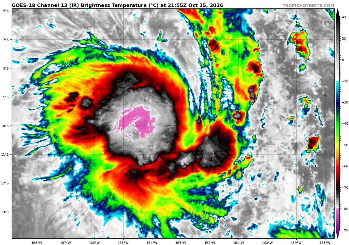
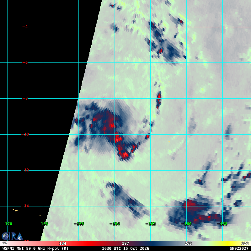
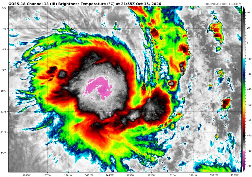
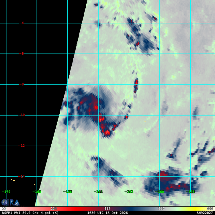
SPAC starting already and well E of the Dateline. TCs well E of the Dateline are common in very strong El Nino years. 92P is easily a TS now from Dvorak classification. That kind of cold nascent CDO over a well-defined LLCC? The microwave from 1630z clearly show good banding and a small core. But not declared by JTWC yet, and only a TD from Fiji. They wait too long in the part of the world for developing TCs I have observed over a long time. Just one example of how it not easy to compare stats basin to basin due to different standards and practices.
-
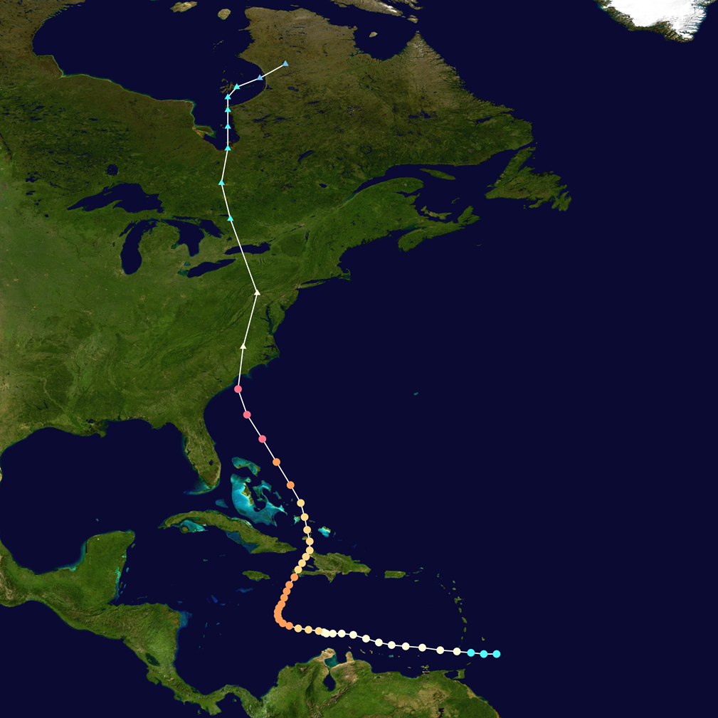
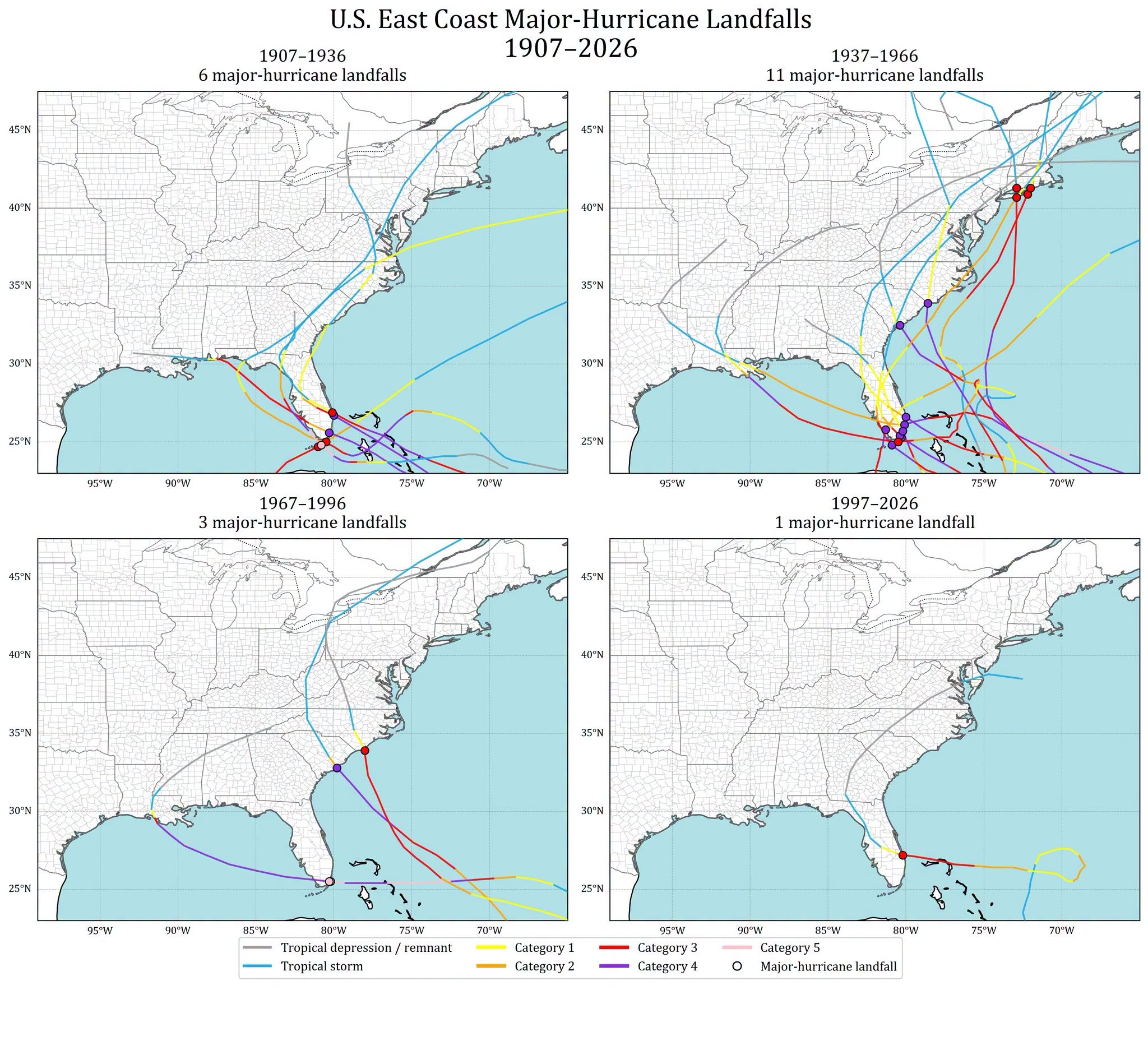
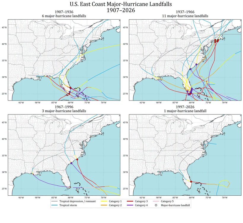
The AMO cycles 25-45 years based on the Atlantic HU activity going back to the late 19th century. We are in year 32 of the active phase, so it could end any year now. Regarding E Coast landfalls, it depends on how you look at it. If you go by major HU E Coast landfalls, events are *way* down in the last 60 years compared to the previous 60 years. See graphic attached. There has not been a major HU landfall GA to ME since Fran in 1996. And for the entire E Coast, not since Jeanne in 2004. And I would argue this is the most important stat when considering changes/trends over time b/c major HUs do a disproportional amount of impact/damage. And I know one can say, "well, what about Gulf landfalls?" That is valid statement, as those show a different trend. However, what I find far too often is that facts/data are cherry-picked, and the omission of key facts/data is really no different that lying. The point is that one needs to include all valid/relevant data when making claims for changes/trends and look over long periods of time, not hyper-focus in short-term snapshots and run w/ that as if that how it is going to be proves one point. Unfortunately, the MSM and too many on social media largely ignore this and run w/ whatever gets eyeballs/clicks/likes best, and that is gloom and doom and the end is nigh. There is a saying here, "never let the facts get in the way of a good story." For any HU landfall for a E Coast location, New England has not have one since 1991, its longest or 2nd longest gap period on record (depending on landfall definition). So it is not just anecdotal that things are not as frequent of bad for the E Coast. Actual hard data support it.
-
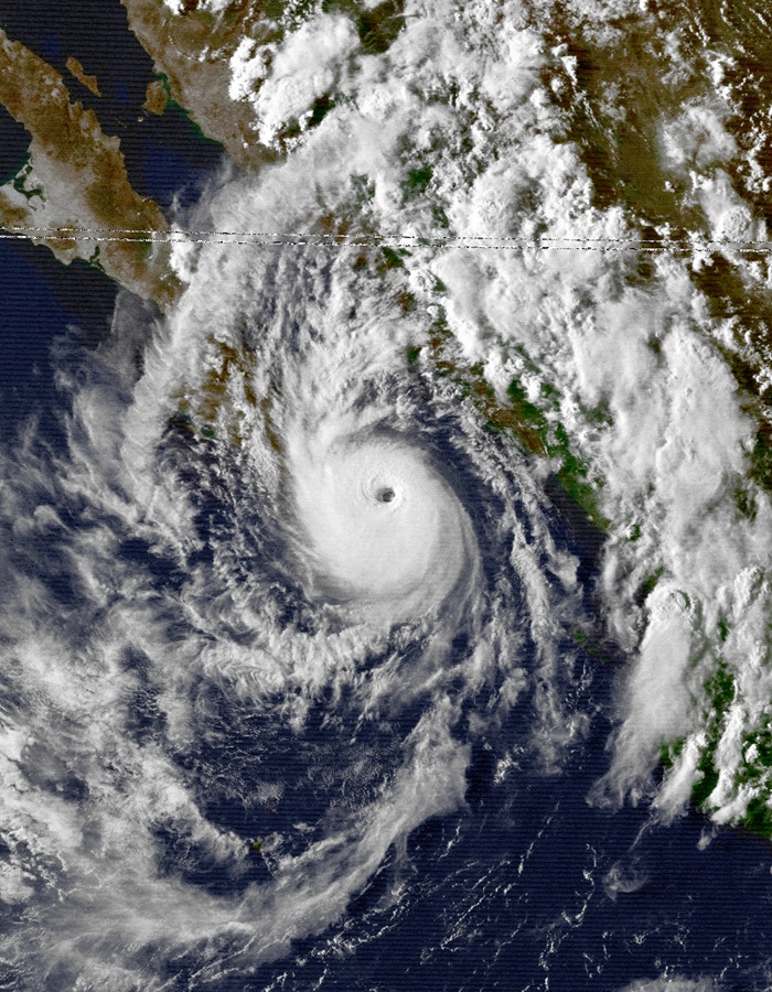
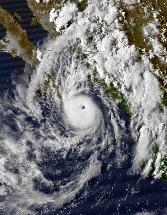
It had a 34 kt radii the other day as a HU down to 30 nm. That's on par for the smallest 34 kt radii HUs in the Atlantic. 2004-2024 avg R34 35 nm or less Jeanne 28 nm 9/16/04 Humberto 26 nm 9/13/07 Michael 35 nm 9/5/12 Lee 30 nm 9/24/17 Beryl 25 nm 7/6/18 Isaac 30 nm 9/10/18 Oscar 35 nm 10/19/24 Only hurricane that comes to mind nearly as small in the EPAC is Kiko from Aug 1989 with a ~45 nm R34, and it was in the same area as Simon (VIS image attached). On Oct 10 at 15z, Simon's R34 was as large as 110 nm in one quadrant. The storm has gained about 6 degrees of latitude since it genesis. So how does a long-lived, intense TC that gained reasonable latitude shrink so much? I read that it proximity to the Mexico coast and the downslope from high elevation just inland was a factor, but many TCs parallel close to the Pacific Mexico coast, and we do not see this kind of reduction in size. Why was Simon different here? Normally, TCs grow in size w/ time from ERCs and latitude gain.
-
@ineedsnowand @CoastalWx immediately rushed to see what *exactly* happened in SNE in 2000-01 winter!
-
When we get the ultimate 'cane here, this will be the most popular video by far! @CoastalWx be like, "how can this happen?!"
-
Do you mean "largest TC tornado outbreak in the states history? B/c you have non-TC events like this. https://www.spc.noaa.gov/climo/reports/110416_rpts.html I count 14 NC tors from the 2020 Isaias.