vortex95
-
Posts
1,488 -
Joined
Content Type
Profiles
Blogs
Forums
American Weather
Media Demo
Store
Gallery
Everything posted by vortex95
-
It does not surprise me one bit! Never underestimate the drive to get more ratings, no matter how ridiculous or stupid it sounds! And it can be taken even further here, and it proves what I have said so many times in recent years. The ordinary is now turned into extraordinary! So this is a fcst for New Orleans. You know what the normal high temp is for June 27 (date of this article)? 91! And dew points are in the 70s almost all the time in summer, so afternoon heat indices are in the low 100s, and 107 like mentioned here happens a significant part of the time every summer. So how is this "dangerous?" This is normal climate for this area, and ppl are *used* to it. This idea that just b/c temps 90+ and the heat index 100+ somehow that means this summarily bad for humans is bunk. Ppl adapt well to their local climate no problem, have so for 1000s of years. "By Monday, temperatures will surge even higher as a strong heat bubble aloft moves northward over the Tennessee and Ohio River Valleys, keeping the New Orleans area well above normal. Combined with higher humidity, Tuesday is shaping up to be a hot day." 2 F higher is a "surge?" And 3 deg above avg for a high temps is not "well above normal." Oh, the drama! I get sometimes, "well, that's just the way it is." I am not contesting that. Society changes/evolves. What I am contesting is the relentless fear-mongering and making mountains out of molehills. Crying wolf all the time is a bad thing, no? Putting ppl in a constant state of alert is unhealthy both physically and psychologically.
-
The tactic "scare w/ large numbers" is a biggie. How about "340 million people under high UV risk today!" Sounds ridiculous, but the trend to demonize *everything* no matter what is strong, so just you wait! And one could say, "well, UV is ionizing radiation and is a real risk!" and they would not be wrong. Very sleazy way to justify hype. Since ubiquitous well-known risk exists every day routinely, there is no practical value bringing it up most of the time other than for ratings and hype. We learn about normal risk from a young age. Risk is everywhere, and constantly bringing attention to it is counterproductive. Yes, alert the population as needed, and *not* for your own profit/business!
-
Yet so many ppl do not think twice taking the dog out for a walk when lightning is hitting not that far away and the thunder is very loud. As long as it is not raining, who cares?
-
Wow, this is a good one. Thanks for passing along. It may be a doctored image, but *nothing* would surprise me these days. And something like is done here? This would fall under a classic tactic from the book "How to Lie with Statistics" (Duff, 1954 - you can find it free to read on-line). It goes like this: On a graph, play w/ the y-axis. You can make things look as significant or insignificant as much as you want visually. Ppl are drawn to a flashy graphic first, and the labeling second (if at all). And this has been shown to work or influence in any venue/setting to get a particular message across. Over time, no matter how cheesy or insignificant it may be, for a hype angle or to simply grab attention more, nothing is off the table! I get the business model and why it is done (competition is intense/shorter attention spans), but it has become ridiculous. Micromanaging/slicing and dicing to the extreme, and I am not just making deductions/suppositions from what I see presented. I know a number of of OCMs, and some have told me this is how it really is. Many OCMs do not want to do such things b/c they want to keep it real and based, but they are told to do this by the news directors or consultants, and have no choice. And the book I mentioned above, you see that the saying, "there are lies, damn lies, and STATISTICS!" is not just some casual idiom!
-
Hoisting the Sultan Signal: Heavy Rain Event July 5-7
vortex95 replied to WxWatcher007's topic in New England
That 29" at CAR was its biggest 24 hr snowstorm by far up to that time. Attached is a classic weenie snowfall map from Storm Data for this storm!
-
What is said above I agree 100%. Rating it? It looks about "average" for a svr wx event we typically see this time of year. Just b/c it is "average," certainty does not mean it won't be good, and some areas will get crushed, esp. w/ rain as PWATs are over 2" and K-indices 34+. Storms should largely move orderly W-E 20-25 mph. Short bow segments and clusters w/ marginal/brief supercell structures are likely. Tornado threat is low since winds are rather light 850 and below. However 0-3 km CAPE is excellent so an isolated QLCS spin-up is possible. On the large-scale, the flow aloft today was weakly anticyclonic, but that switches to more solid cyclonic Thu. Just noting that b/c even in absence of a distinct s/w trof, anticyclonic vs. cyclonic flow makes a sig difference for convective initiation and maintenance. No capping issues Thu due to cyclonic flow! HRRR gives the Delmarva the most QPF. This does not surprise me. I have noticed anecdotally, storms often do very well here. Probably due to more boundaries and slightly higher DPs since you have both the Bay breezes and sea breezes interacting here. Look like general showers/tstms around Fri-Sat and maybe Sun, then a break Mon-Tue as we have a stable wedge of high pressure in the region (looks like cold air damning in the summer - see GFS valid 12z Tue below) Then more interesting after that w/ NW flow svr wx events possible.
- 1,481 replies
-
- 1
-

-
- severe
- thunderstorms
- (and 7 more)
-
Good info! Thanks. This kind of discussion is great b/c it puts forth different views/angles that we all can take in, and then make adjustments and see things better. It is all too easy for one to isolate themselves in their own mindset/attitude, and forget there is always more too it or another way of looking at it! Perhaps "cowering" was not the best term choice, at least not as to what actually happens when sig wx occurs, However, the message being put forth, from the individual to big media, is on the level that "cowering" does fit IMHO. This is biggest tissue I have -- how wx is handled/presented by so many in recent decades. That has devolved significantly, and has real physical and physiological impacts. I agree that more ppl than not get it and do to succumb or fall prey to excessive hype, but unfortunately the vocal minority that do get *most* of the attention, and even one person crying foul in some cases, ends up going viral or officials/authorities/politicians overreacting, and it ends up being a much bigger deal that it actually should be, and this in turn affects mindsets, zeitgeist, and policy. And also, you get those in charge using wx events for ulterior and questionable motives at times. And due to excessive hype, it promotes distrust and apathy in the public, and that can and does have consequences that are non-trivial. Social media is biased w/ hype and over the top b/c it get clicks/likes and drives the algorithms, so individuals not only benefit, but also the platforms do, and you get this feedback loop, and the platform quality goes down. I have no problem w/ hype when it is warranted, meaning when something truly big is fcst that will have impacts way above the norm and/or is quite rare, like a Sandy or the Oct 2011 snowstorm, going full throttle is a good thing. But crying wolf for virtually *every* wx event is ridiculous and counterproductive. What WxWiz said about local hype in CT for the most recent rain event is a good example. Yes, in a vacuum, 4-8" of rain fcst is a concern, but as discussed, there are other factors to consider. esp. when talking about *impact* to society. The MSM and hype-masters often conflate an event intensity and impact. The two are not always direct correlated! And we have the tech, skill, and knowledge now to quite easily quantify and scale wx events very good, but not all for various reasons are taking advantage of it! For instance, you will still here some ppl think/say (anywhere - the public to officials/authorities) -- "well, you never know w/ the wx!" That is a largely an out-of-date and weasel excuse these days.
-
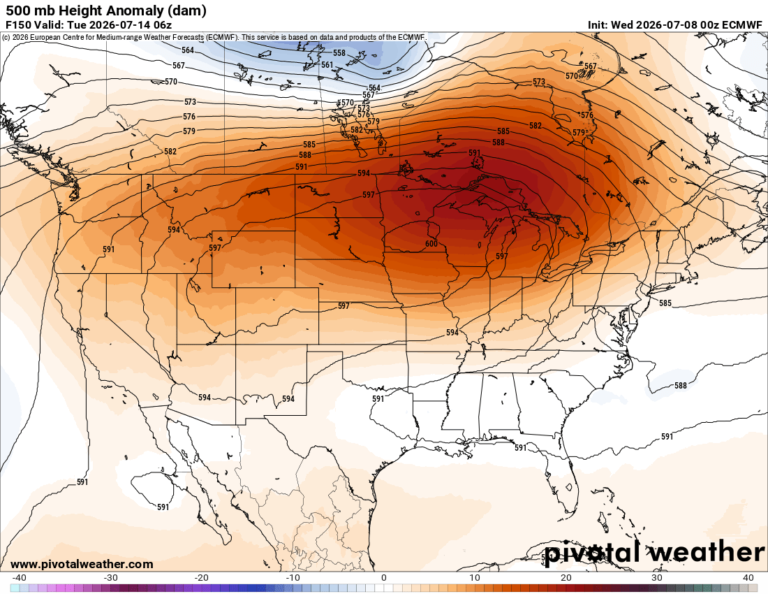
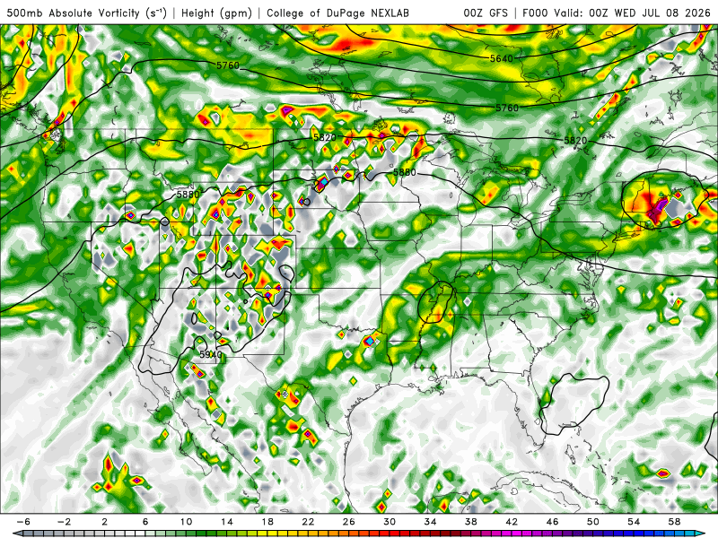
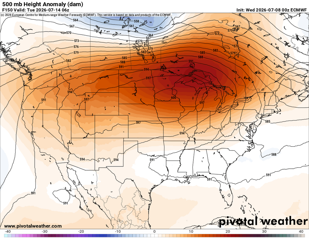
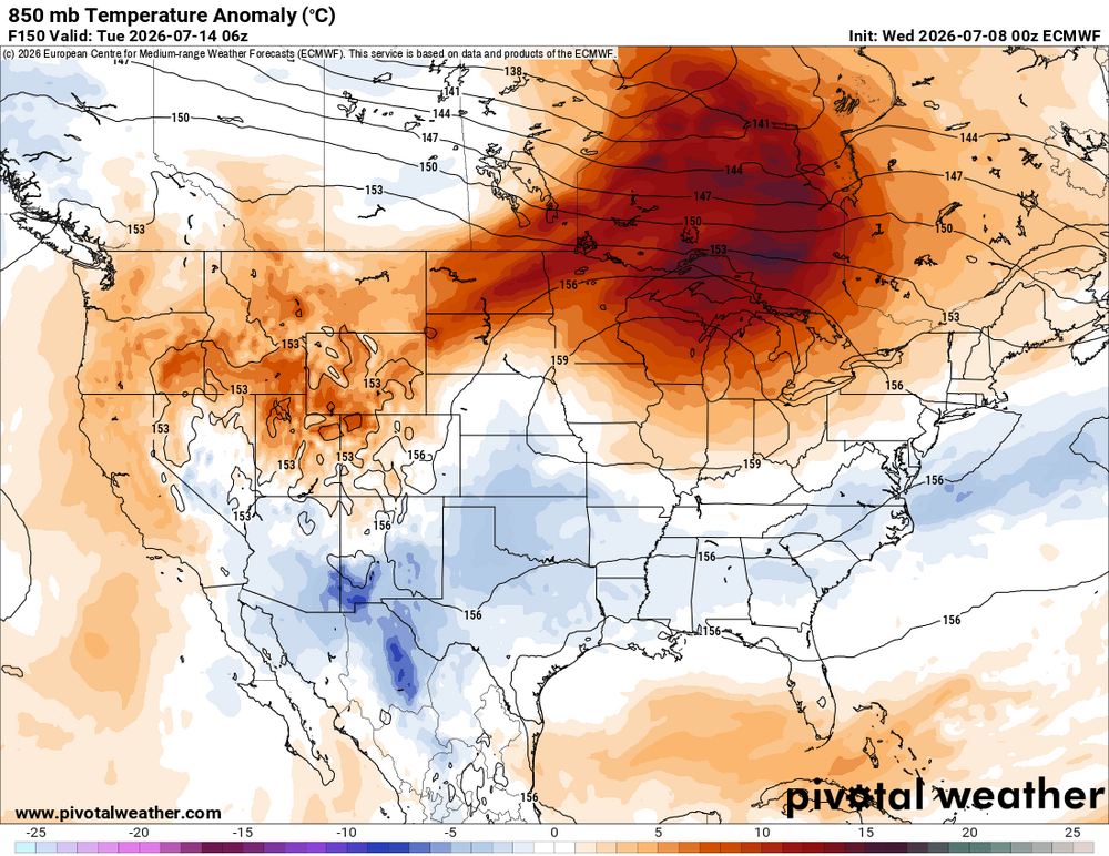
I wanted to follow up on a post I did last night. Some details here that may not be so apparent to all, and this evolving pattern provides a good example how it's not "one-size-fits-all" for a given pattern and sensible wx. The details count and help quantify a fcst better. In this case, it will not be the same as the pattern we had last week w/ the snow in the Northern Rockies and big heat in the East, despite a strong 500 ridge fcst. I attached a GIF loop of the GFS 500H/V for the next 10 days. You can see the ridge axis/center that forms so far N, you actually get tropical-type easterlies across the srn half of the CONUS and westward moving disturbances. Not tropical waves per se, just weak 500 lows. The first shows up over KS/MO/OK at 96 hr and then moves W under the ridge to the Central Rockies where it merges w/ a vort center that is stuck within the ridge, and then it all ends up moving N and then E around the top of the ridge. And then look at about 156 hr on the SC/GA coast, a small 500 low develops moves W and eventually ends up over srn NM. In this case, despite the 600 dm ridge, this is not classic big heat pattern for the CONUS. It's tropical and unstable w/ easterlies across the srn 1/2 of the CONUS and in the Rockies, despite ridging aloft, weak disturbances are embedded w/ a lot of mid-level RH present. So this means considerable amounts of diurnal RW/TRW, which keeps temps from getting really hot, and is why the 850 temps avg slightly below normal across the srn 1/2 of the CONUS (150 hr ECM 850 anomalies attached) Also, and I failed to mention this yesterday, yes, it is large and strong ridge, but also a *broad* W to E ridge and wavelengths are not sharp, unlike what happened last week. Not all ridges of high pressure are alike, but some act like that. Seriously, one well-known TV met actually has said, "two heat domes will merge and become one large one next week." As if that means anything as to more extreme temps? That's not how it works for high pressure. This person is trying to force the notion that when two low pressure merge (like a ET low and TC), it works the same for high pressure, and thus an end product more intense. Vapid and linear thinking, preying on public ignorance. Ppl just making things up now for hype! The "two heat domes" that will "merge" mentioned above. If you look at the 500 over the CONUS now, they are typical subtropical 500 highs you would find in mid-summer, one over the Desert SW and another one near the Bahamas. So every ridge of high pressure that has climo hot wx is a heat dome now pushed as unusual? And these two subtropical highs, look at the 500 evolution, there is no sign of any "merging" here. I know I have said stuff along these lines before, but I wanted to share another example of how statements on wx just keep devolving more into slop, and at the same time, point out for the ppl on the forum here some of the finer points of a ridge pattern in this case that from a bird's eye view, it many looks the same, but upon closer look, there are important differences that make for different sensible wx.
-
EMLs are tricky. They are most prevalent and strongest when the atmosphere is very warm ("warm" being relative to the time of year). This mean things are often capped. So despite tons of CAPE and shear, no storms will develop. But if you storms to fire, then you have a primed environment for svr storms. Weak EMLs are often present, w/ mid-level lapse rates 6.5-7.0 C/km, in many tstm days here. However, you want to see at least 7.0 C/km solid for noticeable results or differences. And just a 0.5 C/km difference is huge b/c the range is small. The dry adiabatic lapse rate is 9.8 C/km and the moist adiabatic lapse rate varies depending on temp and moisture, but in the warm season, anything under 6.0 C/km is not good (it does not mean you can't get big storms though). Generally, look for greater than 7.0 C/km at mid-levels in a fairy thick layer on an observed or fcst model sounding. On the models for mid-level lapse rates, they use 700-500 mb. However, that can be misleading. You may have at 150 mb thick EML between those two levels, or say from 750-550 mb, and this qualifies. EMLs do a couple of things that lead to better storms. 1) EMLs promote elevated CAPE, and this CAPE exists independent of diurnal effects, so loss of daytime heating is not as much a factor. And during the day before the convective temp is reached, you already have CAPE aloft just waiting to be tapped, and links w/ building sfc-based CAPE. In the end, you get considerably stronger updrafts in CBs. 2) Where an EML exists is often the best hail growth zone in a CB, so hail at the sfc and/or larger hail is more likely (steep lapse rates and higher mid-level CAPE mean more vigorous updrafts at mid-levels). 3) And along the same lines as above, the EML can be in or close to the mixed phase layer of the CB where charge separation occurs the most, so that means more LTG, esp. in-cloud LTG. Solid EMLs on the East Coast are not common, at least those that occur in sync w/ proper low-level moisture and dynamics/forcing to result in significant svr wx events. Two of the biggest ideal EML events are June 23, 1944 Mid-Atlantic tornado outbreak and the June 8-9, 1953 Great Lakes-New England tornado outbreaks. Another one was July 10, 1989, which is the record for most tornadoes in a single day in New England. That day I experienced first-hand, and that’s when I took note of the EML factor. IAD sounding 00z on the 11th had a distinct EML present. However S of NYC, not storms occurred b/c it was capped. So for the Mid-Atlantic and Northeast's biggest tornado events, typically a solid EML is present, but everything else has to line up almost perfectly for an actual high-end event. In general, having an EML present is a good thing if you want more intense tstms and more overnight storms. I really like what I see coming up for the CONUS 500 pattern. Big hot ridge to our W and we are in persistent WNW or NW flow aloft. This is how you advect a solid EML from the Plains to the East Coast, and WNW or NW flow historically had led some of the biggest svr wx outbreaks in the summer months for the Mid-Atlantic and Northeast.
- 1,481 replies
-
- 6
-

-
-
- severe
- thunderstorms
- (and 7 more)
-
Hoisting the Sultan Signal: Heavy Rain Event July 5-7
vortex95 replied to WxWatcher007's topic in New England
Sounds like damage control in link title --"not nearly the rainfall we need." Ok, who ever said it would be enough? The point is we got a solid widespread rain event. You have to start somewhere to come out of drought conditions. Geez, wx does not work in nice, neat, even increments and balances out 1-1 when talking short periods of time. A case of you can look at the glass half-full or empty (yes, the pun is there but not intentional!). -
Hoisting the Sultan Signal: Heavy Rain Event July 5-7
vortex95 replied to WxWatcher007's topic in New England
Sorry, I couldn't resist! -
Hoisting the Sultan Signal: Heavy Rain Event July 5-7
vortex95 replied to WxWatcher007's topic in New England
What happened to your warm front *absolutely* needed for the big R+ in a summer month? Nor'easter is still a nor'easter in July. Only difference is that they are weaker and smaller, but much higher PWATs tend to compensate to give solid QPF. The OER was neat to see today streaming in from the due E! -
Hoisting the Sultan Signal: Heavy Rain Event July 5-7
vortex95 replied to WxWatcher007's topic in New England
Even if it was 4-8" widespread, it still would not have been that bad overall b/c it was going to be spread out and most importantly, very dry antecedent conditions overall across SNE! So much of the MSM and hype masters have no clue, or do know, but ignore b/c deflates hype. They think "one-size-fits-all" and the one size is always means the worst. That's now how the wx works and we can do much better now due to improved modeling and understanding of the wx. There is no effort to quantify or scale wx events anyone -- again, it's always "the worst." So you see my overall critical position on how wx is treated in general is not w/o merit. This rain was very beneficial and we needed it, but that is good news and doesn't sell. -
Hoisting the Sultan Signal: Heavy Rain Event July 5-7
vortex95 replied to WxWatcher007's topic in New England
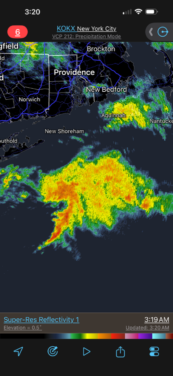
Yes, you could clearly see two level of pcpn on radar, low and high, moving in different directions and overlapping, which likely lead to the dense small drops (super "sheet" drizzle?). Almost like warm process rain but w/ more baroclinicity. -
Hoisting the Sultan Signal: Heavy Rain Event July 5-7
vortex95 replied to WxWatcher007's topic in New England
Nice li'l tight/coherent wrap up. Models showed this well. Don't always need a deep sfc coastal low for "fun 'n games!" -
Hoisting the Sultan Signal: Heavy Rain Event July 5-7
vortex95 replied to WxWatcher007's topic in New England
Can you imagine the consternation alone if this was a fcst snowstorm? 24 hr ago, DXR would have had 2 ft and PVD a foot, and a dusting at BOS. CoastalWx would be like, "HOW CAN THIS BE????!!!!" and basically ready to call it quits, and then the big backlash comes in and saves the day! Reminds a bit of the Bliz of 96 in ern MA. Got about 5" in Woburn w/ an initial burst in the evening, then MEH for the next 8 hr (2SM -SN and I got about 2"). Then the "backlash" came in and I got another 8". So a great storm total (for 1996), but it was piecemeal. Not a smooth event! Also, one of the storms in the Jan-Feb 2015 blitz. SNE got a burst of S+ in the evening, and then it completely stopped, and BKN conditions w/ stars visible along the S Coast. This mesoscale thing w/ a arc of snow moved into srn NH, then drifted back S after midnight, and then incredible development w/ super TS++ predawn into later that morning. Rumor has it CoastalWx passed out a few times due to his ecstasy! Again, not a smooth event, but it all worked out in the end! -
First warm blob, now cold blob, next it will be NEUTRAL blob, and they will find an issue/problem w/ it!
-
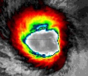
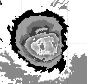
Dvorak CI is back up to 7.0 which is 140 kt, after being down 5.5 last night. 7.0 would normally assign 140 kt, but since the eye is so large and a bit ragged, JTWC went w/ 130 kt, which is reasonable. The eye pressure may be as low now as it was when Bavi peaked at 155 kt, however, tightness of the inner core and eye size are paramount. After a couple of ERCs, the overall size of the storm expands and inner core tightness is less (overall power of the storm is basically the same, just spread out more). Also, a slow gain in latitude is increasing Coriolis, and this results in a gradual decrease in tangential winds speeds over time. It's one reason why you rarely see pinhole eyes N of 30N. Eye size is challenge, It depends on if you use IR or VIS, and within IR, what color table you use! Attached is Bavi's eye currently using EIR, BDIR (Dvorak), and VIS. I get 55 nm, 40 nm, and 30 nm for a diameter, respectively! Notice the difference between EIR and BDIR, The BDIR shows the stadium bowl eye structure better than the EIR.
-
For all intents and purposes, this is the truth. Concerning hot wx, it wasn't so long ago when it was 90+ in New England, they would just say, "a great beach day or BBQ evening!" Now, "stay indoors and cower in fear b/c it is so dangerous outside!" You see how inane that is from just a daily living POV. Yes, you take precautions, but don't let it ruin your day/plans -- or LIFE! Being put in a constant state of fear/alert, that's not "living," that's "existing!" Don't get me wrong, I don't like harping about all this and want to avoid the negative, but at the same time, I feel for the public and up and coming mets and wx enthusiasts that either have no context/perspective or just can't figure out what is what, or who is keeping it real, and who is just off the rails hype, and everyone/everything in between! I know how I would feel if I was a newb and up and coming these days. For those of us that have been around for awhile, we've all been there! Most of the public just wants the basic what, when, and where for wx, at least in real time and for practical daily use. The how and why are secondary or irrelevant! And ppl I speak to that are not mets, most really appreciate the based and straightforward fcst and wx reasoning. And they like to learn about why this or why that b/c they all have seen many forms of of wx, and when the big stuff happens and makes a huge impression on them, they wonder, "what the heck caused that!?" And they all have big storm memories like weenies, it is just more latent/passive, but when you bring an event up, the interest surfaces quickly! Now for mets and wx enthusiasts, we of course want to know the how and why as well, and that's a good thing. But the challenge is for many is just plain information overload and sorting it all out. There is lot of good, solid, and accurate info out there, but also a lot of nonsense and crap. It's funny back in the day (pre-Internet), wx info, esp. for a weenie, was not easy to come by. You had the local news and your wx radio, and then TWC by 1982. And then *any* wx book/magazine you could find at the bookstore or the library (there were not that many, at least compared to the 90s and later)! And the occasional TV special on wx (NOVA on PBS was really good for this). That was about it! Now, it's the other extreme. TMI and not enough time. One can actually get stressed out trying to follow and keep up just for all the models alone we have now (CoastalWx?, WxWiz? LOL)! And then you have social media and mobile devices. Sometimes now, I actually *welcome* a quiet period for wx so I can catch up w/ other things!
-
If we can get a solid EML (elevated mixed layer) to advect in from the Plains/Midwest, things could be really potent. Big hot ridges to our W w/ WNW or NW flow aloft here is about the only way this can be done. One thing w/ EMLs is that overnight tstms are much more common and more intense. Diurnal heating means little w/ you have lots of elevated CAPE. It's why there are so many overnight intense MCSs in the Plains/Midwest, and the LTG displays are incredible. Not necessarily more CC or CG bolts, but the IC flickering is often amazing, esp. in the mid and upper parts of the CBs.
-
Hoisting the Sultan Signal: Heavy Rain Event July 5-7
vortex95 replied to WxWatcher007's topic in New England
Or getting "only" 18" of "white rain" in Weymouth instead of the 24" fcst?! -
Hoisting the Sultan Signal: Heavy Rain Event July 5-7
vortex95 replied to WxWatcher007's topic in New England
RAOBs (wx balloons) missing is a weak argument these days. Ppl need to get out of the legacy mindsets and get w/ the times. RAOBs are not as super critical as they once where. You have so many other sounding-type data available now, both in situ and remote, like ACARS data from aircraft and NUCAPS soundings several times a day over the CONUS alone from the VIIRS polar orbiters. And we have GOES imagery that updates for the CONUS every 5 min and 4 mesoscale sectors that update every min. Also, a full disk sector every 10 min. Prior to 2016, it was only every 15 min for the CONUS and only once every 3 hr for a full disk. The sampling of the atmosphere over the CONUS and the GOES footprint is way higher now than 10 years ago, both in spatial and temporal restitution! When the next generation GOES-E and W satellites went into operation in 2016 and 2017, respectively, the number of GOES channels went from 5 to 16. It all goes well beyond the basic IR, VIS, and WV channels now to get a significantly better picture of the atmosphere. 85% of all model data globally comes from various types of polar orbiter satellites, and they measure/sample a lot more than just clouds. And those "missing" RAOBs site you see at 12z, almost all of them are taken at 18z instead. Yes, not ideal, but we do run 18z models now, so they are not going to "waste." Who's to say 18z model runs for the CONUS are not somewhat better now at the expense of the 12z? It may be a wash or so little difference, it does not matter. I am not saying RAOBs are not still valuable, they are, but some ppl can't resist drama, stirring the pot, and complaining for clicks/like/attention, among other things, these days and sometimes are disingenuous, as in knowing what I said above about other sources than RAOBs, but leaving it out for "engagement/rage bait." -
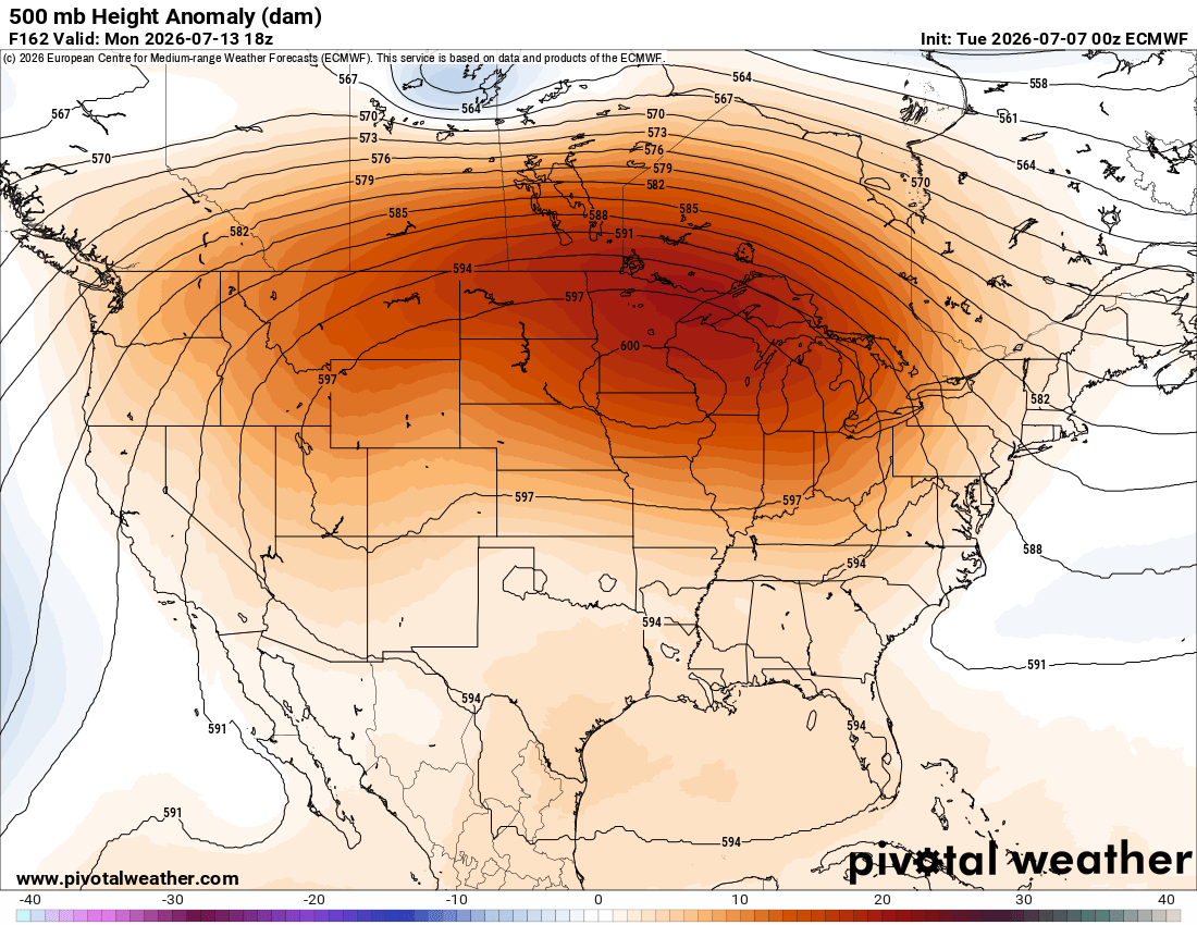
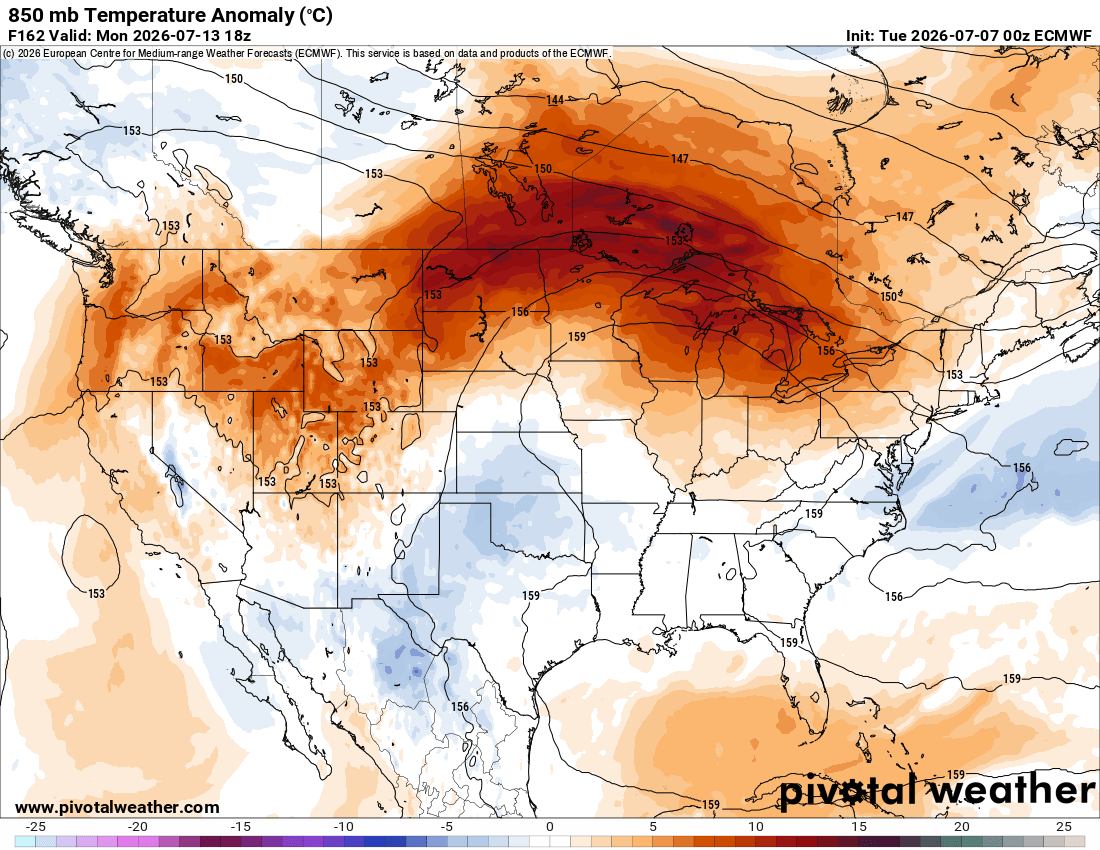
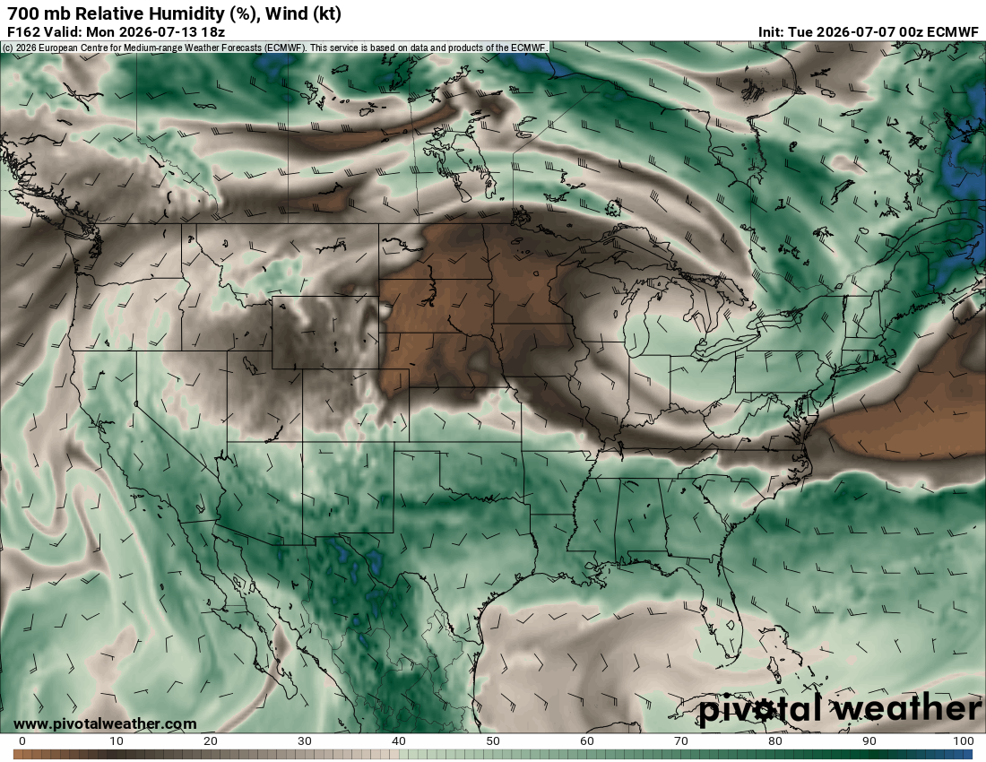
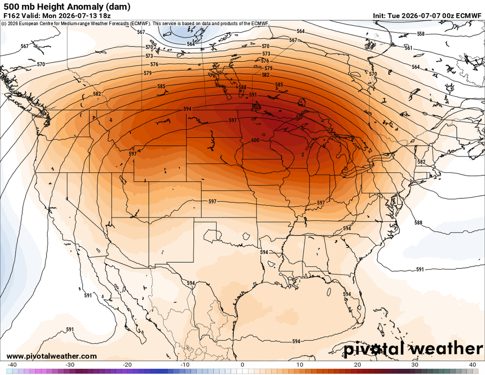
For all the hype talk about the big ridging and heat for the CONUS coming up central and west, looking at the anomalies fcst, esp. at 850, it isn't nearly as impressive as you would think for a large 600 dm high center spread out over the country. Take a look at the 00z ECMWF at 162 hr 500/850 when the 600 dm center is most prominent (attached). Big heat is limited to the northern tier, and just MEH central and south. What is happening in this case, the ridge center and axis is so far N, you actually get very weak troughing and a rather moist tropical-type air mass over much of the southern half of the country (see 700 RH fcst attached). Pattern for us looks quite good for svr. "Over the top" ridge EML should be fed nicely into the NEUS.


-
Hoisting the Sultan Signal: Heavy Rain Event July 5-7
vortex95 replied to WxWatcher007's topic in New England
Yah but the 00z ECMWF shows Weymouth still getting 4"!!! LOL. -
Hoisting the Sultan Signal: Heavy Rain Event July 5-7
vortex95 replied to WxWatcher007's topic in New England