

vortex95
-
Posts
1,493 -
Joined
Content Type
Profiles
Blogs
Forums
American Weather
Media Demo
Store
Gallery
Everything posted by vortex95
-
Looks decent for CT. Latest HRRR suggests a small bowing segment 7-9pm.
-
Scott rain PT.
-
Only Ineedsnow would say MEH to a 140 kt STY! It's the CoastalWx equivalent of saying MEH to 6/1/11.
-
Take a look at this short paper from 2004. Odds are it has been exceeded, and since 2004? Several candidates (Haiyan in Nov 2013 almost certainly). strongerTC.pdf
-
If we only have recon in these monsters. I will tell you given what recons measured from the 1940s to 1987 in the WPAC, if it was done today w/ the much more advanced tech such as GPS dropsondes and the SFMR, you want to talk records and extreme that would put all to shame what we have seen in recons in the ATLC? The few research mission recons we have had over the years in the WPAC have shown incredible stuff. Satellite estimates can only do so much. Dvorak estimates work best for TCs between 60 and 105 kt. This means two things - 1) many TDs are actually weak TSs, and 2) most very intense TCs are underestimated. The inner core of these things are strange beasts, acting more mesoscale than anything when you get to Cat 5 levels. EPAC Patricia in 2015 would have been capped at 160 kt from satellite estimate only, but recon actually found 185 kt winds. As a result of the above, TC intensities and annual ACE globally are underestimated, and the further you go back, esp. prior to the satellite era, the more off it is. And really w/ recon, we only started to see things in proper detail w/ the advent of the GPS dropsonde in the late 1990s and the SFMR in 2004. So you can't really use the database we have over the long-term for true TC trends.
-
Not sure if it will intensify much after passing the Marianas. It already had its first absolute peak on Fri, and now has leveled off at 140 kt. The eye is currently 30 nm in diameter which is quite large for such a low latitude and so early that far E in this tropical basin. Just saying that if you want a weenie super-duper intense TC, you want to see a pinhole eye, and Bavi never had that, and once the eye gets large, it does not go back the other way. Since the Bavi will slowly gain latitude and undergo ERCs, the eye should only increase in size. Might become an annular TC in fact (the "truck tire" look!). Annular TCs can still be intense (Isabel in Sep 2003 was 140 kt and a classic annular TC), but they tend to stay steady-sate for a long period of time once getting that structure. Ineedsnow will have live Guam radar up 100% of the time for the next several days?
-
One thing that is apparent, when you look at deep at historical data and wx events of the past, you find many that match or exceed anything today or in recent years. But history be damned in favor of the narrative. A friend of mine who gets the small wx calendars that you remove a page a day, he notes obvious bias as to historical wx events. He has told me it is like nothing ever happened/existed before 2000. All it talks about is extremes in recent years. So when I say "narrative," I am not pulling things out of thin air. You can see clear bias and skewed facts all over the place w/ disingenuous motives. All I am saying is that *all* data/info be reported on or put forth, esp. in the sciences, since it is objective and based on fact. Then individuals can at least make educated and reasonable points/views/opinions.
-
So BDL unperformed overall. GFS MOS had 103 Thu/Fri 18z 7/1 and 00z 7/2 runs and still just after was showing 101/102. Yet "only" 100 and 98 the 2 days. Wasn't due to convection or clouds. Any long-term MOS bias for BDL? I think the only reason why BOS hit 100 Fri was due to NW subsidence and the DP dropping to 57. What the MSM and others don't tell you or report is that once the dew point drops to 57 or lower, that heat index is actually *lower* than the air temp. BOS 100/57 at 3pm gave a heat index of 99.
-
Looking at the 04/00z NAM 700 analysis, a large area of +12 C exists over the region. 00z IAD sounding had +12.2 C at 700. +12 C at 700 typically caps things solid this time of year, at least locations near sea level. Today it cools ever so slightly at 700, and at 500 for that matter, and the ridging aloft weakens a bit. so we get more flow aloft, esp. at 700. Sfc T/Td basically the same as Fri so things should light up very well later the in aftn! CAPE 3000-4000 and decent mid-level lapse rates, so wet microbursts common. There is no 0-3 km CAPE, so tor threat is nil (LFC to high). Cloud bases should be fairly high so good photo ops. Winds 850 and below very light so storm motion may be slow and more mesoscale impacts to motion (back-building). Should see some big rains in some areas as PWATs juice up nicely right over the region during the day. Sun-Mon looks essentially the same w/ even more impressive PWATs. We do need the rain badly!
-
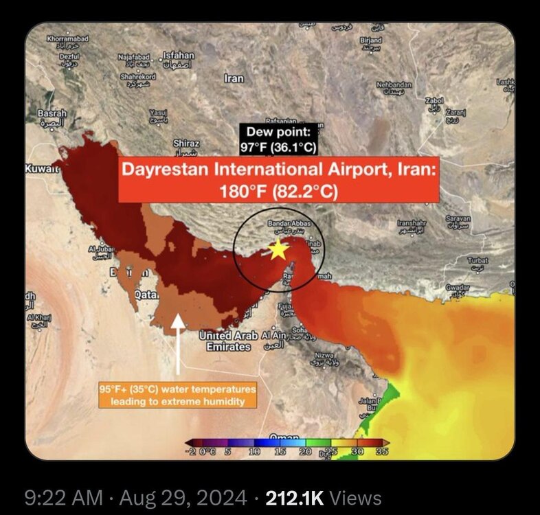
Thanks for the overview summary. Dew points often have even bigger issues than temps are ASOS/AWOS sites. I years ago looking at the OK mesonet (first installed in the mid 90s). Mesonet sites are typically sited properly and actually geared for climate data (ASOS/AWOS are geared more toward aviation). So many days when it was hot and high dew points, the ASOS/AWOS would almost universally had higher dew points than the mesonet. Well, they both can't be right! I'd take mesonet data over ASOS/AWOS the vast majority of the time. I recall about 10 years ago during a heatwave, JFK's ASOS DP got wacky and shot to 84 one day. Not sure what happened there. Also, there are so many types of wx stations our there (govt and private), all for different uses. Some are sited to monitor the local environment, like a marsh or a swamp. So what do you think the dew point will do when the equipment is next to or in a marsh/swamp? It's similar to all the marine sites out there. The anemometers are not all at the standard 10m elevation, so you have to account for this when talking records and the like. AWOS sites on oil platform heliports in the Gulf are often 100 ft or more ASL. Oh, and how about the AWOS at the smaller airports in the Corn Belt? IA has it a lot where at a certain times in the summer, the DPs get into the 80s. That is a local effect since corn has high evapotranspiration. However, at times this can impact convective initiation and intensity in the state and adjacent areas! A few papers has done studies on this. For the Persian Gulf, dew points in the 90s are a real thing in some areas. Qeshm Island (METAR code: OIKQ) in Iran is one such area. Every August in the mornings, they get ridiculous DPs in the 90s w/ heat indices as high as 180! I've checked the METARs and they are legit, given the location and how diurnally the dew point drops in the aftn as the BL mixed out. And the island's population is 149k. Quite impressive that humans can live in such an environment w/ little issues!
-
Nothing wrong or invalid in saying that. Mainstream narratives vary all the time, what is "in" and "out" changes, including in the sciences. Narratives for science issues are often dictated by non-science-based factors, no? Recency bias is a big one -- what is occurring now or in the recent past, is how it is and will be going forward (and the negative bias is huge). The more one looks at logical fallacies and cognitive biases, and how they influence us all and are used manipulate the population, one see things for what they really are. Also, science evolves. What is said or known now is going to change over time at various levels. There is societal arrogance that exists that we know best in the here and now and everything is figured out b/c things have come so far. That's not what history has shown. There is still a lot we do not know.
-
Thanks. I figured that. Heat index as a mainstream wx parameter is a relatively new (last 30 yr or so). They never talked about "feels like" temp much at all through the 1980s, local news or the NWS. We just heard, "it's not the heat, it the HUMIDITY!" Which is wrong factually. It's the "DEW POINT!" Period of record (POR) is paramount when talking wx records and historical context, something that often get ignored b/c it deflates the preferred narrative. Let me give an example. Last year, I saw a post one day something like 30 sites in TX set their all-time record high monthly temp (can't recall which month it was). In a vacuum, that was true. What they left out is since 2001, TX has added well over 100 AWOS METAR sites at airports across the state, and continues to add several each year. And many mesonet sites during this time as well, esp. in the TX PH and West TX. See the problem here? Period of record for many sites is very short, but they leave that detail out! Omission of facts is no different that lying IMHO.
-
Oh, I am not triggered at all. I know the main clowns on YouTube and other social media. Still, practice in calling them out w/ their methods can be a entertaining at times. Also, just sharing some critical thinking skills on "how to spot pseudoscience" and the like has value for ppl on the forum,
-
Again, it is about balance and handling skepticism in the proper way. It can get out of control very quickly, as you noted mentioning conspiracies. As for the media, scaring ppl into watching I find unethical and counterproductive in the end. That's what it is -- all about for profit. It wasn't always this way. And just b/c "that's the way it is" does not mean you just accept it and act like everything is ok and will be fine. So many being put into a semi-permanent state of fear or "flight or flee" mode is not healthy. I purposely over time has cut back (de-expose) myself to the MSM, b/c even if you are resilient, confident, and understand why things the way they are, the relentless negativity and hype is distracting and will test those even those w/ the strongest mettle. Being reminded constantly of all the problems/issues in the world, how is that good? And communicating this to others who may have trouble handling it all, that is a good thing b/c understanding it at least will help to assuage stress/anxiety.
-
Blame the wildfire smoke as to why BDL did not hit 103!
-
"Zygote?" LOL.
-
That's a good point, but the door swings both ways here. Repeating lies or gross exaggerations enough, people will start believing it. This results in the bandwagon fallacy (everyone is saying it, so it *must* be true!). Being skeptical is an invaluable tool. Not enough ppl IMHO use it, or more specifically, apply/handle it in the best (most balanced) way. So we often end up w/ the false dichotomy logical fallacy, believe everything or don't believe anything. Neither is good. How one presents data is paramount. Just posting random tidbits lacking detail or sources that more and more have AI-generated slop are rife these days and deserve to be called out. If one can recognize crap/nonsense/slop better, one will make better decisions and avoid being duped/scammed/brainwashed. There is one constant and fundamental issue that that makes the warming issue very enticing politically, socially, and economically. Touting the end of the world or civilization as we know it -- can you think of anything else more urgent and absolute than that to society? So riding that narrative sells easily and instills deep psychological fear in the population. In such a state, they can be molded/manipulated better. Claims the world is going to end due to AGW fits this category, and is why high skepticism and push back exists, b/c it is not so much about the science anymore, it is more about ideology/agenda/control. Having problems in general sense, real or imagined, unfortunately has been realized and abused in recent decades that there is enormous power and profit having such. Hence, where we are today. Nothing is scaled or put into proper context/perspective anymore. It's always "the worst ever" or "it was never like this before" or some variant.
-
Fuzzy anvils = bad sign for storm!
-
They largely do not/can not or ignore it. Why let something like that interfere w/ a particular narrative or ideology? And actually accounting for it is practically impossible. Sites move, land and water areas near and around sites change, and so does equipment type, and every location has its own unique changes over time. Given only about 2% of globally land is urbanized, and there is a distinct bias having GHCN stations near or in urban areas, well, it's not rocket science to see the problem here. Here's another thing that is not generally known or mentioned. Digital thermometers run warm. This is b/c they can record instantaneous temps well, unlike analog/glass thermometers of the past. Yes, ASOS is designed to take an avg of the temp for the last 5 min, but this is not standardized w/ all sensors/sites globally. And some agencies will take instantaneous temp spikes from artificial heat sources, and call that a max temp for a day or a record if applicable, even when it is obvious something is off. Or just use a site's 1-min temp data in calculations for mean temps. This falls along the lines of "how to lie w/ statistics." There are many, many way to crunch and manipulate data, let alone pick and chose data sources, that validate this statement.
-
The running joke back in the day was if you want hot, look at the bank thermometer! Pre-Internet all you had was the wx radio and the local news, so *any* other thing you could find that gave you wx was big!
-
How about this? The temp sensor at Logan in the late 1970s was moved from near the NWS building area to the center of the runways. This is why you see many 100 F+ readings up to July 21, 1977 and then not another 100 F reading until July 14, 1995. The UHI increase took 18 years to build enough to push temps to 100 again in the runway area that is surrounded by water on 3 sides.
-
Classic vague tease. "Get ready" For what? Makes one click! And the arrow points to northern Mexico? And it is totally unclear what the color shading is depicting, but as long as it is bright and flashy, who cares!
-
And the media mode skews perception big time. It makes things appear a lot worse than they actually are. The relentless nature of it wears on ppl psychologically, to the point ppl start believing it merely b/c it is repeated so many times. That's more in line of propaganda, rather that proof/fact. The most overused wx buzz word or phrase these days is "we're tracking!" Why wouldn't they be tracking? That's would be like saying, "we're forecasting! Superfluous and fluff language to make things sound more important than they actually are.
-
Earlier this decade for a significant period, EWR was clearly 2 F too warm. Every month, it would be +2 higher than all the other CLI sties in the OKX CWA. The issue go beyond just UHI and asphalt runways nearby. New constriction causes artificial heat issues as well. BWI has this issue, but only when the wind blows a certain direction. This is why one can't smooth out or "THREADEX" warm biases over time b/c each CLI location has different issues over time. Probably the worst sited CLI site, at least at an airport, is PHX. Right downtown and given the massive growth of the city in the last 70 years alone?
-
NW Pac is typically very active in strong El Nino years, and so far that is the case. Most standard parameters (NS, NSD, ACE, etc.) are running about 200% of avg season-to-date, and TY Bavi will add to ACE big time in the next week.


