vortex95
-
Posts
1,488 -
Joined
Content Type
Profiles
Blogs
Forums
American Weather
Media Demo
Store
Gallery
Everything posted by vortex95
-
This is for 276 hr. One should not be using 2m temps from any model that far out as they are subject to large errors that do not have to do anything w/ the forecast limitations of beyond day 6-7, but the fact 2m temps are not MOS adjusted/calibrated.
-
The "wheel of misfortune" cut off still trying ruin it for Scott!
-
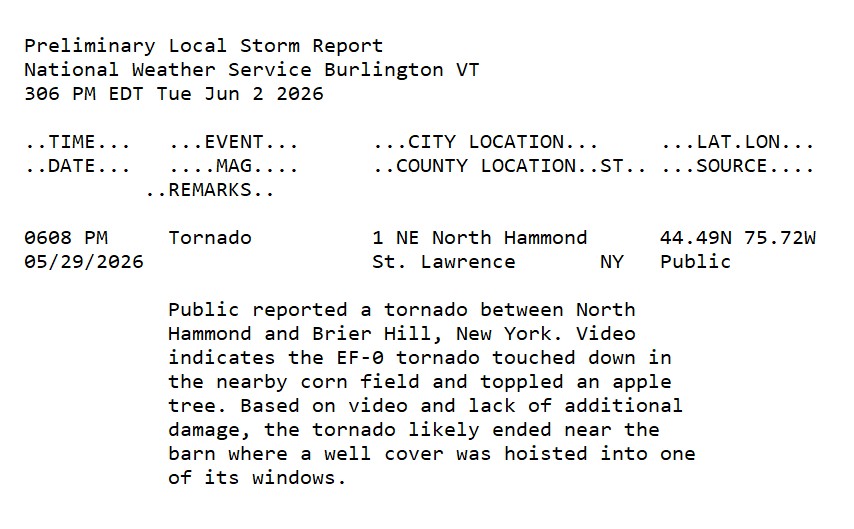
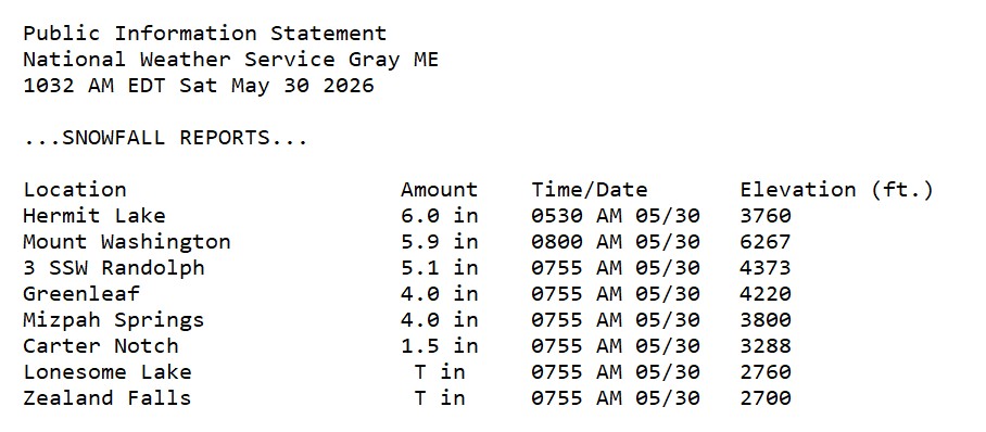
"Scott Spinner" in Upstate NY on 5/29 from the "cold" storm here on 5/30.
-
"A real-time parallel feed of RRFS and REFS will be available on or about July 7, 2026, on NOMADS for both NCEP Web services and NOAAPORT" SCN26-048-Updated_RRFS_and_REFS_Implementation.aaa.pdf
-
"A real-time parallel feed of RRFS and REFS will be available on or about July 7, 2026, on NOMADS for both NCEP Web services and NOAAPORT." SCN26-048-Updated_RRFS_and_REFS_Implementation.aaa.pdf
-
PVA? I haven't heard that term used in some time. Back in the day, it was DA BOMB in wx talk! Not saying it is not important, but just looking at how the lingo has evolved. Now it seems we use UVV, frontogenesis, deformation, and WAA/CAA more for the S+ weenie terms!
-
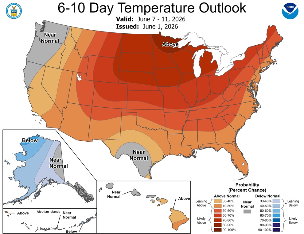
It so easy to be misled, even for learned mets. I would think there is better way to convey temps in the long range. The colors CPC uses are ok, but you go on other sites, and it has been skewed towards warm colors even for cool temps in recent years. It used to be very hot was dark red, but due to the shift up, you now get brownish-red and white! At the same, colors used for cooler temps like the 50s and 60s, are no longer yellow or green, they are shades of orange. This skews perception big time thinking it is "hotter" overall. It's no different that what you see in some TV markets (OKC is one) where they jack up radar reflectivity levels so tstms look "meaner" than for conventional color tables have been used for decades. This has real impacts. I recall during the Iceland volcanic eruption in 2010 that shut down airspace for weeks across the NATL, forecast ash plumes from they HYSPLIT model and others, some would chose these eye-catching bright colors for ash levels/concentration, and you look at it thinking the entire NATL was covered in dense ash! The economic impact here alone can be be understated. it should be standardized colors across all platforms for color tables used so you are comparing graphics apples to apples. The avg person has trouble enough w/ interpreting or understanding wx, so don't make it any more complex that it needs to be!
-
Yes but based on what? 500 mb heights? Do they even factor in marine influences? And objectively, given the surface pattern in this case, it looks more like near normal or leaning below. You have to wonder how much manual adjustment is made, or is it just straight model output averages like the NBM. The public and even some mets don't see these outlooks as probability. They often see the warm color, and think temps will be above avg this period. I've even seen some clueless OCMs state when there is big cold probability bulls-eye present, "the polar vortex will be here!"
-
One thing I notice a lot is the CPC seems to overdo sfc temp anomalies. They see above avg 500 mb heights and just run w/ that. Well, we don't live at 18,000 ft. The 6-10 day outlook looks too warm for much of the E. The 500 ridge axis stays W of the Appalachians, so that promotes frontal passages often in NW flow, strong sfc highs either N/NW or over the area, and frequent sea breezes or synoptic onshore flow. Look at the GFSX MOS from Sunday on, that's below avg temps eastern sections of New England and near avg for western/inland sections at best.

-
Hail falling w/o any rain is quite rare in New England, and the East Coast for that matter, owning to the more moist climate and lack of an EML the vast majority of the time.
-
Incoming for Scott?
-
This happens a lot in the Plains w/ LP supercells as the hail is thrown downwind of the storm. It also happens at times in the Desert SW when the tstm is all virga but the hail makes it to the ground!
-
Nashua actually can be a great area for tstms. In the very active year and hot summer of 1988, Nashua had 15 thunder days in July, and 43 total for the year. Those are numbers near the absolute max, at least for southern NH into central/eastern MA!
-
Yes, I mentioned "embedded convective elements."
-
Sounds like a CoastalWx attitude!
-
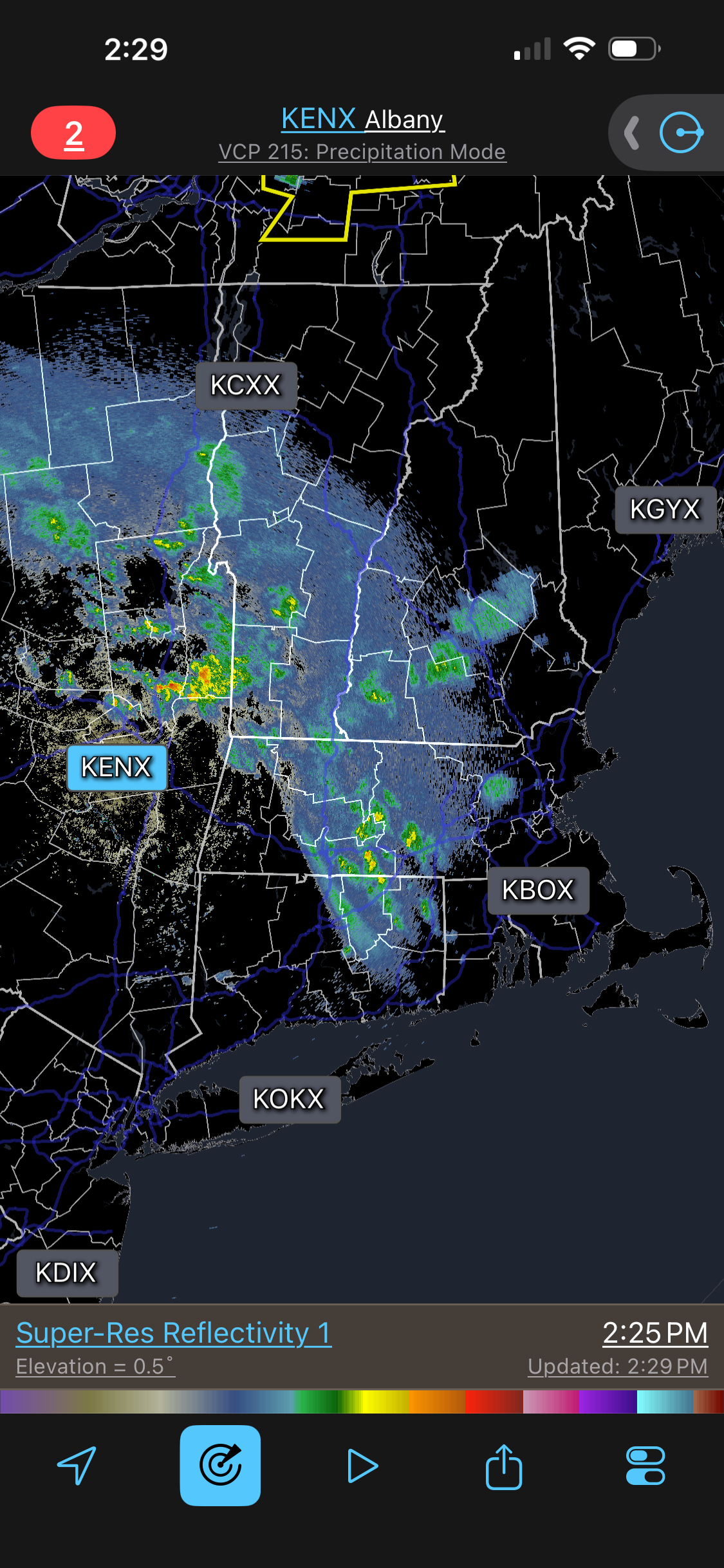
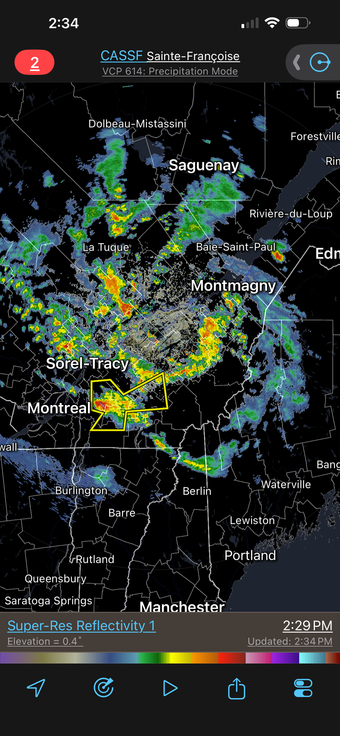
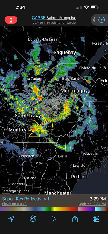
Virga plume ahead of the upper low w/ embedded convective elements. A little odd for an upper low dropping from the N. Nice spiral in Quebec w/ decent tstms. Maybe Scott can get some rumblers in Ossipee!?!
-
Looking at KBED records that start in 1890 I got from a local wx company I worked for in the late 1980s and early 90s, and then using my own records and another's from Woburn (4 mi ENE), only 3 times has measurable snow occurred in May - 1917, 1977, and 2002. 6 other times a trace. 1917 0.3", 1977 9.5", and 2002 0.2" Weren't there flakes in the air in SNE, including ern MA, in early May 2020? This was after I moved to the DC area.
-
HRRR clearly showed at least ern CT was going to have good wind. NBM issue? NBM tends to smooth things out a lot, so it may not handle the more wild/high-end/atypical events?
-
That's what I thought. This late in the season, it is typically either rain or snow. Not that sleet doesn't occur, but typically not in significant amounts or for an extended period. Temps aloft steadily cooled in NNE well as the upper level low moved in, so there should have been no funny warm layers, esp. in a convectively unstable column. Any/all mix should have gone to straight snow in the mountains.
-
Improper wording on my part. It should say, "most of the time" not "always." If you go back months, you'll see the bias I am talking about. Look at his posts about Europe heat in the last few weeks. Why would an OCM that should be focusing on wx local to their DMA or at least the U.S. talk about hot wx/heat domes in Europe? Could it be that there was no sig heat in the U.S. at the same time, so one has to go find it elsewhere on the globe b/c that the "in" thing to hype b/c of global warming? What gets the most clicks/likes and promotes gloom and doom? These tendencies and biases are not hard to spot. All I am saying as a scientist, one need to avoid bias, hype, and report on things w/ balance and reason. When you are a public figure to millions, a responsibility comes w/ that. But you see far too many fall into hype and over-the-top/cheesy statements and graphics just to grab attention and proper perspective, reason, and facts be damned.
-
You'll find far more posts about heat and hot wx than cool/cold wx. Look at the mean/average.
-
-
The fact he is a well-known meteorologist is irrelevant. One being well-known doesn't make one right/better or unbiased. He is at WFLA in Tampa now and has been for at least a year. Take a look at his social media posts. They are over-the-top hype/clickbait, no contest. Always hyping every time it gets hot only, every ridge of high pressure is heat dome, and every anomaly is proof of climate change. Here is an example. https://x.com/WeatherProf/status/2056346965814726858 Having animated flames is hype and unnecessary. And the graphic only focuses on the heat when a large area of cool temps is present and replaces the heat in short order. That is not only hype, it is reporting bias. One should report on *everything*, not just cherry-pick certain types of wx that fit a particular narrative.
-
I was surprised MWN mixed w/ IP the entire event. Soundings by 06z showed it cold enough from the summit and above, yet it stayed mix. So probably funny warm layer still present.
-
Scott's mad it was not directly over GHG!