vortex95
-
Posts
1,488 -
Joined
Content Type
Profiles
Blogs
Forums
American Weather
Media Demo
Store
Gallery
Everything posted by vortex95
-
Yes. absolutely crazy LTG shows. Probably tied to the EML and having "fat" CAPE at mid-levels, so the charge separation is ideal in the mixed phase layer.
-
Not according to CoastalWx!
-
Are their systematic issues w/ sonic anemometers? W/ all the new mesonet sites in MD the last few years, are we seeing wind measurement issues often?
-
Will this convince WxWiz that an EML is not required for SIGTOR? Scott still be like "MEH!" I have a hard time believing that something solid will not occur w/ those dynamics in place in mid-June in the region.
-
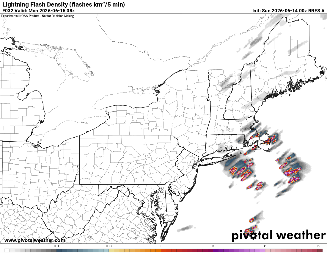
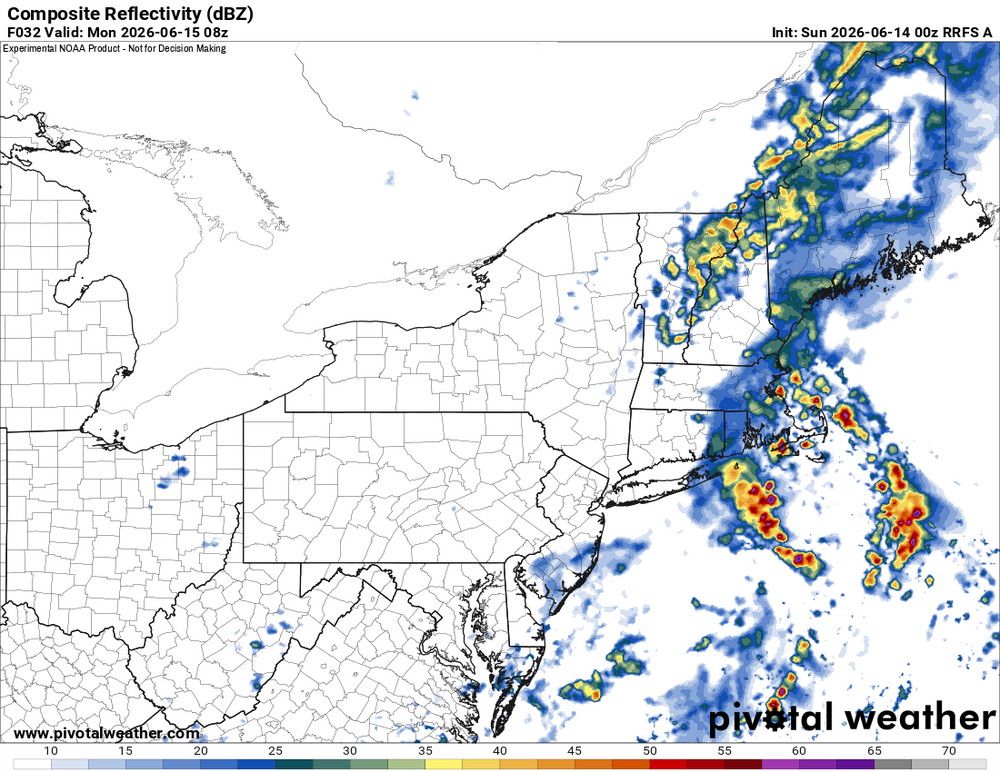
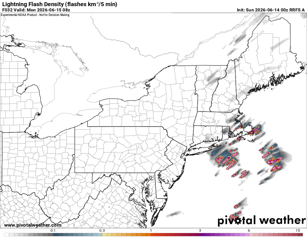
NNE looks good for short bow segments and supercells today. What is interesting is 2-5am Mon in eastern SNE. Nice theta-e noses at 925 and 850 and wind fields 700 and below ramp up nicely just ahead of the well-defined trough axis. 00z RRFS and to a lesser extent HRRR show decent tstms firing ern MA and RI. LTG density is solid. So maybe CoastalWx can get shaken out of bed w/ a +CG super crash! LOL.
-
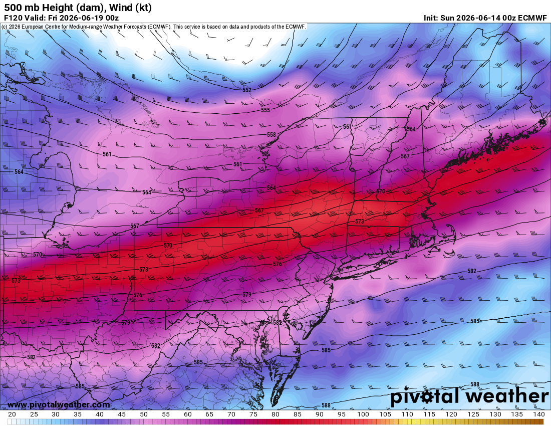
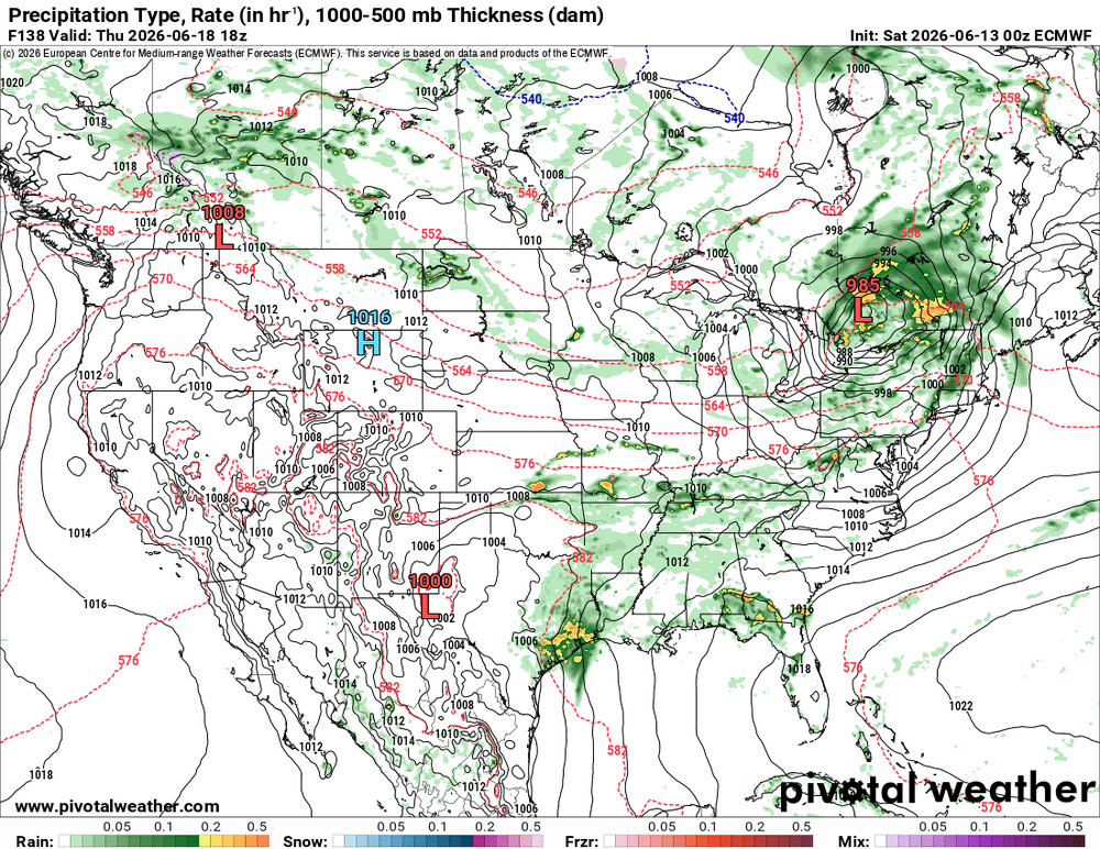
Yes. I see that. Noted on the 00z ECMWF, very strong WAA occurs on Thu during the day with the passage of the WF (that's classic for a big tor day). Nice nose of above avg 850 temp 00z 6/19 (attached). Winds at 500 as high at 95 kt (attached) and 300 winds as high as 115 kt? Tell me something big can *not* happen w/ these kind of wind anomalies and such a strong sfc low in srn Quebec in June! Derecho instead of Scott spinners here perhaps. Looks better to SW of the region. Since set ups like this are rare here, we don't know the full range of possibilities. We may be surprised.


-
I'm originally from just NW of BOS, and the biggest thing I recall locally from that 6/1/11 was the nasty +CGs coming out of the supercell anvils overhead. The storm cores were 30 mi to my W. Don't see that too often in New England! Then another supercell just missed me in the evening that crushed BOS. Here is video (not mine) taken about 10 mi to my N in Lowell MA. This is telltale supercell lightning. Very frequent, quick flickering pulses in the upper part of the CB. You can actually see short cloud-to-cloud bolts at times, known in chaser slang as, "anvil zits!"
-
June 1, 2011 was the New England tor event w/ the EF3 Springfield-Monson MA. This is the last high-end tor event for New England, About every 10-15 years New England gets a high-end tor event, so one could say, "they're due!"
-
When I posted, I thought of it this way, in a overall synoptic sense, you don't track a 990 mb or deeper sfc low across southern Ontario/Quebec this time of year, and *not* have something big happen convectively! What that is exactly is and where? Way too early, but all the main pieces are there, so that's the first step. Work from there. What is really cool now is that modelling and knowledge have come to the point we now can reasonably see high-end/record-setting events potential well in advance. The first time I really took l note of this was a couple days before the Oct 29-30, 2011 snowstorm. I noticed how cold the short-range ensembles were showing the 850 mb temps, and I said, "this is going to be epic/really bad," and look what happened. Then a year later, we saw what the ECMWF was doing w/ Sandy (even before the system was named Sandy!) 9 days out, and again, look what happened! Now we had advanced enough to see high-end svr convective potential days 4-8. From a wx passion standpoint, it's really cool to know such things in advance now. Growing up, I recall the uncertainty factor seemed always so high, and so many surprises (snowstorms over-performing was a biggie). And from a societal POV, us knowing ahead of time is a tremendous benefit so we can prepare for them and mitigate impacts.
- 1,481 replies
-
- 2
-

-

-
- severe
- thunderstorms
- (and 7 more)
-
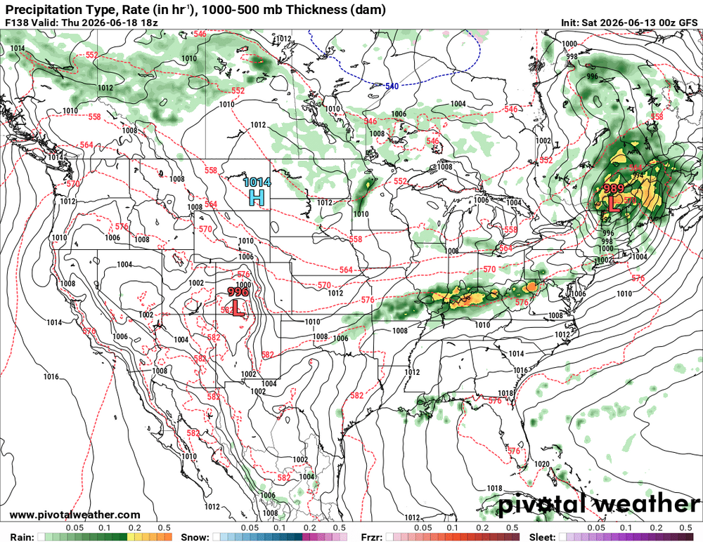
SPC DY6 has SVR outlooked OH Valley-DCA-NYC? Time for WxWiz to starting getting ready. He been waiting for something like this for so long! And CoastalWx can stop saying "SNE SUCKS for convection!" LOL. From pattern recognition, I am very impressed, and it takes a *lot* to impress me for svr these days. An unusually strong sfc low for mid June is fcst (below 990 mb) to track across southern Ontario and Quebec. 00z GFS and ECMWF same idea on 6/18 for wind fields -- GFS a bit stronger than the ECMWF, but does not matter, they are still through the roof for this time of year. GFS 120 kt 250, 95 kt 500, 75 kt 700, 65 kt 850 and 925 in New England this time of year w/ available CAPE this time of year? Ho-ly ( )!!! Actually, w/ these kind of wind fields, you don't need more than say 2000-2500 CAPE for sigtor. Anywhere from the OH Valley-Mid Atlantic-Northeast may be in for a sig tor event! I don't have to quote the big tor outbreak for our region, but just mention July 10, 1989, and WxWiz will faint! FYI, winds of 65 kt at 850 existed for the ORH 1953 event. For the July 10. 1989 event, the sfc low that tracked across NNE was "only" 998 mb. Not overstating things here for potential at all. But of course, it's all in the details. *But* again, SPC outlooking SVR this part of the country on DY6 this time of year? That says something! You don't get that w/o a synoptically-evident set up.
-
The DY6 SPC outlook? It is definitely warranted. An unusually strong sfc low for mid June is fcst (below 990 mb) to track across southern Ontario and Quebec. Wind fields are clearly high end for this time of year. GFS and ECMWF same idea on 6/18 -- 70 kt 500, 60 kt 700, 50 kt 850, 40 kt 925 over Mid-Atlantic. That means business and this time of year w/ higher CAPE? Anywhere from the OH Valley-Mid Atlantic-Northeast may be in for a sig tor event June 23, 1944 comes to mind so does June 8-9. 1953. Also July 10, 1989 (New England's largest single day tornado outbreak for number of tornadoes). Derecho not out of the question. Svr mode is up in the air at this range. Not overstating things here for potential at all. But of course, it's all in the details. *But* SPC outlooking SVR this part of the country on DY6 this time of year? That says something! You don't get that w/o a synoptically-evident set up!


- 1,481 replies
-
- 9
-
-

-
- severe
- thunderstorms
- (and 7 more)
-
And moist adiabatic lapse rates to 550 mb...EEECH!!
-
So I did a little easy "experiment." Using CoCoRaHS sites, I got Y-T-D totals for the 3 sites closest to Logan. Chelsea, Somerville, and Nahant. Chelsea - 15.26" Somerville - 12.72" Nahant - 12.55" And BOS? 10.79" Again, taking climate information at face value has its issues. The excuse here? "Oh, we have to use it b/c it is official!" So? Just b/c it is official does not mean it is correct/right. That's the appeal to authority logical fallacy. Equipment/standards/practices are not perfect, so calling such out is not wrong.
-
A couple things to note. The readings were taken in the city before Logan was built, so that's one factor. Prior to 1980, the temps were taken tucked back a bit near the WSFO, and since, the sensors have been located in the middle of the runways solidly surrounded 3 sides by water. This is going to result in upward trend in dews long-term. Another factor, going to from glass to digital thermometers. Digital can record instantaneous quick temp/dew changes. ASOS is supposed to do 5-min avg to mitigate this. It is known that digital temps run a bit warm compared to glass thermometers overall. Not sure about dews, but it is something to consider. ASOS is considered accurate as long as the temp sensor is within +- 2 F. Not sure about its dew sensors, but yet another thing to consider. A margin of error here would suggest that the approx 1 F dew rise since 1995 when the ASOS was installed at BOS can not be considered statistically significant. How does the increasing heat island effect over time impact BOS dews? As you can see, there are a number of non-meteorological factors that have zero to do w/ climate or its changes that can and do give false trends either way. You can't just simply take climate records over long period of time at face value due to factors mentioned above. So I would use caution w/ small trends over many decades and longer.
-
The price he pays for having nearly 177k posts! I didn't make ACATT.
-
The surging satellite appearance of the storms Thu reminded me of a tropical squall line. Mesoscale factors, such as the cool pool, are the driving force due to lack of winds aloft/deep layer wind shear.
-
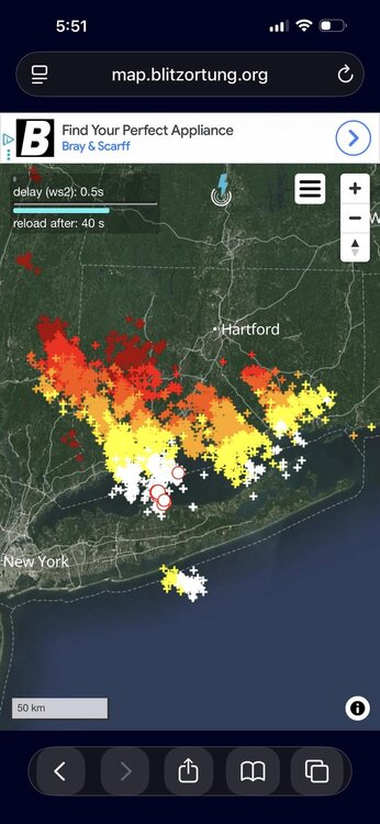
Wxwiiz mad he missed this??? CoastalWx proby just MEH! LOL. Look what happened Thu just over the border in Pauling NY. Hail up to 2" in diameter. https://www.facebook.com/share/p/1E8jBs32e1/ Video of hailfall: https://www.facebook.com/watch/?v=999500782484311 Serious wind damage right over the CT border in Quaker Hill NY. https://www.facebook.com/share/p/1TsM5ejxkj/ NW flow delivers! The LTG plot reminded me of July 10, 1989 a little. Also, June 20, 1995. See here: https://www.nbcconnecticut.com/news/local/remembering-the-1995-hail-storm/16546/
-
And here we have yet another factor that misleads. Bad data and using a single point!
-
There are 4 types of drought: - meteorological - agricultural - hydrological - socioeconomic All go into the drought status monitor we see, but it can me misleading. For instance, two of the factors have nothing to w/ actual precip. Agricultural and socioeconomic deal primarily w/ land/water management (or the lack of) and demand over time from increase population/infrastructure (data centers anyone?). And it goes one step further within the categories. You can have plenty of rainfall, but a lack of snowfall, so the reservoirs and lakes are full and water table high, but snowpack is below avg. And keep in mind, the current U.S. Drought Monitor we look at weekly w/ its current standards and guidelines did not exist prior to 2000. So that is not long enough to determine trends either way. What we call drought and how we measure/categorize it has changed over time as well. From my observations long-term, the U.S Drought Monitor has a tendency to overdo it, and it is misreading b/c most ppl just think lack of precip for drought, when it is much more complex than that.
-
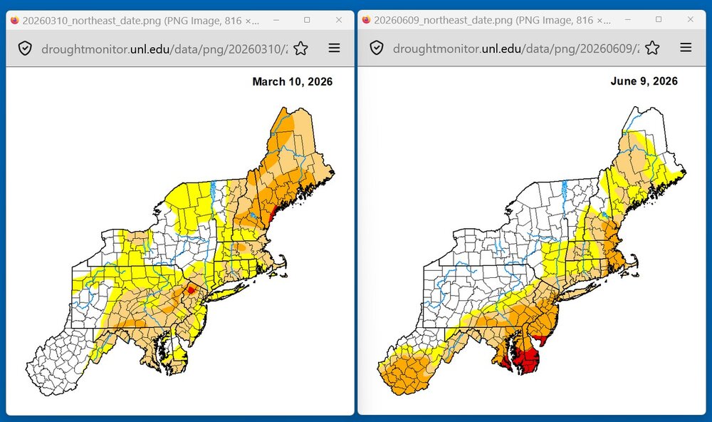
MSM cherry-picking again. Sure you have svr drought SE NH and ern MA, but that is just one local area. Take a look at the drought status 3 months ago compare to this week for the NEUS and Mid-Atlantic (attached). Overall improvement for the NEUS and Mid-Atlantic. A large area of svr drought is gone in NNE. Yet you get ppl just focused on one small area, not telling you the larger picture. SE NH and ern MA do not exist isolated. Watersheds flow into this region, and if adjacent watersheds in decent shape for precip, then that mitigates things downstream. The term "drought" is treated as singular and simple term. It's not like that at all. But some never let the details (or key facts) get in the way of a particular narrative (all gloom and doom and the end is nigh). The MSM narrative is to push drought all the time, as if it never should occur, any that occurs is unusual, and we can't handle it as society, never mind it is just one more thing to hype to scarce the public for ratings. Drought exits in the U.S 10-15% of time on avg, and it waxes and wanes in irregular cycles. This is not cause for alarm in itself. The NEUS and Mid-Atlantic have not had a multi-year drought since the 1960s. How is that possible if droughts are getting worse w/ time everywhere? Short-term droughts are common and par for the course. If you want to see a deep dive and analysis about how drought conditions and declarations are misused and abused, take a look here about conditions in WA currently. The morale here is that there is more to the story. https://cliffmass.blogspot.com/2026/05/the-is-no-drought-emergency-in.html https://cliffmass.blogspot.com/2026/05/why-washington-drought-emergency-should.html
-
You do realize that cooler can mean a lot of tstms and SVR!
-
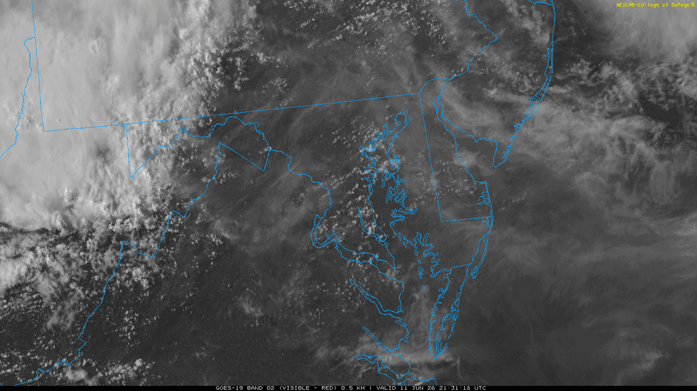
Good that you noted the satellite presentation. One thing that *really* stands out to me and is atypical for a svr wx day here -- the storms had zero anvil-level flow. No glaciated anvils spread out anywhere upwind or downwind of the updrafts! It's just a series of "updraft puffs," so to speak! So upper-level winds were lacking as well. No "venting" of the updrafts, not good for sustained storms. This perhaps explains a lot why w/ such high CAPE the storms failed to realize their full potential! I attached a VIS GIF loop from 2130z to 2330z. Also, you can clearly see how outflow dominated the storms were almost from the start. And look at the high clouds over the Delmarva. Moving S? The ridge axis at 250 mb at 00z extended from about BGM to CAE. You don't want ridging aloft directly over the area of interest for svr wx! This also explained why the storms had no spreading anvils. So yet another item to throw in that messed things up! Yet many wind reports, so it wasn't a bust in terms of the slight risk, just some details were off, like lacking a lot LTG and more outflow dominant that you would expect. Actually, a pretty fascinating case looking at the details, and why things did what they did. It's important to look at why things fail in expectations, not just why things exceed expectations in fcsts!
- 1,481 replies
-
- 6
-
-
- severe
- thunderstorms
- (and 7 more)
-
Yes, the little details count when it comes to svr wx events. *One* thing off, and it can be the difference between several tors or none, or several intense, long-tracked tors or a bunch of weak, short-lived ones. For instance, sfc dew points are a few degrees lower than fcst. This raises the LFC, and lessens 0-3 km CAPE, which are key for tors. How many times does it look good "on paper" for big svr wx, and it fails. SCP and SIGTOR are high, and it's a major disappointment and under-performs. SCP and SIGTOR can't account for everything going on, they account for just some. They can't be treated in a vacuum! Of course, the door can swing the other way. How about June 5, 2024? That was a surprise! Yes, SPC had 2% tor risk, but it did not stand out as "big" for tor event in this area. It was not synopitcally-evident. And we got what, 13 tors? And they were not all just brief spin ups!
- 1,481 replies
-
- 3
-
-
-
- severe
- thunderstorms
- (and 7 more)
-
Thanks. 0-6 km shear was only 15 kt at IAD, well below the threshold for marginal supercells (30-35 kt), so storm lacked mid-level mesos. All you need is a half-decent meso at mid-levels, and that makes storms *so* much "better." Even if no severe wx, the LTG and rainfall ramps up! 0-8 km shear was even weaker at 14 kt. And look at hodograph, it is a chaotic mess! Tons of CAPE only takes you so far. If the shear is lousy, it's hard to sustain discrete, long-lived cells. I'd take 1500 CAPE and 0-6 kt shear 40-45 kt anytime over 3500 CAPE and 0-6 shear 15-20 kt! The presence of good wind shear also prevents storms from gusting out too easily. The updraft and downdraft couplets in the storms are separated better in a higher-sheared environment. I realize some already know this, but this is a very important point when it comes to mesocyclones. The presence of mesocyclone just at mid-levels (low-levels can be nothing) greatly enhances the potential updraft strength of a tstm. It can double the updraft strength from buoyancy (CAPE) alone though dynamic pressure perturbations, so that's why supercells have such intense updrafts. 1500-2000 CAPE may not sound like much, but if the shear is ideal, holy cow. For instance, the April 1965 Palm Sunday Outbreak in the OH Valley, CAPE was 1500-2000, and the 0-6 kt shear was about as high as I have ever seen it for an outbreak. It was 100-110 kt! That's crazy, and you had a lot of intense, long-tracked tors.
- 1,481 replies
-
- 1
-
-
- severe
- thunderstorms
- (and 7 more)
-
As noted in previous posts, odd for temps in the 90s and DPs 70 It acted more like a cool season line of gusty heavy showers. 00z analyzed NAM 1000-500 thk for DCA was 577, so that usually means 50k CB tops easy and lots of LTG. Peak mid-level lapse rates on the 00z IAD sounding were 7.0 C/km between 700-500 and CAPE at mid-levels was "fat." That should have lead to solid charge separation in the supercooled water level for lots of LTG. K-index 36, so not dry aloft. Sfc T-Td spreads around 25 so not too dry at low levels. Yet things were very outflow-ish. Storm cores should have been "meatier" for the lack of a better term! The thing that stands out in the sounding is the lack of solid deep layer shear, so that likely precluded stronger coherent cells or a more solid/thicker SQLN.
- 1,481 replies
-
- 4
-
-
-
- severe
- thunderstorms
- (and 7 more)