vortex95
-
Posts
2,209 -
Joined
Content Type
Profiles
Blogs
Forums
American Weather
Media Demo
Store
Gallery
Everything posted by vortex95
-
In marginal or so-so conditions, a system can get organized quickly when it comes to a LLCC and the TD/weak TS stage, but true RI going 25-30 kt in 18 hr is a significantly more of a challenge or unsure. I'd more concerned about RI here if the environment was marginal due to mdt shear and surrounding environment was sufficiently most as that can lead to RI in some cases. See here: https://journals.ametsoc.org/view/journals/mwre/146/11/mwr-d-18-0020.1.xml
-
Yes, you can get mid-level eyes appear even in the TD stage. In this case, since there is no deep convection over the center, it is lower-level feature w/ shallow convection around it that makes it look like an eye. Look at the platform obs to the SW. NE winds? Talk about a small circulation! The small TC for rapid intensity changes is tricky. A small TC is more sensitive to dry air intrusions or shear than a larger one, but at the same time, having a small RMW promotes RI easier. Mesoscale factors in the inner core come into play, and are very tough to fcst. Recall HU Oscar a few years ago? That had one of the smallest RMW for a Atlantic HU on record and models had no clue!
-
IMHO, I think they are really pushing the limit for HU watch here. Yes, the pressure is down, but the convective area waned considerably at the time until about an hor ago, yet NHC did not even acknowledge this clear cycle down on sat? Again, I think they tend to not include if they can anything that show weaker or a struggle, but as posts noted on the thread in the last few hours, Edouard looks not so good (skeletal). So I am just speaking out loud here what others might be thinking as well and not thinking in an isolated vacuum! Yes, the risk is there, but err'ing on the side of caution I find influence more by social pressure rather than sticking to the met science these days, which has advanced big time over the decades. And, yes, I am aware of what HU Humberto did in Sep 2007 in the very same area, but that was an exceptional event, no other like that on record, so that alone is not enough. Also objectively, current environmental conditions concerning dry air are a sig problem as evidenced by the wane of convection earlier and what we see just to the N on the mid-level WV, so that would count against such aggressive RI. All I am saying is that the door swings both ways here, so in Edouard's case given the factors, IMHO would be more logical/practical to split it down the middle (steady but more modest straightening). rather than chose any one clear direction until we actually see evidence of RI. esp on satellite/radar and it being in a data rich area. It's not like we will be in the dark as to trends hour-by-hour. Lots of platform sfc obs off the LA coast, as one example. I know I am verbose and sound pedantic, but it shows how there is a *lot* to consider in TC forecasting, and forecasting in general. How one chose to go in any given situation is subjective of course. My position is that I do not go high aggressive in a forecast until I see clear reason to do so ((in other words, not forecast an outlier, rare, or exceptional event unless it is clear it has a good chance of occuring), and the amount of wx data and its detail these days, one can afford to "wait and see" more IMHO.
-
Some get *far* to impressed w/ large MCS areas w/ very cold cold tops for nascent TCs. Yes it is intense convection, but that does not correlate well when it blows up very fast b/c that often mean it will dissipate just as fast. And the collapsing convection hinders organization at low-levels, .It can also happen when a system of mdt TS status. You get this immense area of very cold cloud tops, sometimes below -100 C, in a rather symmetric blob, calked a CCC, but there is no banding. When this happens, the TC often is stunted in intensification until the CCC feature goes away. If Edouard has a blow up of convection overnight, watch closely, Does it form in a coherent band as we are seeing on the N side now, or is is just random blobs (zits!) expanding radially? Also, you can have a combo of this. Banding now on the N side is good, but nothing on the S side, This implies dry air wrapping in. Also, the banding on the N side may be due to frictional convergence from the LA coast. Still, that can increase max winds b/c the stronger convection mixed down higher winds aloft better and the band is pushing against weak high pressure to the NE
-
As hurting as the convection is, at least it is nicely circularly-banded and looks more like a classic TC. Did not have that at all w/ Arthur, Bertha, Cristobal, or Dolly. Shear was the big issue for those. Edouard's issue is dry air, but you can do a bit better overall for max TC intensity when only dry air is an issue I have noticed empirically.
-
Yes, NW flow events are *notorious* in New England for its biggest tor events and outbreaks. Historically, it is a little less defined in the Mid-Atlantic b/c it does well in SW flow (College Park, Sep 2001) and TC events (remains of Ivan in Sep 2004), but you have June 23, 1944 (WV hit hard) and June 2, 1998 (Frostburg MD F4). https://www.weather.gov/lwx/events_19980602 https://www.tornadotalk.com/june-2-1998-tornado-outbreak/ And, of course, the derecho on June 29, 2012. I think an EML present is important for high-end derechos.
-
I have only lived in the DC area for 8 years, and I am still trying to get an overall feel for local nuances when it comes to tstms, esp. when the "DC split" occurs. That seems more than just a random coincidence. And it is apparent the corridor from about 30 mi W of BWI to the city is a favorable area, so is just E of I95 to the Delmarva, and it seems really apparent CHO-RIC-ORF area in terms of a "hot spot!" Also, w-cntrl and swrn VA get some really nicely-structured supercells at times!
- 2,604 replies
-
- 1
-

-
- severe
- thunderstorms
- (and 7 more)
-
"Boring?" Good to see you post elsewhere, not just always on the Weymouth MA...er, I mean New England forum!
-
Tiny sucker!
-
1010 mb for a c.p. is pushing it for TS-intensity objectively, but Edouard's small size means a tighter gradient hence stronger winds than you would normally expect. Andrew N of PR in Aug 1992 when it was struggling against against an upper level low has a 1015 mb pressure per recon and they still found near hurricane-force winds at FL!, so they kept it at a 40 kt TS, but one could argue it opened up as a trough for a time. You can see dry air entrainment is still an issue (SHIPS diagnoses 700-500 RH of 48% -- anything less than 60% is not good) w/ a sig waning of the deep convection in the last several hours. I am not sure why NHC does not explicitly mention dry air as a mitigating factor. Sure the shear is low and SSTs high, but you need all three solid/favorable for steady intensification or RI. We saw this w/ Lala. They kept saying "conditions generally favorable" repeatedly w/o going into the individual factors, such as dry air to the N and NW w/ a stable stratocumulus field. Yes, Lala intensified, but only slowly. My point is we can do better for details when diagnosing and pronosticaing a TC. Sometimes I think they hedge slightly to avoid anything that makes a system less of a threat on a perception level. I say, tell it like it is in detail objectivity based on the met science alone, no bias either way! And ppl (esp. wx weenies!) want such details I have found since it is not "one-size fits all" for TCs. That's how everyone learns! The finer points and details on wx phenomena that are not immediately apparent or well-known I find the most interesting.
-
I don't know, Many times in WNW or NW flow, mountains to the W do well, then is often a gap due to downslope flow between IAD and DCA, and then it picks up again due to the bay breeze and higher dew points E of I95, But its not easy tell on any given days the "DC split" occurs, and w/ an EML present, that makes it more complex b/c nighttime convection is more common and often not surface-based, so downslope flow is not as much of a factor.
- 2,604 replies
-
- 1
-
-
- severe
- thunderstorms
- (and 7 more)
-
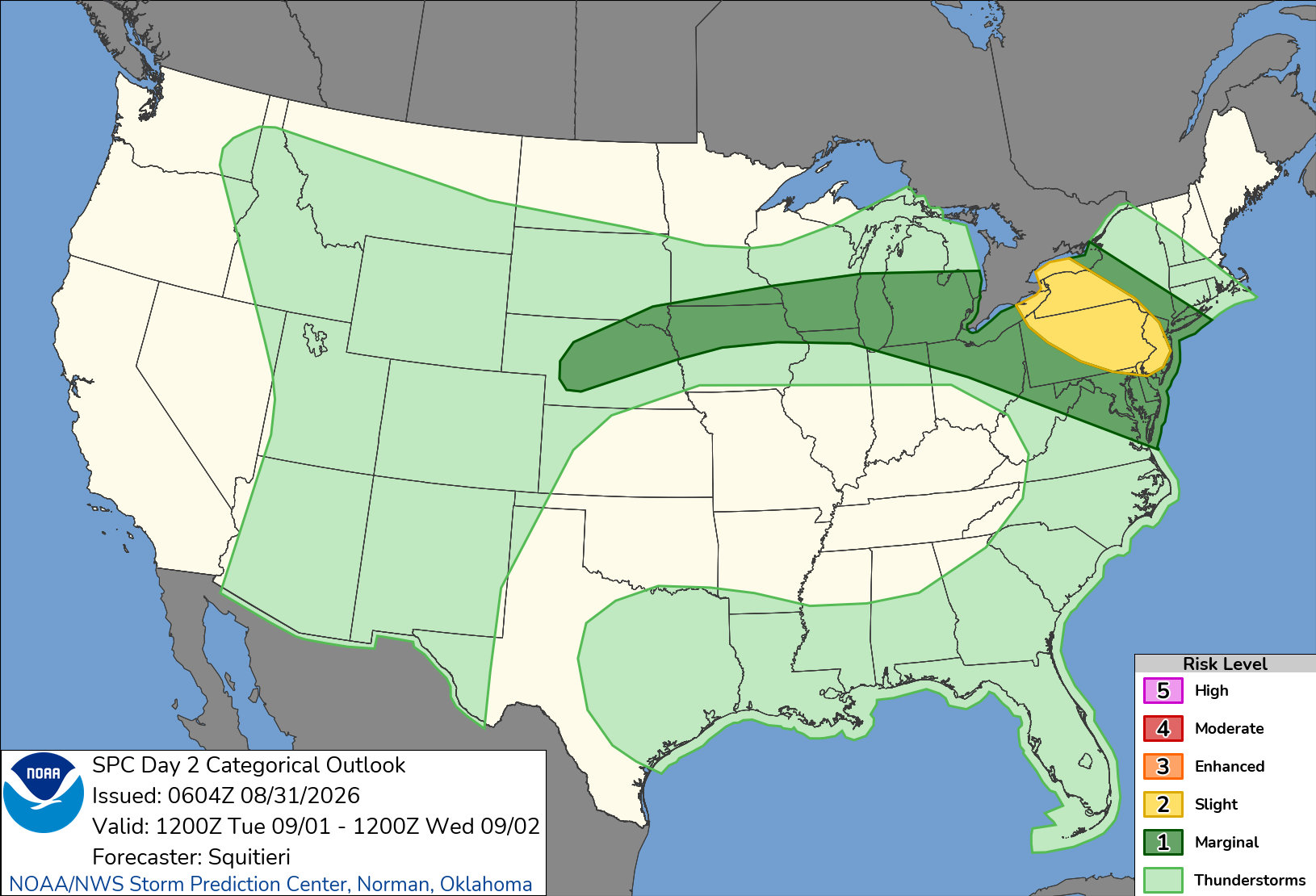
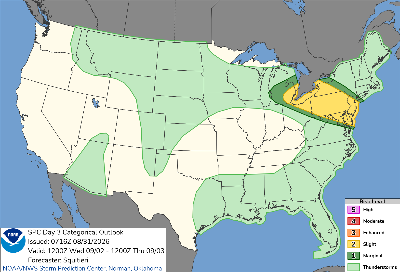
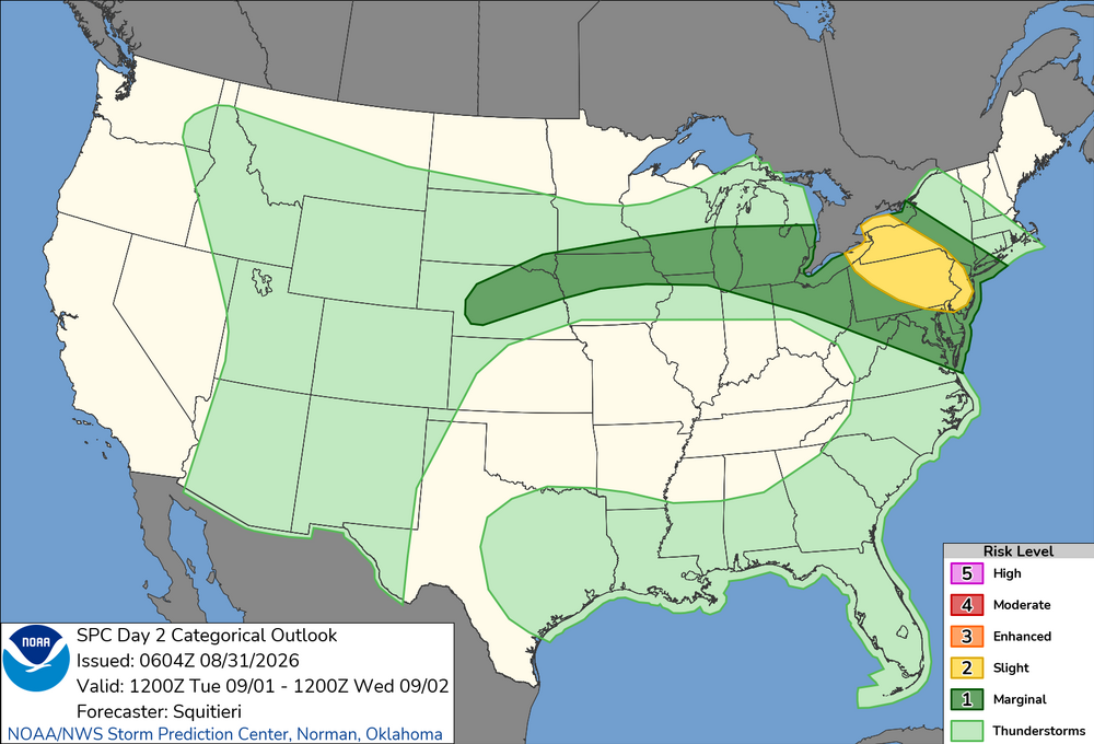
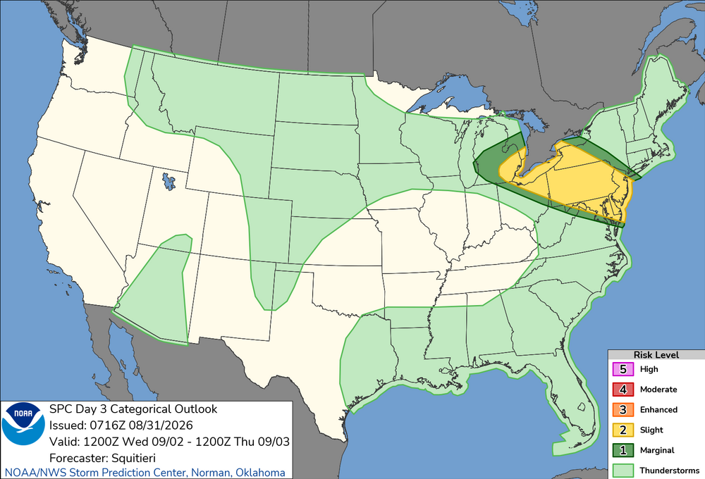
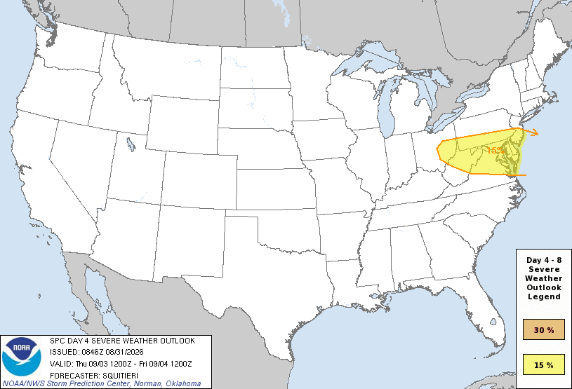
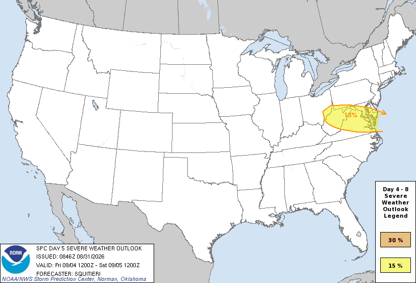
Four days in a row svr risk in this area, esp. this time of year? Sure ,lots of days get upgraded to slight risk the day of and we get 4 days in a row of svr risk, but to have days 3, 4, and 5 outlooked means synoptically it is defined and impressive, which means higher-end svr wx possible. Usually in this part of the country, you don't get multiple days in a row w/ svr wx from NW or WNW flow b/c one wave of convection and it s/w trof clears things for moisture, and it takes a bit of time to recover. Or the front/boundary gets pushed farther and farther S w/ each wave of convection. But the way the mid and upper level ridge is during this period looks like it may force things to be in the same general area repeatedly. Why not? Every so often things do work out for relentless stormy wx in a region! One might say, "4 days in a row, *everyone* should cash in and get crushed at least once during the period!" I hope so. W/ an EML present, you can do some nice things during the overnight hours, esp. with crazy LTG.
- 2,604 replies
-
- 5
-
-
- severe
- thunderstorms
- (and 7 more)
-
Augdewst 2026: Summer's Last Stand
vortex95 replied to Prismshine Productions's topic in New England
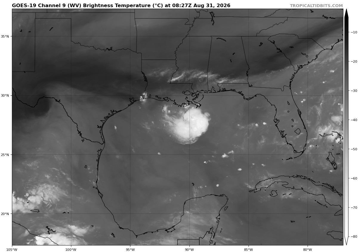
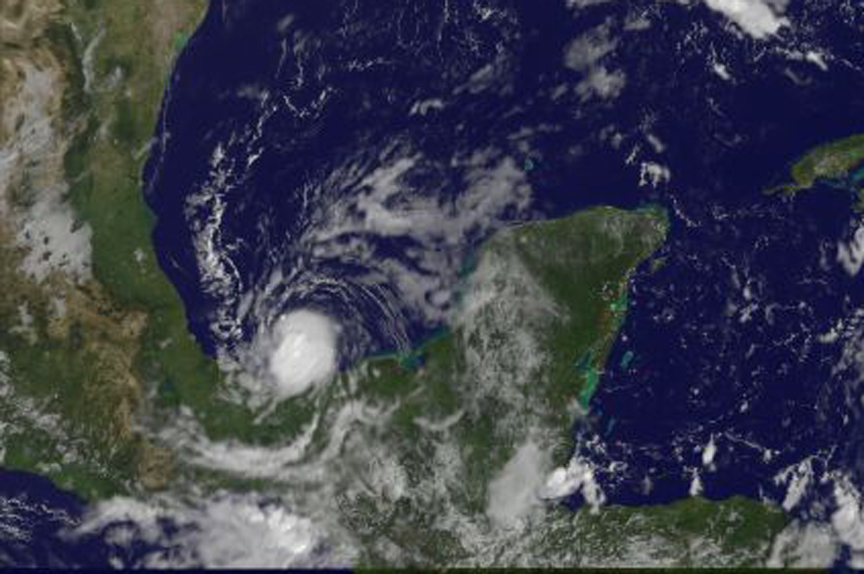
Invest 97L -- if this system makes TS-strength, it is likely to be among the smallest TCs on record. Compare the WV image of 97L currently to an image of Macro from Oct 2008 in the Bay of Campeche, which is the smallest TC on record (both attached). The small size is a product of how unfavorable conditions are in the Atlantic overall for TCs. Yes, in the Gulf the shear is low (unlike the MDR) but mid-level dry air is an issue. Nary any other convection in anywhere near 97L! @CoastalWx will say, "still does not break the BORING pattern!!!" But wx always has something KEWL going on if you do not confine yourself w/in 5 mi of Weymouth!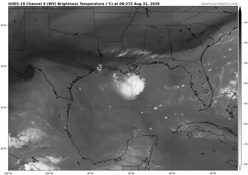
-
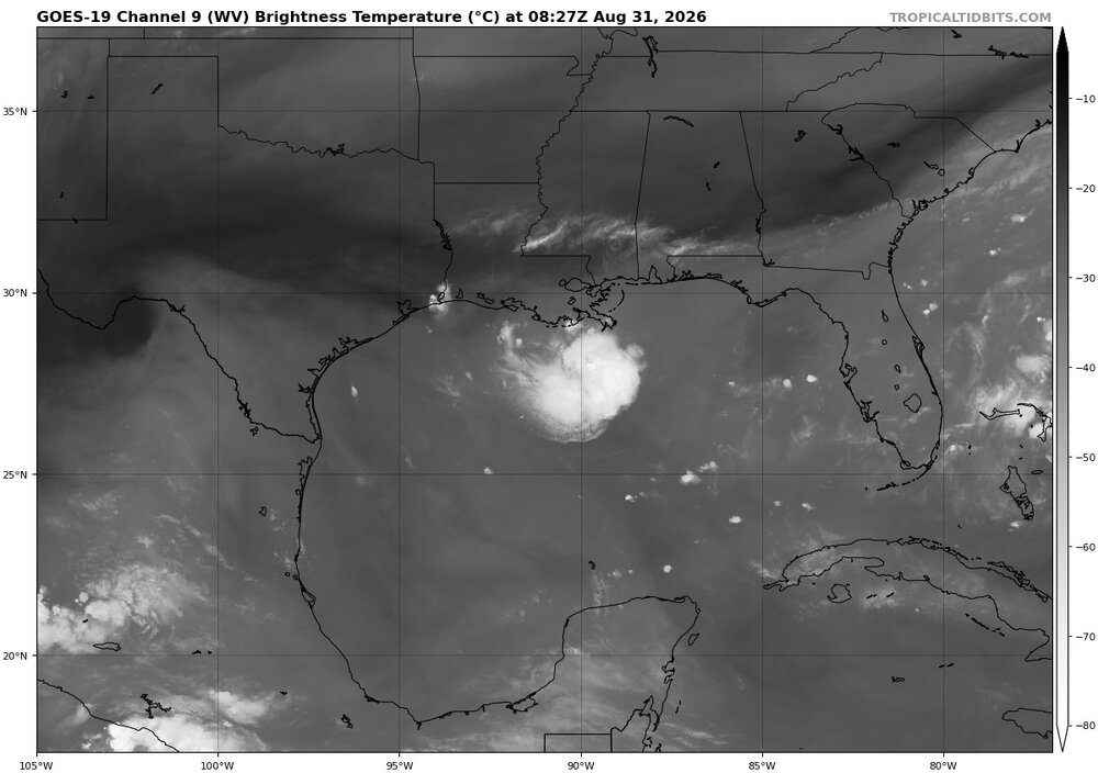
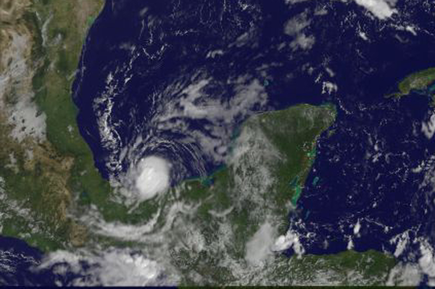
Also, 97L is *tiny*. In fact, it is not that much larger in convective coverage now than smallest TC on record -- Macro in Oct 2008 in the Bay of Campeche. I attached a current WV of 97L and image of Marco. The small size is a product of how unfavorable conditions are in the Atlantic overall for TCs. Yes, in the Gulf, the shear is low (unlike the MDR) but mid-level dry air is an issue. Nary any other convection in anywhere near 97L!
-
I think they are holding off on PTC b/c it is not clear it will be a TS before landfall. They do not want to put up TS warnings due to this uncertainty b/c of the impact alone warnings have. It puts things different level from a EM standpoint and business/commerce. 97L looks better on sat and radar as I type this. Will they declare it a TD or do PTC by 5am?
-
The sensible wx impacts from a strong tropical wave can be just like minimal tropical storm. That's the challenge faced by NHC and other wx services at times b/c the public mostly cares about/sees the impacts, not scientific definitions. But we can't just arbitrarily call something this or that b/c it has wx that appears mimic something else! A typical baroclinic cold core low pressure over the open ocean, many easily have winds of a Cat 1-2 hurricane, and pressures below 920 mb in extreme cases, and overall power as much as a Cat 5, just the wind energy is spread out over a much larger area
-
The convection is still strongly pulsing, and NHC likes to wait to see more persistent and coherent convection or decent circular banding before declaring a TC, which is a good mode IMHO. Quickly waxing/waning convection is a sign of dry air or shear, and pulsing the convection results in cool outflow boundaries that interfere w/ the organization of the LLCC. It is also a very small system, and small systems are more susceptible to environmental factors. In this case, lots of dry air just to the N that can get entrained easily. Looking at the 00z SHIPS output for 97L here, you can see the 700-500 RH is quite low. (below 50%). https://hurricanes.ral.ucar.edu/realtime/plots/northatlantic/2026/al972026/stext/26083100AL9726_ships.txt
-
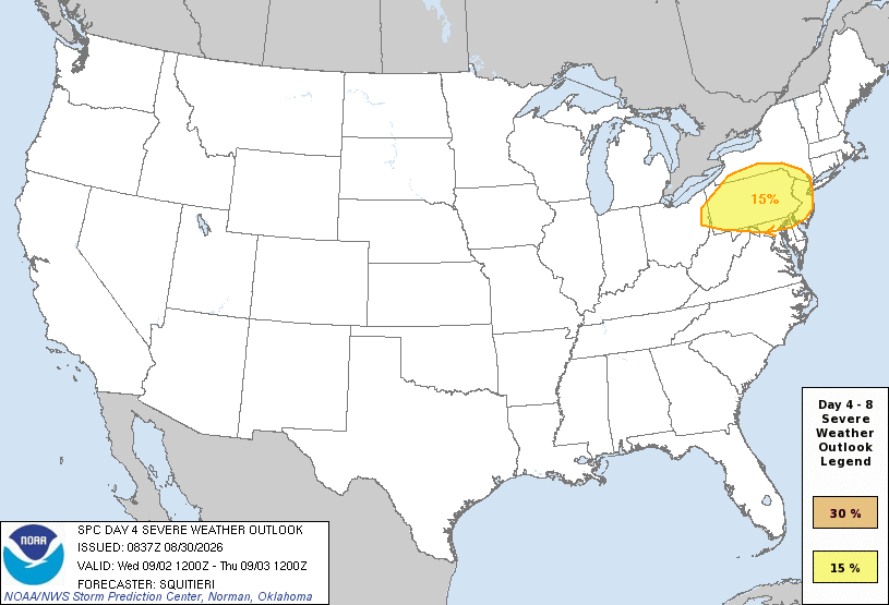
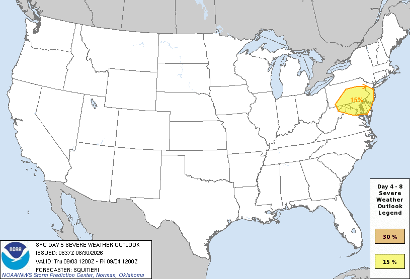
Looks like a multi-day event coming for the region. SPC even mentions svr risk on DY6 psbl! Hot upper ridge w/ axis to our W in WNW to NW flow and we are on the edge of capping and stronger flow aloft. Can do quite well in such set ups due to an EML! Highest risk and axis just N now is actually good b/c many times initial convection pushes the boundary farther S than any model shows, so that may place it right over the region instead. We saw this a few weeks back except everything was pushed well S into the Carolinas and we missed out on a multi-day svr event in the DMV.
- 2,604 replies
-
- 8
-
-

-
- severe
- thunderstorms
- (and 7 more)
-
Augdewst 2026: Summer's Last Stand
vortex95 replied to Prismshine Productions's topic in New England
@weatherwiz and @CoastalWx are "mad" it is all SW! SPC even said DY6 could have svr in the same area! -
Yes, the convective mass is impressive w/ very cold cloud tops. but it is amorphous and rapidly pulsing. This indicate lots of shear and/or dry air, which promotes regular severe convection, but it detrimental to TC formation/development. We saw this w/ Bertha when it was on the LA coast and intense mass of convection well S due to strong shear. Look at the loop attached for Ex-Dolly this morning. The convection is "ripping" linearly E to W on a trough line. No circular motion or banding at all. That is not a sign of overall intensification as a TC. Sure, there are gale force winds easily in that severe convection, but that is mesoscale and transitory, not pressure gradient driven on a larger-scale, which what you look for a TC. Basically, it does not fit the requirement of a TC, which is a coherent, closed low-level wind center w/ persistent convection. Yes, you can still have shear and dry air present and have a TC, but this is not the case here b/c synoptic conditions are so unfavroable. It as a strong tropical wave, it can thrive when it comes to intense convection, but lack organization to fit the definition of a TC. Generally you do not want to see rapid blow-ups of convection for TC development/intensification b/c it often pulses down quickly and leaves cooler, low-level outflow soundbites from collapsing convective towers (including downbursts), that radiate away in a divergent pattern, which prevents or weakens any low-level circulation. You see this is often in sheared systems in the form of fine-line line outflow boundaries moving away from the center on VIS. Circular banded convection around a center that has not as cold cloud tops is much better to see on satellite for a TC than what we see for ex-Dolly now.
-
2026 Atlantic Hurricane Season
vortex95 replied to Stormchaserchuck1's topic in Tropical Headquarters
It makes you wonder prior to the satellite era and modern practices, season that were record quiet, like 1914 (one storm), It is highly likely there were some others just like we have seen this season so far. Short-lived, weak TSs that we simply did not have capability of detecting them well or at all way back. But it does not really impact the climo, at least when you go by ACE. 10 weak, short-lived TSs don't even come close to a single, long-tracked, intense Cabo Verde hurricane for total ACE! -
2026 Atlantic Hurricane Season
vortex95 replied to Stormchaserchuck1's topic in Tropical Headquarters
Having an exceptional pattern the other way (i.e. very inactive) is of high value b/c it allows us to see the absolute extremes at the other end and what goes on literally that causes it. Sure, we know very strong El Nino does this to the Atlantic, but not every very strong El Nino is the same and we only have 4 other El Ninos since 1950 on this scale, so odds that when this El Nino is done, we will have witness patterns we have not seen before in the satellite age. Knowing what suppresses TCs I would argue is just as important as to what favors them. And 2024 and 2025 w/o El Nino, we had some previously unseen patterns that ripped the heart out of the peak climo part of the season and resulted in busted over-forecasts. Either it was unusually strong and persistent SALs/TUTTs or the ITCZ displaced unusually far N into the Sahara, and brought to light was the "Atlantic Nina" and its possible role! -
Augdewst 2026: Summer's Last Stand
vortex95 replied to Prismshine Productions's topic in New England
For @weatherwiz it always come back to the EML in the end! Well, the West Stockbridge MA F4 Aug 28, 1973 tracked NNW to SSE, so odds are *big* EML then. -
Augdewst 2026: Summer's Last Stand
vortex95 replied to Prismshine Productions's topic in New England
Yes, the state of the MDR is exceptional currently. Dry air and shear reign supreme. Look at the SAL image of the remains of Dplly attached. That dry air wrap that far S (goes to 5 deg N) this time of year? Ugh. -
Augdewst 2026: Summer's Last Stand
vortex95 replied to Prismshine Productions's topic in New England
If you were talking in jest from the start, that was not apparent to me. It is very hard at times on social media to detect tone, inflection, and mood (compare to in-person) esp. when it comes to topical or sensitive issues. It can be a minefield and leads to unnecessary conflict. And we all have been there and are susceptible. So I apologize for the improper response. It was not done maliciously or in spite, just I was trying to clarify my position and what was trying to say w/o letting the conversation devolve, which is challenge in itself many times!