vortex95
-
Posts
2,210 -
Joined
Content Type
Profiles
Blogs
Forums
American Weather
Media Demo
Store
Gallery
Everything posted by vortex95
-
Something that *really* stands out for this event and why I think 10"+ is likely in some spots. Let's see if @CoastalWx and @WxWiz know this excessive rainfall rule of thumb! CAPE for a nor'easter is outstanding, esp. for New England. The entire time for much of cntrl and srn New England, the values are 500-1000. These are *ideal* values for maxing rainfall rates and droplet collision/coalescence for high rainfall efficiency. Warm rain process rule. The CAPE provides additional lift on top of the synoptic-scale lift, but it is not too strong as to push a lot of drops above the freezing layer or at least above -40 C where spontaneous freezing occurs. So look out! Also, w/ CAPE present, it is going to be windier, esp. inland, b/c of good mixing of the BL. And likely a lot tstm activity for a Nor'easter. This happened on Oct 23-24, 2014. A lot of tstms and I recall it was windy from the NE even before the rain moved in b/c BL mixing was excellent. Up to 6" of rain from this event (does CoastalWx recall it?).
-
Let's take one model and run w/ that. To show point totals when there is a lot of model disagreement as to how much and where is foolish. One should be drawing their own map manually and show something like 1-3" general and highlight heavier areas possible and say up to 5-6". That is most reasonable at this time. Like they learned nothing from the last event?
-
Meteotsunami or seiche. Speed of storms is often key, but local bay/inlets can have odd things happen even w/o fast moving storms.
-
HP intense tornado in the morning.
-
34 F for a low at Barre Falls MA 7/1/1988. Same time MWN had 4" of snow for it most snow so late.
-
"Ever - in our life" Whose life? That is highly variable dependent on the person! Meaningless w/ context or standardization. Slicing and dicing down stats per day for any location you can find that has a record is bottomless pit. Always tons of stats like this, and when you consider how many wx parameters we have records for, and all the locations? Most of it is minutia or meaningless as to sensible wx impact, and yet the "race to the bottom" for content has resulted in this drivel.
-
What about the 6.5" for Weymouth the HRRR has? Is that a garbage model as well?
-
Yes once again, duration. 6" in 48 hr is *not* the same as 6" in 6 hr! And w/ areas still w/ deficits, it mitigates things. Wrn and srn CT do has more of flood risk this time tho.
-
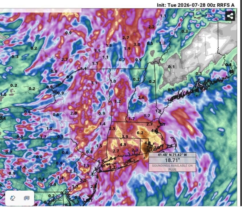
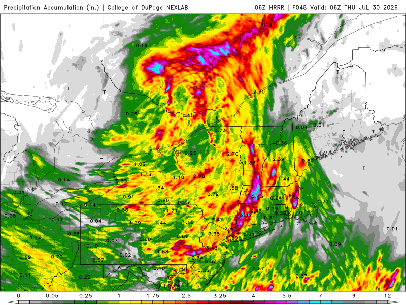
Scott's favorite model does this (00z RRFS)!!! Aug 1955 Diane totals! But the 06z HRRR has almost 7" for Weymouth!
-
00z HRRR was good for big storm coverage in the DC Metro. 06z has backed off somewhat. 00z was putting it all in one big hit 3-7pm. 06z has sct storms in the area around 5pm, then good coverage e-cntrl and sern VA, then a second decent area coming from the PA border spreading SE 8pm-midnight. 00Z RRFS crushes DC metro at 5pm. 06z was a little less impressive but still solid. It does have the best storms in the RIC area. The MCS that moves from OH overnight to WV and wrn VA by noon appears to weaken enough and far enough away, so by peak heating, we should be ok in the much of the DMV. The best winds at 500 and 250 are S of the DC Metro, so I see why 5% tor risk is in sern VA. The NAM has excellent 925 and 850 winds in the DC Metro w/ nice curved hodographs, but the RRFS is less impressive and the GFS/ECWMF as well. Again, best winds fields are S and SE closer to the NC border.
- 2,604 replies
-
- 3
-

-

-
- severe
- thunderstorms
- (and 7 more)
-
In SPC's defense, they did have 2% tor risk for the area, and there was only one tor in WI. And at an atypical time of day, before noon CDT! Intense tornadoes in the morning are rather uncommon. It was not synoptically-evident event, but you do not need that for a significant tornado to occur. Sometimes it all works out on a very local scale. Storms deviate more to the right, ride along a warm front/boundary, storm mergers, etc. that can quickly escalate the situation and give you a high-end tornado event. Case in point - 5/25/2016 ern KS. Large area of sight risk and 2% tor area. A long-tracked EF4 occurred at Chapman KS. It is the #1 tornado chase for many chasers who were on it due to its slow movement, visibility, and structure. It avoided populated areas and no fatalities or injures, so it did not get much attention. That supercell that produced it was it for the state that day. See here: https://www.weather.gov/top/longtracktornadohitsnorthcentralks Plainfield IL in Aug 1990 and Jarrell TX in May 1997 are two other classic examples. 8/24/2016, 22 tors in IN/OH in a small cluster, and quite a surprise! https://www.spc.noaa.gov/climo/reports/160824_rpts.html And then we have 6/5/2024 here, 2% tor risk, and we ended up w/ 13 tors! That caught many by surprise. Warm fronts can be sneaky! Isolated intense tornadoes or local outbreaks can occur at times when it does not look impressive overall synoptically or even on the mesoscale hours before the event. It is not common, but law of averages and large numbers guarantees this will happen every so often.
-
I appreciate you input and response! My point is that 102 there is not the same as 102 in New England b/c the mean temps in the summer are significantly higher in this part of the county, so they are more used to 100 deg temps, so not as impactful net-net. It all relative to the normal climate. 102 in MLS is like 95 in BOS (dry bulb temp). Also, when they hit 102 on 7/26, dew points were in the mid 30s, so that gave a max heat index of 96, so that's a lot closer to their avg high, and this from a human impact standpoint, is that not better? But the media ignores this. Heat index is only mentioned when it is higher than the air temp. MLS POR is 1937 to present, at least for continuous records for monthly averages, so that removes a significant part of the very hot 1930s as to reference the hottest Julys, so although it has hot periods in recent decades, it is not likely as impressive as it seems given the POR. Yes it is still hot, but we need to adjust for climate of the location and the dew points present. It needs to be scaled. Again, going back to the E Coast media bias, they do not take this into account when reporting. They think 90 is "hot" everywhere. I've seen before, "oh it was so hot in DFW today w/ high of 95!", and their normal high in July is 97. See the problem here? The have no context or perspective. Facts are meaningless w/o context. To them it is all just one "furnace" that will end things.
-
Ahh, the warm front! Your lawn will thank you! LOL.
-
That a good point. Actually I just looked, and ydy MLS avg high is 91. 102 is wicked hot for us in New England, but when the avg high temp in July is 6-9 F cooler 91 that in places like BOS/PVD/BDL, it is not so hot to residents in Miles City. The notion that 90 is some kind of benchmark for hot wx is misguided, but try telling that to the MSM. Once again, the E Coast bias, more specifically DCA-BOS, applies here, as if that is typical climate! You often hear X percentage of the CONUS or states AOA 90 on any summer day, acting like that is universally unusual. No it isn't when about 40% of the country has an avg high 90 or higher! Geez, 90 in PHX or LAS in the summer is a *cool* day for them! I was told one time the way to calculate hot, or unusually warm, is take the avg high for the location for a given day, and go 2 standard deviations above that. But I am not sure if you can apply that in all seasons, since big temp swings and deviations are much more common in the winter than summer and the closer to the polar regions you get, the bigger the swings overall.
-
CoastalWx gonna pull out his warm front QPF fcst rule of thumb?
-
Pfftt! "Not unlike the blizzard in Feb" as if you can synoptically compare the two? What a bunch of crap! "Ooo, the track is similar!" -- so? That is meaningless by itself. It reminds me of the "Sandy obsession" that occurred for a few years after Sandy occurred. Some national media would put up every hurricane threatening the E Coast "track similar to Sandy." Stupid,. Using a recent high-end event for more hype. Think about so many in NYC and NJ after Sandy and the trauma that occurred from the record storm surge. That's non-trivial stress brought up from ppl just hearing that passively!
-
Some locations in SE MA/RI/CT are going to end up w. their wettest July on record. And NNE finally gets some as well!
-
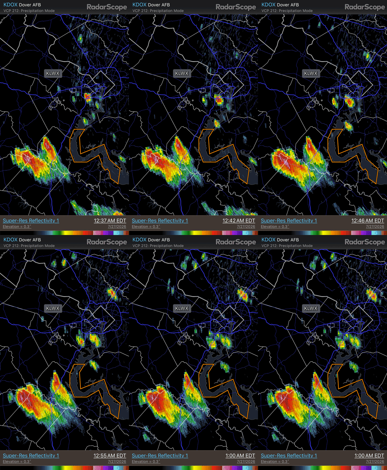
Some overnight action in NW flow. Supercell split here w/ the right most one an anticyclonic supercell (nice flared and sheared appearance) A left split, even though it does not look like that for movement, but you have to remember the frame of reference. In NW flow you have to rotate your frame reference 90 deg from typical SW flow. As is commonl, the anticyclonic storm moves faster than its cyclonic counterpart. Hail cores aloft (loop is from DOX).
- 2,604 replies
-
- 4
-
-
- severe
- thunderstorms
- (and 7 more)
-
Also, a fairly new type of CAPE, ECAPE! It accounts for dry air entraiment. "Substantial mixing occurs between the upward-moving air currents in thunderstorms (updrafts) and the surrounding comparatively dry environmental air, through a process called entrainment. Entrainment controls thunderstorm intensity via its diluting effect on the buoyancy of air within updrafts." CAPE values we see plotted are almost never full realized due to dry air entrainment. How much entrainment occurs varies greatly. https://journals.ametsoc.org/view/journals/mwre/147/3/mwr-d-18-0137.1.xml AMS24poster.pdf
- 2,604 replies
-
- 1
-
-
- severe
- thunderstorms
- (and 7 more)
-
Yet another solid 500 trough for July, This time actuality cuts-off and is slow to move out, so looks like Mon-Wed tstms each day in some form, and maybe Thu if the ECMWF is right. Tue appears the best for svr wx currently. GFS and ECMWF don't hesitate to replace this 500 low w/ another one just beyond week, so active times ahead it seems.
- 2,604 replies
-
- 3
-
-
- severe
- thunderstorms
- (and 7 more)
-
Yes, I thought of the terms used for CAPE here, but that's what is in literature. Maybe "wide" and "narrow" CAPE is better!
-
Yes, I agree. 30-yr does have practical uses, but for long-term climate, and I am talking on geological scales, it is useless. Things exist in a rather large range from a local to global scale when you consider how long the Earth has been around, and that's ok. Geez, the range of things from a climatic POV over millions of years? Also, I have seen things done w/ 30-year normals, both on a deliberate and accidental level. Using some random 30-year period to scale wx and records in the present. Which 30-year normal baseline is best to quantify changes or trends to the present? You see one can pick and chose to get desired results here either way. And why 30 years? Is this something significant climate-wise about 30 years? Given that is a tiny speck geologically, I would say not. It sounds more like a human convenient period (generational?) than anything else! We have a tendency to scale and build things around what humans consider a "long-time," but that does not work on geological scales. And then you run into period of record varying greatly for many locations across the globe, so there is big challenge here. We have to have something for a baseline, but having something does not mean it works well for all things.
-
And leave out conditions have improved in the last week in SNE. And in the large pix, I find it hard to believe that srn RI and SE MA are still svr drought conditions given the 8-11" of rain in the past 3 weeks (the way the drought conditions are calculated I have long have issues w/ despite how it isn't just about rainfall). Although the cut off day of 7/21 at 8am missed the big rains the following 24 hr, the post could have said how it has improved just in the last 48 hr which the map did not account for. Omission of facts to promote a particular narrative or prevent deflating hype! And really, how much of daily routine life has been impacted for the general public b/c we have had drought conditions for awhile? Yes, there are some impacts but nothing that we can't handle/absorb and have done so for a very long time. The way the MSM pushes drought often you'd think it is debilitating issue and our water supply is running out!
-
As if what happened last August has *any* relevance or influence on what this August will be like? Useless filler statement in the context of forecasting. This would be like saying, "recall last winter CoastalWx has two 20"+ snowstorms in Weymouth..." for this upcoming winter fcst. And not to leave out Wxwiz, for July 10 any year that has a tor risk on this day, "recall on July 10, 1989 we had 17 tors in the NEUS for its biggest outbreak on record!"
-
Enter August 2, 1975!