vortex95
-
Posts
2,211 -
Joined
Content Type
Profiles
Blogs
Forums
American Weather
Media Demo
Store
Gallery
Everything posted by vortex95
-
WxWiz, I used to have a nickname for CoastalWx - EML MAN! I think I will give the name to you now!
-
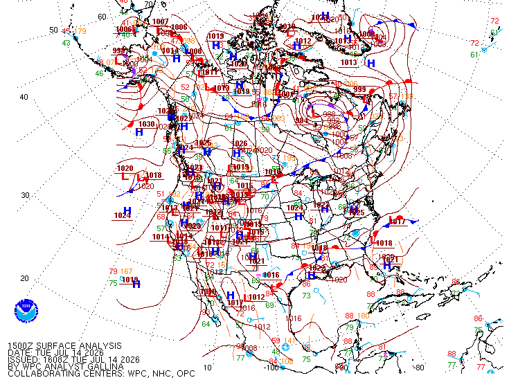
Odd mesoscale feature that cloud line. Something you more typically see in the Plains where anything is possible convective-wise! WPC shows no warm front anywhere but there has to be something there looking at the thickness packing alone across srn Quebec to ern ME.
-
Was this the storm that had a crazy narrow solid line of CGs that spanned almost all of MA WSW to ENE?
-
Not 10% in ME though, right?
-
I do not think so, at least for ME, but 10% tor as an area SPC uses did not exist prior to the mid 2010s (correction, saw the other post for the 2010 10% in SNE, so when SPC started using probs? - 2000?), just like ENH and MRGL did not. I think the tor probs used to go 2, 5, 15, etc. Yet you get these hype-masters going, "first time ev-A 10% tor prob in ME!" (same for ENH). Well, yes, but you are leaving out the short history here. Omitting key details that would otherwise deflate their hype. That being said, I do not recall any svr day w/ such a high risk for supercell/tors for NW ME. In fact, I do not think there has been a F3/EF3+ tor in ME/NH/VT, at least using the SPC database that goes back to 1950. Using the Tornado Project, only F3/EF3+ for NNE is the Sep 1821 cntrl NH tor. However, given the sparse population of NNE, esp. NW ME, sig tors, along w/ many weak tors, have unquestionably been missed.
-
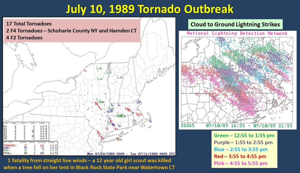
Incredible LTG show incoming tonight! EML FTW! 7/1 was good in that you have CONS flickering LTGIC esp. in the mid and upper part of the CBs, but CG and CC LTG overall was about avg. This situation is more potent, so the LTG should be high-end for all types! The tornadic HP monster that tracked from W of ALB to LI on July 10, 1989 had 12,500 CGs in it first 5 hr of existence. Here is a CG plot from that day (WxWiz - "I will treasure this image FOREVER!:).
-
When the dynamics/forcing are strong and an EML present, diurnal heating is less important. Not that it does not matter at all, it does, esp. for sig tor, but I will tell you, on July 10, 1989, after the AM tstms w/ the warm front in region, it remained mostly cloudy (thick high OVC) over much of the region, and this did not impede things at all w/ 3 discrete supercells -- SE NH, central MA (CoastalWx got it in Brockton eventually!), and the monster HP that tracked from W of ALB to LI (WxWiz's dream storm!!!). BDL was something 68/66 when the warm front passed July 10, 1989, and a few hours later 86/74, this was w/ lots of clouds present. Strong WA and moisture advection overcame the lack of insolation.
-
Understood. Social media has it challenges as to what ppl mean and imply.
-
97 not hot enough for Scott? "I WANT 100! IF NOT, FAIL!"
-
Time of day does matter if you want to realize the max sfc temp for the day using 850. Reaching 27 C after peak heating is not the same for sfc temp as already being 27 C in the morning and the mixing out fully for peak heating.
-
Well if the 27 C at 850 does not arrive until 6pm?
-
Updated from WFO GYX!
-
Since the WAA is continuous through the day and not in place for the start, the absolute max potential for temp is not realized, much to CoastalWx's dismay. BTW, we don't live at 850.
-
My favorite was one of the shows when they combined Nostradamus w/ the Mayan calendar 2012. Stupid! Speaking of Nostradamus, this shows that media fear-mongering is nothing new. This scared me as a kid! https://en.wikipedia.org/wiki/The_Man_Who_Saw_Tomorrow
-
Yes, going by ACE, if you use the current 123 seasonal ACE normal value. All New England landfalling hurricanes since 1938 have been below avg ACE years, except 1969.
-
Not that many sig tor (F2/EF2+) in NNE on record. Attached is a list of the farthest N ones. Any tor documented close to the Canadian border outside the CAR area are rare. Only one since 1975 I could find is this one. ME MAY 23, 1984 1620 0k 0inj 15y 0.3m F1 SOMERSET - Homes were damaged and a barn lifted and thrown in Jackman.
-
I like what I see. Typically, set ups this potent in New England only occur every 10-15 years or so, going by our most sig tor events/outbreaks. This qualifies as one IMHO, and it has been 15 years since 6/1/11. Large-scale, this is not simply NW flow ring of fire event like we had on 7/1. There is a very strong 500 low over central Quebec w/ a center that gets as low as 543 dm, which is quite impressive for July. This is *true* NW flow, the best kind for the big svr here. EML solid up to 8 C/km. Timing looks absolute best for srn Quebec, but NNE should do very well. Noted CAPE fcst as high as 4100 on HRRR near YUL Tue aftn and 0-6km shear is more than enough for mean supercells. It is not as high as it was on 6/18, but we were severely lacking in CAPE and there was no EML, so things are more than compensated here for meaty storms and "Scott spinners." A few things of note that remind me of 7/10/1989. 1) Very strong WAA prior to the event, Look at the 12z NAM 1000-500 thk 14/12z to 15/00z for BOS, it jumps from 574 to 584! 2) I attached the 12z NAM valid 15/00z. Look at the orientation of the very high thk, a W-E axis. This is exactly how it looked on 7/10/1989, except the axis was about 100 mi farther S. For that event, it was capped from just S of NYC and S. So where SPC has the sharp cut off of storms in central New England makes sense 100%. If I had to find a negative, the 925 mb winds and 0-1 km shear could be higher, at least during the daylight hours, but by 00z, it is more than enough low-level shear for spinners. However, diurnal stabilization of the BL may limit solid spinners potential in New England. But the 18z HRRR is still showing small areas over 200 0-3 km CAPE 00/01z across far NNE, which is more than enough for solid low-level stretching and thus spinners. Historically, it is very rare for New England to get sig tor after dark (F2/EF2+). One thing that is almost certain, unreal LTG shows coming for ME/NH/VT Tue evening/overnight. better than event on 7/1. EMLs "like" to do that! The fact SPC has a hatched area for tors is not that common in New England, *and* wind/hail are also hatched for the full gamut of a big svr event! Updraft helicity swaths are nasty on the HRRR, again, rare to be this intense here. SCP and SIGTOR parameters are about as high as you will ever see them in the NEUS. Interesting the storms at first look more linear during the day on the HRRR, but become somewhat more discrete by sunset. This is likely due to the improving shear profiles at low-levels, so tor risk appears good at this later time. Really not much more to say. Slicing and dicing the models down at this point is not that much use. This is a high-end set up. Everything is there for a big event. Intense tstms are a virtual guarantee, just the question is the extent of the spinners overall in srn Quebec and NNE.
-
Summaries I made using data from The Tornado Project.
-
Yes, every location/region "pays the piper" eventually. Just it varies for each wx phenomena and climo! I don't think the general public understands this, and since some events are so uncommon and exceed regular memory or lifetimes, ppl freak easily. I get it, experience matters, but that's where knowing and understanding wx history comes in. I can not emphasize that enough! The point I was trying to drive home overall is that a min Cat 1 landfall, which is *not* extreme or unusual in the large pix for New England, will be treated as extreme b/c *impact* will be enormous. What I see all too often these days is that ppl conflate a wx event intensity w/ impact. They are not always directly correlated. Biggest SNE case I quote a lot is Dec 13, 2007 4-8" traffic nightmare. Run-of-the-mill storm well forecast, just timing was bad, and decisions made by officials/authorities made it epic bad from dismissing everyone from work/school noon-1pm when the S+ was underway. That scale of impact had almost nothing due to w/ the 4-8" of snow itself here. We handle 4-8" easily the vast majority of the time. So the hurricane massive and record power outages will largely be a function or increases population, infrastructure, mismanaged of land (tree trimming, etc), and things like power companies not prepared for the scale of impact (not enough staffing/equipment increase over time to handle the much larger population and infrastructure). And this will happen w/ a min Cat 1 hurricane almost certainly. Sure, you can blame the fact that we have gone record long w/o a landfalling hurricanes here, but the door swings both ways. Would it be better to have more landfalling hurricanes so we avoid the inexperience and complacency???
-
In the Atlantic "quiet" phase 1970-1994, we got 3 landfalling hurricanes here. Since 1995 in the Atlantic "active" phase, nothing so far! But any correlation falls apart when you look at the previous "active" phase 1926-1969. It shows how you have to be careful w/ forecasting from cycles and analogs. That being said, seasons that have more "home-grown" TCs do increase risk to the East Coast by virtue of you don't have systems forming way out at Cabo Verde where they are vulnerable to recurvature due to just a huge distance to cross. Also, waves or weak systems that never develop in the deep tropics/MDR have a better chance of making it all the way across since they are more governed by the low-level easterlies. Then they "make their move" outside the deep tropics closer to the East Coast. Carol and Bob are two excellent examples of home-grown big hits here.
-
I'm not scared, just I realize the enormity of the situation. I don't think many do, so I am going to throttle it in this case. You seem to forget I live the DC area now, and I definitely "don't* want to be there when it happens. As much as I loved Gloria and want to see that again, I realize that times have changed and I can dismiss weenie-ism for practical purposes. Maybe you can do the same for snow? Right! I know that's a hopeless case b/c you still complained after getting two 20"+ event in this past winter in Weymouth!
-
People get all excited when these see a deep trough along 80W or so and a hurricane approaching the Bahamas. However, the ridge of high pressure to the NE is what is all about in the end. If you do not have that, forget it! From empirical observations alone, give a hurricane *any* excuse to recurve sharper than any model fcst once N of 35N, it will, unless you have that block to the NE. I don't care how strong the trough is or how negative it gets, you need the high to prevent "escape."
-
CoastalWx needs to test his "120 mph wind risk zoning" in Weymouth! Don't get him started on that when he moved there!
-
Perspective matters! Too many that have never lived anywhere else in one location often have this skewed perception about wx in general. The "IMBY Syndrome" I like to call it. Also, we have this bias in a regional sense in this country, as in "East Coast is i!t" More specifically DCA-BOS and sometimes the "center of the universe" NYC! Wx does not care about where we chose to populate the most, but our cognitive biases tell us otherwise!
-
Can you imagine 75% of customers w/o power in MA/CT/RI alone? That's what would likely happen w/ another 1938. Sandy at max had about 8M ppl w/o power I think, but that was spread from BOS to DCA. How about 8M in SNE alone? That's *way* worse. New England direct hurricane strikes being rare have a big plus, but also big minus. The minus being the population has limited or no experience w/ them so when one finally occurs again, it is a *lot* worse, esp. psychologically, and almost 35 years now since the last? A disaster is often only as bad as the preparation, or lack of it. The Gulf Coast and and FL know the deal being through it so often, and they are much better prepared each time b/c of this. The downside of course is that the get hit more. Well, everything has a cost/benefit ratio, but there is nothing inherently "wrong" w/ that! In this case, it's just climo! And of course when this New England hurricane disaster finally occurs again, they will blame climate change. Ignore facts and history b/c the "cause" is all that matters. So when we had 5 landfalls 1938 to 1960, was it climate change then? Worst SNE flooding on record also in this period (Connie/Diane Aug 1955). Why is it almost 35 years now w/ no landfall, which is the record (or second place depending on what you count), when the globe got steadily warmer during this time? How can this be? How do you resolve this contradiction to the narrative? Everything is supposed to get worse across the board! This is a problem mindset now, linear and vapid thinking, Bandwagon fallacy and let emotions rule rather than logic and reason. Cherry-pick information to maximize the narrative. Logical fallacies and cognitive bias are *rife* here, and these shortcomings of human nature exploited by TPTB. Not saying climate change is not a problem, it is (you have to say this b/c otherwise you get "DENIER!"), but they way it is handled is all messed up due political/social/economic factors, among other things. The science is contaminated. This I think we all can agree on! When you talk about anything, esp. a problem, you need to include *all* information. The narrative for climate change is distinctly lopsided (the world is going to end). and it goes beyond just a particular narrative, it also is highly negative, and negative news sells, plain and simple. So independent of any politics, the *business* for climate change is huge, and is exploited for profit. There is unsaid mode for those in power, "never let a problem, disaster, or tragedy go to waste!"