vortex95
-
Posts
1,488 -
Joined
Content Type
Profiles
Blogs
Forums
American Weather
Media Demo
Store
Gallery
Everything posted by vortex95
-
WxWiz will do his best to apply "english" to the risk areas to nudge them closer to CT!
-
The watch now would not be for the big stuff later I think. Marginal svr is psbl this aftn in cntrl/nrn ME. The tor box would be later for far nrn VT/NH, and NW ME.
-
Dual pol makes it easier w/ the TDS. It really narrows things down and gives confidence, so the NWS may be more inclined to send a survey to the area(s) despite the remote location, And now we have drones to scout out areas that are not accessible by road/foot. And I think at times if a strong TDS is present in a very remote area, the NWS will count that as a tor even if no survey or ground reports.
-
Stranger things have happened! How about this from July 1987? I think I will be a 2.5 mi wide F4 and cross the Continental Divide! https://www.tornadotalk.com/teton-wilderness-wy-tornado-july-21-1987/
-
Wait, no or yes? This is the first time for a ME 10% tor risk you mean?
-
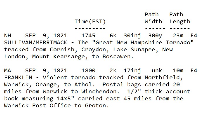
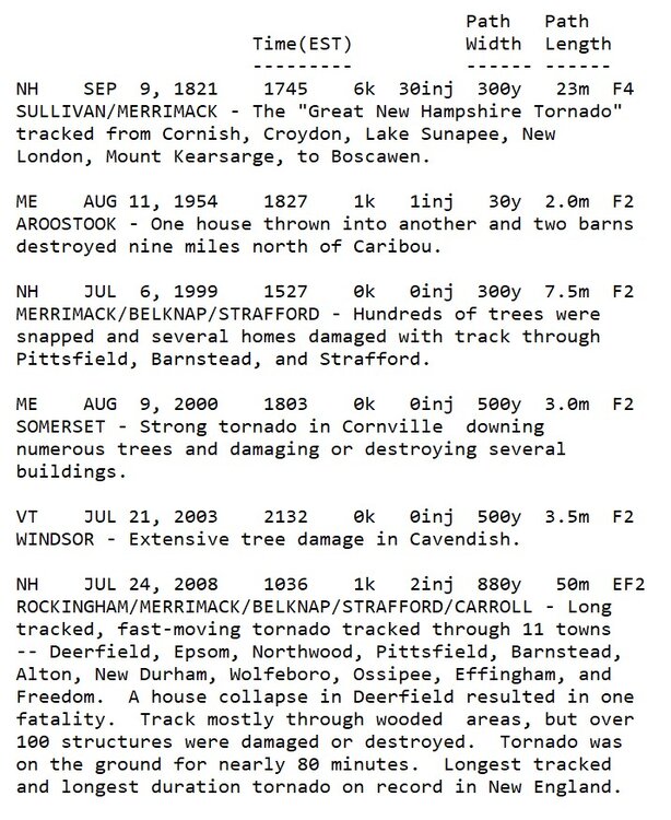
Neither has VT. NH only one is the Sep 1821 event.
-
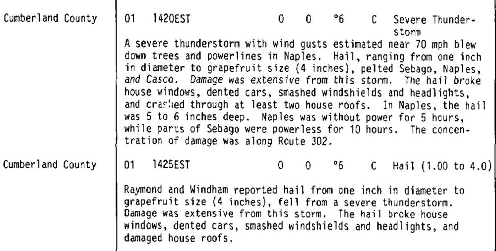
For reference, the biggest hail in New England is 4" in SW ME on 6/1/1986. Here is the Storm Data entry.
-
WxWiz, I used to have a nickname for CoastalWx - EML MAN! I think I will give the name to you now!
-
Odd mesoscale feature that cloud line. Something you more typically see in the Plains where anything is possible convective-wise! WPC shows no warm front anywhere but there has to be something there looking at the thickness packing alone across srn Quebec to ern ME.
-
Was this the storm that had a crazy narrow solid line of CGs that spanned almost all of MA WSW to ENE?
-
Not 10% in ME though, right?
-
I do not think so, at least for ME, but 10% tor as an area SPC uses did not exist prior to the mid 2010s (correction, saw the other post for the 2010 10% in SNE, so when SPC started using probs? - 2000?), just like ENH and MRGL did not. I think the tor probs used to go 2, 5, 15, etc. Yet you get these hype-masters going, "first time ev-A 10% tor prob in ME!" (same for ENH). Well, yes, but you are leaving out the short history here. Omitting key details that would otherwise deflate their hype. That being said, I do not recall any svr day w/ such a high risk for supercell/tors for NW ME. In fact, I do not think there has been a F3/EF3+ tor in ME/NH/VT, at least using the SPC database that goes back to 1950. Using the Tornado Project, only F3/EF3+ for NNE is the Sep 1821 cntrl NH tor. However, given the sparse population of NNE, esp. NW ME, sig tors, along w/ many weak tors, have unquestionably been missed.
-
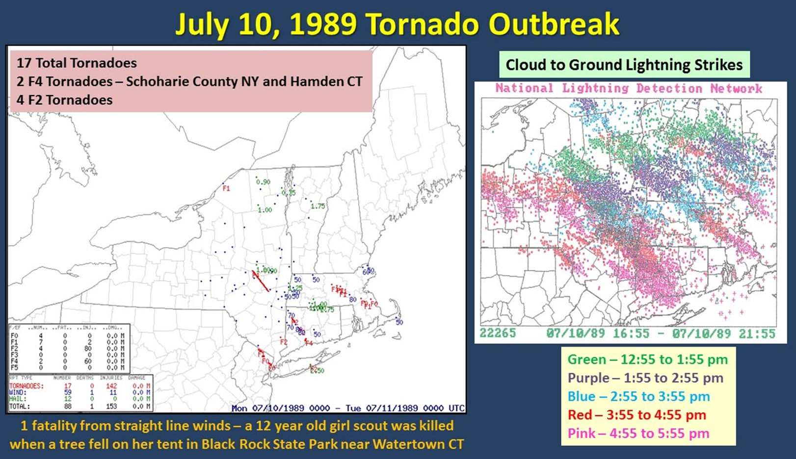
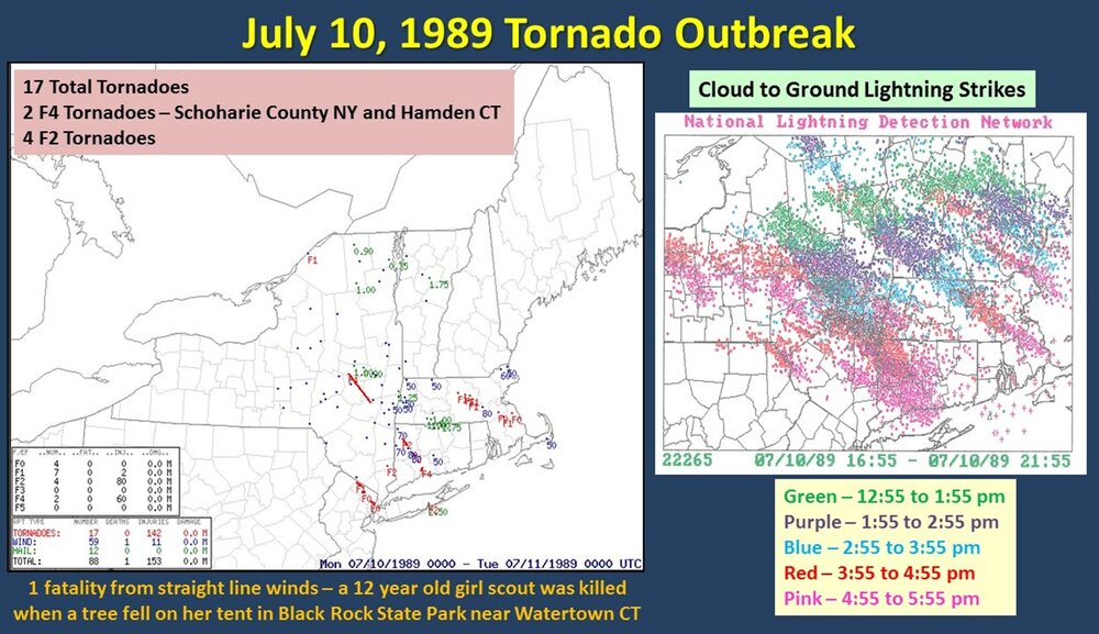
Incredible LTG show incoming tonight! EML FTW! 7/1 was good in that you have CONS flickering LTGIC esp. in the mid and upper part of the CBs, but CG and CC LTG overall was about avg. This situation is more potent, so the LTG should be high-end for all types! The tornadic HP monster that tracked from W of ALB to LI on July 10, 1989 had 12,500 CGs in it first 5 hr of existence. Here is a CG plot from that day (WxWiz - "I will treasure this image FOREVER!:).
-
When the dynamics/forcing are strong and an EML present, diurnal heating is less important. Not that it does not matter at all, it does, esp. for sig tor, but I will tell you, on July 10, 1989, after the AM tstms w/ the warm front in region, it remained mostly cloudy (thick high OVC) over much of the region, and this did not impede things at all w/ 3 discrete supercells -- SE NH, central MA (CoastalWx got it in Brockton eventually!), and the monster HP that tracked from W of ALB to LI (WxWiz's dream storm!!!). BDL was something 68/66 when the warm front passed July 10, 1989, and a few hours later 86/74, this was w/ lots of clouds present. Strong WA and moisture advection overcame the lack of insolation.
-
Understood. Social media has it challenges as to what ppl mean and imply.
-
97 not hot enough for Scott? "I WANT 100! IF NOT, FAIL!"
-
Time of day does matter if you want to realize the max sfc temp for the day using 850. Reaching 27 C after peak heating is not the same for sfc temp as already being 27 C in the morning and the mixing out fully for peak heating.
-
Well if the 27 C at 850 does not arrive until 6pm?
-
Updated from WFO GYX!
-
Since the WAA is continuous through the day and not in place for the start, the absolute max potential for temp is not realized, much to CoastalWx's dismay. BTW, we don't live at 850.
-
My favorite was one of the shows when they combined Nostradamus w/ the Mayan calendar 2012. Stupid! Speaking of Nostradamus, this shows that media fear-mongering is nothing new. This scared me as a kid! https://en.wikipedia.org/wiki/The_Man_Who_Saw_Tomorrow
-
Yes, going by ACE, if you use the current 123 seasonal ACE normal value. All New England landfalling hurricanes since 1938 have been below avg ACE years, except 1969.
-
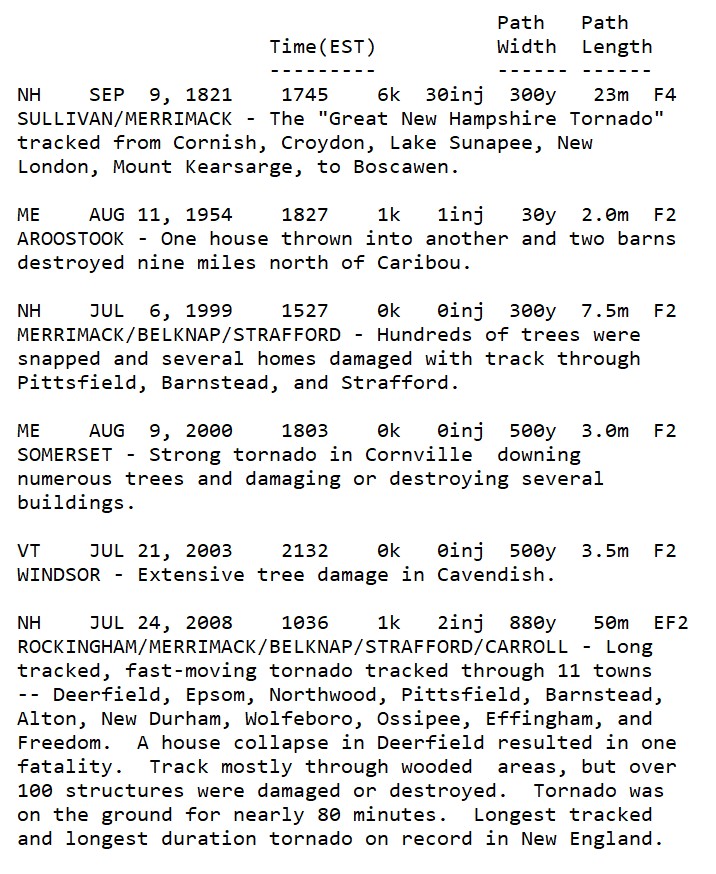
Not that many sig tor (F2/EF2+) in NNE on record. Attached is a list of the farthest N ones. Any tor documented close to the Canadian border outside the CAR area are rare. Only one since 1975 I could find is this one. ME MAY 23, 1984 1620 0k 0inj 15y 0.3m F1 SOMERSET - Homes were damaged and a barn lifted and thrown in Jackman.
-
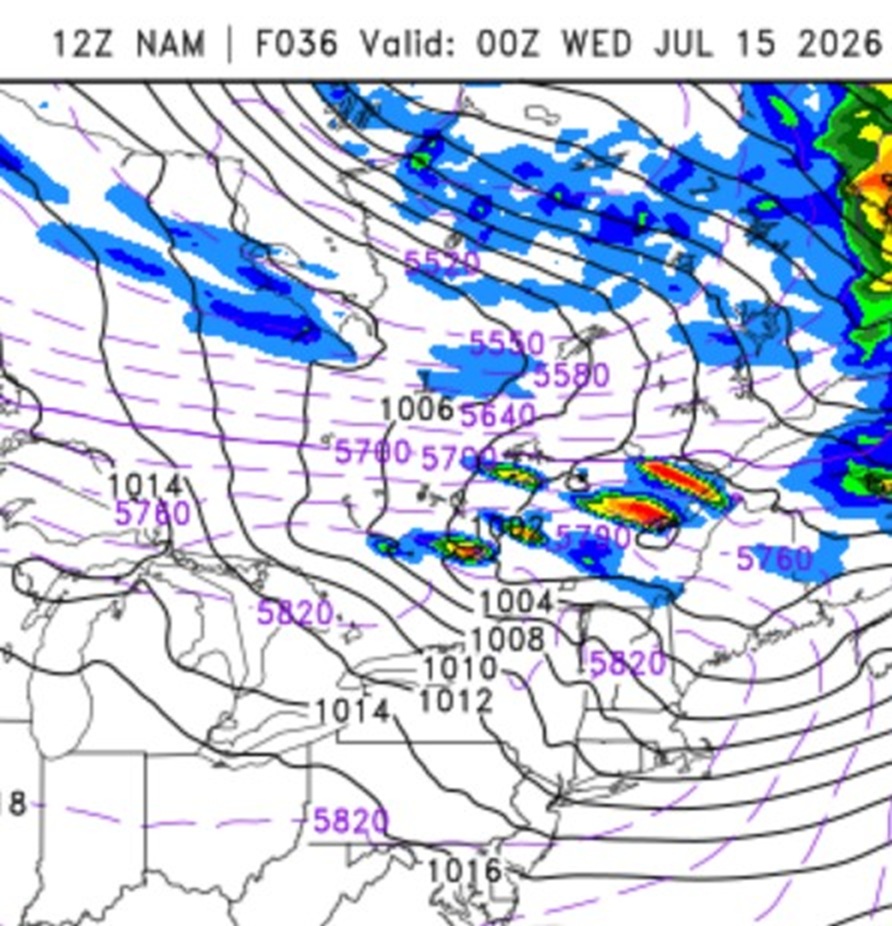
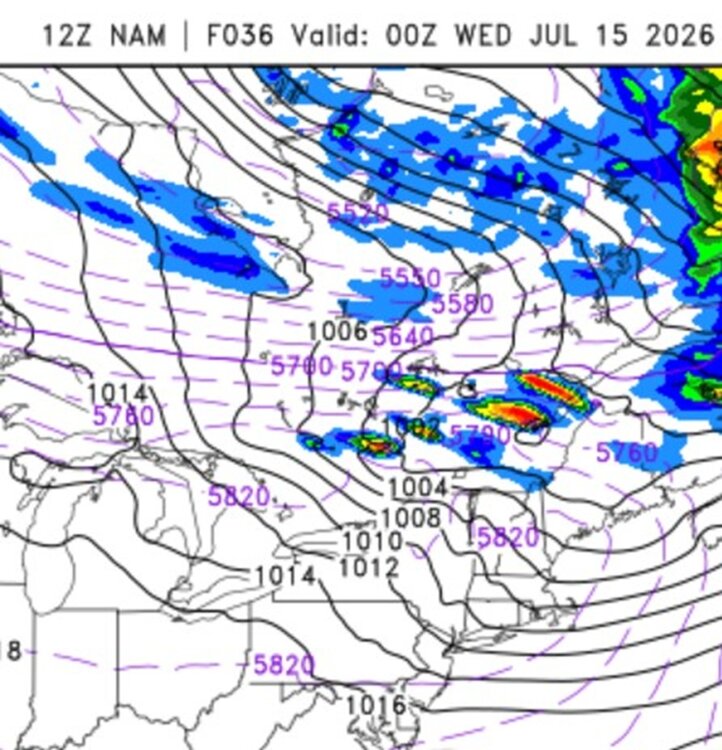
I like what I see. Typically, set ups this potent in New England only occur every 10-15 years or so, going by our most sig tor events/outbreaks. This qualifies as one IMHO, and it has been 15 years since 6/1/11. Large-scale, this is not simply NW flow ring of fire event like we had on 7/1. There is a very strong 500 low over central Quebec w/ a center that gets as low as 543 dm, which is quite impressive for July. This is *true* NW flow, the best kind for the big svr here. EML solid up to 8 C/km. Timing looks absolute best for srn Quebec, but NNE should do very well. Noted CAPE fcst as high as 4100 on HRRR near YUL Tue aftn and 0-6km shear is more than enough for mean supercells. It is not as high as it was on 6/18, but we were severely lacking in CAPE and there was no EML, so things are more than compensated here for meaty storms and "Scott spinners." A few things of note that remind me of 7/10/1989. 1) Very strong WAA prior to the event, Look at the 12z NAM 1000-500 thk 14/12z to 15/00z for BOS, it jumps from 574 to 584! 2) I attached the 12z NAM valid 15/00z. Look at the orientation of the very high thk, a W-E axis. This is exactly how it looked on 7/10/1989, except the axis was about 100 mi farther S. For that event, it was capped from just S of NYC and S. So where SPC has the sharp cut off of storms in central New England makes sense 100%. If I had to find a negative, the 925 mb winds and 0-1 km shear could be higher, at least during the daylight hours, but by 00z, it is more than enough low-level shear for spinners. However, diurnal stabilization of the BL may limit solid spinners potential in New England. But the 18z HRRR is still showing small areas over 200 0-3 km CAPE 00/01z across far NNE, which is more than enough for solid low-level stretching and thus spinners. Historically, it is very rare for New England to get sig tor after dark (F2/EF2+). One thing that is almost certain, unreal LTG shows coming for ME/NH/VT Tue evening/overnight. better than event on 7/1. EMLs "like" to do that! The fact SPC has a hatched area for tors is not that common in New England, *and* wind/hail are also hatched for the full gamut of a big svr event! Updraft helicity swaths are nasty on the HRRR, again, rare to be this intense here. SCP and SIGTOR parameters are about as high as you will ever see them in the NEUS. Interesting the storms at first look more linear during the day on the HRRR, but become somewhat more discrete by sunset. This is likely due to the improving shear profiles at low-levels, so tor risk appears good at this later time. Really not much more to say. Slicing and dicing the models down at this point is not that much use. This is a high-end set up. Everything is there for a big event. Intense tstms are a virtual guarantee, just the question is the extent of the spinners overall in srn Quebec and NNE.
-
Summaries I made using data from The Tornado Project.