vortex95
-
Posts
1,488 -
Joined
Content Type
Profiles
Blogs
Forums
American Weather
Media Demo
Store
Gallery
Everything posted by vortex95
-
This falls along the lines of how TCs are treated N of 35N. You can't apply conventional TC rules at higher latitudes due to ET transition and a host of other factors. I think this was w/ Earl in 2010. All models had the hurricane passing E Cape Cod w/ its recurvature. Yet they had TS warning as far W as BDR? That is ridiculous. That explicitly says TS sustained (not gusts) are forecast. How are you going to do that w/ a system that passes E of Cape Cod? TCs are no longer symmetrical at this latitude due to ET transition, and due to forward acceleration, the winds are greatly mitigated W of the center track. It's not "one size fits all" for wx events and all locations, but that's the impression I get at times.
-
I agree.
-
I try to kindly to back off and end it humbly, and you continue w/ a non-sequitur argument. One does not have to actual live in any given area to know and understand its climate, and all its local nuances and changes over time. Can we be more civil and respectful here?
-
I am not lost. I explained myself in the previous post. Crossovers are going to occur at times and threads start to go off on a tangent. That's social media for you. I get it, and I will refrain and be more careful going forward. Levity and implied disparaging statements are not necessary. This is not a contest or right/wrong match. I've been in DC for 8 years now, so I am hardly "new" to this area, just I am participating more on AmrWx now. I have been on AmrWx for over 20 tears.
-
Understood. Not trying to cause issues. So many topics in wx are inexorably tied together, it's not always easy to parse things out neatly. And sometimes discrete topics discussed together are relevant and provide value. Yes, I know that is subjective, but that's par for the course.
-
Not at all. Not implying anything in this case. I am big into wx reporting stations around the globe and keep track of all METAR/TAF/SYNOP/BUOY.
-
Thanks for posting the graph! You can see the big years clearly. 1980, 1988, and 2012 show up well. I agree the long-term trend is up, but it's not strongly. IMHO, the biggest factor is the UHI. I'm originally from the BOS area. Logan Airport has a bunch of issues w/ temp, precip, and snowfall. For temp, once the airport was built, the obs were moved from the downtown. Through the late 70s, the wx equipment was next to the building that housed the NWS at the airport. Then the wx equipment was moved to the center of the runways. Makes sense from an aviation standpoint. But this actually made things *cooler* in the summer b/c the runways are surrounded by water on 3 sides (landfill). So BOS hit 102 on July 21, 1977, and then did not hit 100 again until July 14, 1995. It hit 100 many, many times before 1977. It took 18 years for the UHI effect to get BOS to 100 again, and it has no problem hitting that since. Just shows how even minor changes to wx equipment location can make a sig difference!
-
I seem to recall a few sites got the ceilometer upgrade going back several years, but I haven't heard much since. AWOS-4 does not mention it has this upgrade.
-
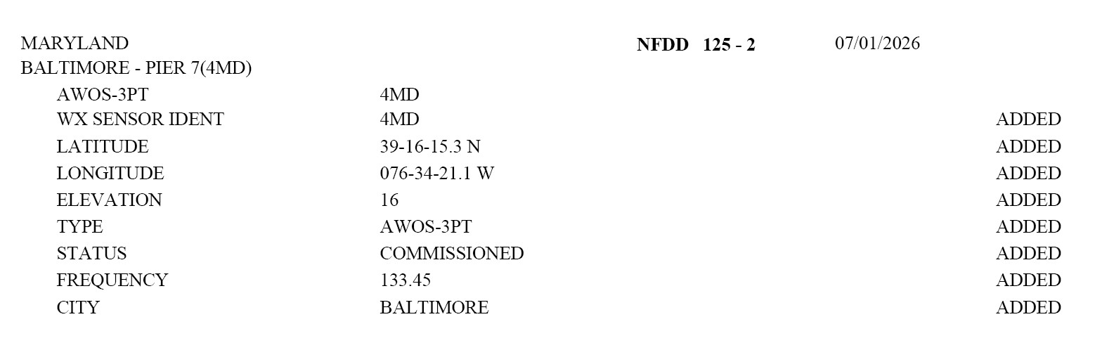
And I just came across this. An AWOS was just commissioned at the Pier 7 Heliport in Baltimore. https://www.airnav.com/airport/4MD So a site to compete w/ the furnace that KDMH is? LOL. The site METARs are not on the WMSCR/NCEP feeds currently. Not sure if they will be, but if they are added, I will let the forum know. No AWOS phone number was listed in the NFDD entry (see attachment).

-
And I will post this again for reference. Go figure! Washington DC ended a streak of 2867 days w/o 100 F reading on 6/22/2024. This is the 5th longest period on record since 1872.
-
DOV is indeed an ASOS (DoD run). BLM is a Federal AWOS, AO2 shows up both on ASOS and AWOS. Most AWOS are privately-owned, but that does not seem to change the equipment/sensor issues whether is Federal or private. One way you can tell a non-Federal from Federal AWOS or ASOS is the SLP group. if it is missing, that's a non-Federal AWOS. About 10 years ago. all Federal AWOS got upgraded so they basically report just like ASOS. First Federal AWOS were installed in 1989 (KILE, KPWT, and KFOD were the first I think). I attached a list of all Federal AWOS. federalawos.txt
-
Wow, CT today sure over-performed. 3 discrete cells (one a supecell) lined up across the state, and then a honkin' SQLN sweeps through! So who on this forum in CT got 4 separate thunderstorms today? WxWiz????
-
580 thickness? 60,000 ft I bet occurred w/ such a high tropopause/EL!
-
That's good you brought up the DP plot for the day. That 81 on the NJ coast... I think that's KBLM? That's an AWOS so that is likely very suspect.
-
I think we can all agree that the hype and gloom/doom everywhere is a problem. Find some common ground on an issue/debate, and work from there. If we do not quantify a problem/issue properly, then how are we supposed to handle/address it properly? Resources and $$ are finite/limited, and we know wasteful spending/graft are rife. You are not going act the best way if you are fired-up and we are fighting among ourselves! Emotional, knee-jerk reactions to problems/issues almost always end up counterproductive. Perhaps not at first, but the long-term, and the long-term is what counts. But it is a challenge for all of us to think more iong-term and in the abstract b/c we want solutions and things fixed now! Shortcoming and fallacies of human nature always are there causing their own problems. But realizing/understanding this as a base, make discussions/debates better IMHO.
-
Yes, I've notice that as well. The higher the DPs, the more error occurs. I looked at the the JFK obs string at that time for the 84 DP. Nothing stood out for any change for wind speed/dir or change in pres. No storms in the vicinity. Now if this was Hatteras and S, I can see DP spike up like this since the SSTs are so high, but not here.
-
It's a legit summer nor'easter. Sfc low not that strong, but the pres gradient N of it is quite good for July. Duration coupled w/ sig higher PWATs than other times of the year, and voila!
-
HRRR suggests it could be more than just those regions. I'm just talking decent tstms, not svr.
-
Thanks for the feedback/input. Climate hype is still rife on social media, and if you look at a lot of MSM news and wx segments, they are still pushing the gloom and doom narrative often. Also, even w/ politics shifted this country, look at a lot of rest of the world and organizations like the UN and WEF. The end of the word narrative from AGW is alive and well still. And going one step further, this is case of "bad news sells," which is apolitical, so that's what drives it a lot. The boogie man changes over time, but it's always there out to get us. In the 70s, it was pollution in general and the ice age coming, in the 80s, it was the ozone layer and acid rain, and by the 90s it switched to climate change and has not looked back. The deniliasm part is merely subset of any problem that exists and is hype or over-promoted. Par for the course. I don't like denialism as a term, as much as I don't like blindly embracing a narrative or ideology. That's a false dichotomy and suggests a lack of critical thinking. As w/ many things, the truth often lies in between. Not exactly 50-50 w/ every issue either, and things are often a lot more complex than they seem w/ no easy answers as well.
-
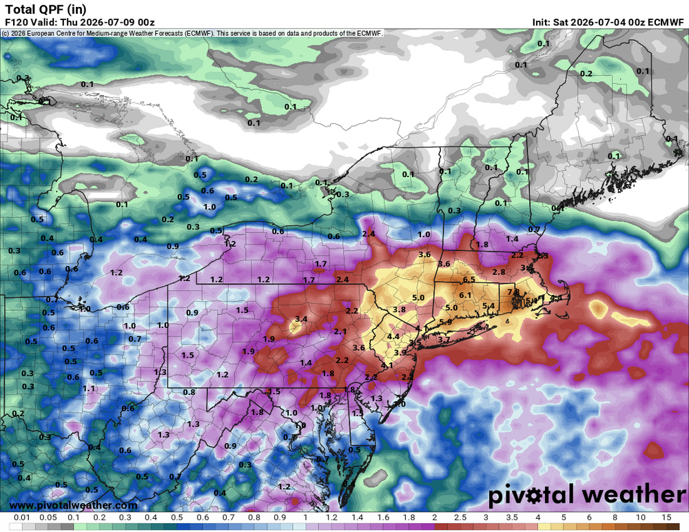
Pivotal shows a max of 7.87". Summer NAW'easter!
-
Looks decent for CT. Latest HRRR suggests a small bowing segment 7-9pm.
-
Scott rain PT.
-
Only Ineedsnow would say MEH to a 140 kt STY! It's the CoastalWx equivalent of saying MEH to 6/1/11.
-
Take a look at this short paper from 2004. Odds are it has been exceeded, and since 2004? Several candidates (Haiyan in Nov 2013 almost certainly). strongerTC.pdf
-
If we only have recon in these monsters. I will tell you given what recons measured from the 1940s to 1987 in the WPAC, if it was done today w/ the much more advanced tech such as GPS dropsondes and the SFMR, you want to talk records and extreme that would put all to shame what we have seen in recons in the ATLC? The few research mission recons we have had over the years in the WPAC have shown incredible stuff. Satellite estimates can only do so much. Dvorak estimates work best for TCs between 60 and 105 kt. This means two things - 1) many TDs are actually weak TSs, and 2) most very intense TCs are underestimated. The inner core of these things are strange beasts, acting more mesoscale than anything when you get to Cat 5 levels. EPAC Patricia in 2015 would have been capped at 160 kt from satellite estimate only, but recon actually found 185 kt winds. As a result of the above, TC intensities and annual ACE globally are underestimated, and the further you go back, esp. prior to the satellite era, the more off it is. And really w/ recon, we only started to see things in proper detail w/ the advent of the GPS dropsonde in the late 1990s and the SFMR in 2004. So you can't really use the database we have over the long-term for true TC trends.