vortex95
-
Posts
1,488 -
Joined
Content Type
Profiles
Blogs
Forums
American Weather
Media Demo
Store
Gallery
Everything posted by vortex95
-
Yes, every location/region "pays the piper" eventually. Just it varies for each wx phenomena and climo! I don't think the general public understands this, and since some events are so uncommon and exceed regular memory or lifetimes, ppl freak easily. I get it, experience matters, but that's where knowing and understanding wx history comes in. I can not emphasize that enough! The point I was trying to drive home overall is that a min Cat 1 landfall, which is *not* extreme or unusual in the large pix for New England, will be treated as extreme b/c *impact* will be enormous. What I see all too often these days is that ppl conflate a wx event intensity w/ impact. They are not always directly correlated. Biggest SNE case I quote a lot is Dec 13, 2007 4-8" traffic nightmare. Run-of-the-mill storm well forecast, just timing was bad, and decisions made by officials/authorities made it epic bad from dismissing everyone from work/school noon-1pm when the S+ was underway. That scale of impact had almost nothing due to w/ the 4-8" of snow itself here. We handle 4-8" easily the vast majority of the time. So the hurricane massive and record power outages will largely be a function or increases population, infrastructure, mismanaged of land (tree trimming, etc), and things like power companies not prepared for the scale of impact (not enough staffing/equipment increase over time to handle the much larger population and infrastructure). And this will happen w/ a min Cat 1 hurricane almost certainly. Sure, you can blame the fact that we have gone record long w/o a landfalling hurricanes here, but the door swings both ways. Would it be better to have more landfalling hurricanes so we avoid the inexperience and complacency???
-
In the Atlantic "quiet" phase 1970-1994, we got 3 landfalling hurricanes here. Since 1995 in the Atlantic "active" phase, nothing so far! But any correlation falls apart when you look at the previous "active" phase 1926-1969. It shows how you have to be careful w/ forecasting from cycles and analogs. That being said, seasons that have more "home-grown" TCs do increase risk to the East Coast by virtue of you don't have systems forming way out at Cabo Verde where they are vulnerable to recurvature due to just a huge distance to cross. Also, waves or weak systems that never develop in the deep tropics/MDR have a better chance of making it all the way across since they are more governed by the low-level easterlies. Then they "make their move" outside the deep tropics closer to the East Coast. Carol and Bob are two excellent examples of home-grown big hits here.
-
I'm not scared, just I realize the enormity of the situation. I don't think many do, so I am going to throttle it in this case. You seem to forget I live the DC area now, and I definitely "don't* want to be there when it happens. As much as I loved Gloria and want to see that again, I realize that times have changed and I can dismiss weenie-ism for practical purposes. Maybe you can do the same for snow? Right! I know that's a hopeless case b/c you still complained after getting two 20"+ event in this past winter in Weymouth!
-
People get all excited when these see a deep trough along 80W or so and a hurricane approaching the Bahamas. However, the ridge of high pressure to the NE is what is all about in the end. If you do not have that, forget it! From empirical observations alone, give a hurricane *any* excuse to recurve sharper than any model fcst once N of 35N, it will, unless you have that block to the NE. I don't care how strong the trough is or how negative it gets, you need the high to prevent "escape."
-
CoastalWx needs to test his "120 mph wind risk zoning" in Weymouth! Don't get him started on that when he moved there!
-
Perspective matters! Too many that have never lived anywhere else in one location often have this skewed perception about wx in general. The "IMBY Syndrome" I like to call it. Also, we have this bias in a regional sense in this country, as in "East Coast is i!t" More specifically DCA-BOS and sometimes the "center of the universe" NYC! Wx does not care about where we chose to populate the most, but our cognitive biases tell us otherwise!
-
Can you imagine 75% of customers w/o power in MA/CT/RI alone? That's what would likely happen w/ another 1938. Sandy at max had about 8M ppl w/o power I think, but that was spread from BOS to DCA. How about 8M in SNE alone? That's *way* worse. New England direct hurricane strikes being rare have a big plus, but also big minus. The minus being the population has limited or no experience w/ them so when one finally occurs again, it is a *lot* worse, esp. psychologically, and almost 35 years now since the last? A disaster is often only as bad as the preparation, or lack of it. The Gulf Coast and and FL know the deal being through it so often, and they are much better prepared each time b/c of this. The downside of course is that the get hit more. Well, everything has a cost/benefit ratio, but there is nothing inherently "wrong" w/ that! In this case, it's just climo! And of course when this New England hurricane disaster finally occurs again, they will blame climate change. Ignore facts and history b/c the "cause" is all that matters. So when we had 5 landfalls 1938 to 1960, was it climate change then? Worst SNE flooding on record also in this period (Connie/Diane Aug 1955). Why is it almost 35 years now w/ no landfall, which is the record (or second place depending on what you count), when the globe got steadily warmer during this time? How can this be? How do you resolve this contradiction to the narrative? Everything is supposed to get worse across the board! This is a problem mindset now, linear and vapid thinking, Bandwagon fallacy and let emotions rule rather than logic and reason. Cherry-pick information to maximize the narrative. Logical fallacies and cognitive bias are *rife* here, and these shortcomings of human nature exploited by TPTB. Not saying climate change is not a problem, it is (you have to say this b/c otherwise you get "DENIER!"), but they way it is handled is all messed up due political/social/economic factors, among other things. The science is contaminated. This I think we all can agree on! When you talk about anything, esp. a problem, you need to include *all* information. The narrative for climate change is distinctly lopsided (the world is going to end). and it goes beyond just a particular narrative, it also is highly negative, and negative news sells, plain and simple. So independent of any politics, the *business* for climate change is huge, and is exploited for profit. There is unsaid mode for those in power, "never let a problem, disaster, or tragedy go to waste!"
-
10 days? How about a month? No power that long, ppl will become unraveled and start doing crazy things. Civil unrest will be rampant in some areas going that long. Since we are so tied to the Internet and mobile devices, that withdrawal from that alone will be very bad for many just on a psychological level. We are actually more vulnerable these days b/c of our reliance on technology. Be careful what you wish for!
-
Yes, not really the ENH DY2, but it's location, I can't recall anything confined to NNE quite like this, at least since ENH was a thing. And such a sharp cut off to the tstm risk itself. This screams EML capped, CoastalWx and WxWiz will have to settle for CONS LTGIC IN CB DSNT N-NE! Another post coming soon on the event. Suffice to say, I am very impressed w/ this set up, and it takes a *lot* impress me these days!
-
You want to see bad for power outages? The next hurricane landfall It will crush anything we have ever seen previously in New England. And all it would take is a min Cat 1 coming in over LI.
-
The first 15 days of August 1988 were brutal in New England. I think I had 13 of 15 days AOA 90 and the other two 89. Then a strong cold front came through and the rest of the month avg slightly below for temps.
-
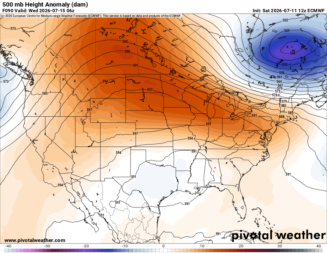
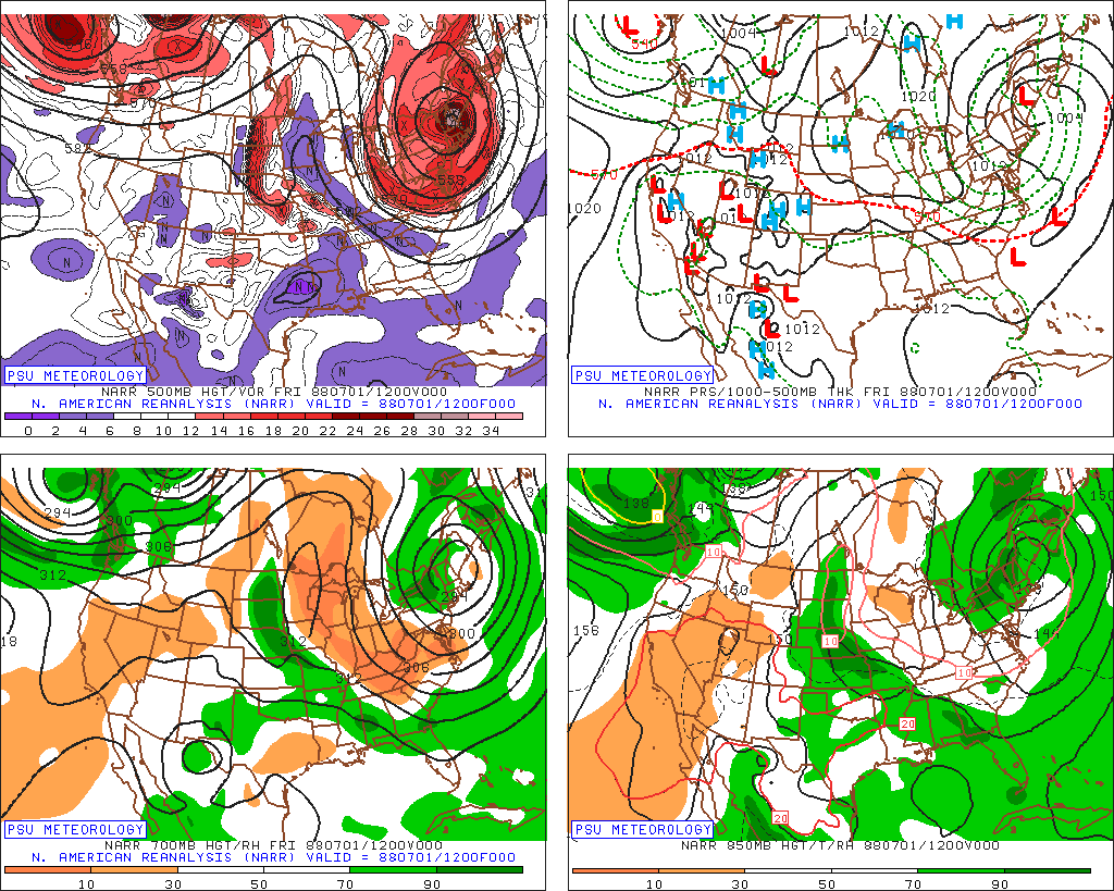
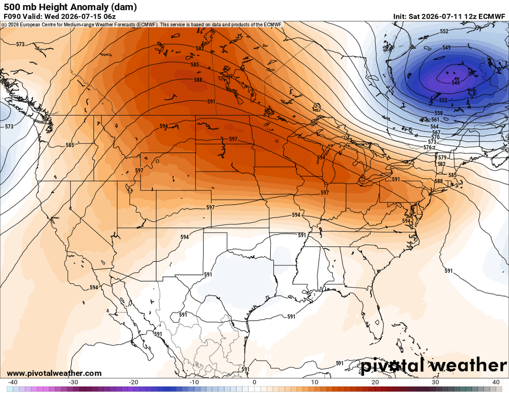
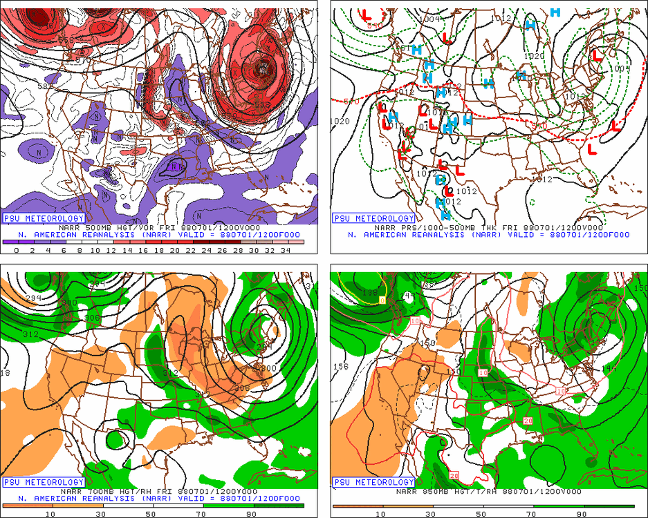
Are you referring to the cold low in Quebec? ECMWF at 90 hr shows the same as the GFS in terms of depth.
-
7/1/1988. 546 low over NNE. 4" of snow on MWN for its largest summer snowfall on record. 34 for a low at Barre Falls MA this day. And this occurred during one of most brutal summers for heat and drought in the CONUS on record. WxWiz is probably wondering..."I bet there were tons of low-topped tstms this day w/ hail!" Yes, there were!
-
Carol and Edna were only 10 days apart.
-
Bad/poor land/water management is a factor, more than it is ever said! It is the same for wildfires. When you have/had a policy to put all fires out as much and quick as possible, that has short-term gain, but the long-term issue is that available fuel builds up over time, and eventually, you end up w/ far worse wildfires. This the primary reason why we have seen so many massive wildfires in the U.S. and Canada in the last 10-15 years. Decades of fire suppression has lead to this situation.
-
That's b/c what "may" happen these days is all too often promoted as "WILL" happen! Low probably events are teased as a done deal. Also, we don't have many very strong El Ninos in the reliable period of record (since the sat era), so no way have we seen the full variance of what can happen w/ sensible wx in X or Y region.
-
He forget to mention BOS temp is running warm...
-
I am not a fan of the US Drought Monitor. I've seen a number of learned mets point out many times how mdt-svr drought conditions can exist when rainfall, soil moisture, reservoir levels, and the CMI/PMI are all solid, but *one* thing will be not good, such as snowpack, and that "ruins" it all. Seen this in WA/OR a number of times the last few years. I have little doubt there are political/social/economic factors that mess w/ the objectivity in some areas of the country. Havig drought conditions (a "problem") is a way to funnel/siphon $$. Declare a drought emergency, and that frees up state/federal funds, as one example. In some regards, it has become racket IMHO.
-
I wouldn't say nefarious, just misleading. The psychological part of viewers is well-known, what gets attention, and what does not. That's fine in itself, but as w/ anything, it can be abused or go off the rails. Back in the day, wx at TV stations was largely left alone, and sometimes plain disrespected. I interned at WNEV (now WHDH) in the late 80s, and I can't tell you how many times Harvey Leonard would get so ticked that they would cut the wx segment time 15 or 30 sec. Whenever the newscast needed to be trimmed as it was occurring, it was *always* was w/ the wxcast! This was regardless of what was going on currently or what was in the fcst. Could have a big storm on the way, and time would be still cut. Of course, that all changed after 1993 or so (Bliz of 93 was game changer). It was discovered there was big ratings in wx, and it went rather quickly from not enough time or attention to the opposite extreme. Wx became front and center in the newscast w/ endless teases and hits, and the amount of time an OCM had to actually put together fcst became less and less. The workload increased considerably w/ more complex graphic systems, the Internet, and then later social media. Wall-to-wall coverage for snowstorms or tornado warnings was never a routine thing, at least in the BOS TV market, until the later 90s. It took an exceptional event, like Hurricanes Gloria and Bob, for continuous news coverage for a wx event. Even CoastalWx became keen to this early on. Ask him about, "Nor'easter 95!" The only big snowstorm in the otherwise terrible 1994-95 season! I may sound like a curmudgeon at times, but that's not a inherently bad ting. Just have the experience of how things have changed over time. Change is inevitable, and it is not always bad, but things have become so crazy w/ wx over time, one is going to point things out, and yes, complain at times, esp. when it has to do w/ one's passion and profession!
-
Yes, esp. this time of year when large-scale dynamic forcing and strong low pressure areas are less, yet enough of a signal in the probs for SPC to outlook an area. NW flow aloft can lead to some of the best tornado events due to excellent directional shear. We have good speed shear very often, but strong directional shear is much less common. NW flow promotes lee troughing which can back the low-level winds, so you can over 90 deg turning sfc to 500 mb. And you tend to get solid EMLs for more CAPE overall.
- 1,481 replies
-
- 2
-

-
- severe
- thunderstorms
- (and 7 more)
-
K1L8 - Hurricane UT K68S - Davenport WA KE35 - Fabens TX KNWL - Corpus Christi/Waldron NOLF US TX KRIF - Richfield UT
-
That's odd given the much warmer and more humid climate. People do adapt over time and it's all what one is used to. I noticed it when I first moved to DC. The first couple of summers, it was a bit tough getting used to the persistent HHH wx in the summer (temps avg 6 deg higher in DCA than BOS), but by the 3rd summer, I had adapted. And it works the other way. This past winter was the coldest by far since I moved here, and it was noticeable that temps that I had no issues w/ in BOS were! We all have the same body temp. Yes, some ppl take the heat better, just like some take the cold better, but for the majority, it is about same. There is a reason why 68 F is considered room temp, as a reference standard. If the avg temp is in the low 90s and the DPs in the 70s in the summer, and that mets their criteria, that would mean a continuous state of alert/warning/advisory, and thus they lose their entire meaning! And since humans can live and thrive in areas of the globe that have heat indices 130+ most of the summer (e.g. Middle East), what, is the biology of humans in the U.S. somehow different that elsewhere on the globe?
-
CoastalWx mentioning national news reminded me of something. This is probably when I came to realize what wx had become in terms of treating the ordinary as extraordinary and the lack of scaling/quantification. In late July 2014 I was visiting a friend at a TV station in NJ, and the ABC Word News Tonight at 630 came on. And the lead story? "We begin tonight w/ svr wx w/ at least one tornado touching down..." This is what happened on this day. https://www.spc.noaa.gov/climo/reports/140724_rpts.html The tornado in question was in Edgewater FL. It was an EF0 and damaged some hangars and planes at the local airport. No one was hurt. This is national news? This is *local* story only. It was a minor event, par for the course any day in July for svr wx. You have 30 min to talk about news of the world, and this is material for such a newscast? Are you telling me that this is the best the staff of a national newscast can do for a story? It is lazy journalism and wx is low-hanging fruit. Don't get me wrong, wx on a national newscast is entirely relevant, but confine to something significant overall that has widespread impact or causes injuries/fatalities.
-
Just the topics of logical fallacies and cognitive biases *alone* is so much material. And we can all relate to them well b/c we are all susceptible and/or committed them at one time or another, and have experienced it first hand among the population and media.
-
Attractive headlines I have no issue w/ on a fundamental level, and they do have plenty of value, but as w/ anything, it can be abused, and that abuse line was crossed a long time ago IMHO. You wrote: "It is always best to ignore the hype in weather and sports... " I agree 100%, but it's very hard to b/c it is everywhere! Yes on social media platforms you can block words/phrases and ppl/sites, but it doesn't catch everything. Just casually watching TV or listening to radio, or ads on on sites like YouTube, it gets you. And over time, the drama, hype, and negative has worked their way into everything. You can't even have escapism watching a movie or show anymore w/o some kind of messaging or virtue signaling randomly inserted that has zero to do w/ the plot, but put in anyways.