MN Transplant
-
Posts
17,845 -
Joined
-
Last visited
Content Type
Profiles
Blogs
Forums
American Weather
Media Demo
Store
Gallery
Everything posted by MN Transplant
-
Fess up, who broke the official 5-minute obs? 85.6
-
2023 Mid-Atlantic Severe Wx Thread (General Discussion)
MN Transplant replied to Kmlwx's topic in Mid Atlantic
Some UH swaths across DC on the 12z NAM Nest- 2,785 replies
-
- 1
-

-
- severe
- thunderstorms
- (and 3 more)
-
81.1 at noon. Too soon.
-
Low of 60.8. Very late May/early June outside.
-
Record high at DCA is 86 tomorrow. In danger if the HRRR and GFS are right. The caveat being river wind in April.
-
Slant sticking
-
Here we go based on the F6s. These are more what I recall.
-
Yes, I couldn’t find the peak gust numbers in the daily obs. I was going off the hourly Metars. Maybe I need to look at the F6s?
-
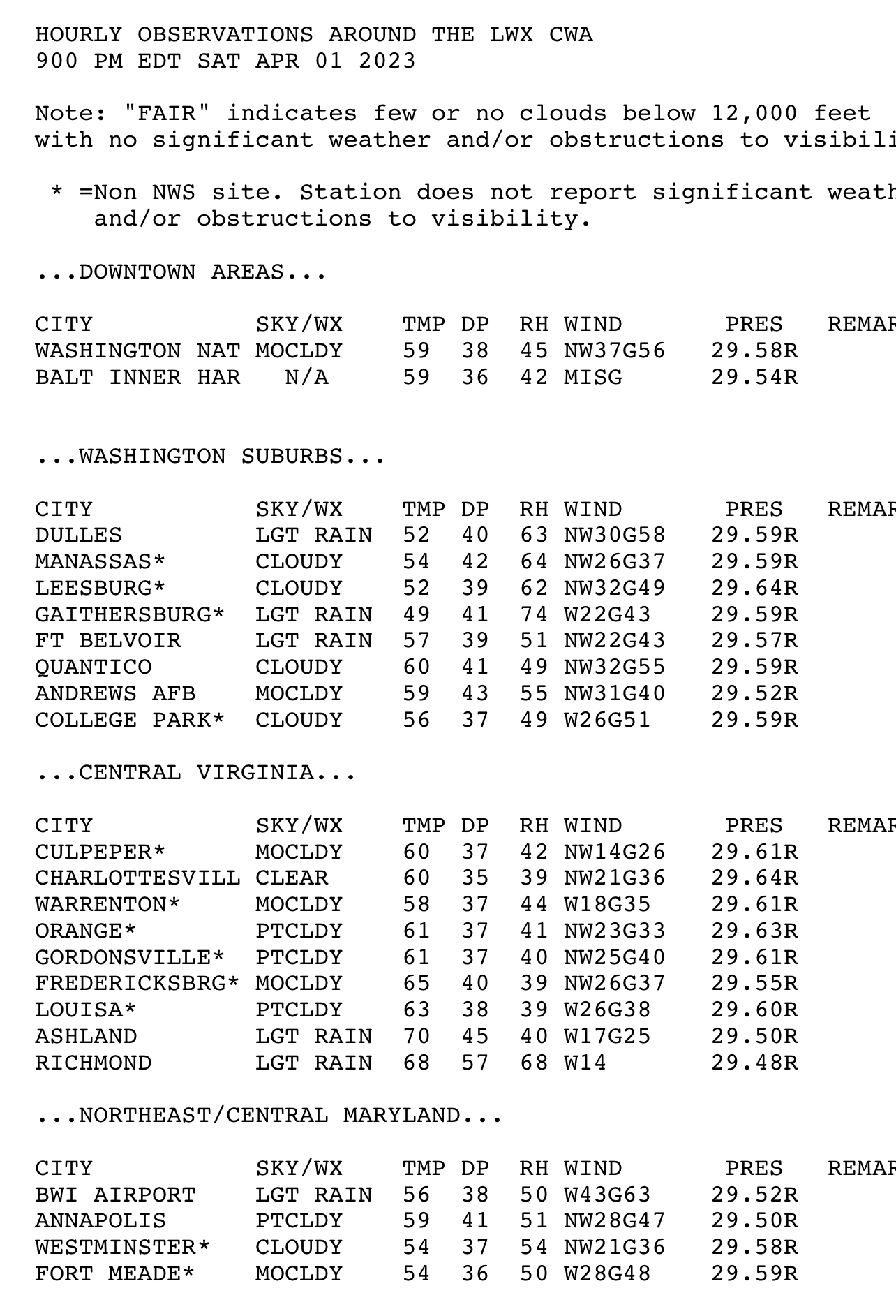
Of interest only to me, but I thought I would share anyway. This is a catalog of every 40mph+ gust that my weather station in Falls Church has recorded, with comparisons to IAD/DCA. I have a pretty good mounting location above my roofline, but we are surrounded by 100' oaks so it does read low, especially after leaf-out. Still bummed that I lost power in two of the bigger region-wide events (derecho and Mar. 2018). The localized downburst in August 2021 caused much more damage in my neighborhood than any other event in the past decade-plus, derecho included. Edit - new list below
- 809 replies
-
- 10
-
-
It is an amazing winter up there. It hasn't even been that cold, mostly near normal, but they are just getting nailed over and over.
-
For posterity: 000 NOUS41 KLWX 020310 PNSLWX DCZ001-MDZ001-003>006-008-011-013-014-016>018-501>508-VAZ025>031- 036>040-050>057-501>508-WVZ050>053-055-501>506-021510- Public Information Statement Spotter Reports National Weather Service Baltimore MD/Washington DC 1110 PM EDT Sat Apr 01 2023 The following are unofficial observations taken during the past 10 hours for the storm that has been affecting our region. Appreciation is extended to cooperative and CoCoRaHS observers, Skywarn spotters and media for these reports. This summary also is available on our home page at weather.gov/baltimore **************PEAK WIND GUST (AT LEAST 46 MPH)************** LOCATION MAX WIND TIME/DATE COMMENTS GUST MEASURED (mph) DISTRICT OF COLUMBIA ...District of Columbia... Gwu Mount Vernon Cam 64 1000 PM 4/01 MESOWEST Catholic University 58 933 PM 4/01 Mesonet Gwu Foggy Bottom Cam 56 640 PM 4/01 MESOWEST Washington; DC 49 948 PM 4/01 NOS-NWLON MARYLAND ...Allegany County... Frostburg 1 S 60 234 PM 4/01 Mesonet Md-51 At Oldtown Sal 53 514 PM 4/01 MESOWEST Cumberland 1 WNW 51 249 PM 4/01 Mesonet I-68 At Savage Mt 50 201 PM 4/01 MESOWEST Oldtown 49 333 PM 4/01 CWOP Md-135 At Salt Dome 46 204 PM 4/01 MESOWEST ...Anne Arundel County... BWI Marshall Airport 63 854 PM 4/01 ASOS I-97 At Md-100 63 834 PM 4/01 MESOWEST Annapolis Naval 58 855 PM 4/01 ASOS Annapolis; MD 54 900 PM 4/01 NOS-NWLON Us-50 At Md-2 52 859 PM 4/01 MESOWEST Fort Meade 49 629 PM 4/01 AWOS Glen Burnie 47 920 PM 4/01 CWOP ...ANZ531... Bowleys Quarters 1 E 61 903 PM 4/01 Mesonet Tolchester Beach NOS 55 930 PM 4/01 NOS-PORTS Annapolis 51 846 PM 4/01 CWOP ...ANZ532... Bay Ridge 1 NNE 63 854 PM 4/01 NDBC Bay Ridge 2 SSE 53 800 PM 4/01 NDBC ...ANZ533... Cove Point LNG Pier; 47 918 PM 4/01 NOS-PORTS ...ANZ537... Piney Point; MD 52 806 PM 4/01 NOS-PORTS Hull Neck 5 NNE 47 942 PM 4/01 NDBC ...ANZ538... Dundalk 3 SSW 68 912 PM 4/01 NDBC Francis Scott Key Br 60 918 PM 4/01 NOS-PORTS ...ANZ542... Solomons Island; MD 46 530 PM 4/01 NOS-NWLON ...ANZ543... Bishops Head; MD 50 812 PM 4/01 NOS-NWLON ...Baltimore County... Owings Mills 54 915 PM 4/01 CWOP Md-43 At Md-150 51 914 PM 4/01 MESOWEST ...Carroll County... Md-30 At Pa Line 51 834 PM 4/01 MESOWEST Sykesville 49 855 PM 4/01 CWOP New Windsor 46 836 PM 4/01 CWOP ...Cecil County... North East MD-Landfi 60 940 PM 4/01 DEOS2 West Nottingham 50 904 PM 4/01 Mesonet ...Charles County... Md 231 At Patuxent R 53 1015 PM 4/01 MESOWEST ...Frederick County... Woodsboro 3 E 68 820 PM 4/01 Mesonet Us-340 At Md-180 62 934 PM 4/01 MESOWEST Ballenger Creek 2 NE 56 850 PM 4/01 MESOWEST Keymar 55 815 PM 4/01 CWOP Us-15 At Md-140 52 759 PM 4/01 MESOWEST Mount Airy 2 NNE 49 915 PM 4/01 Mesonet Frederick 48 747 PM 4/01 AWOS Thurmont 46 820 PM 4/01 CWOP ...Garrett County... I-68 At Us 219 59 146 PM 4/01 MESOWEST Mc Henry 2 NW 49 205 PM 4/01 AWOS Garrett County Airpo 49 205 PM 4/01 AWOS I-68 at WV Line 48 234 PM 4/01 MESOWEST ...Harford County... Jarrettsville 46 906 PM 4/01 CWOP ...Howard County... Elkridge 48 850 PM 4/01 CWOP I-70 At Md-32 47 1009 PM 4/01 MESOWEST ...Montgomery County... Cabin John 65 849 PM 4/01 CWOP Md-200 Eb At Bonifan 47 851 PM 4/01 MESOWEST Darnestown1-SW 46 615 PM 4/01 CWOP ...Prince Georges County... Upper Marlboro 62 910 PM 4/01 Mesonet I-95 495 At I-295 57 704 PM 4/01 MESOWEST Andrews AFB 54 713 PM 4/01 AWOS College Park Airpor 51 910 PM 4/01 AWOS Laurel 51 900 PM 4/01 CWOP Riverdale 51 900 PM 4/01 CWOP College Park 46 910 PM 4/01 CWOP ...St. Marys County... Webster Field 63 807 PM 4/01 AWOS Patuxent River NAS 53 934 PM 4/01 AWOS ...Washington County... Md-64 At Md-418 58 609 PM 4/01 MESOWEST Ringgold 58 609 PM 4/01 Dept of Highways I-70 At I-81 58 814 PM 4/01 MESOWEST Hagerstown Rgnl Arpt 55 602 PM 4/01 ASOS I-68 At Sideling Hil 53 439 PM 4/01 MESOWEST I-70 At Fred-Wash Co 47 619 PM 4/01 MESOWEST Hagerstown 46 615 PM 4/01 CWOP VIRGINIA ...Albemarle County... Covesville 1 SE 63 644 PM 4/01 Mesonet Greenwood 2 NNE 53 959 PM 4/01 Mesonet White Hall 5 NNW 49 755 PM 4/01 Mesonet Barracks 2 S 48 610 PM 4/01 MESOWEST ...ANZ536... Quantico Marine Corp 56 831 PM 4/01 AWOS ...Arlington County... Reagan National Arpt 58 935 PM 4/01 ASOS ...Augusta County... Afton 3 SW 62 630 PM 4/01 Mesonet Weyers Cave 49 549 PM 4/01 CWOP ...City of Charlottesville... Barracks 1 SE 46 640 PM 4/01 MESOWEST ...City of Manassas... Manassas Rgnl Arpt 52 830 PM 4/01 AWOS ...Clarke County... Briggs 3 ESE 51 620 PM 4/01 Mesonet ...Fairfax County... Dulles Intl Airport 68 834 PM 4/01 ASOS Davison Army Airfld 55 827 PM 4/01 AWOS I-495 At American Le 49 649 PM 4/01 MESOWEST ...Fauquier County... Cresthill 2 N 57 944 PM 4/01 Mesonet Bristersburg 2 NE 47 629 PM 4/01 Mesonet ...Frederick County... Stephens City 3 NNW 55 554 PM 4/01 Mesonet Winchester Rgnl Arpt 49 835 PM 4/01 AWOS ...Greene County... Quinque 47 848 PM 4/01 CWOP ...Highland County... Monterey 1 SW 57 414 PM 4/01 Mesonet New Hampden 1 SSW 47 245 PM 4/01 Mesonet ...Loudoun County... Lovettsville 55 808 PM 4/01 CWOP Leesburg Exec Arpt 55 835 PM 4/01 AWOS Philomont 51 1025 PM 4/01 CWOP Gwu Virginia Science 50 840 PM 4/01 MESOWEST Lovettsville 3 W 48 614 PM 4/01 Mesonet ...Madison County... Madison 50 945 PM 4/01 CWOP ...Nelson County... Wintergreen 2 SW 55 1014 PM 4/01 Mesonet ...Prince William County... Aden 2 W 52 709 PM 4/01 Mesonet ...Rappahannock County... Boston 59 916 PM 4/01 CWOP Castleton 1 WNW 55 929 PM 4/01 Mesonet ...Rockingham County... Mount Crawford 3 ENE 55 554 PM 4/01 Mesonet Bridgewater 55 735 PM 4/01 AWOS Massanutten 2 SSE 49 744 PM 4/01 Mesonet Clover Hill 1 W 48 909 PM 4/01 Mesonet ...Shenandoah County... Seven Fountains 3 WN 55 738 PM 4/01 Mesonet ...Warren County... Linden 2 SW 48 315 PM 4/01 Mesonet WEST VIRGINIA ...Berkeley County... Martinsburg Arpt 52 605 PM 4/01 ASOS ...Grant County... Bismarck 5 SSW 62 500 PM 4/01 Mesonet Petersburg 1 W 51 544 PM 4/01 AWOS Petersburg 1 NE 48 508 PM 4/01 Mesonet ...Hampshire County... Frenchburg 3 WNW 49 550 PM 4/01 Mesonet ...Hardy County... Lost River 1 NE 59 949 PM 4/01 Mesonet Moorefield 49 530 PM 4/01 MESOWEST ...Mineral County... Cumberland Reg 48 245 PM 4/01 AWOS Reeses Mill 2 WNW 46 255 PM 4/01 Mesonet ...Pendleton County... Upper Tract 52 517 PM 4/01 RAWS Riverton 2 SW 48 934 PM 4/01 Mesonet
-
Briefly lost power twice (seconds). Good event.
-
Dominion has 18.5k out in Northern VA. Not too bad.
-
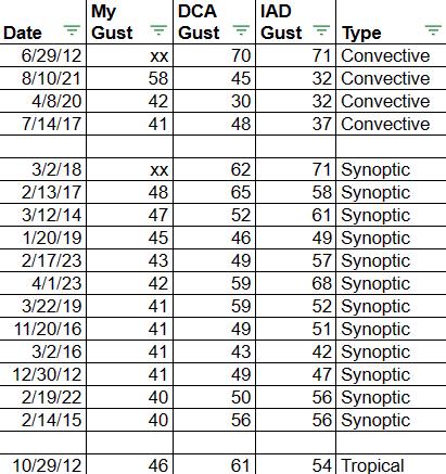
Good one to save. The three airports plus Quantico all above 55.

-
Looks like they are still landing on the runway that is into the wind (obviously)
-
Gust to 59kt at IAD!
-
Now it is getting loud
-
51 at IAD and 58 at DCA, but I’m not sure I’ve hit 40.
-
Wonder if this is getting down
-
500k w/o power in OH/PA
-
My brother west of Frederick just got his top wind gust in the last two years at 45mph, which is pretty good since his anemometer is at like 5’.
-
Pittsburgh to 63 with the line of storms. 40s and 50s across Ohio.
-
71.4. Pretty cool how the winds died after the rain set up an inversion, and now they are ever so slightly increasing as the surface warms and mixes the boundary layer.
-
Winds already kicking up. Gust to 44 at IAD.
-
2023 Mid-Atlantic Severe Wx Thread (General Discussion)
MN Transplant replied to Kmlwx's topic in Mid Atlantic
Moving this over here. The 18z NAM is more aggressive on the potential for severe due to the low-level moisture. Check out the difference between 12z and 18z..png.1793ca0c653d6676f5ceac59d2658cae.png)
- 2,785 replies
-
- 6
-
-

-
- severe
- thunderstorms
- (and 3 more)