MN Transplant
-
Posts
17,845 -
Joined
-
Last visited
Content Type
Profiles
Blogs
Forums
American Weather
Media Demo
Store
Gallery
Everything posted by MN Transplant
-
Heck of a fire from a tanker truck crash in Frederick
-
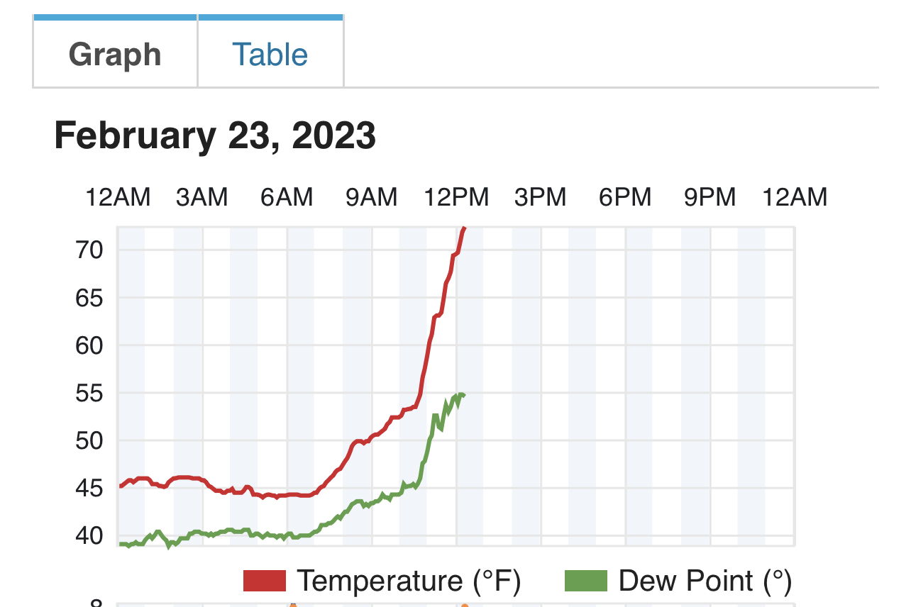
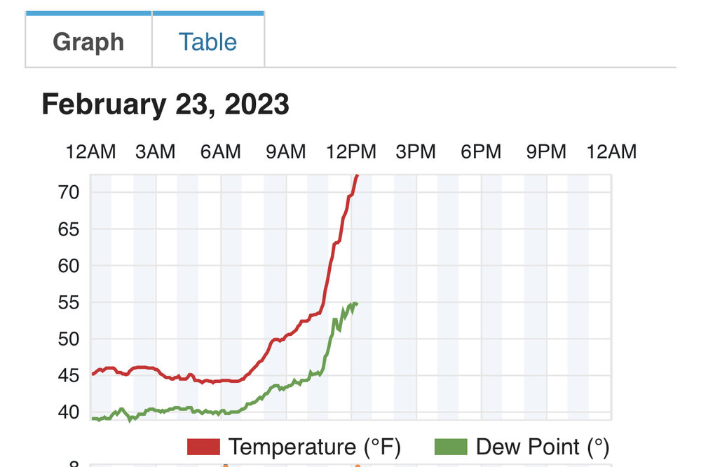
Going to have a unique 3:30pm low temp today
-
The HRRR is quite aggressive tomorrow for wind gusts in the afternoon. NAM seems more realistic.
-
Still might be stolen.
-
A little disorienting at 3:30am. Took me a minute to figure out what was happening!
-
That's wild. It looks like the temps briefly dropped to the upper 40s in Newport Beach which must have been just good enough.
-
Bottom 6 all in the last 30 years.
-
Nice article by CWG today that shows that March temps have a very large impact on the bloom dates, and since we are looking at pretty average temps the fast start will be muted.
-
Brutal
-
The snow lovers in Vermont will be happy
-
If you wanted to draw up a start to the warmest year on record, this is how you'd do it.
-
Yes, add 2014 to DCA. March 1999 was a little before the timeframe we are talking about (3/9/99). Precisely. Everything is just so stacked against us by this late in the season that expectations need to be well in check. That said, it would be so fun to have a Palm Sunday 1942 event.
-
DCA's climo is just awful as you get to Mid-March. The last time there was a 6"+ snowstorm in Mid-March or later was the '93 superstorm. Prior to that was 1942. IAD has at least scored a couple of other times, in 1964 and 2014. All of BWI's 6"+ events appear to be 1964 or prior, with the exception of '93. But I'm sure we'll score in the warmest year on record.
-
That’s the route to a win on this storm. It is going to the Ohio Valley, but can we get something on the front end.
-
02/25 Light Snow Chance Disco/Obs
MN Transplant replied to NorthArlington101's topic in Mid Atlantic
Nice snow TV. 34.9 -
Top report I’ve seen from the southern MSP burbs was 19”. The widespread 18”+ didn’t materialize, but most seem to have ended up with 12-16”. A little disappointing based on the hype, but they were really leaning into ratios to make those numbers and that is a tough game to play.
-
76.1 in Falls Church. Torch activated.
-
Like a rocket
-
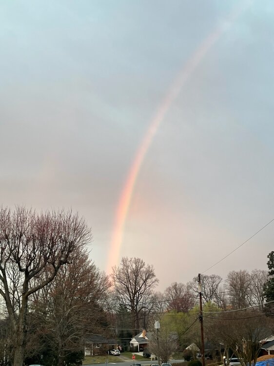
A rare morning rainbow to the west
- 493 replies
-
- 13
-

-
Here's a really interesting aspect of the storm this week in Minneapolis. Of the top 24 snowfalls (which are relatively modest due to the distance from moisture sources), you have to go down to #20 to get to one that is in February. The storm track is usually shunted south. Also note that 3 and 4 are in the same week, their version of Feb. 2010. https://www.dnr.state.mn.us/climate/journal/top_twenty_snowfalls.html Top Twenty Snowfalls for Twin Cities 1. 28.4 inches: 1991 October 31 - November 3 (Halloween Blizzard) 2. 21.1 inches: 1985 November 29 - December 1 (Thanksgiving Weekend) 3. 20.0 inches: 1982 January 22 - 23 4. 17.4 inches: 1982 January 20 - 21 5. 17.1 inches: 2010 December 10 - 11 (Final "Domebuster") 6. 16.8 inches: 1940 November 11 - 13 (Armistice Day) 7. 16.7 inches: 1985 March 3 - 4 7. 16.7 inches: 1940 March 11 - 14 (tie) 9. 16.5 inches: 1982 December 27 - 28 10. 16.0 inches: 1917 January 20 - 21 10. 16.0 inches: 1999 March 8 - 9 (tie) 12. 15.8 inches: 2018 April 13-16 (Thunder Blizzard) 13. 15.3 inches: 1886 November 16-18 14. 15.1 inches: 2023 January 2-5 (Big Mess) 15. 14.7 inches: 1985 March 31 16. 14.3 inches: 1991 November 29 - 30 (Black Friday) 17. 14.1 inches: 1952 March 22 -23 17. 14.1 inches: 1983 November 27 - December 1 (tie) 19. 14.0 inches: 1899 March 10-12 20. 13.8 inches: 2011 February 20-21 21. 13.6 inches: 1966 March 22-23 21. 13.6 inches: 1983 April 14 (tie) 23. 13.1 inches: 1983 December 13-15 24. 13.0 inches: 1907 April 27-28
-
Thursday afternoon it is going to be in the upper 70s here, and it will be about 10 degrees with winds blowing around 12-18+" of new snow back home. I'll enjoy the warmth, but it'll be a bummer seeing all the pictures.
-
Good catch. Timing is ideal with the winds swinging through at mid afternoon peak surface heating. 3km NAM has it too.
-
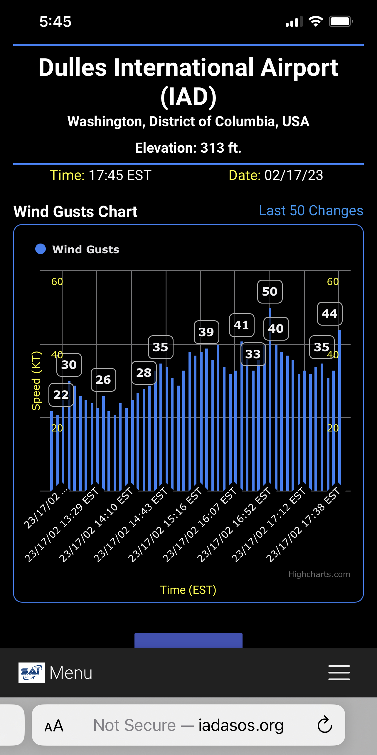
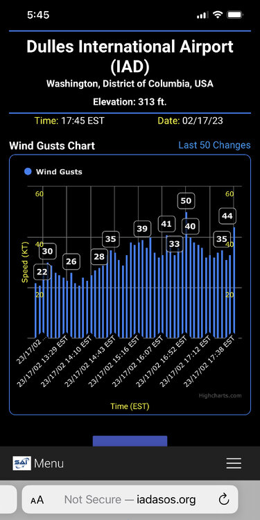
Really solid gusts
-
The most interesting thing about the 22-23 map is around Erie and Ontario. The big LE storm events have been long-lake bands and the Oswego-like areas have been left out.
-
Just got a 43mph gust. Down 18 degrees from the high.