MN Transplant
-
Posts
17,834 -
Joined
-
Last visited
Content Type
Profiles
Blogs
Forums
American Weather
Media Demo
Store
Gallery
Everything posted by MN Transplant
-
0.47”. I’ll take it, but we desperately need a region-wide soaker.
-
Yes, via my metrics of if it is loud enough to bother the dogs. I’ve heard thunder in the distance this year, but no close strikes until today.
-
Thunderstorm #1 of 2026 confirmed!
-
#alwaysmaryland
-
92/79 for a 109 HI
-
The rain that fell last week around DC wasn’t enough to keep up with climo. DCA now -7.44” ytd.
-
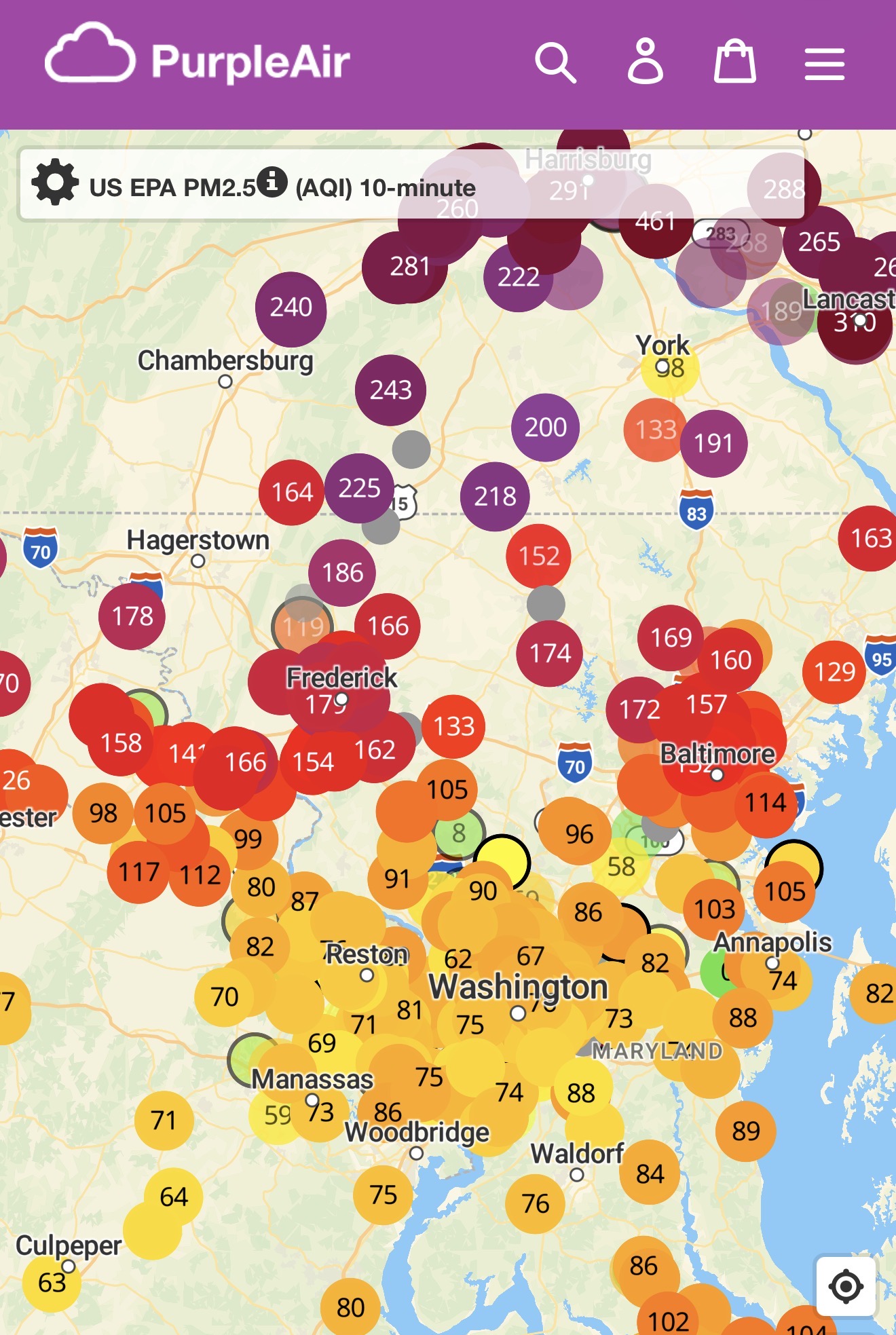
I don't know about vanished. I just drove into Tysons and it still pretty gross. AQIs are hovering around 200 in the western Beltway area.
-
Yeah, it is bad, but it is not as awful as 7-8am. I'm down to 191. Hopefully any additional pulses won't equal this morning's mess.
-
000SXUS71 KLWX 170650RERIADRECORD EVENT REPORTNATIONAL WEATHER SERVICE BALTIMORE MD/WASHINGTON DC 0250 AM EDT FRI JUL 17 2026...RECORD DAILY AND ALL TIME WARM MINIMUM TEMPERATURE SET AT WASHINGTON DULLES DC...A RECORD DAILY WARM MINIMUM TEMPERATURE OF 81 DEGREES WAS SET AT WASHINGTON DULLES INTERNATIONAL AIRPORT NEAR WASHINGTON DC YESTERDAY...JULY 16. THIS BREAKS THE OLD DAILY RECORD OF 74 DEGREES SET IN 2013.THIS IS ALSO AN ALL TIME RECORD WARM LOW TEMPERATURE. THE PREVIOUS RECORD WAS 79 DEGREES SET ON AUGUST 8 2007...WHICH MEANS THIS WAS THE FIRST TIME IN RECORDED HISTORY THAT DULLES HAD A LOW TEMPERATURE OF AT LEAST 80 DEGREES.WEATHER RECORDS FOR THE DULLES AREA HAVE BEEN RECORDED AT WHAT IS NOW WASHINGTON DULLES INTERNATIONAL AIRPORT SINCE 1960. THE OFFICIAL RECORD CONSISTS SOLELY OF DATA RECORDED AT THE AIRPORT. TEMPERATURE AND PRECIPITATION RECORDS BEGAN IN 1960. SNOWFALL RECORDS BEGAN IN 1962.ALL CLIMATE DATA ARE CONSIDERED PRELIMINARY UNTIL REVIEWED BY THE NATIONAL CENTERS FOR ENVIRONMENTAL INFORMATION (NCEI).$$
-
The specific smell is what I remember from a few years ago. Not a campfire smell, but an acrid, completely unpleasant smell. My AQI is hovering around 300. IAD and DCA are near 1 mile visibility.
-
It’s coming

-
Scrolling around trying to find the worst ob. Philly's 95 with 6 mile viz is a candidate. Grand Rapids, MI with an 88 and 3/4 mile viz is another. HGR is entering the game with 91 and 4 miles.
-
Airports still had a good run today and the HIs got in the 105-110 range in a good chunk of the region. DCA: 98 IAD: 96 BWI: 95
-
I’ve been using surface viz as a proxy for how it will seem at the ground level, but yeah, it is going to be smoky in the column.
-
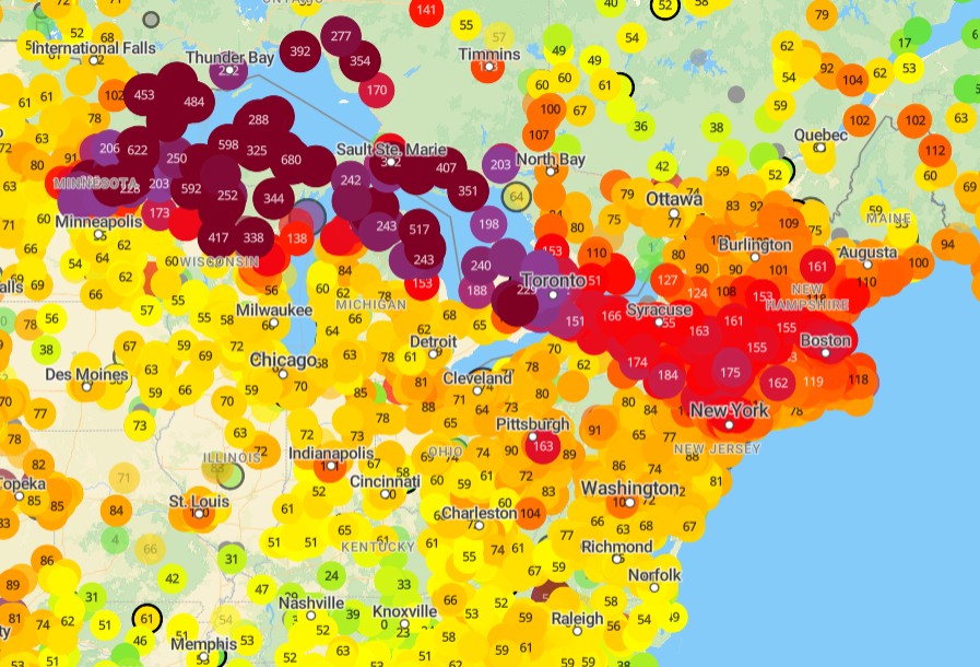
Good news is that the HRRR is being less aggressive on the smoke over the past several runs. Bad news is that it is undershooting the visibility reduction in the Great Lakes right now. Much of WI and MI have 1 mile or less visibility.
-
There’s a 1500 near the Canadian border in the Minnesota arrowhead region. I looked at the trace and they topped 2000 yesterday.
-
To be clear, IAD has never recorded an 80+ low for any day. The morning low was 81. The question is whether it falls below 80 by the end of the day. It did drop down to 79 last evening when the winds went calm, and then rose again before midnight.
-
We might finally break the all-time warm low record at Dulles. Doesn’t look like they’ve broken below 80.
-
DCA is taking advantage of the west wind. Up to 93. Milky sky, but not a ton of irradiance reduction today. 90.5 at home. Likely a late high day as the warm pocket aloft is still advecting in.
-
Not only Canada, the Boundary Waters area of northern MN has lightning-induced fires and they've closed the park for only the third time on record.
-
Nasty
-
Probably not too much of a leap to think that the smoke might be holding temps back a bit.
-
The 00z sounding from last evening had the highest 500mb height on record at Minneapolis (1957-forward).
-
With Norway out, now I just want a toxic as hell France/England final.
-
0.67” at DCA. 0.20” at home. Nice refresher.