

MN Transplant
-
Posts
17,859 -
Joined
-
Last visited
Content Type
Profiles
Blogs
Forums
American Weather
Media Demo
Store
Gallery
Everything posted by MN Transplant
-
Big Heat (and storms?) Week into July 4th Weekend
MN Transplant replied to yoda's topic in Mid Atlantic
10:30am and we have our first couple of mesonet sites hitting 110 HI. -
Big Heat (and storms?) Week into July 4th Weekend
MN Transplant replied to yoda's topic in Mid Atlantic
One good thing that I'm seeing is that the new RRFS seems to be handling this a lot better than the HRRR. The HRRR is out of control with mixing out the boundary layer, with places like Fredericksburg with something like 108/55 tomorrow. Conversely, the RRFS is a reasonable 102/69 for tomorrow. -
Big Heat (and storms?) Week into July 4th Weekend
MN Transplant replied to yoda's topic in Mid Atlantic
My annual warning for reading the 5-minute obs. Because of rounding, a 5-minute reading of 99 could mean 98 or 99. A reading of 100 is 100. -
Big Heat (and storms?) Week into July 4th Weekend
MN Transplant replied to yoda's topic in Mid Atlantic
9am temps. DCA: 88 IAD: 87 BWI: 89 88.3 at home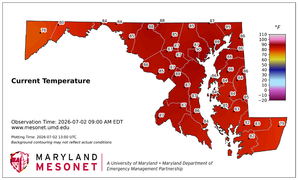
-
Big Heat (and storms?) Week into July 4th Weekend
MN Transplant replied to yoda's topic in Mid Atlantic
Immediately as there was a west wind -
Fireworks Heat Contest W 7/1 - S 7/4 for Five MA Airports
MN Transplant replied to nw baltimore wx's topic in Mid Atlantic
You and I have to be feeling good about staying on the low side for SBY. -
Big Heat (and storms?) Week into July 4th Weekend
MN Transplant replied to yoda's topic in Mid Atlantic
The max on the mesonet was 97 and IAD/BWI were also in the 97 range. I think we generally were not quite there yet with the overall environment and the DPs didn’t help. Feels like tomorrow and Friday are likely triple digits though. -
Big Heat (and storms?) Week into July 4th Weekend
MN Transplant replied to yoda's topic in Mid Atlantic
I like the pink lines for 110+. Color gradient gets tough at that point. -
Big Heat (and storms?) Week into July 4th Weekend
MN Transplant replied to yoda's topic in Mid Atlantic
105 HI on the first day of a heat wave with a river wind is something else. -
Big Heat (and storms?) Week into July 4th Weekend
MN Transplant replied to yoda's topic in Mid Atlantic
Temps are running on the low side of (the crazy) guidance but that is being overwhelmed by the DPs being higher. -
Big Heat (and storms?) Week into July 4th Weekend
MN Transplant replied to yoda's topic in Mid Atlantic
I was hoping the drought would help keep the DPs down. That is not happening. 91.4/76 -
If I counted correctly, that was the 10th driest first half of the year in the DCA record, but you only have to go back to 2023 to beat it.
-
Fireworks Heat Contest W 7/1 - S 7/4 for Five MA Airports
MN Transplant replied to nw baltimore wx's topic in Mid Atlantic
DCA: 98, 101, 102, 97 BWI: 98, 101, 102, 97 IAD: 98, 101, 102, 97 SBY: 91, 98, 98, 97 RIC: 96, 98, 100, 98 Total Rain: 1.34" -
Big Heat (and storms?) Week into July 4th Weekend
MN Transplant replied to yoda's topic in Mid Atlantic
The thing that helped 2024 was that it was really dry in that period. It’ll be interesting to see if this weekend’s rain has any affect by later this week. -
My temp has been 69 or 70 the entire day. Up to 0.37” since midnight, very much a small drop, warm rain process happening today.
-
Big Heat (and storms?) Week into July 4th Weekend
MN Transplant replied to yoda's topic in Mid Atlantic
It was 10am. -
Big Heat (and storms?) Week into July 4th Weekend
MN Transplant replied to yoda's topic in Mid Atlantic
2pm temps Wed-Sat at DCA from the 00z or 06z runs on 6/28: Operational Runs: Euro: 95/102/105/104 GFS: 99/101/103/102 ICON: 96/102/105/105 GDPS: 98/102/103/102 AI Runs EuroAI: 97/100/101/98 AIGFS: 96/99/101/96 Ensembles EPS: 97/103/104/99 GEFS: 99/101/99/97 EuroAI: 99/102/99/95 CMCE: 99/103/104/96 -
The 3km NAM has a couple of 6-7" bullseyes for later today in the area. Of course, it has a 4" one this morning and nobody is getting that, so trust level = low. 0.32" since Friday.
-
I really don't know what the NWS is thinking by putting 104 and 105 into the zones. You don't forecast historic heat 4-5 days out, especially when the only guidance giving those types of numbers are models that have known boundary layer issues. From the AFD: ================================================================== *** ALL-TIME RECORD HIGHS *** ================================================================== Baltimore 107 (set on Jul 10, 1936) Washington 106 (set on Jul 20, 1930 + Aug 06, 1918) Sterling-Dulles Airport 105 (set on Jul 22, 2011) Baltimore Downtown 108 (set on Jul 07, 2012 + Jul 22, 2011) Annapolis 106 (set on Aug 06, 1918) Hagerstown 105 (set on Jul 14, 1954) Martinsburg 112 (set on Jul 11, 1936) Charlottesville 107 (set on Sep 07, 1954 + 3 other times) ================================================================== *** ALL-TIME RECORD WARM LOWS *** ================================================================== Baltimore 83 (set on Aug 05, 1930 + 2 other times) Washington 84 (set on Jul 24, 2011 + 2 other times) Sterling-Dulles Airport 79 (set on Aug 08, 2007) Baltimore Downtown 88 (set on Jul 02, 2011 and Jul 10, 1993) Annapolis 92 (set on Jul 07, 1994) Hagerstown 86 (set on Jun 15, 1899) Martinsburg 86 (set on Jul 21, 1930) Charlottesville 85 (set on Aug 07, 1918) ================================================================== *** JULY MONTHLY RECORD HIGHS *** ================================================================== Baltimore 107 (set on Jul 10, 1936) Washington 106 (set on Jul 20, 1930) Sterling-Dulles Airport 105 (set on Jul 22, 2011) Baltimore Downtown 108 (set on Jul 07, 2012 + Jul 22, 2011) Annapolis 105 (set on Jul 21, 1930 + Jul 02, 1901) Hagerstown 105 (set on Jul 14, 1954) Martinsburg 112 (set on Jul 11, 1936) Charlottesville 107 (set on Jul 10, 1936 + Jul 20, 1930) ================================================================== *** JULY MONTHLY RECORD WARM LOWS *** ================================================================== Baltimore 83 (set on Jul 21, 1930) Washington 84 (set on Jul 24, 2011 + 2 other times) Sterling-Dulles Airport 78 (set on Jul 24, 2010 + Jul 08, 2010) Baltimore Downtown 88 (set on Jul 22, 2011 + Jul 10, 1993) Annapolis 92 (set on Jul 07, 1994) Hagerstown 83 (set on Jul 24, 2010) Martinsburg 86 (set on Jul 21, 1930) Charlottesville 84 (set on Jul 22, 1930) ================================================================== *** DAILY RECORD HIGHS | WARM LOWS *** VALID: Jul 01 ================================================================== Baltimore 103 (1901) | 80 (1933 + 1901) Washington 102 (1901) | 79 (1977) Sterling-Dulles Airport 96 (2012) | 72 (2017 + 3) Baltimore Downtown 101 (2012) | 82 (2012) Annapolis 103 (1901) | 79 (1945 + 1901) Hagerstown 100 (1901) | 74 (2017 + 1977) Martinsburg 102 (1933) | 74 (1933) Charlottesville 101 (2012 + 1945) | 78 (1901) ================================================================== *** DAILY RECORD HIGHS | WARM LOWS *** VALID: Jul 02 ================================================================== Baltimore 103 (1901) | 80 (1901) Washington 101 (1898) | 79 (2012 + 1872) Sterling-Dulles Airport 98 (1966) | 75 (2022) Baltimore Downtown 102 (1966) | 84 (2002) Annapolis 105 (1901) | 80 (1901) Hagerstown 100 (1966) | 74 (2018 + 1901) Martinsburg 102 (1933 + 1931) | 75 (1933 + 1901) Charlottesville 100 (1954) | 76 (1910) ================================================================== *** DAILY RECORD HIGHS | WARM LOWS *** VALID: Jul 03 ================================================================== Baltimore 104 (1898) | 80 (1898) Washington 101 (1966 + 2) | 80 (2018) Sterling-Dulles Airport 103 (1966) | 73 (2018 + 2) Baltimore Downtown 102 (1997) | 82 (2018 + 1983) Annapolis 100 (1901) | 84 (1896) Hagerstown 102 (1966) | 76 (2002) Martinsburg 102 (1941 + 1911) | 74 (1980) Charlottesville 100 (1966 + 1954) | 79 (1911)
-
I mean, it’s the same thing when there’s a winter ridge out west and the east coast is in a deep freeze. I wonder how many people realize just how extreme the winter was in the intermountain west. And anthropogenic climate change is extremely real, no matter what the media is fixated on at any time.
-
Huh, interesting Flood Watch National Weather Service Baltimore MD/Washington DC 414 PM EDT Sat Jun 27 2026 .A cold front has stalled over the DC metro. Increasing humidity is expected to lead to showers and thunderstorms with heavy rain through this evening. DCZ001-MDZ013-014-504-VAZ053-054-280200- /O.NEW.KLWX.FA.A.0002.260627T2014Z-260628T0200Z/ /00000.0.ER.000000T0000Z.000000T0000Z.000000T0000Z.OO/ District of Columbia-Prince Georges-Anne Arundel-Central and Southeast Montgomery-Fairfax-Arlington/Falls Church/Alexandria- 414 PM EDT Sat Jun 27 2026 ...FLOOD WATCH IN EFFECT UNTIL 10 PM EDT THIS EVENING... * WHAT...Flash flooding caused by excessive rainfall is possible. * WHERE...Washington DC, portions of central Maryland, including the following areas, Anne Arundel, Central and Southeast Montgomery and Prince Georges, and northern Virginia, including the following areas, Arlington/Falls Church/Alexandria and Fairfax. * WHEN...Until 10 PM EDT this evening. * IMPACTS...Flooding may occur in poor drainage and urban areas. Storm drains and ditches may become clogged with debris. * ADDITIONAL DETAILS... - Scattered to numerous showers producing heavy rain are anticipated through this evening. Localized rainfall amounts of 1 to 3 inches are possible in 1 to 2 hours, and may lead to rapid rises of water on streams and in poor drainage areas. - Please visit www.weather.gov/safety/flood for flood safety and preparedness information. PRECAUTIONARY/PREPAREDNESS ACTIONS... You should monitor later forecasts and be prepared to take action should Flash Flood Warnings be issued. && $$ DHOF
-
We know the op runs are overdoing it at range, but the AI and Ensemble runs do support near 100. Temps at DCA at 2pm 7/2 through 7/4 AIFS - 99/100/97 AIGFS - 99/101/93 EPS - 101/102/99 GEFS - 102/100/95 CMCE - 102/102/94
-
Wet late Monday 6/22 or another Fizzle?
MN Transplant replied to Weather Will's topic in Mid Atlantic
Two-day totals via CoCoRahs. Despite this, almost everyone is sub-3" for the month so far.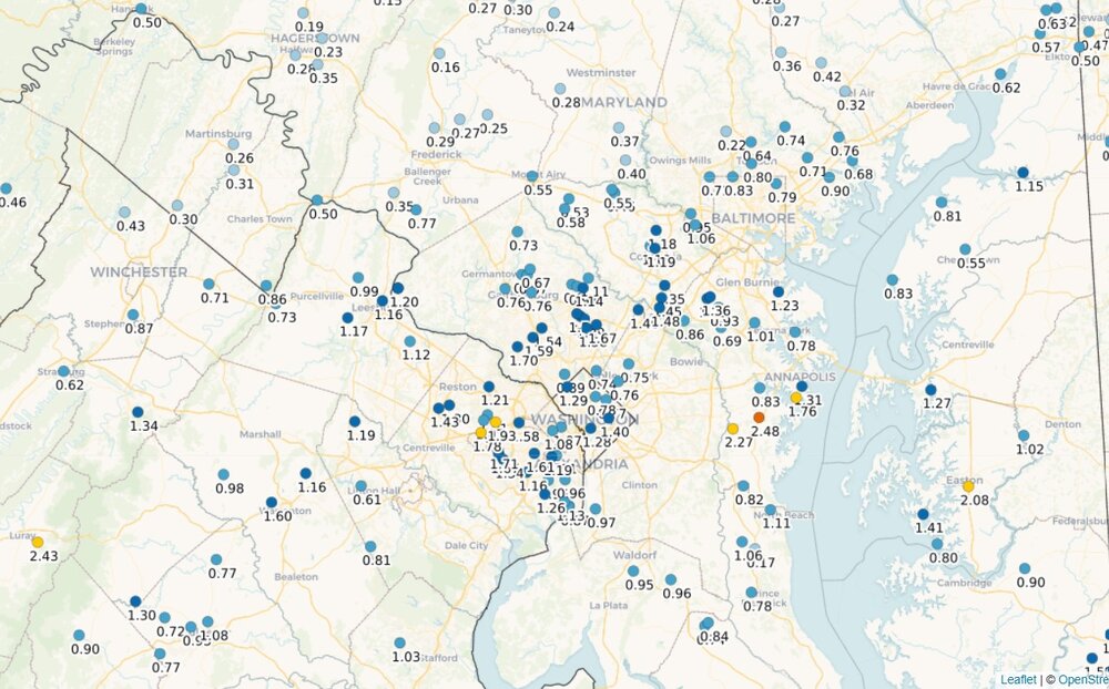
-
~1.5" across two days. DCA up to 1.31" for the month.
-
There’s a tiny stripe from Centerville to Tysons to Silver Spring that managed to get fringed both days.


