MN Transplant
-
Posts
17,845 -
Joined
-
Last visited
Content Type
Profiles
Blogs
Forums
American Weather
Media Demo
Store
Gallery
Everything posted by MN Transplant
-
I think it is simply some measure of gauge height. https://water.weather.gov/ahps2/hydrograph.php?wfo=lwx&gage=wllm2. The 48.6' from 1936 would have been ~46' above the level from today.
-
The Seasonal Snowfall Futility Markers
MN Transplant replied to North Balti Zen's topic in Mid Atlantic
There have only been 4 years that have been complete shutouts through January. 1889-90: 6.5" (5" in March) 1913-14: 28.6" (19" in March) 1959-60: 24.3" (17.1" in March) 1972-73: 0.1" Of course, every other year (n = 7) with less than 1" finished below 10" total. So, effectively two March stick saves in the 11 years that were duds through January. -
He balled out in clutch moments all year, but I wish he would have just chucked it up. The play call was baffling, though, with too many deep and shallow routes on a 4th and 8. In the end, we knew the downfall of the Vikings would be the terrible defense. 431 yards and 31 points to Daniel Jones. Kwesi is going to gut that side of the ball in the offseason, and hopefully Ed Donatell is first to go.
-
I always miss the good ones. (saw some flurries in Denver this week, and they do have old snow on the ground)
-
On pace for the warmest January on record, but holding something that beats +10.5 (1950) is a tall order.
-
I honestly have no idea what will happen, but the teams played a close game a few weeks ago and it’ll probably be the same. The Twins need to stay healthy. Last season was a disaster by midway thought the season.
-
Happy GB Packers Elimination Day!
-
32 right on at DCA. 29.5 is my current and low temp.
-
Only a +8 today at DCA. Really drags down the +16.5 through the first 6 days.
-
Here's a station closer to you that had the pressure fall. https://www.wunderground.com/dashboard/pws/KVAHERND44/graph/2022-01-16/2022-01-16/daily I actually lost power for a couple of hours that night. Here's the thread: My weather event of 2022 is the Jan. 3rd snowfall. 8.8". Just a nice snowfall with the Christmas lights still up. Saved the winter. Otherwise, the thunderstorms and heat were fairly tame. No big wind or rain (3"+) events. Perhaps the oddest event was the first week of October, where it just kept raining, with 6 straight days of measurable, and 4 straight days with over 1/3".
-
Quite the whiff on short range precip modeling today. Ended up with a T.
-
Record highs at all three airports today
-
The NFL is really in a pickle here. They could play the rest of the game tomorrow, but it just doesn’t seem right without better word about Hamlin. They could also just call off the game and go by win % for seeding, but that pretty much hands KC the 1 seed and gives Cincy the division. So, interesting question for Ravens fans, are you ok with the NFL cancelling the game and giving Cincy the division title?
-
Oh, NAM. 63.5 here
-
50s in the mountains and some 20s in the favored cool spots. DCA 33, IAD 28, and I’m 38 at 450’.
-
Yeah, 45 here. Upper 20s out by Culpeper. Wild temperature distribution.
-
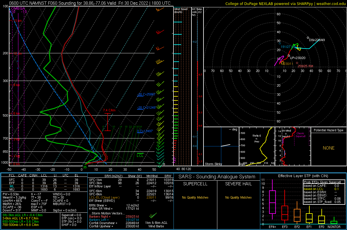
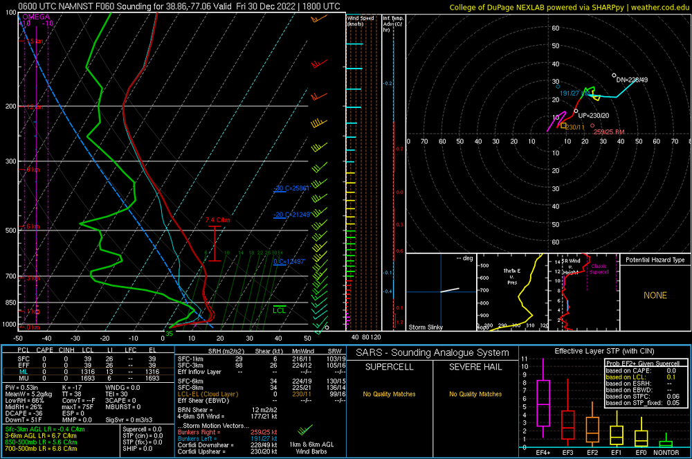
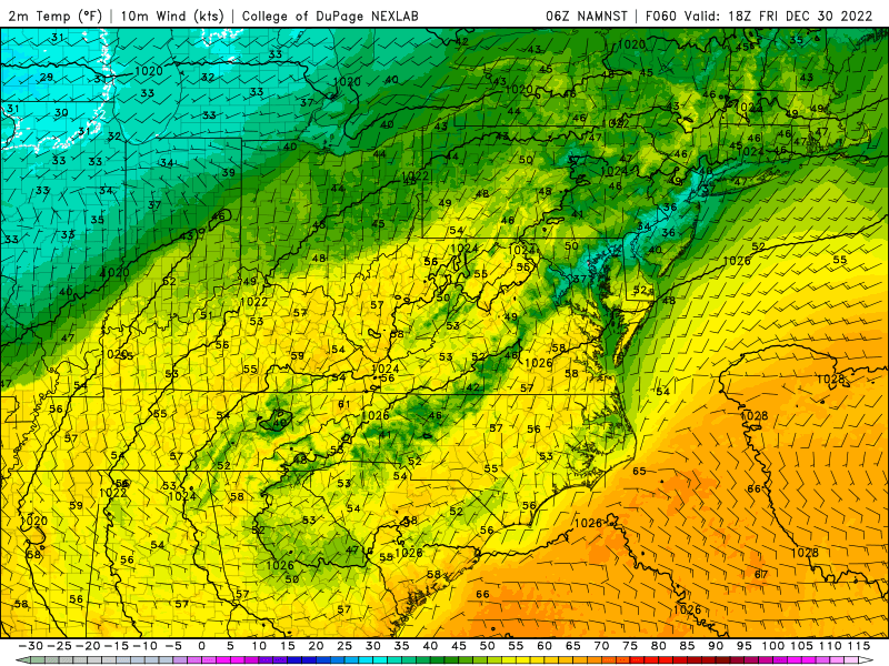
That certainly could be an explanation at first glance, but that wouldn't explain the overnight lows (image below). It is like the land surface scheme has a foot of snow over us instead of, well, nothing. And the HRRR is having none of it, with highs in the mid-upper 50s on Friday.
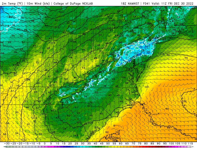
-
I'm not sure exactly what the NAM Nest is doing on Friday. Every other model has us in the 50s, but the NAM is throwing out this ridiculous inversion along 95.
-
I keep thinking back to this old Family Guy episode. Just switch the movie for this winter. Even the map reference is right on. [Brian, working as a Seeing Eye dog, sits beside his blind guy in a movie theater] Brian: Okay, they're-they're in the woods...the camera keeps on moving...Uh, I think they're, they're looking for some witch or something, I-I don't know, I wasn't listening...nothing's happening, nothing's happening, something about a map, nothing's happening, it's over, a lot of people in the audience on AMWX look pissed.
-
Here's a really boring stat comparing the 1980s to 2010s. Total snowfall of every day in the 1980s: 183.0" Total snowfall of every day in the 2010s: 155.7"
-
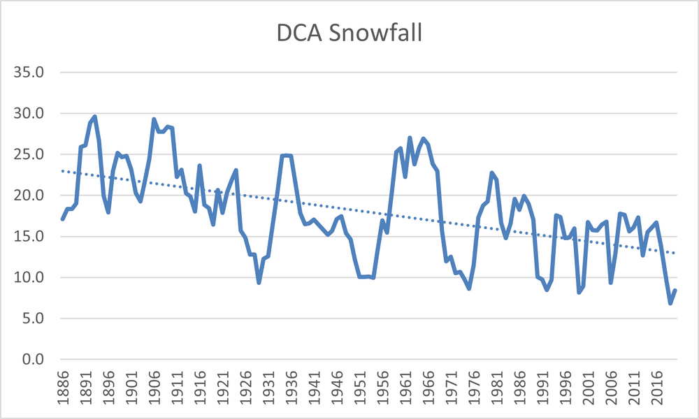
That's a bit of a disingenuous statement because we simply don't have full DC-area data for the entire 1880s. What I can say is that using the daily data, the average for the five-year period from 1885-1889 was 18.3". That is higher than any 5-year period in present day going back until 1988. The latest 5-year average is 8.4".
-
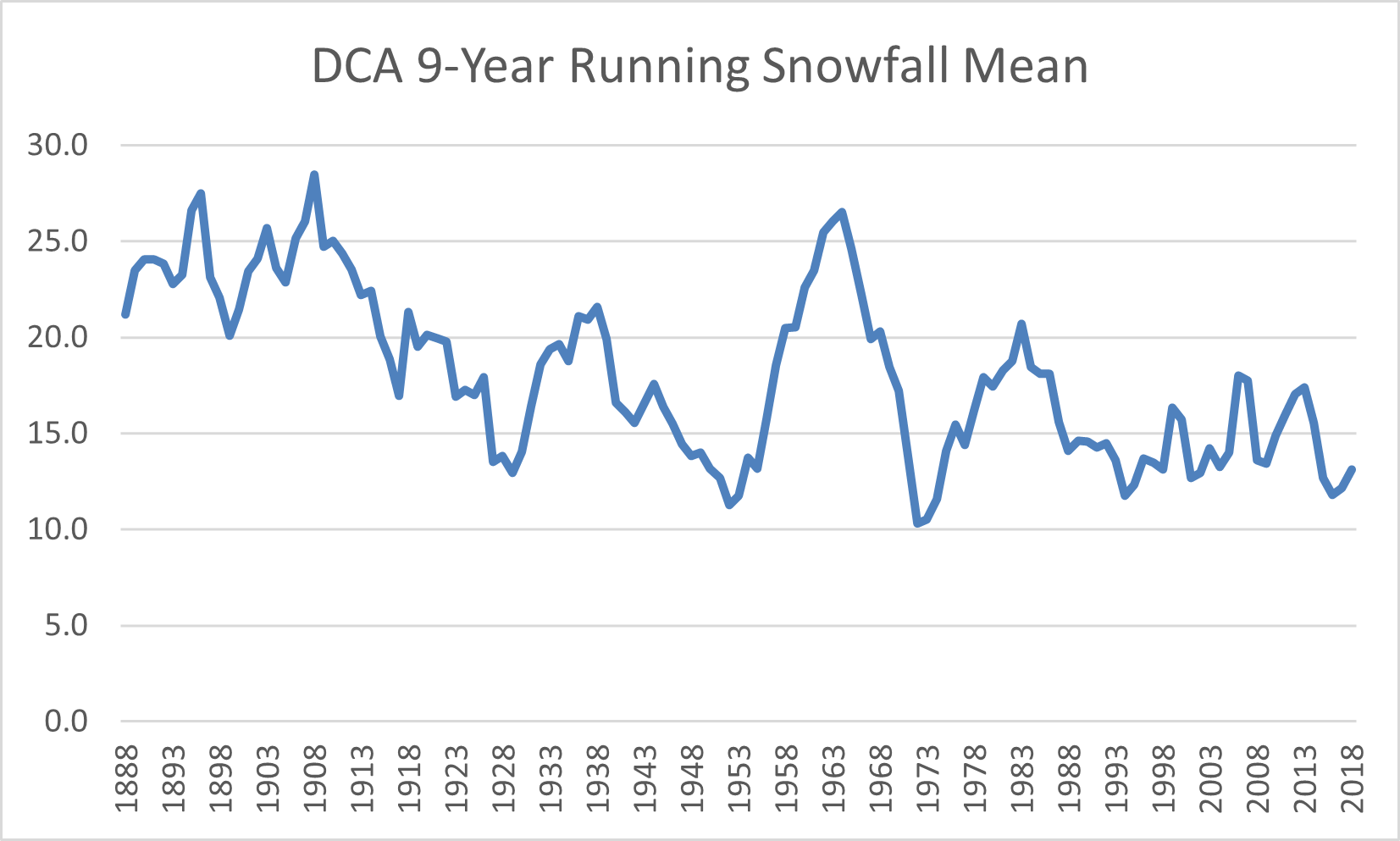
This chart might get to what WesternFringe is trying to say. If you take a centered 9 year running mean, the "worst" periods over that kind of timescale aren't getting worse. We are still pulling off enough of the 2003s, 2010s, 2014s and 2016s to balance it out.
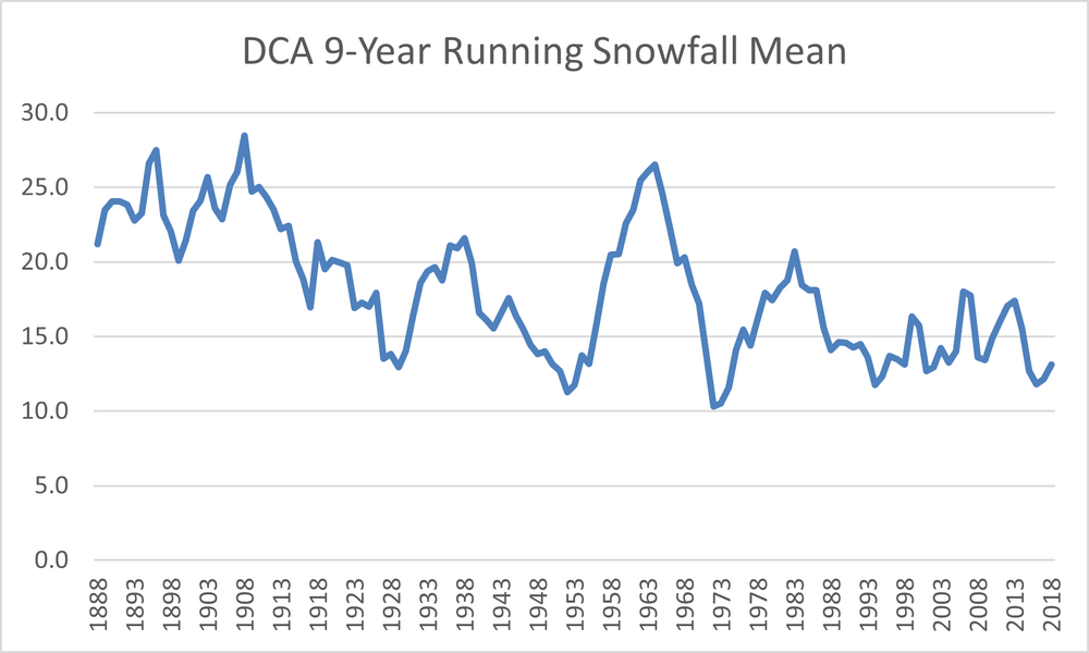
-
I'm confused. The 1960s were excellent for snowfall. Remember that these are calendar years, not winter. 1960 33.0 1961 34.1 1962 28.7 1963 11.6 1964 27.9 1965 16.6 1966 44.3 1967 34.2 1968 8.2 1969 15.9 2013 4.4 2014 30.5 2015 18.3 2016 22.2 2017 5.3 2018 7.3 2019 15.9 2020 0.2 2021 5.4 2022 13.2
-
About that Calendar Year Single digit snowfall years 1884-1918 4 1919-1953 7 1954-1988 9 1989-2022 16
-
I'll take the challenge. My choices would make a stats professor cringe, but they crudely get the point across. Using daily data from DCA (downloaded from the Utah St. site), I calculated calendar year snowfall totals. I know the monthly and winter totals are available at LWX's site, but the use of daily snowfall lets us look a little more in depth. We actually have 139 years of data, which divides nicely into 4 quartiles of 35, 35, 35, 34. Across the board, the stats have fallen off. Calendar Year Average Median Years w/4" days Years with 6" days 1884-1918 22.8 23.4 29 14 1919-1953 16.3 14.9 27 16 1954-1988 18.5 14.7 25 14 1989-2022 13.3 10.5 17 12 And if you take a 5-yr running mean, and apply a basic trendline to that, woof. The trend is less steep if you remove the pre-airport location data (~1950), but it is still there.