MN Transplant
-
Posts
17,811 -
Joined
-
Last visited
Content Type
Profiles
Blogs
Forums
American Weather
Media Demo
Store
Gallery
Everything posted by MN Transplant
-
2/22-23 "There's no way..." Storm Part 2
MN Transplant replied to Maestrobjwa's topic in Mid Atlantic
I bet those get bumped by about an inch by the end of the day. -
2/22-23 "There's no way..." Storm Part 2
MN Transplant replied to Maestrobjwa's topic in Mid Atlantic
Doing some estimation, it looks like 0.5"-0.6" for a lot of us, which is a nice result and lands in the middle of the more conservative models and the NAMs. -
2/22-23 "There's no way..." Storm Part 2
MN Transplant replied to Maestrobjwa's topic in Mid Atlantic
You need to look at the forecast overnight. Tomorrow daytime is not relevant unless you are a true GFS believer. -
2/22-23 "There's no way..." Storm Part 2
MN Transplant replied to Maestrobjwa's topic in Mid Atlantic
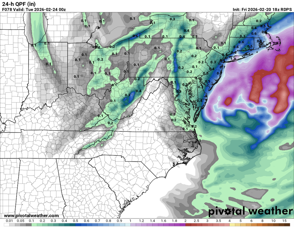
RDPS (RGEM) similar, maybe 0.3"-0.4" in that timeframe, with the exception of the inverted trough which remains from Leesburg to Hagerstown. -
2/22-23 "There's no way..." Storm Part 2
MN Transplant replied to Maestrobjwa's topic in Mid Atlantic
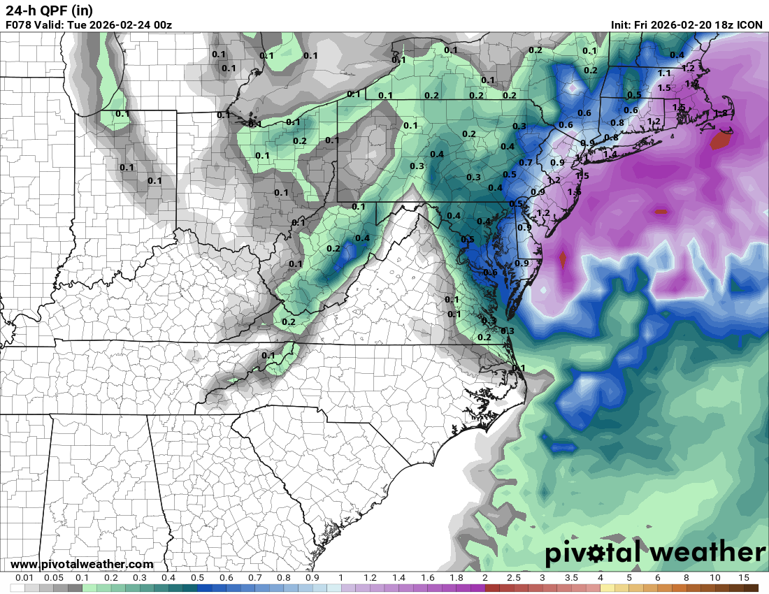
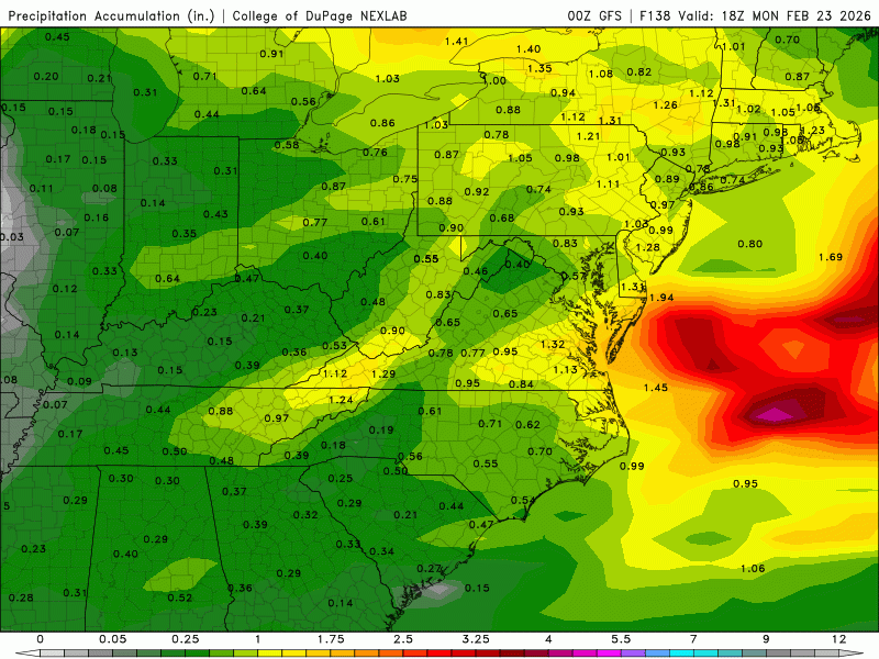
ICON looks fine. Ignore the snow maps, they are irrelevant. 0.3" precip falls in DC-Balt after 00z, and if we are taking 22z to be the changeover, there's likely another 0.1" added to that (I only have the 6-hr increments on Pivotal). So, that puts it in the 0.4" of snow QPF camp. -
2/22-23 "There's no way..." Storm Part 2
MN Transplant replied to Maestrobjwa's topic in Mid Atlantic
The 3km is a really nice run. It has the 5-9pm period as a key for solid snow, but it also throws back more precip overnight, especially closer to the Bay. Verbatim, there is 0.65" of precip after 5pm in DC and nearly 0.9" in Baltimore. -
2/22-23 "There's no way..." Storm Part 2
MN Transplant replied to Maestrobjwa's topic in Mid Atlantic
HRRR is ~0.2-0.4" QPF after 5pm. That's our event. -
2/22-23 "There's no way..." Storm Part 2
MN Transplant replied to Maestrobjwa's topic in Mid Atlantic
On one level, this is a mess of a forecast because the models are all over the place. On another, this is really just a straightforward event where we lean on climo. It isn't going to accumulate during the day in the metro areas and while the precip blossoms again with the low cranking, the broader shield isn't going to be particularly heavy. 2-4" should cover it for most of us, with less in the unfortunate areas on the tarmac at DCA, and more in the hills. -
2/22-23 "There's no way..." Storm Part 2
MN Transplant replied to Maestrobjwa's topic in Mid Atlantic
Don’t worry, when we have 4” of slop while the rest of the NE corridor is buried, you’ll feel at ease. -
The February 22-23 Late Season Miracle: JV Disco/Banter Thread
MN Transplant replied to bncho's topic in Mid Atlantic
It’s nice how everyone is getting pumped for a PHL/NYC/BOS storm. -
2/22-23 "There's no way..." Storm Part 2
MN Transplant replied to Maestrobjwa's topic in Mid Atlantic
The HRRR is a believable scenario. Comes in with a good slug of early moisture, lulls midday, and then ramps back up and cools down late afternoon into evening. -
2/22-23 "There's no way..." Storm Part 2
MN Transplant replied to Maestrobjwa's topic in Mid Atlantic
-
2/22-23 "There's no way..." Storm Part 2
MN Transplant replied to Maestrobjwa's topic in Mid Atlantic
Not even the GFS is doing what the GFS was doing. Those 3-4" QPF runs were pure fantasy. -
2/22-23 "There's no way..." Storm Part 2
MN Transplant replied to Maestrobjwa's topic in Mid Atlantic
Sticking with the solution. If it goes down, it is going down swinging. -
2/22-23 "There's no way..." Storm Part 2
MN Transplant replied to Maestrobjwa's topic in Mid Atlantic
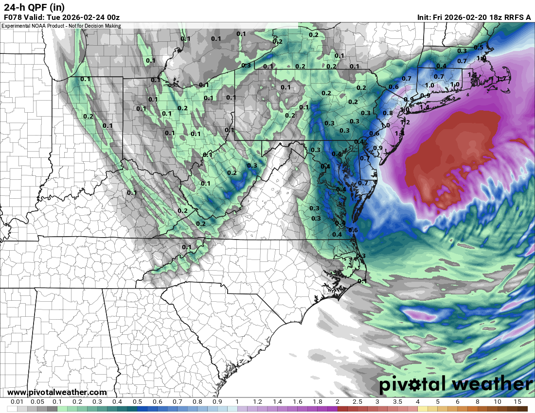
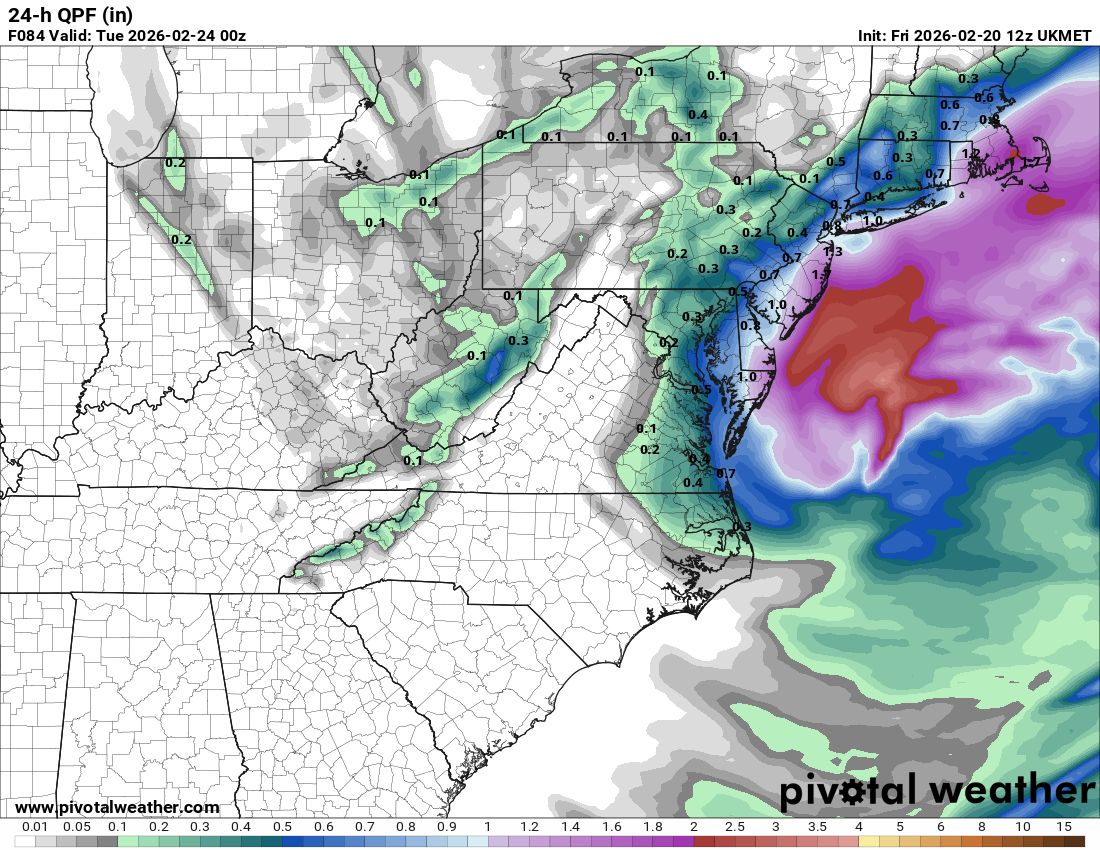
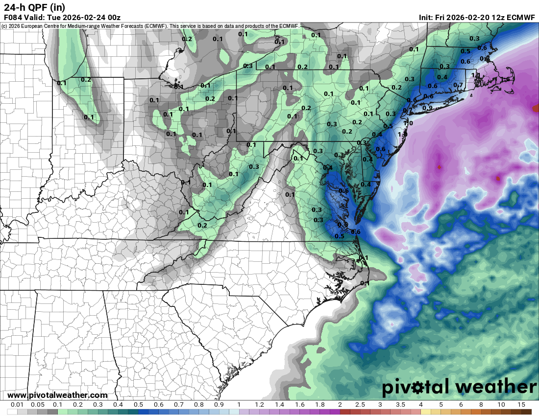
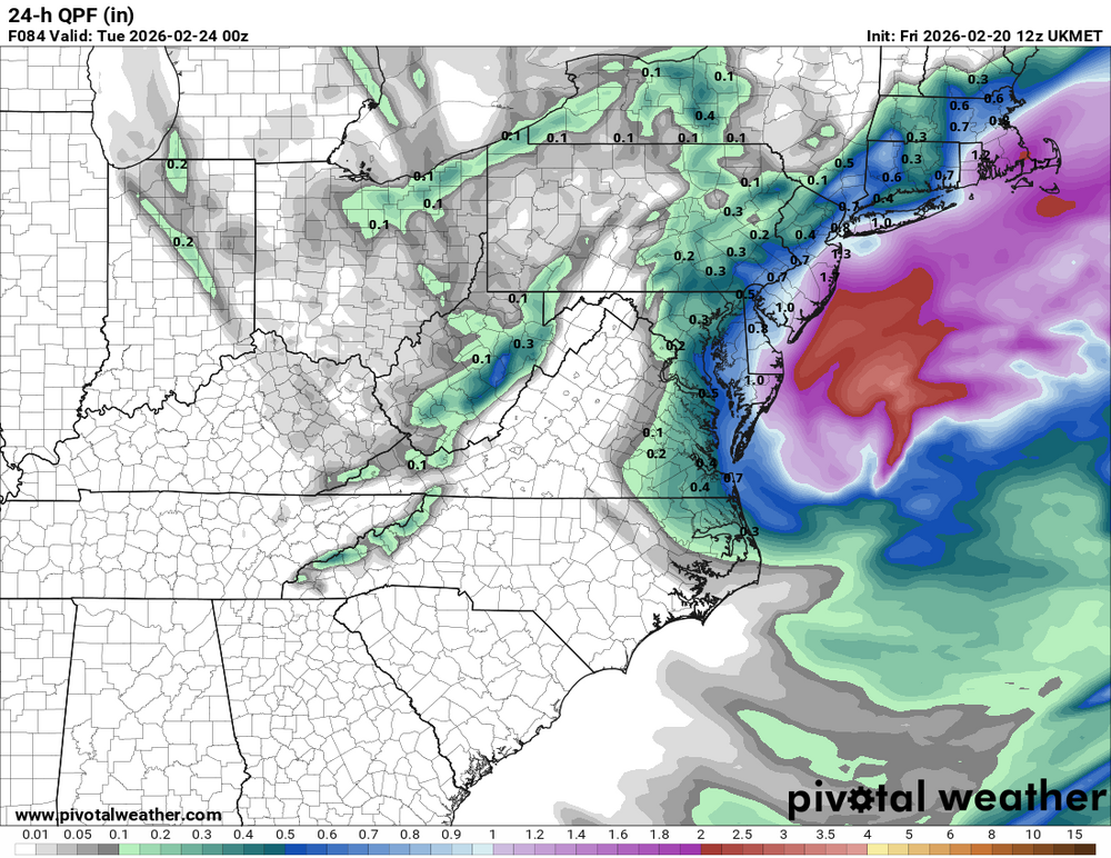
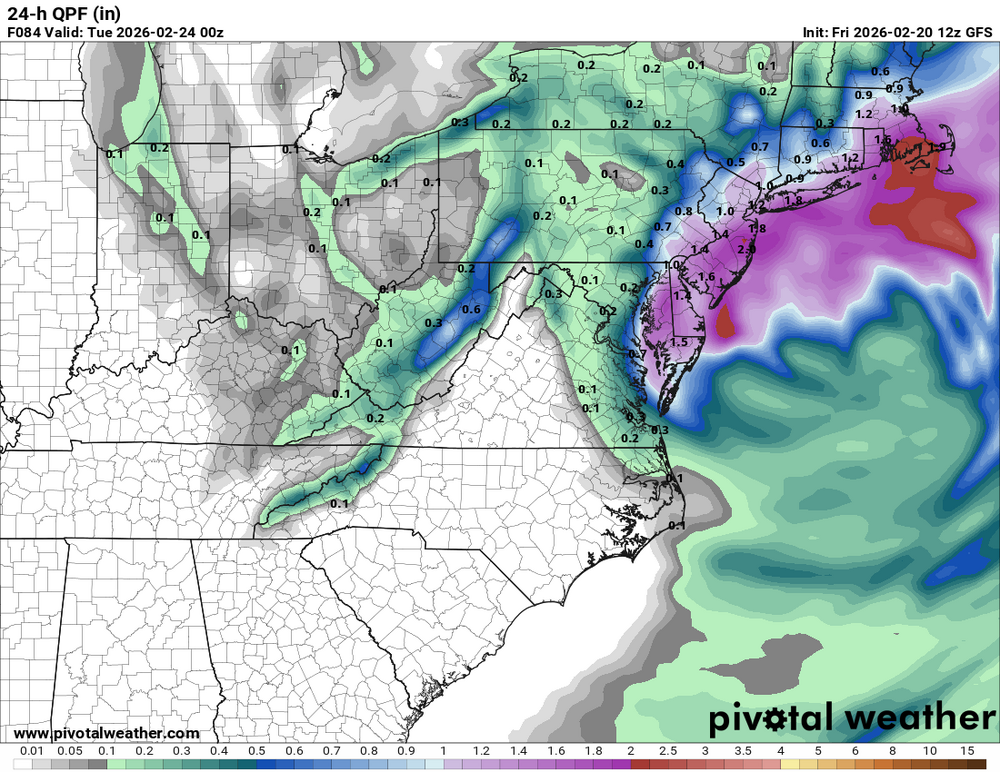
Trying this again. 18z except for the UKMET/GFS/Euro. Precip that falls after 00z (Sunday 7pm) which should be able to accumulate outside of the favored areas.

-
2/22-23 "There's no way..." Storm Part 2
MN Transplant replied to Maestrobjwa's topic in Mid Atlantic
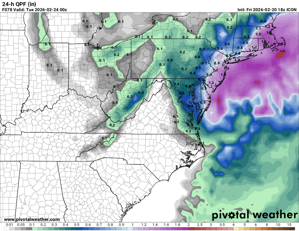
ICON is 0.4-0.5" QPF after 00z Monday from Frederick/Loudoun/Fairfax and east. -
2/22-23 "There's no way..." Storm Part 2
MN Transplant replied to Maestrobjwa's topic in Mid Atlantic
The Nest has half the precipitation as the parent through 60 hours. On some areas of the DelMarVa it is 1/3. My assumption is that nothing that falls before 21z will accumulate, and then we get the trough action. -
2/22-23 "There's no way..." Storm Part 2
MN Transplant replied to Maestrobjwa's topic in Mid Atlantic
I understand why we are ignoring it, but the NAM 3km is a torch at the surface. Still 37/38 by late afternoon Sunday. -
Feb 22nd/23rd "There's no way..." Storm Thread
MN Transplant replied to Maestrobjwa's topic in Mid Atlantic
Pretty sure everyone here is using IVT wrong. I also know it as you stated, but I think people here are using it as shorthand for inverted trough. -
Feb 22nd/23rd "There's no way..." Storm Thread
MN Transplant replied to Maestrobjwa's topic in Mid Atlantic
That was the most exaggerated difference between my house and downtown. Seeing Cantore on the mall with nothing and 4" of absolute paste in my yard was unreal. -
Feb 22nd/23rd "There's no way..." Storm Thread
MN Transplant replied to Maestrobjwa's topic in Mid Atlantic
I had 4"+ of snow from both March 2013 storms and neither dropped below 33 degrees. -
Feb 22nd/23rd "There's no way..." Storm Thread
MN Transplant replied to Maestrobjwa's topic in Mid Atlantic
34/34 at 00z Monday with snow falling. It would accumulate, but... -
Feb 22nd/23rd "There's no way..." Storm Thread
MN Transplant replied to Maestrobjwa's topic in Mid Atlantic
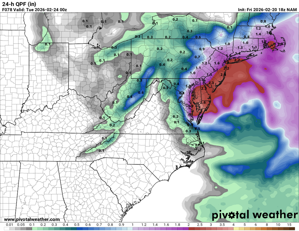
Precip at DC by 18z Sunday: 3km NAM 0.02" Parent NAM 0.13" RGEM 0.28" GFS 0.90" Euro (06z) 0.08" One of these things is not like the other. -
Feb 22nd/23rd "There's no way..." Storm Thread
MN Transplant replied to Maestrobjwa's topic in Mid Atlantic
Normally we should be banning Kucera maps, this time around we should be banning 10:1 maps. -
Feb 22nd/23rd "There's no way..." Storm Thread
MN Transplant replied to Maestrobjwa's topic in Mid Atlantic
Pretty similar result, bullseye is still east of the Bay but it is largely a hit.