crossbowftw3
-
Posts
1,394 -
Joined
-
Last visited
Content Type
Profiles
Blogs
Forums
American Weather
Media Demo
Store
Gallery
Everything posted by crossbowftw3
-
Gonna say that it should've probably been in place from the beginning. Same with the HWWs from Central LI east
-
Odd to see this late in the year but not unprecedented. Most everything should shut off within the 3 hour window after sunset so if we see convection it should be firing up by 2-3 PM.
- 212 replies
-
- 1
-

-
- wind damage
- heavy rain
- (and 1 more)
-
Meanwhile in the Catskills wind beginning pick up now and should be strongest for the next 3-5 hours, gusts between 25-35 still seem reasonable if anything mixes down, shifting east quickly. then thereafter watching for any convection but chances seem kinda questionable with the stable layer existing. I like CNJ and points northeast of there for actual convective chances. Surprised SPC didn't expand slight risk to at least coastal areas. @wdrag what are the odds this far N&W of the city sees anything convection wise, still decent?
-
Weak instability overall but quite good shear. Gonna be interesting to see what might fire up later since a dry slot is coming in rather quick. Should shut the rain down and increase chances for some storms.
- 212 replies
-
- 2
-
-

-
- wind damage
- heavy rain
- (and 1 more)
-
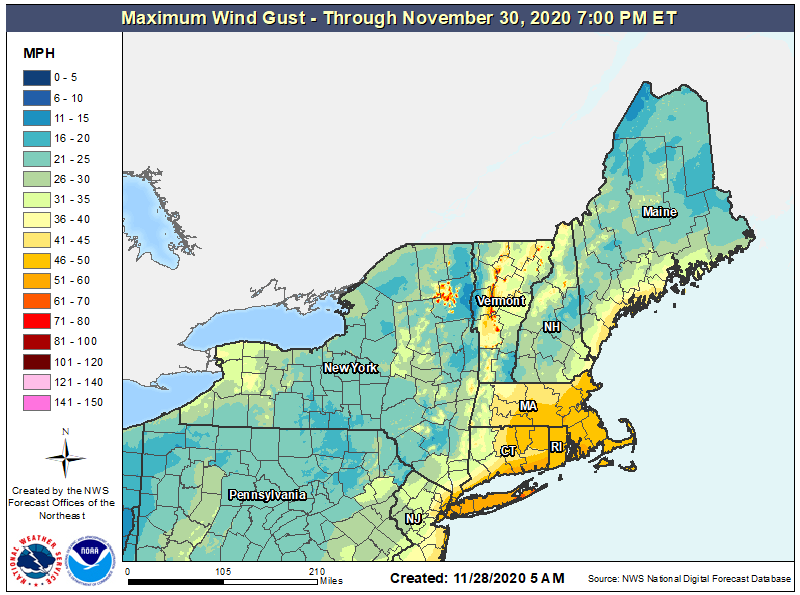
Pretty interesting to see. Accordingly BOX did hoist high wind watches. I would suspect advisories by Upton by later today. Here inland from the city I still expect only 20-30 gusts with maybe 30-40 in elevations. Current point and click has winds sustained 10-15 with gusts to 25 at my house at 750' which seems reasonable. Still have the fairly obvious inversion in soundings.
- 212 replies
-
- 1
-
-
- wind damage
- heavy rain
- (and 1 more)
-
Walt, Any idea on why western areas aren't exactly looking to get in on these big winds? I assume inversions in the soundings? This is the latest GIS gust map.
-
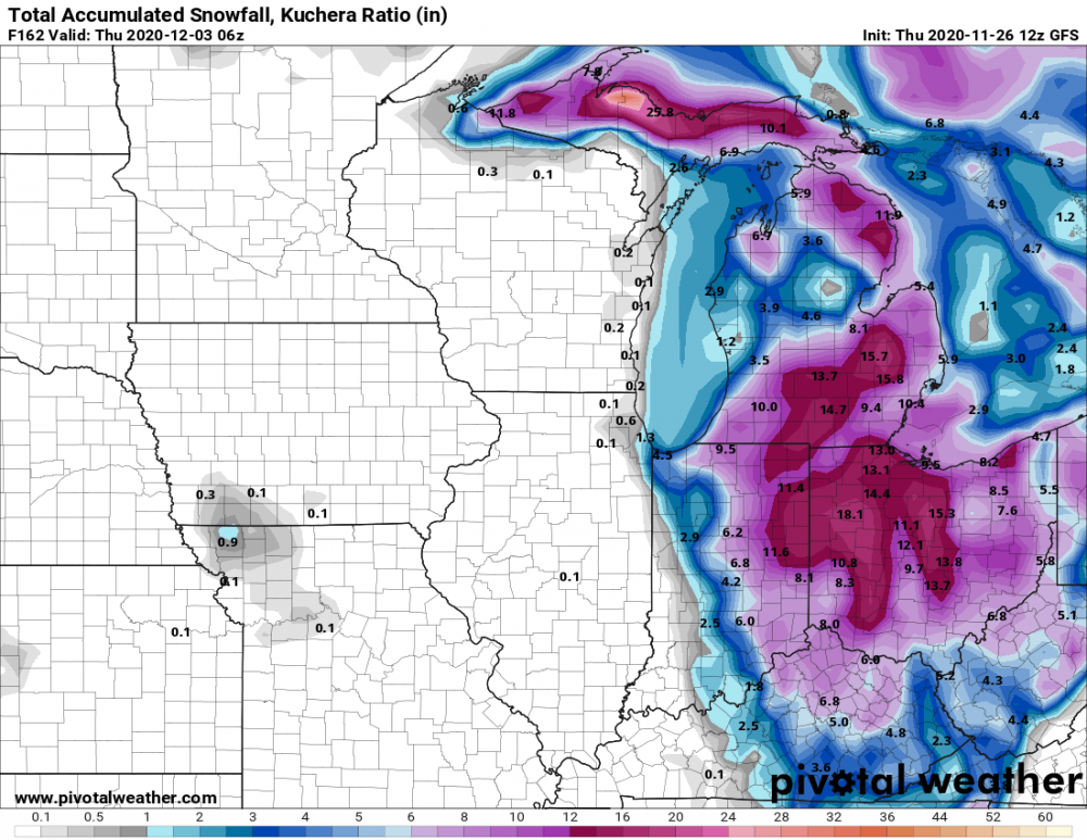
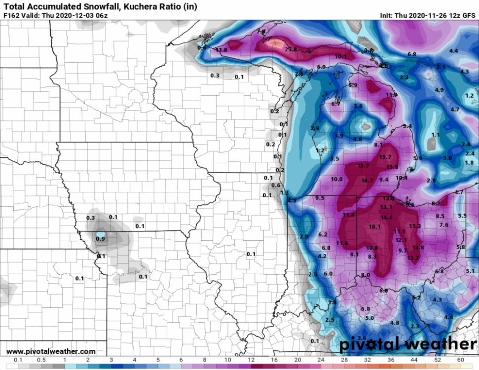
Latest GFS. You could in theory drive from Chicago to Cleveland and go from nothing to well over a foot.
-
Gonna be interesting to watch what happens in Ohio/Indiana. Potential very sharp snow gradient might be in play....talking nothing to at least a foot within maybe 30 miles. If not less, that is.
-
Plausible knowing that every so often the southern states (mainly NC) get a snowstorm, with results never really pretty.
-
Wouldn't shock me knowing that every year or so the south always gets a storm or two in December-January. The results never tend to be pretty.
-
Line just blew through here in the Catskills. I say "Blasted" because the gusts lasted for all of four or so minutes. From my eye test we probably gusted to about 40 or so here. Line already gone, but under a severe warning which is kinda redundant at least in my immediate location. Good luck to everyone here.
-
Checking in from the Catskills. The line blasted through just a bit ago while still not entirely organized. From my eye test I would guess we had gusts around 40-45 for about 2 minutes or so. This line is quickly becoming organized so I suspect an increase severe reports should quickly occur to my east. Good luck everyone on this forum. Under a severe warning but that's kinda redundant with the line already gone and just stratiform rain falling.
-
Upstate/Eastern New York
crossbowftw3 replied to BuffaloWeather's topic in Upstate New York/Pennsylvania
If the front were timed just a bit better I think a more widespread wind event would have been at hand. Here downstate frontal arrival will still be timed far after sunset and without better mixing. Guessing better gust potential here should be with the line itself. Still like the idea of gusts 25-35 here downstate. -
Upstate/Eastern New York
crossbowftw3 replied to BuffaloWeather's topic in Upstate New York/Pennsylvania
Here downstate there doesn't look to be nearly enough mixing to produce gusts close to advisory range but 25-35 looks most reasonable -
Sticking only to colder surfaces and probably not much more with temperatures still at 35-36 and the precipitation ending here by around 10.
-
remnants of zeta and potential first flakes for some areas
crossbowftw3 replied to forkyfork's topic in New York City Metro
Completed the flip here at 800' in the Catskills, still won't get more than maybe a C-1". New England is looking incredibly good for 3-6" right now. -
Has now completely flipped here in the lower elevations of the Catskills as well. Not much will happen here now but it's all swinging your way.
-
Upstate/Eastern New York
crossbowftw3 replied to BuffaloWeather's topic in Upstate New York/Pennsylvania
Getting ever more closer to the flip now, but again simply too little too late with the back end of the shield booking it ever more faster. Now only 60-70 miles away. Edit: now have pretty much completely flipped. -
Upstate/Eastern New York
crossbowftw3 replied to BuffaloWeather's topic in Upstate New York/Pennsylvania
With it getting light out I'm definitely seeing flakes but still mixed with the rain, 36 degrees. looking a bit too late now. -
Upstate/Eastern New York
crossbowftw3 replied to BuffaloWeather's topic in Upstate New York/Pennsylvania
Now down to 37 but still rain. Could be close now but the end of the precipitation shield is now only 90 miles away. -
Upstate/Eastern New York
crossbowftw3 replied to BuffaloWeather's topic in Upstate New York/Pennsylvania
Just as fast it went back to all rain still holding at 39. Relay beginning to believe that folks in MA/CT are gonna get caught off guard as all 6z models are beginning to imply 3-6" that way now -
Upstate/Eastern New York
crossbowftw3 replied to BuffaloWeather's topic in Upstate New York/Pennsylvania
TWC point forecast implies rain and snow but hard to see flakes right now. Still surely rain dominant at still 39 degrees -
Upstate/Eastern New York
crossbowftw3 replied to BuffaloWeather's topic in Upstate New York/Pennsylvania
Back end of the shield is crossing Elmira now, probably have another 4-5 hours of this left to get flakes -
At lower elevations here in the Catskills I only just dropped below 40F but there's signs that you folks in New England are gonna win this one