

crossbowftw3
-
Posts
1,394 -
Joined
-
Last visited
Content Type
Profiles
Blogs
Forums
American Weather
Media Demo
Store
Gallery
Everything posted by crossbowftw3
-
Upstate/Eastern New York
crossbowftw3 replied to BuffaloWeather's topic in Upstate New York/Pennsylvania
Looks like my switch could commence later next week. 10 day forecast slowly surges us up until we hit near-70 by next Saturday and only goes up from there. -
Upstate/Eastern New York
crossbowftw3 replied to BuffaloWeather's topic in Upstate New York/Pennsylvania
Hoping for the best with the squalls. Regardless by Memorial Day we'll all be installing our Air Conditioners and this'll be but a passing memory in the wind as we roast in 80 degree/65+ dew point heat -
Upstate/Eastern New York
crossbowftw3 replied to BuffaloWeather's topic in Upstate New York/Pennsylvania
Pretty much praying for an inch now but tomorrow's squalls look more juicy anyway. Gonna feel like a mid winter day even in between the possible squalls. Hoping whoever has to go on the roads are ready for them. -
Upstate/Eastern New York
crossbowftw3 replied to BuffaloWeather's topic in Upstate New York/Pennsylvania
Still count on a burst of snow but the writing on the wall was pretty evident -
Upstate/Eastern New York
crossbowftw3 replied to BuffaloWeather's topic in Upstate New York/Pennsylvania
18z Euro is (probably) the final nail in the coffin.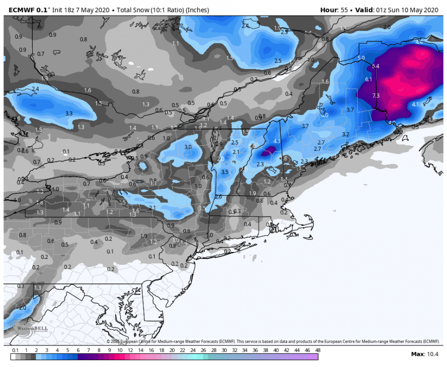
-
Upstate/Eastern New York
crossbowftw3 replied to BuffaloWeather's topic in Upstate New York/Pennsylvania
Overall though the models are slowly moving away from a more widespread heavier snow which makes sense. still not counting on much more than a 1-3/3-5 deal, yet that doesn't matter as it'll for certain be the latest I've seen snow on record. -
MSV finished more than twice below norms for snow by comparison. In some aspects 2011-12 was worse but in others this past winter takes the cake.
-
Pretty much. One last act of defiance from old man winter in the winter that both never wanted to start then never wanted to end
-
My thoughts exact which makes the NAM seem like its off its rocker
-
NAM seems to still be well out to lunch here. Thinking something not too dissimilar from a blend of everything would make sense here. Which means uh...2-4? Still ridiculous for time of year.
-
Upstate/Eastern New York
crossbowftw3 replied to BuffaloWeather's topic in Upstate New York/Pennsylvania
It'll be incredibly eye opening if I wake up to a white ground Saturday. I think north of me and closer to BGM is likely where you move past in air and into accumulations. Razor thin line between accumulations and nothing. -
Upstate/Eastern New York
crossbowftw3 replied to BuffaloWeather's topic in Upstate New York/Pennsylvania
At my elevation not counting for more than 2", considering....but holy cow, never did I expect to be facing snow this late. I thought the snow from the 19th last month was absurd. -
Straddling the PA border in Sullivan County and thus far nothing is sticking. I envision by sunset things will begin to stick. Looking for 2-4 before the warm air punches in and causes us to mix sometime after midnight.
-
Same boat here. Just a few counties northeast of the watch and we've never gained much opportunity to destabilize. Sure it was pretty windy this morning but it's slowed since. No signs of clearing, but if we do there'll be little to no time to effectively destabilize before the line pushes through.
-
Guessing I'm basically in the middle on this one (away from the LLJ, away from the low track) so I'm thinking only really 40-50 with 50+ at elevations for a wide area that is in between these two features. Anyone think the same?
-
It is. coincidentally on the same date as Lee County from last year.
-
No longer waiting for Cookeville. EF4 with winds of 175.
-
Hearing from other forums that Tennessee EMA Spokesperson now indicating at least 28 deaths, 200+ injured.

