crossbowftw3
-
Posts
1,394 -
Joined
-
Last visited
Content Type
Profiles
Blogs
Forums
American Weather
Media Demo
Store
Gallery
Everything posted by crossbowftw3
-
Upstate/Eastern New York
crossbowftw3 replied to BuffaloWeather's topic in Upstate New York/Pennsylvania
Waking up to discover I have not dropped below 40 degrees at all. Running out of time for anything great but still rooting for flakes. The precip is leggimg it all the way. New England is looking ever the more better now Edit: well, 39 now. But since Temps will not get close to freezing not a ton of snow (if any) will succeed in sticking. -
Upstate/Eastern New York
crossbowftw3 replied to BuffaloWeather's topic in Upstate New York/Pennsylvania
definitely gonna need the rates to be good enough to get the accumulations on the cooler surfaces/grasses especially as the transition will likely not happen here until close to sunrise -
Upstate/Eastern New York
crossbowftw3 replied to BuffaloWeather's topic in Upstate New York/Pennsylvania
Still gonna root for 1-2" here at 800' but coating still works. If this were a month later a decent snowstorm would be just getting underway. Expecting to hear up to low advisory amounts at elevations still. -
remnants of zeta and potential first flakes for some areas
crossbowftw3 replied to forkyfork's topic in New York City Metro
From the records I've been able to find the western side still experienced Tropical Storm force winds. -
remnants of zeta and potential first flakes for some areas
crossbowftw3 replied to forkyfork's topic in New York City Metro
Dry slot closing in now, I can probably see a few hours of drizzle or even just straight up dry weather up here but I'm seeing returns coming into WPA from the trough now. -
remnants of zeta and potential first flakes for some areas
crossbowftw3 replied to forkyfork's topic in New York City Metro
Yeah that still sound highly reasonable. Zeta now moving at 55 MPH, the dry slot is punching in rather fast. -
remnants of zeta and potential first flakes for some areas
crossbowftw3 replied to forkyfork's topic in New York City Metro
Of course the 53 MPH forward speed isn't even close to being a record, as the LI express hurricane is believed to have been moving between 60 and 70. Nonetheless the dry slot will punch in and shut down most of the precip until that second low rolls in, with the precipitation likely all but over by sunrise-10 AM or so tomorrow. Interesting trends for New England though, as advisory snows might be looking likelier there now. -
remnants of zeta and potential first flakes for some areas
crossbowftw3 replied to forkyfork's topic in New York City Metro
This thing is moving fast--up to 53 MPH now. Would not be shocked if the remnant rains are largely over by 8-10 PM tonight -
remnants of zeta and potential first flakes for some areas
crossbowftw3 replied to forkyfork's topic in New York City Metro
Better for elevations and maybe I can sneak in 1-2 inches? Would be good -
Upstate/Eastern New York
crossbowftw3 replied to BuffaloWeather's topic in Upstate New York/Pennsylvania
I almost let myself get head faked by what was actually the 6z Tuesday run of the Para but you still have a shot at good snows from this. It was never meant to be for MBY though for anything over a few inches. -
remnants of zeta and potential first flakes for some areas
crossbowftw3 replied to forkyfork's topic in New York City Metro
If the surprise is advisory snows that's cool with me, might dry out just too quickly for anything meaningful -
Either way here in lower elevations of the Catskills I'm pretty much cooked. First meaningful snow should happen by the end of next month so I'm not as upset
-
remnants of zeta and potential first flakes for some areas
crossbowftw3 replied to forkyfork's topic in New York City Metro
Looks even less likely now. Flakes are still a solid bet but meaningful accumulations are probably all but done at this rate save the elevations. Biggest concern turns into the 1-2" of rain followed right up with a freeze Friday afternoon into the evening: gonna be a problem on the roads I'm sure.
-
remnants of zeta and potential first flakes for some areas
crossbowftw3 replied to forkyfork's topic in New York City Metro
In the lower elevations of the Catskills I can't bargain myself seeing more than maybe a few slushy inches before things end Friday morning. Nonetheless flakes are a win this early on, solid advisory event setting up for elevations -
Meanwhile here in the lower elevations of the Catskills I can't bargain anything more than maybe a few slushy inches before the precipitation stops Friday morning. Oh well, early season gonna early season. It'll be our turn before long
-
Upstate/Eastern New York
crossbowftw3 replied to BuffaloWeather's topic in Upstate New York/Pennsylvania
Regardless flakes is a win this early on in the season. Typical early season setup will do as it typically does here I think and BGM is doing well to paint the picture. We will all get ours soon. -
Upstate/Eastern New York
crossbowftw3 replied to BuffaloWeather's topic in Upstate New York/Pennsylvania
Gonna get skunked at only 800' here in SW Sullivan. Maybe I'll find some cams and watch the snow Friday morning....and cherish the maybe coating that I get here. -
Upstate/Eastern New York
crossbowftw3 replied to BuffaloWeather's topic in Upstate New York/Pennsylvania
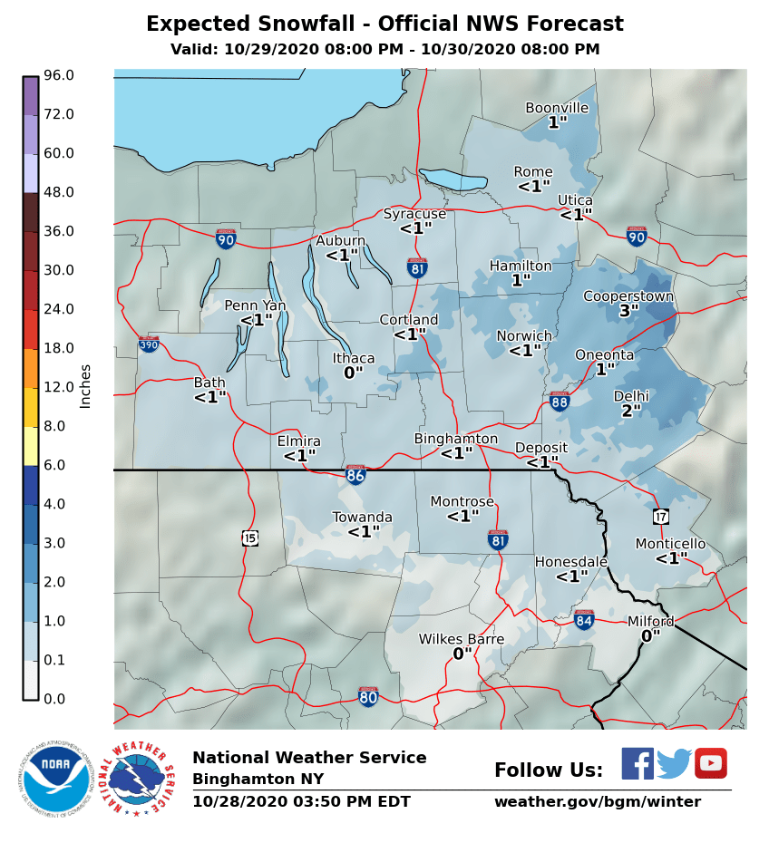
Here we go again. At 700' in Sullivan County I'm not gonna count on much of any here, but I can reasonably assume we will see some flakes here. Elevation is key for early season events, might apply once again here. @sferic Your house in Liberty might be good for up to 3" as I understand things now -
And with that said, if by some astrological odds Teddy gets hooked into NE/Atlantic Canada the most direct impacts would likely be confined there, with most west of inland Massachusetts probably not seeing much impact...even still gusty winds seem probable knowing the likely ET transition Teddy will undergo by the time it comes ashore at cat 2 equivalent. And marine impacts as well, of course.
-
I would assume by that point it is undergoing ET transition which could exacerbate things.
-
There's been six known instances of max wind potential (105 MPH gusts) in any watch, most recent was just last year across Minnesota and Northern Wisconsin
-
1630 outlook further expands the moderate risk into NW Wisconsin, with rather concerning wording at hand. 7000 SBCAPE pooling in SE ND already. https://www.spc.noaa.gov/products/outlook/day1otlk.html
-
2020 Mid-Atlantic Severe Weather - General Thread
crossbowftw3 replied to Kmlwx's topic in Mid Atlantic
6/3/14 for wind, hail cannot go past moderate. most recent PDS severe watch happened August last year. -
2020 Mid-Atlantic Severe Weather - General Thread
crossbowftw3 replied to Kmlwx's topic in Mid Atlantic
The case of lower Michigan might be one where a PDS severe watch is warranted only if the tornado threat was slightly lower. It's still entirely plausible under current circumstances, however. For us further east folk it looks like limited forcing today. -
It is. coincidentally on the same date as Lee County from last year.