

crossbowftw3
-
Posts
1,394 -
Joined
-
Last visited
Content Type
Profiles
Blogs
Forums
American Weather
Media Demo
Store
Gallery
Everything posted by crossbowftw3
-
Upstate/Eastern New York
crossbowftw3 replied to BuffaloWeather's topic in Upstate New York/Pennsylvania
GFS with a big time hit in the cities -
Upstate/Eastern New York
crossbowftw3 replied to BuffaloWeather's topic in Upstate New York/Pennsylvania
Right on the dotted line -
Upstate/Eastern New York
crossbowftw3 replied to BuffaloWeather's topic in Upstate New York/Pennsylvania
Right in the middle of the action with that ICON run. -
Active mid December with multiple event potential
crossbowftw3 replied to Typhoon Tip's topic in New England
NSFW warnings should be applied to this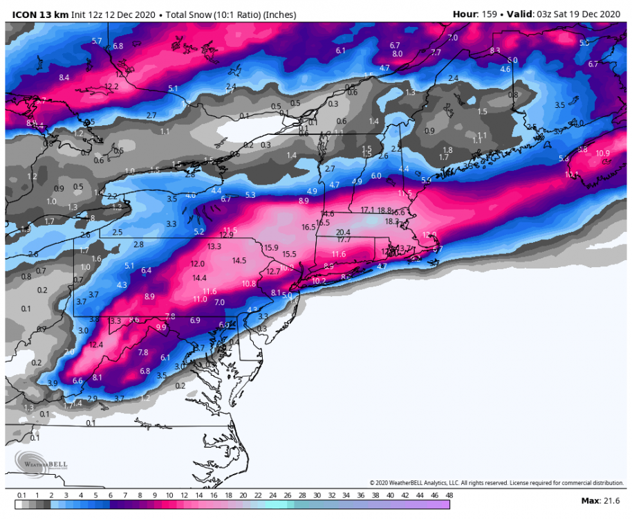
-
Maybe. But here inland we will likely be in the better spot....but we need to wait for the wave to get properly sampled before either camp can say for sure what will happen.
- 3,762 replies
-
- 1
-

-
- heavy snow
- heavy rain
- (and 3 more)
-
Upstate/Eastern New York
crossbowftw3 replied to BuffaloWeather's topic in Upstate New York/Pennsylvania
I'd think localized totals approaching 2 feet aren't out of the question...but they'd be exceptions, not the norm. Entirely plausible to get numerous/more widespread reports of one foot+ totals...or at least double digits -
Feeling a bit nervous being 100 miles inland in Sullivan, still like what I'm seeing but undoubtedly need to wait for the wave to be properly sampled
-
Upstate/Eastern New York
crossbowftw3 replied to BuffaloWeather's topic in Upstate New York/Pennsylvania
And to this extent my earliest best reasonable guess is a widespread 6-10+ storm...to a point. it'll be in Wednesday out Thursday. The 20"+ runs seem unlikely unless the storm sits and just parks for a time. It'll be cold too, ratios likely 15:1 or thereabout. No concern for mixing with temperatures likely hovering in the mid 20s by day, going to mid teens by night. Better picture of the situation will start happening by tomorrow. -
Upstate/Eastern New York
crossbowftw3 replied to BuffaloWeather's topic in Upstate New York/Pennsylvania
Very good point. Like where I am right now but we are still a day away from having the wave that will become the catalyst for this storm able to be properly sampled -
Upstate/Eastern New York
crossbowftw3 replied to BuffaloWeather's topic in Upstate New York/Pennsylvania
Even here in Sullivan I do get the sneaking feeling this could evolve to give NYC more snow than we will have here. We will have higher ratios here (I'm thinking 15:1 based on the words of Walt Drag), mind you -
Member 1 looks kinda odd compared to the rest
-
Upstate/Eastern New York
crossbowftw3 replied to BuffaloWeather's topic in Upstate New York/Pennsylvania
The NYC crowd aren't necessarily finding the negatives with this setup, but strangely enough there might be something here for them assuming mixing doesn't actually come into play. Nonetheless I like where a good deal of us here are sitting...ratios over 10:1 (perhaps approaching >15:1?) with every model spitting out >8" for most inland areas (save for GFS)....so basically very few negatives really at hand for us unless you're more west -
Liking where I'm sitting more and more here. Aside from the GFS almost every single one likes the Catskills for 8"+ on this one. Today's going to be critical to watch the models, especially GFS. @wdrag how high do you think ratios get inland? I was thinking up to around 15:1 but with P&C forecast giving me a high of 27 and a low of 15 Wednesday I'd think maybe a bit higher?
- 3,762 replies
-
- 1
-
-
- heavy snow
- heavy rain
- (and 3 more)
-
Upstate/Eastern New York
crossbowftw3 replied to BuffaloWeather's topic in Upstate New York/Pennsylvania
Still looks good today. Don't think anyone would complain with a widespread 6-12 storm this early in the Winter. However I still raise the concern about south trends and this becoming a 95 special, if not a complete miss -
Upstate/Eastern New York
crossbowftw3 replied to BuffaloWeather's topic in Upstate New York/Pennsylvania
I should also say I do feel a bit nervous of this evolving into a 95 special. Every time I see snowy on the EPS to the coast it always swings that way by 48 hours -
Or 40 hours in the case of Thanksgiving weekend last year. Granted mixing issues meant it was never snow for more than maybe ~8 hours at a time
-
Liking what I am seeing so far for my odds here in the Catskills. Kinda nervous though that this could evolve into a 95 special but that may not be overly likely for now
-
Upstate/Eastern New York
crossbowftw3 replied to BuffaloWeather's topic in Upstate New York/Pennsylvania
Liking what I see so far but still five days out so plenty of time for change. It'll be about damn time we get our first big boy snow of the year if things continue to trend in the correct direction. -
December 2020 General Discussions & Observations Thread
crossbowftw3 replied to bluewave's topic in New York City Metro
It's definitely coming down in the Catskills. A dusting/coating on most everything, even the roads. Maybe I can sneak 1-2"? Would be surprised if more than 1" fell though. -
Upstate/Eastern New York
crossbowftw3 replied to BuffaloWeather's topic in Upstate New York/Pennsylvania
Getting it pretty good in Sullivan now, only really seeing the grass getting coated as of the last 10 minutes. I'll be surprised if we can get more than an inch, but it's well appreciated regardless. Only about 3" of snow so far on the season which is kinda pitiful. -
Clouds moved back over, sustained wind of 16 gusts to around 30 or so. Got the feel of a big storm without anything actually happening
-
December 2020 General Discussions & Observations Thread
crossbowftw3 replied to bluewave's topic in New York City Metro
In conjecture with this, some crazy impressive analogs have been tossed around, which include both super outbreak years, and 2008 (Super Tuesday, early January Outbreak being among most notable). Not to say events of those magnitudes occur but overall it paints a very ugly picture -
December 2020 General Discussions & Observations Thread
crossbowftw3 replied to bluewave's topic in New York City Metro
As a side note, moderate nina = big trouble for the south when spring comes around. -
Upstate/Eastern New York
crossbowftw3 replied to BuffaloWeather's topic in Upstate New York/Pennsylvania
Seeing lots of changeovers happening for our New England friends....they'll be getting whalloped later on. -
Widespread outage event for New England while most of us here will probably see more isolated-scattered with our big issue for the rest of the day being wind. It should be said most in the New England forum are already changing over...hours ahead of schedule
- 373 replies
-
- 1
-
-
- heavy rain
- wind event
- (and 2 more)
