

crossbowftw3
-
Posts
1,394 -
Joined
-
Last visited
Content Type
Profiles
Blogs
Forums
American Weather
Media Demo
Store
Gallery
Everything posted by crossbowftw3
-
finally got above 32, need this 6-8 hour melt to actually do something halfway decent to mitigate the wind risk, but not expecting much assistance
-
Definite healthy accretion on these trees. Have made it to 32, at least The most accretion I've seen so far hovers in the .3-.4 range, with everywhere else hovering right at that .1-.25 range.
-
OBS-Nowcast Noon Saturday 2/15-Noon Monday 2/17
crossbowftw3 replied to wdrag's topic in New York City Metro
We’re in identical camps here, 4-6 with right around .25” and then the winds kick up. Nasty combo all around. Getting into the 40s for even a few hours would help melt the ice to some degree, at least -
This is gonna get nasty now isn’t it
-
Pretty nasty look for tomorrow-overnight into Sunday with 3-6 with .1-.3 of glaze over top. Next week is the bigger fish anyway…
-
pretty easy sign/seal/deliver. where do I sign? elevation differences would certainly give some isolated double digits northeast of me
-
should be an easy 6-10" storm this weekend, and with the pattern looking rather loaded upcoming this winter might by my first shot in 4 years to meet average snows edit: just seen the NAM, 84 hour NAM problems?
-
12 below at the time I woke up this morning. 0 now. Coldest reading of at least the past few winters for me. at least we’re back to 30s by weekend?
-
Well, hello Watch for 5-9”. Just in time for my potential coldest readings since last February immediately after.
-
Approaching 10.5” now. Have had no internet since roughly 8 am but power, save for one brief flicker at 6 am, has held
-
Coming close to 10” here with the last gasp showers, areas all around up to 12” so your buddy’s measurement makes sense. Crazy storm overall
-
One thing is abundantly clear and that this drought has officially been busted in a big way.
-
November 2018 redux at this point. Eye testing definitely right around 5-6” when I wasn’t exactly anticipating more than 2-4”. power problems soon to unfold especially up near cooperstown, where they’re easily closing on 18”. edit: 9” and counting.
-
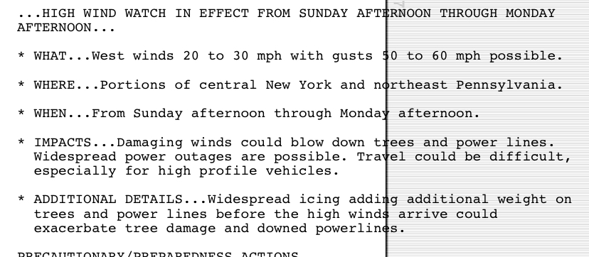
This got even more interesting. URGENT - WINTER WEATHER MESSAGE National Weather Service Binghamton NY 1204 PM EST Wed Nov 20 2024 NYZ057-062-210115- /O.CAN.KBGM.WW.Y.0021.241121T2100Z-241123T0600Z/ /O.EXA.KBGM.WS.A.0007.241121T2100Z-241122T2100Z/ Delaware-Sullivan- Including the cities of Delhi, Walton, and Monticello 1204 PM EST Wed Nov 20 2024 ...WINTER STORM WATCH IN EFFECT FROM THURSDAY AFTERNOON THROUGH FRIDAY AFTERNOON... ...WINTER WEATHER ADVISORY IS CANCELLED... * WHAT...Heavy wet snow possible. Total snow accumulations up to 8 inches possible in the higher elevations and up to 4 inches in lower elevations. * WHERE...Delaware and Sullivan Counties. * WHEN...From Thursday afternoon through Friday afternoon. * IMPACTS...The strong winds and weight of snow on tree limbs may down power lines and could cause sporadic power outages. Plan on slippery road conditions. The hazardous conditions could impact the Thursday evening and Friday morning commutes.
-
today's model runs might make things interesting even at my elevation, still can't yet count on it though but it would not be shocking to see MSV elevation and up pull a nice event from this. Far northern Sullivan will be in line for a good shot of snow from this for sure
-
Singing back in to start another round of winter--and what a good time to do so. Thursday-Friday is one of those razor's edge setups that, at least right now, I wouldn't anticipate seeing much outside of white grass at my elevation. The rain takes bigger precedent, for now.
-
4/1-4/2 severe threat (southern portion of subforum)
crossbowftw3 replied to largetornado's topic in Lakes/Ohio Valley
And when was the last 15 hatch across Ohio again? -
Maybe a surprise or two this week as a last hurrah snow but I wouldn’t count on it. Pretty much already set to be a complete wash
-
Meanwhile… some areas jumped from 0/2% to 15% hatched in the span of one update.

-
Some heathy gusts this morning. Hopefully, this will be the last big wind event until next fall—barring any tropical systems that come our way. And with the exceptionally active season predicted there will be at least one bound to head our way
-
Right around 3-4” from an initial forecast of c-1” A reverse bust from Tuesday, snow for the season now right around 25”
-
Winds were going something legitimately fierce last night, got another inch of snow out of it
-
Final total did indeed appear to be around 3” difference between 3” and a foot ended up at about 45 miles
-
May have stopped at this point with probably around 3” eyeballing, will check once I have to clear this out what a bizarre 24 hours this has been
-
2.5” 30-40 miles northwest of Middletown, this gradient should be interesting to see
