crossbowftw3
-
Posts
1,394 -
Joined
-
Last visited
Content Type
Profiles
Blogs
Forums
American Weather
Media Demo
Store
Gallery
Everything posted by crossbowftw3
-
Moderate incoming for the DelMarVa and parts southwest/northeast into S central PA
-
Relatively paltry 1-1.5” where I’m at in Sullivan, clearly a pretty horrendous situation developing southeast of here. Fort Montgomery might be approaching double digits if they haven’t by now
-
68/62 at 10 am definitely didn’t miss the pure muggy feeling.
-
A mid-south PDS severe watch in June is not often on the bingo card but here it is:
-
Severe Weather 3-23-23 through 3-26-23
crossbowftw3 replied to cheese007's topic in Central/Western States
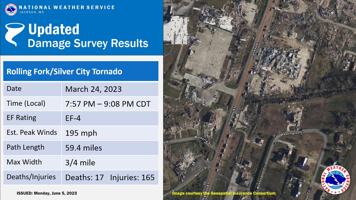
Rochelle officially 200 EF4, and most probably Chapman as well. -
Another day in the trenches, have never recalled it feeling this awful
-
Severe Weather 3-23-23 through 3-26-23
crossbowftw3 replied to cheese007's topic in Central/Western States
Rolling Fork upped to 195 EF4:
-
I watched this cell go directly overhead of me about half an hour earlier and I had a feeling something was getting ready to happen with it
-
If you can play the “read the cryptic tweets” game this would imply high risk coming at 1630 for somewhere in the larger zone edit: tweet has been deleted, too soon?
-
Largest area under a sig tornado hatching I’ve certainly seen as of late, a substantial event seems to be in the offing across the mid-south and points north towards Chicagoland
-
Likely no more snow here so final total ends at around 3-4”. Areas all around with elevation went for at least double of my totals
-
Indian Lake upstate got 31” so far, so somebody clearly got the goods. Been basically stuck with flurries for the last few hours now
-
Then that 10” in Bloomingburg doesn’t seem nearly as dubious, areas to my immediate west are coming in with the same 1-3” range I finished at. Strange. edit: Kiamesha with 10.5 as well, this is going to be one heck of a gradient in just this county then.
-
Windsor Massachusetts now up to 28.5” and still going there.
-
Finally went for a measure for MBY: 2.5-3” or so, which makes sense. That 10” in bloomingburg seems that much more dubious
-
From NWS’s graphical LSRs It may or may not be dubious however, considering the 9999.0 reports from other places this morning lol (I suspect it would be unless other evidence emerges)
-
10” in Bloomingburg which is in the easternmost extent of Sullivan and only 20 miles from MSV
-
Glad we won’t need to wait long to see near-50 degrees again (if things hold for Thursday-Friday)
-
MSV area only at 3.3” and they’ve got 500-600 of elevation on me
-
Seeing reports approaching 2’ from Mass/VT, they’re the clear winners of this one. 30+ seems like a certainty and a 40 spot isn’t unrealistic right now for them
-
Should be very interesting to see the gradient once the postmortem snowfall maps for this once are made. Seeing obs of 20+ already across parts of Massachusetts and VT/NH and they’ve got quite a ways to go there. 30+ seems a certainty for those areas and a 40 spot may not be too unrealistic at this time meanwhile; still barely 1-2” here and also a barely coated driveway
-
That town must be jumping for joy
-
Finally snowing at a good enough clip now, but still not making headway for accumulations. Binghamton did cut back their WSW to 5-8/8-15, but once again hard to see how there’d be many reports of that much at least around here.
-
3 am check of things confirmed my suspicions; a fairly sizable fail is unfolding here in western Sullivan, it may have finally flipped sure but it’d just seem it was hours too late. Perhaps barely 1-2” or so so far on car tops and grass, even 6+ may be in jeopardy
-
IVT has to push hard if we’re getting into anything on our side otherwise we’re busting quite low. BGM never changed from their 9-18 WSW for at least Sullivan