

crossbowftw3
-
Posts
1,394 -
Joined
-
Last visited
Content Type
Profiles
Blogs
Forums
American Weather
Media Demo
Store
Gallery
Everything posted by crossbowftw3
-
12/15 - 12/16 Coastal/Winter Storm & Observations
crossbowftw3 replied to Northof78's topic in New York City Metro
Should be quite easy for those three to remain all snow all the way through and get the double digits around here, but I’ll feel kinda high and dry if I do stay around 4-6” and those three do all make 12+ -
12/15 - 12/16 Coastal/Winter Storm & Observations
crossbowftw3 replied to Northof78's topic in New York City Metro
Couldn’t say I’d be shocked at that outcome since my ultimate results of any storm always differ wildly in these mixed bag situations as opposed to Rock Hill/MSV/what have you given the 300-400+ elevation changes in the matter of roughly 30 miles between where I am and those locations -
12/15 - 12/16 Coastal/Winter Storm & Observations
crossbowftw3 replied to Northof78's topic in New York City Metro
I’m swinging a bit lower end for MBY because I’m lower than most (maybe 750-900) but I should still pull at least 4-6 without much of a sweat before any junk mixes in if it gets here -
Finally reporting back for duty for another shift of wintertime at the same place as always 5” here and maybe we can squeeze out another 1-2” in Sullivan. Fun little storm and got in a trial run of new snowblower (it’s solid as I’d hope it’d be).
-
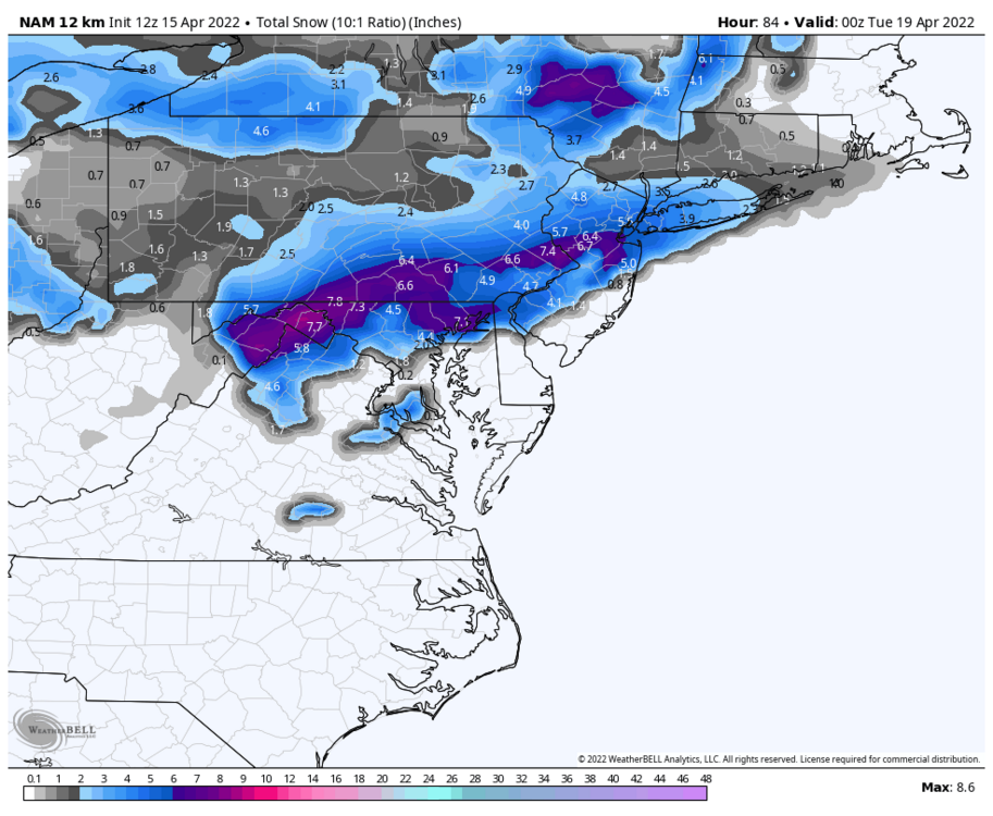
Binghamton is over 13” and still coming down for maybe one more hour there
-
Came up with maybe 1-2” of slush and there were definitely other ptypes mixing in through the night to make it feel like pure cement
-
Spring Snowstorm Obs. 4/18-4/19
crossbowftw3 replied to BuffaloWeather's topic in Upstate New York/Pennsylvania
An inch or two of slush, hard to tell exactly what ptypes there even were for most of the night -
From my best guesstimate with a lack of light to confirm I do not believe I actually saw any accumulations outside of grasses. Binghamton NWS office has a foot OTG and still snowing
-
Last night’s and this morning’s model runs are beginning to dance away from any real meaningful snow for those of us here who have that chance. CNY is looking like they’ll go gangbusters on this one lol
-
Central PA Spring 2022
crossbowftw3 replied to Itstrainingtime's topic in Upstate New York/Pennsylvania
I’m sure someone would do good with this information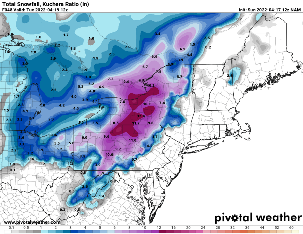
-
I’m about 1k feet lower in elevation than you. You probably will do better than me considering
-
I’m not particularly excited either but at my lower elevation I’m already preparing to get skunked
-
Upstate/Eastern New York-Springtime?
crossbowftw3 replied to BuffaloWeather's topic in Upstate New York/Pennsylvania
Midday NAMs painting general 4-8 (considering awful ratios) dropping to 2-4 my way in Sullivan -
Upstate/Eastern New York-Springtime?
crossbowftw3 replied to BuffaloWeather's topic in Upstate New York/Pennsylvania
From a mid afternoon high of 51 for me Monday on the euro and still being low 40s before precip moves in it seems I stay 33-34 most of the night with mixing most of the time enough to probably slash anything for me by half minimum but places higher in elevation will do well—MSV and further up -
Central PA Spring 2022
crossbowftw3 replied to Itstrainingtime's topic in Upstate New York/Pennsylvania
The impeccably good timing is the one thing that’ll make this work, otherwise not so much -
Upstate/Eastern New York-Springtime?
crossbowftw3 replied to BuffaloWeather's topic in Upstate New York/Pennsylvania
None of this surprises me anymore NAM out of best range but still
-
Ratios wouldn’t even be 10:1 in any event with temperatures +-1 on either side of 32 so any real accumulations probably do stay elevated
-
Central PA Spring 2022
crossbowftw3 replied to Itstrainingtime's topic in Upstate New York/Pennsylvania
Ratios probably struggling to even touch 10:1 but this should hardly be surprising anymore to see snow chances this late We’ll go right to summer by May 10th I’m sure knowing the last few years -
One last kick to the teeth? Ratios would obviously not even be close to 10:1
-
Upstate/Eastern New York-Springtime?
crossbowftw3 replied to BuffaloWeather's topic in Upstate New York/Pennsylvania
Not holding my breath in the lower elevations of the Catskills/Sullivan County but who’s even doing that at this point anyway, it’s April -
Last chance flakes for Monday night? Not likely, but I think the possibility is there
-
750’ in Sullivan and it’s actually pretty steady. Too low of an elevation to stick but this probably the end of the line until October minimum so best enjoy it
-
I’m right on the eastern flank of the enhanced risk. Fun afternoon ahead..
-
The last gasp band moving in from the west could drop another quick 1-2” before we’re completely done. Wouldn’t count on it considering it is hauling. Official measurements as I conclude round 1 of my cleanup confirm the 6” at my location thus far.
-
Still cranking at a good clip but I agree with the radar presentation. Ceilings have lifted considerably last hour and temperature went back up one degree. If this is how it ends…not bad. addendum: pushing 6” now. MLK was roughly 6.5” so just a little more to go to mark biggest storm of this winter.

