Kmlwx
-
Posts
13,333 -
Joined
-
Last visited
Content Type
Profiles
Blogs
Forums
American Weather
Media Demo
Store
Gallery
Everything posted by Kmlwx
-
Warning for ice would be 1/4 inch or more
-
Are you sure you aren't thinking about the 1" "during commute" for advisories. I do not recall something like you are mentioning in my 34 years living here.
-
Inverted trough?
-
I remember I was in Downtown Silver Spring having dinner and saw it start to snow. Only had to go from there to roughly MD-650 and Randolph Rd (back to the house) and it was extremely dangerous. Within about 30 minutes of getting home, the roads were all snow covered and by morning everything was SUPER icy. A winter containing an event like that (or two), a few few nice cold shots, and a moderate snow event or two (and if we are lucky a major one too) would be a perfect winter. But even without a MECS/BECS - a winter containing a good blend of the above (minus the major one) can be memorable....even if it isn't a 2013-2014 style wall-to-wall. And those types of arctic snow squalls are NOT something that the long rangers here are going to be able to spot with accuracy at range. That kind of crap is going to make itself known only once in range of things like the NAM nest etc.
-
Maybe of these arctic fronts can give us something like that dynamic snow squall setup from Valentine's Day 2015. That was a heck of an evening! I know we all want to chase legit snowstorms - but those mini dynamic ones can be 1) Very impactful and 2) Fun to nowcast in real time.
-
Bold of you to assume there will be a "next storm"
-
I hope so....it's also our holiday party today so at least by later I'd expect a surge of people coming in - including people we don't normally see...and thus "my monitor isn't turning on" calls.... We don't do IT "tiers" here so even as one of the managers....I take even the stupidest of calls right up there with my lower level employees.
-
I got to the office early before things started to go downhill on the roads. Guessing the office will be a ghost town this AM...We should have delayed...
-
Reiterates in my mind that if I want snow....I pretty much have to travel for it.
-
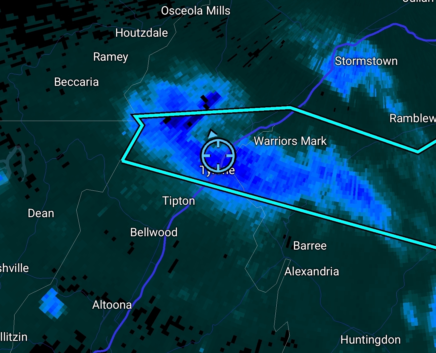
Crazy snow squall up here in Tyrone, PA. Quick quarter to half inch.

-
I use spaceweather.com and solarham.com I also get the Space Weather Alerts via text message.
-
Something LOUD just flew over Colesville area. ADS-B has something but it's not identified. Probably fighter jet(s) - only getting it periodically on MLAT tracking. 340+ knots if the MLAT is accurate.
-
yeah the shorter days could definitely help us! Fingers crossed (about all we can do with space weather - or ANY weather to be honest)
-
I would say potentially yes - the prior two may have "cleared the way" for this one. However, if it arrives too early it might not be well-timed with daylight/night.
-
BWI: 9.7" DCA: 5.0" IAD: 14.1" RIC: 2.2" (Tiebreaker) SBY: 0.6"
-
Well s**t...
-
Looking at guidance I think this is it once it's done. Save for maybe a few isolated showers. Not much I've seen has a late morning or afternoon line.
-
Sign me up for a severe t'storm day.
-
I always mention this - but anecdotally these convective lines are well know for coming in a bit earlier than progged at range.
- 1,378 replies
-
- 2
-

-
- severe
- thunderstorms
- (and 2 more)
-
Here's the LWX disco from that day .MESOSCALE... WATER VAPOR LOOP EARLY THIS MORNING PLACES A STRONG UPPER LOW ACROSS THE TENNESSEE VALLEY...MOVING TO THE NORTHEAST. A PRONOUNCED DRY SLOT IS PENETRATING WEST VIRGINIA AND SOUTHWEST VIRGINIA FROM THE WEST. 13Z SURFACE MESOANALYSIS PLACES A 993MB OCCLUDED CYCLONE IN SOUTHERN INDIANA...WITH THE OCCLUDED/COLD FRONT CUTTING THROUGH CENTRAL WEST VIRGINIA SOUTHEAST THROUGH THE CENTRAL CAROLINAS. A WARM FRONT IS PUNCHING NORTH INTO CENTRAL VIRGINIA...STALLING IN THE VICINITY OF THE WEST COAST OF THE CHESAPEAKE BAY. RUC MODEL INDICATES TONGUE OF RICH PRECIPITABLE WATER VALUES IS MOVING NORTH ALONG THE BLUE RIDGE (INCREASING FROM 12Z RAOB VALUES OF 1.3" TO 1.7"). MEANWHILE...DRY SLOT ALOFT IS OVERRUNNING RICH BOUNDARY LAYER MOISTURE...WHICH SHOULD INCREASE INSTABILITY AND CONVECTIVE UPDRAFT STRENGTH. GIVEN RICH PRECIPITABLE WATER VALUES AND DEWPOINTS JUST BEHIND THE OCCLUDED/COLD FRONT...CURRENT THINKING IS STRONG CONVECTIVE LINE WILL DEVELOP ALONG THE BOUNDARY WEST OF CURRENT PRECIPITATION. ROTATING STORMS WILL BE POSSIBLE IN SOUTH TO NORTH LINE SEGMENTS AHEAD OF THE COLD FRONT. SHEAR INDICES ARE QUITE HIGH TODAY. WIND PROFILES OBSERVED ON KLWX WIND PROFILE INDICATE SOUTHEAST WINDS 25 KNOTS AT 1KFT...INCREASING TO 60 KNOTS FROM THE SOUTH AT 3KFT. 06Z GFS BUFKIT FORECAST SOUNDINGS INDICATE 0-1 HELICITY GREATER THAN 200 M2/S2 AND 0-1KFT SHEAR OF 40 KNOTS THIS AFTERNOON...ESPECIALLY ACROSS CENTRAL VIRGINIA AND LOWER SOUTHERN MARYLAND. GIVEN ABOVE...THINKING THERE IS A POSSIBILITY FOR MULTIPLE TORNADOES ACROSS THE REGION THIS AFTERNOON. LOCALLY DAMAGING WINDS WILL OCCUR IN VICINITY OF STRONGEST UPDRAFTS. ANOMALOUSLY HIGH PRECIPITABLE WATER VALUES MAY PRODUCE LOCALIZED FLASH FLOODING. GFS IS PREFERRED MODEL AT THIS TIME GIVEN RECENT ISSUES WITH THE NAM (OVER-DEEPENING TROUGHS IS SLOWING DOWN TIMING OF COLD FRONT). &&
- 1,378 replies
-
- 2
-

-
- severe
- thunderstorms
- (and 2 more)
-
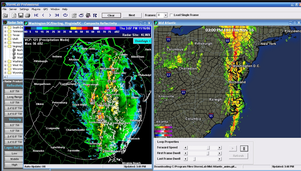
Found this screen cap I took. It was Nov 16, 2006. Haven't looked at H5 yet so it may not even be a close match - but anecdotally that's my high water level for Oct/Nov severe potential.
- 1,378 replies
-
- 2
-
-
- severe
- thunderstorms
- (and 2 more)
-
It's really one of those times when I might be "in" just purely based on the dynamics. Even without moisture it has the feels of one of those very gust shower lines...and more upside potentially. I think there was a really potent storm system in like November 2006 that did some fun stuff around these parts
-
It has my eye for sure - if a nice low pressure can be in the vicinity - fun things can happen even outside of peak heating. And honestly....I think peak heating becomes a lot less important this time of year and with a dynamic system.
-
0z Euro in the long range had Sandy Jr-esque 500mb look...
-
Saw a fireball this morning while driving NWish on MD-32 around 3:26am. Got a video and sent a report to https://www.amsmeteors.org/ - neat!