-
Posts
13,432 -
Joined
-
Last visited
Content Type
Profiles
Blogs
Forums
American Weather
Media Demo
Store
Gallery
Everything posted by Kmlwx
-
- 1,093 replies
-
- 2
-

-
- severe
- thunderstorms
-
(and 1 more)
Tagged with:
-
- 1,093 replies
-
- 6
-

-
- severe
- thunderstorms
-
(and 1 more)
Tagged with:
-
Just pondering the definitions and inner workings of SPC outlooks....I try not to be that person who continuously "forecasts the forecast" - but I could see SPC going to 75% wind but perhaps holding to CIG1. My reasoning is that the SPC outlooks are "within 25 miles of a point" - I don't think you're going to see much argument from most folks with setting that probability to 75% if severe criteria is 58mph. I'm less certain of TOR percentages - I am not sure that will go any higher than 15% unless there is a game time identification of a more robust corridor of tornado risk. Upping TOR percentages is harder because of the more isolated nature of that type of severe. If there truly is a QLCS - even if it only has sporadic swaths of 58mph winds in it - in a major metro corridor like I-95 - you're going to probably verify on damage reports pretty easily on the wind category. Anyway - I'm just rambling - and I do think we stick to a moderate - but I could see them tickling the high risk even more by bumping to 75%. They can go to 75% and still have this be a moderate risk.
- 1,093 replies
-
- 1
-

-
- severe
- thunderstorms
-
(and 1 more)
Tagged with:
-
https://x.com/forecaster25/status/2033247105238569123
- 1,093 replies
-
- 2
-

-
- severe
- thunderstorms
-
(and 1 more)
Tagged with:
-
In my mind right now - the "floor" is probably something like a semi-solid squall line of widespread 50-60mph winds with the synoptic winds behind it. Still could yield a lot of damage reports which could verify a high percentage (even if not high CIG) I suppose. I guess I could see a scenario where they pull the trigger on a high - but I agree with others that it would not be before 1630z tomorrow - and if they did it we'd potentially see one of those mesoscale discussions a couple hours before the actual outlook update to say "CATEGORICAL UPGRADE" I still think this is a moderate risk through and through - but can't deny some of the dynamics at play. If people "want" a high risk just for the wow factor - the messaging has already been intense enough all weekend to get the word out.
- 1,093 replies
-
- 3
-

-
- severe
- thunderstorms
-
(and 1 more)
Tagged with:
-
Yep - looks like zero changes locally. Discussion mentions continued uncertainty. The messaging is already intense - I think it's the right call not to bump to a HIGH.
- 1,093 replies
-
- 2
-

-
- severe
- thunderstorms
-
(and 1 more)
Tagged with:
-
And wasn't it you who said he is conservative normally? My personal thought is that we *don't* go to high risk - but it doesn't lessen the impact to many people that this system may have.
- 1,093 replies
-
- severe
- thunderstorms
-
(and 1 more)
Tagged with:
-
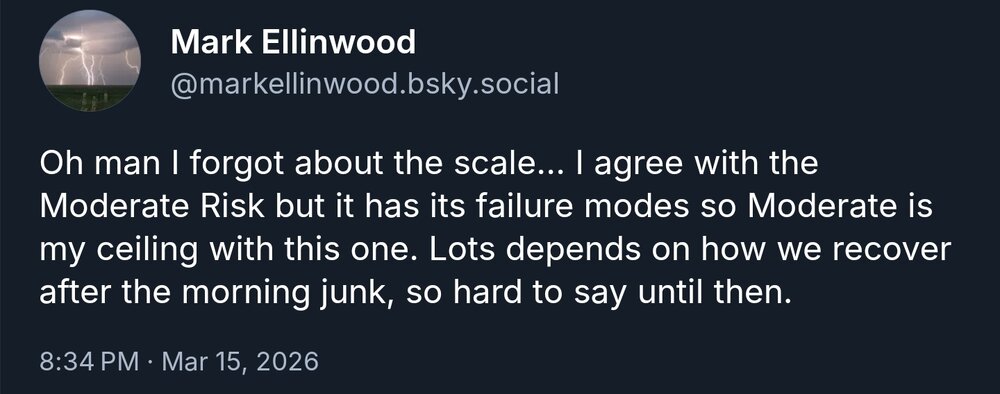
I very much doubt we will ever see a D2 high risk in the Mid-Atlantic. Even in a scenario like this - some form of failure mode exists.
- 1,093 replies
-
- severe
- thunderstorms
-
(and 1 more)
Tagged with:
-
Whoa... https://x.com/Drewshearer444/status/2033233835303878839 That would be crazy - even if it's more driven by the new outlook methods. I don't think Maryland has ever had a high risk if that's what he is implying they'd upgrade to.
- 1,093 replies
-
- severe
- thunderstorms
-
(and 1 more)
Tagged with:
-
I think Mark (Ellinwood) is still around just not as much. There are folks on here that used to (may still?) chat with him regularly.
- 1,093 replies
-
- severe
- thunderstorms
-
(and 1 more)
Tagged with:
-
The issue is social media. SPC stuff gets posted and reposted pretty virally both with/and without explanations from whoever is posting it.
- 1,093 replies
-
- severe
- thunderstorms
-
(and 1 more)
Tagged with:
-
I think SPC in general (probably more a discussion for the general severe thread) is not geared well towards public consumption. A person sees "slight risk" and doesn't take the threat seriously. Or they see "10% tornado" and are like big deal. We as weather weenies know how to evaluate this - but average Joe is not now, or in the past going to fundamentally understand SPC outlook categories or percentages. Some of the switch to "level X out of X" has helped - but hasn't eliminated the issue.
- 1,093 replies
-
- 2
-

-

-
- severe
- thunderstorms
-
(and 1 more)
Tagged with:
-
For those of you who haven't done any deep diving into the SPC videos for the new outlook styles - you could theoretically get an absurdly high PERCENTAGE now but with little or no CIG. That would be applied to times when 58-65mph winds for example might be a near lock and widespread - but the magnitude might not hit the 70-80mph+ range. The CIG categories are probably going to be the more important things to watch with this new era.
- 1,093 replies
-
- 3
-

-
- severe
- thunderstorms
-
(and 1 more)
Tagged with:
-
Well one thing is - I wonder if those CSU-MLP maps have to be adjusted to account for the new SPC methodology.
- 1,093 replies
-
- severe
- thunderstorms
-
(and 1 more)
Tagged with:
-
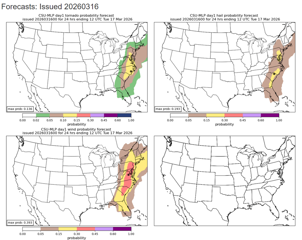
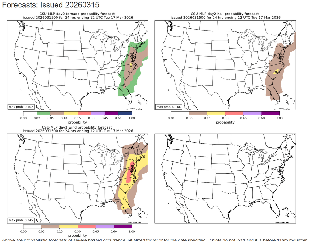
CSU MLP mostly held steady with wind but maybe tailored back the TOR risk just a touch. I'm not entirely shocked - and I've been thinking even with some models showing pre-line cells, that this would be a wind dominated event with some brief QLCS spinnys. Nonetheless - I think SPC is hitting the threat level very well!
- 1,093 replies
-
- 1
-

-
- severe
- thunderstorms
-
(and 1 more)
Tagged with:
-
Going to wait until 12z models before I do my little write-up for my office. While a ton of people at work (including in management) read my emails - they seldom apply my messaging to their actual decision making - which I don't blame them since I'm a weather weenie. But so far it has burned them a few times (during snow events) when they've closed too late (once people were already at the office) or haven't closed early enough in the afternoon leading to people having 3-5 hour commutes. I've *never* seen them release early for something other than snow...And I'm physically onsite tomorrow until 5:30pm. Great....with no windows too!
- 1,093 replies
-
- severe
- thunderstorms
-
(and 1 more)
Tagged with:
-
I do think linear convective systems in our region tend to roll through a bit earlier than even short range models predict. There are exceptions, of course - but with a solid line - it wouldn't shock me to see it bump 1-3 hours earlier as we close.
- 1,093 replies
-
- 2
-

-
- severe
- thunderstorms
-
(and 1 more)
Tagged with:
-
If you do, please be careful. Fast storm motions will make this potentially chaotic.
- 1,093 replies
-
- 1
-

-
- severe
- thunderstorms
-
(and 1 more)
Tagged with:
-
Continuing discussion and eventually observations/nowcast posts for the Monday severe weather event potential can go here. @WxUSAF or other mods please pin this thread if you get the chance. 15% TOR and 60% WIND are extremely rare in these parts. While I am not downplaying anything - I do think the appearance of 60% wind has a lot to do with the new SPC outlook methodology. Nonetheless, an active weather day tomorrow seems on tap. Usual failure modes still exist (stabilizing cloud cover or early day showers) The shear environment is pretty insane.
- 1,093 replies
-
- 6
-

-

-
- severe
- thunderstorms
-
(and 1 more)
Tagged with:
-
I'll get a separate thread started in a bit!
- 279 replies
-
- 3
-

-
- severe
- thunderstorms
-
(and 7 more)
Tagged with:
-
Unrelated - but has anyone else been having serious issues loading the SPC Events Archive pages? Eventually they load - but stuff is missing - and sometimes it just throws an error on the left navigation area entirely.
- 279 replies
-
- severe
- thunderstorms
-
(and 7 more)
Tagged with:
-
We do seem to go on "runs" at times. 2008 and 2012 come to mind. Also I still can't believe that College Park in 2001 and La Plata in 2002 were less than 8 months apart.
- 279 replies
-
- severe
- thunderstorms
-
(and 7 more)
Tagged with:
-
@mappy - Do you still have you mod powers? If I bump this event to a standalone thread after the afternoon day 2 outlook tomorrow can you pin it? Or I guess @WxUSAF is a mod too right?
- 279 replies
-
- 3
-

-
- severe
- thunderstorms
-
(and 7 more)
Tagged with:
-
Let's wait and see how things look tomorrow. Again - we have traditionally (at least since the past few years) kept things mostly contained within this thread. If there is no reduction in the threat level tomorrow afternoon or evening - perhaps we can do a shorter term obs thread/damage report thread. While the potential for a high end event is definitely there - you'd be crazy to assume we are guaranteed a high end event. There are too many failure methods with Mid-Atlantic severe. Would be silly to have a thread that ends up being for a 50-60mph line of gusty storms. We've seen many events look robust at day 2 to fizzle the day of - heck even some day 1 big dog potentials have fizzled.
- 279 replies
-
- 3
-

-
- severe
- thunderstorms
-
(and 7 more)
Tagged with:


