tiger_deF
-
Posts
615 -
Joined
-
Last visited
Content Type
Profiles
Blogs
Forums
American Weather
Media Demo
Store
Gallery
Everything posted by tiger_deF
-
-
Any trends in the EPS guidance that we will be able to see in roughly half an hour will show us whether this was a western outlier or an actual trend
-
We are gonna be in for a rough suprise in the future, we can debate all we want about the intensity and cause of global warming but it's clear at least for the southern folks that snow events have been torching more and more often
-
If a catastrophic meteor hits and moves the atmosphere in just the right way, I could see the remnants of Teddy being hurled over the Yucatan provided the angle was right
-
GFS a little to the east but really jucing the trough this run, NS might be getting slammed. The turn west is also much more aggressive
-
Nah if anything I'd say he is a true weenie
-
Phoenix Records its Hottest Summer on Record
tiger_deF replied to donsutherland1's topic in Climate Change
I respect your opinion, but I flagrantly disagree, especially with the NHC part. As far as I can tell the NHC has only named systems that have definite tropical charicteristics, and aside from an early subtropical storm, all the systems we have had have pretty clearly been warm core systems with winds above 40 miles per hour and a closed surface low, which is all that is needed for naming. The NHC's job is hard enough without people shitting on them for political reasons -
I can't believe how fast everyone here is ready to move on from this. Just because we've been hurt so many times in the past by tropical whiffs doesn't mean that all of them will. Hell, the GFS 6z run just caved a little further with the west movement up North (though still a NS storm with an escape route). 6 days out, plenty can change
-
The HAFS and even JMA have picked up on a turn west. Still into NS and Northern Maine, but this absolutely bears watching for us folks down south
-
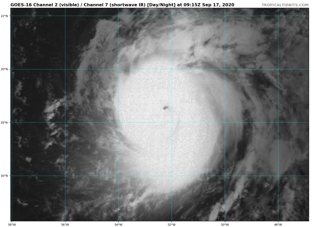
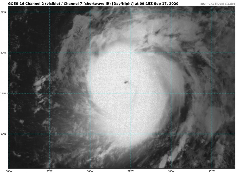
Eye see you Teddy
-
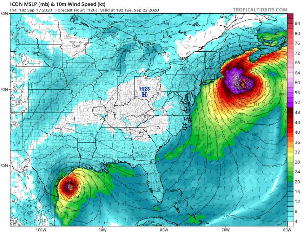
0z ICON captures it under the high and brings it west barely off the coast of Maine where it then slams into NS, 0z GFS continues to show a less dominant, more tilted high that lets Teddy escape to the east. Interestingly enough, both the ICON and GFS show at least some westward component as it moves North. Synoptically I'd say the GFS just caved a little to the Euro
-
Phoenix Records its Hottest Summer on Record
tiger_deF replied to donsutherland1's topic in Climate Change
Just looking at the temperature rise in the past 200 years compared to changes in climate we've observed over thousands of years, the warming now is faster by orders of magnitude. I've suspected our climate might be somewhat more moderating than we expect, but I see no other reason besides human emissions of some kind that the temperature has risen so suddenly and consistently, despite a few "dips" -
Looking at that bonkers ICON run and the EPS ensembles that really push for a NE hit, the massive blocking high pressure over NE actually generates a second area of weaker high pressure right over atlantic Canada, which causes the turn. Something to look out for in future model runs.
-
West =
-
All worth it for the rare coastal Noreaster
-
I get that this is an incredibly precise setup that will most likely not happen, but how is a single shift in the GFS more accurate than days of EPS runs?
-
Been there since that ICON run yesterday my friend
-
Again as with the EPS, like 10-20% of those runs would be absolutely disastrous assuming Teddy becomes as strong as forecasted, along with the baroclinic forcing as it starts to transition
-
This is setting up to be either a huge disappointment (or relief depending on the poster) or potentially a high impact event
-
Big weenie setup on the ICON, let's see if it holds the next few days
-
Another day, another SW shift on the GFS
-
Yeah, the pattern that would produce a serious storm up here is like a meteorological needle in a haystack. That being said, there is definitely potential for conditions that would be conducive to a pull west provided everything comes together, and I think that we should be tracking this until the models (especially the EPS) move back east. In addition, Teddy is forecasted to be an enormous and powerful storm, especially once it interacts with the trough, so if for some ungodly reason a NE situation did verify, it would likely be serious.
-
This season feels similar to 2004 in terms of impacts, however instead of tracking powerful, longtracking canes that usually made landfall past their peak, we've been tracking areas of vorticity and elongated waves that suddenly decide to get their act together within days of landfall
-
Euro with the left hook, where have we seen that before Still looking to be OTS but I would say chances of some kind of impact have risen somewhat
-
Major shift west for the GFS