
Steve25
-
Posts
726 -
Joined
-
Last visited
Content Type
Profiles
Blogs
Forums
American Weather
Media Demo
Store
Gallery
Everything posted by Steve25
-

2023 Mid-Atlantic Severe Wx Thread (General Discussion)
Steve25 replied to Kmlwx's topic in Mid Atlantic
Idk where you all are feeling any "dry" air or winds. It feels like soup out here in Baltimore. It's mid-morning and the Temp is in the 80s with dew in the 70s. -
I'm just happy after our painful dry stretch, there's a chance of rain every day in the 10 day outlook. Lots of ugly brown areas in the grass. The ground is begging for it
-
Trying to figure out exactly what we're looking at for Saturday. It was looking like an all night washout not too long ago, but suddenly the NAM makes it look like a rather intense line of storms for a few hours during the afternoon.
-
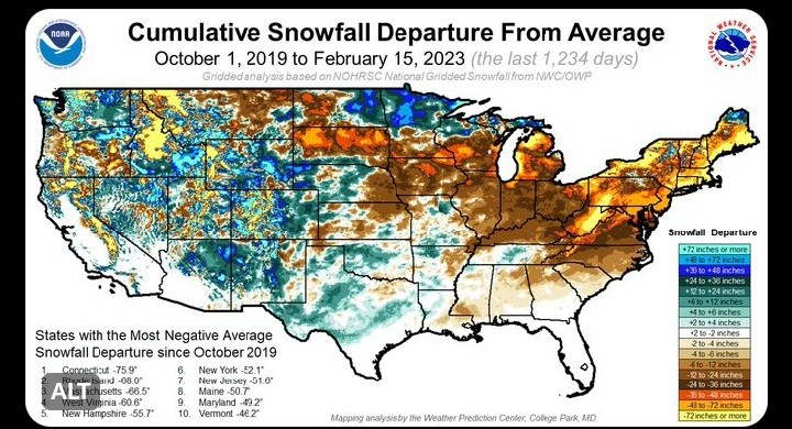
I was well aware of that when I shared it. I was only illustrating that most of the eastern US has been respectively well below average over the past 4 winters. Obviously the more snow you average, the easier it is to be significantly below average in terms of inches. At the end of the day though, below average is still below average.
-
I find it interesting that it's basically the entire eastern half of the country struggling the past several winters, not just our area. In fact, Maryland is 9th on the list of states with negative departure from average snowfall the past 4 winters.
-
I appreciate those of you still tracking. You do good work. I truly hope it works out. The idea of getting a snowstorm in late March after a full winter without even a tenth of an inch in my backyard is so stupid that it just might work lol
-
I may be the only one, but statistically I think it's pretty wild that I've lived through Baltimore's best and worst winters of all time, just in the past 13 years. Major extremes.
-
Meh, when things are already at rock bottom for the winter, creating a thread can't hurt anyone
-
March Medium/Long Range Thread: The Empire Strikes Back
Steve25 replied to stormtracker's topic in Mid Atlantic
Forever 10 days out -
Enjoying my sleet pellets in Parkville!
-
When the GFS shows no snow accumulation 10 days out: "It's over, look to the next window of opportunity" When the GFS shows good snow accumulation 10 days out: "It's 10 days away, we all know that's not going to be right."
-
This is a great point. If people are locking themselves in for storms 7+ days out, the heartbreak is not on the models, it's on you.
-
There would be something so chaotic and poetic about getting a decent snow/ice storm in March just as most have completely turned the corner to Spring. Especially following one of, if not the worst December through February our region has ever seen.
-
Late February will be rocking. February Long range Discussion thread
Steve25 replied to Ji's topic in Mid Atlantic
Would anyone really be surprised with how ridiculous our weather is that we would go into March with the worst winter of all time and then suddenly we get some winter just when everyone has fully moved onto Spring? -
Late February will be rocking. February Long range Discussion thread
Steve25 replied to Ji's topic in Mid Atlantic
Wild to think if late February/March doesn't offer any redemption, I will have lived through Baltimore's best and worst winters of all time(in terms of snowfall) already in my lifetime. -
Late February will be rocking. February Long range Discussion thread
Steve25 replied to Ji's topic in Mid Atlantic
Yeah I wasn't saying you've repeated it. It's just been said A LOT in general -
Late February will be rocking. February Long range Discussion thread
Steve25 replied to Ji's topic in Mid Atlantic
We see a message along these lines at least once every page of this discussion, yet the pages continue to pile up -
I personally enjoy winter regardless of what happens because I just absolutely loathe the hot and humid weather and almost everything that comes with it. My seasonal depression is quite the opposite of everyone else. Once we hit April my mind becomes a dark place lol. It definitely SUCKS to not have the fun parts of winter this year like the snow, ice, extended cold stretches etc. Still very much at peace due to the general chill, short days, and quiet/bare nature. I do feel for those who ONLY like winter for snow. This has got to be pure torture.
-
January/February Mid/Long Range Disco IV: A New Hope
Steve25 replied to stormtracker's topic in Mid Atlantic
Just a little tidbit. If BWI does go the rest of January without recording a trace, it will be the first time ever with a clean 0 in the snow department heading into February. From the factory of useless knowledge lol. They've done a trace going into February before, but never 0. -
Can't kill something that was already dead.
-
January Mid/Long Range Disco 3: The great recovery or shut the blinds?
Steve25 replied to psuhoffman's topic in Mid Atlantic
Correct me if I'm wrong, but that cold hasn't fully shown up on the other models recently, has it? -
January Mid/Long Range Disco 3: The great recovery or shut the blinds?
Steve25 replied to psuhoffman's topic in Mid Atlantic
Are you sure that's not supposed to be +75000? -
January Mid/Long Range Disco 3: The great recovery or shut the blinds?
Steve25 replied to psuhoffman's topic in Mid Atlantic
This forum has officially switched from most of the users hoping for any kind of snow events... to harassing anyone hopeful for snow, telling them it will never snow again this winter or any other winter in the future in this region so get used to it -
That's what I've been saying. Every day that passes, BWI gets a little closer to setting the all time record!
-
Have switched to the mindset that if it's going to be bad, let's shoot for historically bad so at least we can say we experienced a record! Still very much in play for the record lowest season snowfall for BWI. Currently standing at 0.7 in 1949/50.


