
Steve25
-
Posts
727 -
Joined
-
Last visited
Content Type
Profiles
Blogs
Forums
American Weather
Media Demo
Store
Gallery
Everything posted by Steve25
-
I know it's petty of me, but I am glad all the other 95 cities are going to get shafted as well.
-
*waves white flag for this storm* To the rest of you, hopefully my giving up will spark a big shift, but I personally can't continue to put myself through this false desperation hope
-
Best case scenario for a lot of the people biting their fingernails on this one is a front end thump of 4-6 inches and then dry slot. The models have been pretty consistent with the inland track for a while now. I know we're all just desperately hoping it'll randomly come substantially east but there appears to be no signs at all that that's even a reasonable hope for this one. No doom and gloom, just seeing what's being portrayed.
-
To those who understand the intricacies of all this and wouldn't mind giving me a little lesson. What is the driving force(or lack of a driving force) allowing the low to track right up over our area vs becoming a full blown coastal? With so many people just hoping it will come east, what specifically would need to happen differently with the setup currently being depicted to even allow for it to come substantially east, and is that even any bit realistic to hope for at this point?
-
Frankly, at this point I'm just hoping for as little heavy rain as possible around Baltimore. If it's possible to go snow/sleet to dry slot, all aboard!
-
I remember this but I don't recall specifics.
-
Is this technically what the model is saying the "end result" will be though? Or is this just the total snowfall from before the changeover, then you use your imagination to figure out how much of it gets wiped away by rain?
-
That snow would be followed and potentially washed away by very heavy rain though, am I right about that? Specifically near the Metros.
-
I agree with this. I love the cold nearly as much as the snow. Get as much of a thrill taking a hike on a bitter cold day as I do taking a snow walk. So if I had the choice between suppression allowing us to be cold dry vs amped forcing us into a sloppy mess and rain, I'm going suppressed.
-
To be fair, no one should be flipping out either in panic or celebration 4.5 days away. If we see the same exact results on the models for multiple days, then take things more seriously.
-
So in summary, the 12z suite puts a major Northeast/East Coast storm well in play for late weekend. Controls keep track inland which keeps significant snows west of the metros. Ensembles provide hope for a more coastal track. Too much time and stress left between now and Sunday.
-
It's a good thing the ensemble looks much better
-
I can't see details on Euro, but it looked like it had 3 consecutive near hits in a row, if I see it correctly.
-
Oh cool! I've gotta leave for work before sunrise so not exactly wanting icy roads or sidewalks to be honest. But one winter there was a situation like this and my car was a brick of ice the next morning.
-
So with it being rainy most of the rest of the day along with snow melt, along with temps dropping to the low 20s tonight, are things going to be frozen solid tomorrow morning?
-
Giving up on a pattern thats 7+ days away is just as ignorant as locking in on a great looking pattern from the mid to long range.
-
Same exact thing in my neighborhood. Power will go out on the most clear days out of the blue. Never goes out during storms though.
-
Dark days? All I've seen in here recently is how incredible the pattern setup looks to be from Mid to Late January. To be fair I only start really looking once there's potential within 7 days, but how does the vibe go from incredible potential to dark days seemingly overnight? Not criticizing, I'm genuinely curious.
-
Anyone know where I can find official accumulation reports from trained spotters?
-
Measured in Parkville in several clean spots and got spots of 4, spots of 5, and spots between the two. So I'm going to unofficially say 4.5 and wait for some official reports to start rolling in. More than pleasantly surprised!
-
Now we do 4 out of 5 very cold days(with a sloppy Sunday in-between)
-
The geography in this area is definitely crazy. I'm not in one of the NW spots, but I'm JUST west of 95 in NE Baltimore and I've felt very fortunate over the years because I'm usually barely NW of the battle zone for precip types in bigger storms.
-
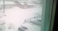
Parkville(NE Baltimore). Decided to sleep through this one, expecting a 1-2 inch event. My brain must be in tune because I randomly woke up at 1 AM and it seemed to be right around when it started, then randomly woke up about 15 minutes ago go heavy snowfall. I haven't gotten out of bed but just by eyeing it out the window, I'd guess there's a solid 3+ out there.
-
Don't the metros usually struggle with dry spots when you're dealing with a transfer to the coast? Then when you combine how quick this one is moving, just doesn't seem like a great formula. Im sure I'm missing something, as I'm lacking in the knowledge many of you have.
-
Parkville here too! Moving to Canada sounds pretty awesome!


