
Steve25
-
Posts
727 -
Joined
-
Last visited
Content Type
Profiles
Blogs
Forums
American Weather
Media Demo
Store
Gallery
Everything posted by Steve25
-
Nam has temps topping out around 45 tomorrow. 38 around 1 AM when some light rain creeps in, then temps plunge as heavy precip moves in. Changes to snow and it rips from about 2-4 AM to 8-10 AM with temperatures hovering right around freezing. This is for the Baltimore area.
-

Feb Long Range Discussion (Day 3 and beyond) - MERGED
Steve25 replied to WinterWxLuvr's topic in Mid Atlantic
I always want the snow, don't get me wrong. Oh I know most hate it. I was just clarifying that not all hate it. The only winter weather I truly dislike is when there's no cold or wintry precipitation of any kind, like most of January of this winter. It'll be interesting to see if the Euro caves to the suppressed idea or if the GFS brings it closer for this Sunday. -
Feb Long Range Discussion (Day 3 and beyond) - MERGED
Steve25 replied to WinterWxLuvr's topic in Mid Atlantic
Not true. I love cold and dry. Love taking hikes and checking to see how frozen the little bodies of water around here are during/after an extended bitter cold stretch. -
Jan 31st - 33rd Storm Obs and Disco like it's 1979
Steve25 replied to Bob Chill's topic in Mid Atlantic
Yeah, I'm just northeast of Baltimore. Got 3.5 inches Sunday. Just an additional coating during Monday afternoon, the heavier bursts didn't last long enough to have much impact. Then added an extra inch last night. So 4.5 in the end. I'll take it! -
Temperatures not getting much above freezing all next week possibly? Storms or not, I'd be thrilled. I know a lot of you don't like cold and dry, but I love winter weeks like that! Looks like great hiking weather Monday!
-
Jan 31st - 33rd Storm Obs and Disco like it's 1979
Steve25 replied to Bob Chill's topic in Mid Atlantic
So if I'm understanding correctly now the upper levels are cooling but the surface is warming. So heavier precip should fall in the form of sleet or eventually snow? -
Jan 31st - 33rd Storm Obs and Disco like it's 1979
Steve25 replied to Bob Chill's topic in Mid Atlantic
My roads all around my neighborhood are snow and ice combined. I'm glad I don't have to go anywhere today because I don't think my little Nissan could do it lol. Just north of Baltimore. -
Jan 31st - 33rd Storm Obs and Disco like it's 1979
Steve25 replied to Bob Chill's topic in Mid Atlantic
For just barely northeast of Baltimore City my expectations from this storm from a few days ago werr 2-5 inches from Sunday. Got 3.5, so good to go there. I did say 3-7 for the coastal impact. Feel like I might be able to scrape the low end of that range, but confidence is low. Some model guidance is keeping the hope alive. -
Jan 31st - 33rd Storm Obs and Disco like it's 1979
Steve25 replied to Bob Chill's topic in Mid Atlantic
Love this! Had a similar type of day. It's not what we'd dream of, but it is plenty to enjoy in many ways! -
Jan 31st - 33rd Storm Obs and Disco like it's 1979
Steve25 replied to Bob Chill's topic in Mid Atlantic
Parkville- Breezy, light snow. Got close to 3 inches today. The pixie dust snow was a bit disappointing today cutting down on accumulations, but I expected 2-5 today so wound up in that range. If I'm not misunderstood, we should still get light/moderate snow tomorrow afternoon, maybe a few more inches? -
Jan 31st - 33rd Storm Obs and Disco like it's 1979
Steve25 replied to Bob Chill's topic in Mid Atlantic
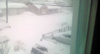
And just like that, first flurries- Parkville 21234 -
Jan 31st - 33rd Storm Obs and Disco like it's 1979
Steve25 replied to Bob Chill's topic in Mid Atlantic
Blue skies breaking through the clouds in Baltimore -
Jan 31st - 33rd Storm Obs and Disco like it's 1979
Steve25 replied to Bob Chill's topic in Mid Atlantic
I had slim hopes for something big here in Baltimore, but I've put myself back into "Enjoy every flake mode." But I would love something I could shovel! About to do my walk for the onset! -
As one of the few in here that actually believes in the NAM, especially within range, it's consistency is a major red flag. I know NO ONE wants to hear that though. I'd take the NAM in a street fight over the RGEM most days. I'm wrong a lot in life though, and I often put my confidence in the wrong things, so hopefully this is just another one of those times.
-
Jan 31st - 33rd Storm Obs and Disco like it's 1979
Steve25 replied to Bob Chill's topic in Mid Atlantic
I guess people can say the NAM is basically alone on that line of thought, I think? -
Jan 31st - 33rd Storm Obs and Disco like it's 1979
Steve25 replied to Bob Chill's topic in Mid Atlantic
Definitely not going to argue with that! Not sure why the reading I got was 2 degrees cooler. Cool to have another Parkville person in here! -
Jan 31st - 33rd Storm Obs and Disco like it's 1979
Steve25 replied to Bob Chill's topic in Mid Atlantic
I got 27 in Parkville, but to be fair I'm using online sources. Sounds like you may have your own temperature gauge. -
Jan 31st - 33rd Storm Obs and Disco like it's 1979
Steve25 replied to Bob Chill's topic in Mid Atlantic
Been away most of the day, just had a quick model question. Is the RGEM the only model showing major accumulations(12+) near Baltimore region? -
Jan 31st - 33rd Storm Obs and Disco like it's 1979
Steve25 replied to Bob Chill's topic in Mid Atlantic
27/16 in Parkville. JUST northeast of Baltimore City. -
Definitely banter, but I'm stressing over temps IMBY basically not dropping at all tonight due to nagging cloud cover, which may lead to temps being a little warmer than expected tomorrow and so on and so forth. A couple degrees could make a huge difference yada yada
-
To my untrained eye the NAM seems good for Baltimore folks
-
The models all generally agree with a front end thump of at least a few inches, right? So what were discussing is if we'd prefer to just get that thump and then the coastal never really takes shape for our area so the boom coastal scenario is taken off the board...or if we'd rather the coastal work out, but with it comes the risk of mixing or a dry slot? Maybe I'm just gambling too much, but I live for the big storms. Especially if I'm getting the front end thump regardless! I will enjoy that thump no matter what follows, so give me the chance for more over no chance.
-
At this range I think you'd have to say anything is still on the table but I'm seeing 4 most possible scenarios. 1. The system stays a bit further north. We get a thump of snow Sunday but then the transfer to the coast occurs sloppy and north, leading to us getting some rain and maybe eventually ending as some wrap around snow showers as the storm pulls off. Basically something like what the GFS has been touting. 2. The coastal transfer to our southeast as being shown by the Euro. All would start as a thump of snow later on Sunday, but from there are the different outcomes. 2a. The coastal stays in the best placement off shore being not too close but not too far and we get our big one we are hoping for. 2b. The coastal hugs too far west and leads to a mix or changeover to rain for the height of the storm. 2c. The coastal is too far east, keeping the bulk of the precipitation out of our areas. Also, 2016 was pretty rare. Not often does this area have the ability to nail down a monster snowstorm from distance with no real concerns over details. Expecting every, or any, big winter storms to be as easy as that was is a pipe dream in most cases.
-
January Storm Term Threat Discussions (Day 3 - Day 7)
Steve25 replied to WxUSAF's topic in Mid Atlantic
I've noticed a bit of a trend this winter, that there have been some insane model results from 6-7 days away, people have gotten really hyped up, and then around day 5 the models tend to get a much more realistic grasp on things, then within 5 days the more fine details are worked out. It's taught me not to buy in to any solutions at all until the height of the storm is within 120 hours on the models. So, if the models are still on board for a decent snowstorm of any variety come tomorrow's 12z suite, I'll jump on the train. Until then, I wish you all the best. Hoping there's no crumble overnight.
-
LOL


