
Steve25
-
Posts
727 -
Joined
-
Last visited
Content Type
Profiles
Blogs
Forums
American Weather
Media Demo
Store
Gallery
Everything posted by Steve25
-
If there's anyone LOCKED IN or GIVING UP on any potential that's 10 days away, I'm sorry.
-
I'm mostly just curious how the roads will be early Friday morning. Obviously 2 inches of fluff feels like it shouldn't cause any big problems but around Baltimore you just never know. Especially for my old car.
-
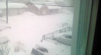
A little late to reporting, but exactly 3 inches in the NE corner of Baltimore City. It was pure snow from 3:30 AM to 11:30 AM, just never quite got into those heavy bands. It was beautiful though, especially when the breeze picked up and the snow got fluffy and was blowing all around. I'll happily take 3 inches to kick off my winter. Congratulations to all the further south folks who scored big! I look forward to reading through all the totals a little later.
-
Going on about 4 hours of snowfall in NE Baltimore and basically still just a sloppy maybe .75 inch on grass. Still absolutely nothing on any pavement. Looking like if I'm going to get pavement accumulation I'm going to need some serious rates in the next few hours.
-
Got about 40 minutes into my walk in NE Baltimore. It's been a consistent light to moderate snow. Grass is pure white but pavement really struggling to cave. Saw LITTLE signs of caving within the past few minutes, will see if that continues. Snow is VERY WET as expected. Unfortunately can't get many pics because my phone isn't waterproof
-
As I'm not sure what to expect as the morning progresses in Baltimore, I'm going to go out for a walk right now and enjoy this moment. First real snowfall of the winter!
-
Been straight up light/moderate snow in the Northeast corner of Baltimore City since about 3:30. Cold surfaces have a coating. Pavement not caving yet. Just nice to watch the snow fall.
-
Going to be wild in Baltimore County today. There are going to be some people talking about how awesome the snow is and others who are like "What snow are you talking about?" As someone that drives from more north/central Baltimore County to the far southeast corner of the county for work, it'll be interesting.
-
Okay thanks. As a snow lover like most of us, will be disappointing to be so close to big amounts BUT I am going to enjoy whatever I can get because anything is better than nothing! Also very happy for the folks in the jackpot zone as everyone knows they've been in the shaft zone way too many times over the years!
-
Putting my faith in you guys because my untrained eye when it comes to nowcasting surely will deceive me. Looking at the radar in total, how do you think things are looking for an area just barely northeast of Baltimore City? Light/moderate snow event throughout the morning, like 2-3 inches? Just trying to figure out my morning plans.
-
Are you guys saying Tom is wrong around Baltimore or because of his totals further south? Because I feel 1-3 is very much in the cards around Baltimore, especially northern/western areas of Baltimore.
-
I'm right near Baltimore, and I do recall a VERY COLD stretch of weather at the very end of December/beginning of January in 2017/2018. It didn't escape the 20s for like 10 consecutive days. I think there were a couple days in the teens as well. I specifically remember it because a major lake nearby froze completely over. Honestly the last memorable winter event I can remember.
-
I will say that it's very nice to finally see a forecast with plenty of days hanging in the 30s for highs. I'll take any taste of winter ❄️
-
I swear Wunderground used to allow me to look up past dates and see the radar images. Can't seem to do it anymore. I'm trying to get the radar from January 26th, 2011. I'm shocked with how advanced technology is nowadays that there's not easy to find access to historical radar. If anyone knows if there's anywhere I can find that, I'd be very appreciative.
-
I'm not nearly as knowledgeable as some of the folks in here, but I still find so much humor in the fact that people make definitive statements about a season several months away when they seem to still struggle to nail down the particulars of a forecast a week away, or in some cases even a few days. I get that there are signals you can look to that give a general idea for what to reasonably expect, but it's such a crapshoot. Meteorology is such a wild field of complexities and confusion.
-
Just a tidbit I find interesting that I figured I'd throw into the conversation. BWI is in a streak of 5 consecutive winters without recording a month with double digit snow totals. BWI has done that 3 separate times in the 137 years of keeping official records. NEVER has it been done in 6 consecutive winters.
-
Literally just let my dog out and can hear them making noises in the trees. This is some straight up garbage. It's February...
-
How do you deal with your phobia? I have it too.
-
I was 10 years old for the last cicada outbreak and I honestly think it created my phobia of buzzing insects. My parents have sworn I never had a fear like that as a young kid. Ever since then, Summers have been a living nightmare for me. I literally have had anxiety attacks at the end of every winter thinking about the arrival of the warm seasons. Stress is at an all time high all Spring and Summer. Literally stare out the door for several minutes to be sure there's nothing flying around everytime I leave a building or car. It's just, misery. I know I need psychiatric help. I hate it. I'm legitimately mulling over my options of moving out of state in May and June of this Summer to avoid the worst of it. Much easier said than done though.
-
If you live in an area with trees, they're going to be EVERYWHERE. If you live in an area with mostly just buildings, you probably won't experience too many of them.
-
It's on my mind at least once a day...
-
I tell myself that all Summer long. Just keep grinding through lol.
-
My issue is that winter is all I've got. I loathe Spring and Summer with a passion. The growing plant life, bugs, heat, humidity. It's awful. So I start getting bummed around this time every winter just because I know no matter if there's wintry weather in March, were still right around the corner from the inevitable arrival of the warm seasons.
-
Not going to be picky. Winter storm is a winter storm. Honestly, an ice bombs justifies my decision to take off today more than snow would have. Haven't ever really experienced a sleet/freezing rain storm before, so something to remember. Let's go!
-
Going on an ice walk! I'll take any type of winter storm over a 50 degree rain storm!


