cptcatz
-
Posts
1,077 -
Joined
-
Last visited
Content Type
Profiles
Blogs
Forums
American Weather
Media Demo
Store
Gallery
Everything posted by cptcatz
-
2021 Atlantic Hurricane season
cptcatz replied to StormchaserChuck!'s topic in Tropical Headquarters
About time we get a good GFS fantasycane...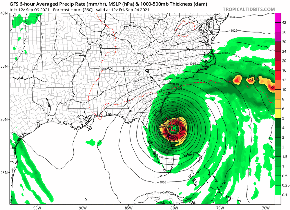
-
2021 Atlantic Hurricane season
cptcatz replied to StormchaserChuck!'s topic in Tropical Headquarters
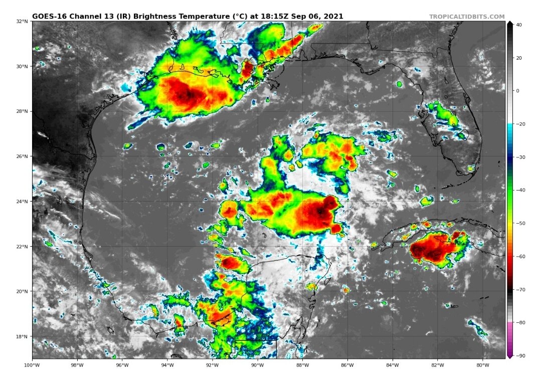
Interesting development of 91L. The eastern convection from yesterday has fizzled but new broad convection has popped up on the western side and just recently it looks like more is bubbling up right in the center. If this can tighten into a core it would have quite a bit of Gulf to work with before Florida...
-
2021 Atlantic Hurricane season
cptcatz replied to StormchaserChuck!'s topic in Tropical Headquarters
Regardless, looking at where the convection is right now, you may get some nice storms where it ends up going. -
2021 Atlantic Hurricane season
cptcatz replied to StormchaserChuck!'s topic in Tropical Headquarters
91L is firing off some decent convection and it looks way more south/east than where NHC is showing it. Florida might need to watch this.
-
2021 Atlantic Hurricane season
cptcatz replied to StormchaserChuck!'s topic in Tropical Headquarters
GFS and Euro are trash in the long term. How do you still base your opinion on their 10-15 day forecast? It makes you look like an idiot after you're wrong time after time. -
2021 Atlantic Hurricane season
cptcatz replied to StormchaserChuck!'s topic in Tropical Headquarters
It's weird. Like Twitter politics trolling is understandable but like this guy obviously has an interest in weather but still chooses to use his time to come to a weather forum and troll a relatively small group of people. Kinda sad to me, but whatever floats his boat. -
Floyd caused river/stream flooding but I don't believe it caused the kind of urban flash flooding in upland areas like that occurred last night. I lived in Essex County during Floyd in a relatively low lying house with a basement. We didn't get any water intrusion during Floyd. I still have a lot of friends in NJ and they all had flooding around their houses last night like never before. I don't know, maybe I'm wrong but we'll see when the numbers start coming out.
-
Not sure how this doesn't match or exceed Sandy. It looks like all the coastal areas that flooded in Sandy flooded here too, as well as the widespread inland areas that flooded last night that were pretty much unscathed in Sandy. Flooding rains aren't as exciting to the media as a landfalling hurricane-equivalent superstorm, but I have a feeling when the insurance claims are all in, this will be comparable or exceed the Sandy costs.
-
I wouldn't be so sure about that. The Sandy impacts were mainly from coastal flooding with moderate wind impacts throughout the rest of the region. Inland area impacts were limited to widespread power outages from falling tree limbs and transformer blowouts. The bulk of the costly impacts were from the surge flooding along the coasts, flooding all the tunnels, basements, utility rooms, etc. in the coastal areas. In contrast, last night's flooding looked to include all the coastal areas that Sandy flooded, IN ADDITION to incredible widespread inland flooding throughout the rest of the highly densely populated metropolitan region. Flooding insurance claims are FAR more expensive than moderate wind damage and there are going to be a ton of inland houses and office buildings waking up to feet of water in their basements this morning. Once people start assessing the damage today, this is gonna turn ugly and astronomically expensive.
-
This could be a worse disaster for the NYC metro region than Sandy was. The videos of the flooding is just mind boggling.
-
I remember seeing the Willowbrook Mall completely surrounded by water after Irene. Wonder what it looks like now.
-
Seeing the catastrophic flooding happening in New Jersey, NYC, and now moving into Long Island, I wouldn't be surprised if the flooding costs in the northeast exceed the wind/surge costs in Louisiana. Reminds me a lot of Floyd.
-
2021 Atlantic Hurricane season
cptcatz replied to StormchaserChuck!'s topic in Tropical Headquarters
Saving this post to come back to it in a month from now -
I live in Boca Raton which is just a handful of miles from Lake Worth. A lot of this discussion has to do with the size and structure of the storm. Dorian was very small. We got by with barely anything from dorian. However we got hammered my Irma whose eye was further away from us than Dorians. Irma's eye was over 100 miles away and we had widespread power outages and many trees and minor damage. Every storm is different.
-
Not an ideal way to boil water but anyone prepping for a hurricane strike should have a propane-fueled grill and ample propane.
-
If whoever manages the pumps didn't say a couple days ago "of there's a hurricane coming, maybe we should test the generators to make sure properly", then they should be fired.
-
Concrete buildings simply won't be leveled in a hurricane. I'm sure there will be many many wood buildings that are being leveled that we'll see in the aftermath. 1) people's whose homes/businesses that are being leveled probably don't care to share videos of it on Twitter, and 2) the chasers are generally smart enough to be in areas of concrete buildings rather than wood buildings.
-
Definitely moving due north now. Houma might dodge the eye wall.
-
Is it too early to start looking ahead at the models? CMC for a week from Tuesday
-
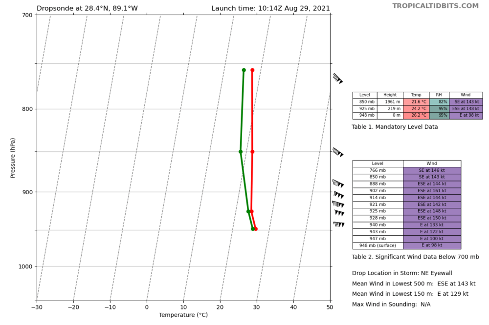
150 knots about 200 meters high...
-
The radar loop looks like the eye is moving north of northwest and is on track to make a beeline for downtown New Orleans.
-
Is it me or in the last hour did a new tiny eye just come in from the east and replace the old tiny eye?
-
Gonna be last year's Eta hilarious fantasy chaos as the next plane approaches the center.
-
Reminds me of last year when the plane was half way to Eta and then turned around during the most impressive satellite presentation of the storm and probably a cat 5.
-
Oh man that's a bummer at this point. Also looks like the NOAA plane is finished after only two center fixes. That's strange as the storm isn't far at all from Lakeland so they should have plenty of fuel.